
The Hydrography of the San Francisco Bay Area is a complex network of watersheds, marshes, rivers, creeks, reservoirs, and bays predominantly draining into the San Francisco Bay and Pacific Ocean.
The Hydrography of the San Francisco Bay Area is a complex network of watersheds, marshes, rivers, creeks, reservoirs, and bays predominantly draining into the San Francisco Bay and Pacific Ocean.
Superscript text
Map: Islands of the San Francisco Bay Area | |
|---|---|
 |
Map: Islands of Suisun Bay and the Sacramento–San Joaquin River Delta | |
|---|---|
 |
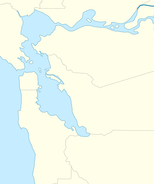
The largest bodies of water in the Bay Area are the San Francisco Bay, San Pablo Bay, and Suisun Bay. The San Francisco Bay is one of the largest bays in the world. Many inlets on the edges of the three major bays are designated as bays in their own right, such as Richardson Bay, San Rafael Bay, Grizzly Bay, and San Leandro Bay.
Nearby bays along the Pacific Coast include Bodega Bay, Tomales Bay, Drakes Bay, Bolinas Bay, and Half Moon Bay.
The largest rivers are the Sacramento and San Joaquin Rivers, which drain into the Sacramento-San Joaquin River Delta and thence to Suisun Bay. Other major rivers of the North Bay are the Napa River, the Petaluma River, the Gualala River, and the Russian River; the former two drain into San Pablo Bay, the latter two into the Pacific Ocean.
In the South Bay, the Guadalupe River drains into San Francisco Bay near Alviso.
The Bay Area has a network of streams that are generally called creeks, but sometimes called arroyos, due to the Spanish language heritage evident in names such as Santa Rosa Creek and San Pablo Creek. Due to low rainfall in the summer months (May–October), many Bay Area creeks are intermittent, flowing above ground only during part of the year.
Political groups have been formed to preserve creeks or restore creeks which have been culverted for development. Baxter Creek in Contra Costa County has been daylighted in various points along its piped route by Friends of Baxter Creek. Other organizations include Friends of Five Creeks, which monitors, restores, cleans and educates in relation to creeks flowing from the Berkeley Hills to the Eastshore Estuary in the East Bay. [1]
The Bay Area has springs which are the source of most of the minor creeks in the East Bay hills such as Garrity Creek. In the North Bay there are hot springs which serve as further tourist attractions to Wine Country tourists and spa goers.
The Bay Area has many lakes, particularly if one includes artificial ones such as Lake Berryessa. Some are very small (such as Jewel Lake in Berkeley) and others are covered (Summit Reservoir, for example). Lake Merced and Lake Merritt are salt lakes; the former is drying up while the latter is a closed off estuarine cove.
Due to pollution of surface water, much of the area's potable water is located underground, for instance in the Mocho Subbasin of the Livermore Valley. As these aquifers get drawn down by pumping, there is increasing interest in ways to speed up the recharging of these resources.
Prior to the introduction of European agricultural methods, the shores of San Francisco Bay consisted mostly of tidal marshes. Approximately 85% of those marshes have been lost or destroyed, but about 50 marshes and marsh fragments remain. [2] In the Delta area, marshes were drained for farmland. In San Francisco, marshes were filled in for urban development. In the East Bay, portions were used as landfill. In the South Bay, huge tracts have served as commercial salt evaporation ponds. In the North Bay, the Napa Sonoma Marsh and Point Molate Marsh remain productive ecosystems. Some wetlands have been restored or protected from further development. Success stories include Eastshore State Park and Crissy Field. Many native and recovered wetlands are preserved in the Don Edwards San Francisco Bay National Wildlife Refuge and the San Pablo Bay National Wildlife Refuge.
Wetlands also exist on the Pacific Coast (the Estero Americano, for instance) and in certain inland valleys: for example, the Laguna de Santa Rosa near Santa Rosa.
The Bay Area is a large natural harbor. Around it have grown seaports and naval facilities. Active ports include the ports of Richmond, Redwood City, San Francisco, and Oakland. Ships also traverse the bay heading to and from ports in Stockton and Sacramento. During World War I and World War II the region was the United States's major shipbuilding center for the Pacific. Former naval facilities include Point Molate Naval Fuel Depot, Alameda Point Naval Facility and Mare Island Naval Shipyard.
Many Bay Area cities have marinas, including Berkeley, Petaluma, and Redwood City.
There is also an extensive commuter ferry system, which is being expanded by the San Francisco Bay Water Transit Authority.
Oceanic harbors have been built at Bodega Bay and Half Moon Bay.

San Francisco Bay is a shallow estuary in the US state of California. It is surrounded by a contiguous region known as the San Francisco Bay Area, and is dominated by the large cities of San Jose, San Francisco and Oakland.

Sonoma County is a county in the U.S. state of California. As of the 2010 United States Census, its population was 483,878. Its county seat and largest city is Santa Rosa. It is to the north of Marin County and the south of Mendocino County. It is west of Napa County and Lake County.

Northern California is a geographic and cultural region that generally comprises the northern portion of the U.S. state of California. Spanning the state's northernmost 48 counties, its main population centers include the San Francisco Bay Area, the Greater Sacramento area, and the Metropolitan Fresno area. Northern California also contains redwood forests, along with the Sierra Nevada, including Yosemite Valley and part of Lake Tahoe, Mount Shasta, and most of the Central Valley, one of the world's most productive agricultural regions.

Wine Country is the region of California, in the northern Bay Area, known worldwide as a premier wine-growing region. The region is famed for its wineries, its cuisine, Michelin star restaurants, boutique hotels, luxury resorts, historic architecture, and culture. Viticulture and wine-making have been practiced in the region since the Spanish missionaries from Mission San Francisco Solano established the first vineyards in 1812.

San Pablo Bay is a tidal estuary that forms the northern extension of San Francisco Bay in the East Bay and North Bay regions of the San Francisco Bay Area in northern California.

Suisun Bay is a shallow tidal estuary in northern California. It lies at the confluence of the Sacramento River and San Joaquin River, forming the entrance to the Sacramento–San Joaquin River Delta, an inverted river delta. Suisun Marsh, the tidal marsh land to the north, is the largest marsh in California. Grizzly Bay forms a northern extension of Suisun Bay. Suisun Bay is directly north of Contra Costa County.

Sonoma Valley is a valley located in southeastern Sonoma County, California, in the North Bay region of the San Francisco Bay Area. Known as the birthplace of the California wine industry, the valley is home to some of the earliest vineyards and wineries in the state, some of which survived the phylloxera epidemic of the 1870s and the impact of prohibition in the early 20th century. Today, the valley's wines are protected by the U.S. Federal Government's Sonoma Valley and Carneros AVAs.

The Northwestern Pacific Railroad is a railroad covering the 62 mi (100 km) stretch between Schellville and Windsor with freight and Sonoma–Marin Area Rail Transit (SMART) commuter trains. Formerly, it was a regional railroad that served the entire North Coast of California, with a main line running 271 miles (436 km) from Schellville to Eureka, along with an additional portion of the line running from the Ignacio Wye to the edge of San Rafael. The portion of the NWP main line between the Ignacio Wye in Marin County and the depot in Healdsburg is owned by SMART. The Schellville–Ignacio and Healdsburg–Eureka portions are owned by the North Coast Railroad Authority (NCRA). Private contractor NWPco operates freight service under NCRA lease. California's 2018 Great Redwood Trail Act repurposes the abandoned railroad right-of-way from Eureka to the San Francisco Bay in Marin County for future use as the "Great Redwood Trail" rail-trail.

The Petaluma River is a river in the California counties of Sonoma and Marin that becomes a tidal slough for the majority of its length. The headwaters are in the area southwest of Cotati. The flow is generally southward through Petaluma's old town, where the waterway becomes navigable, and then flows another 10 mi (16 km) through tidal marshes before emptying into the northwest corner of San Pablo Bay.

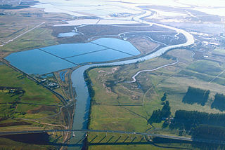
Located in northern California the Suisun Marsh has been referred to as the largest brackish water marsh on west coast of the United States of America. The marsh land is part of the San Francisco Bay tidal estuary, and subject to tidal ebb and flood. The marsh is home to many species of birds and other wildlife, and is formed by the confluence of the Sacramento and San Joaquin rivers between Martinez and Suisun City, California and several other smaller, local watersheds. Adjacent to Suisun Bay, the marsh is immediately west of the legally defined Sacramento-San Joaquin Delta as well as part of the San Francisco Bay estuary.

Area code 707 is a telephone area code in the North American Numbering Plan (NANP) for the northwestern part of the U.S. state of California. It was created by a split of area code 415 on March 1, 1959. It serves part of the northern San Francisco Bay Area, as well as the North Coast. Major cities in the area code include Napa, Sebastopol, Vallejo, Benicia, Fairfield, Santa Rosa, Windsor, Healdsburg, Rohnert Park, Petaluma, Fort Bragg, Crescent City, Eureka, Clearlake, Vacaville, and Ukiah.

Sonoma Creek is a 33.4-mile-long (53.8 km) stream in northern California. It is one of two principal drainages of southern Sonoma County, California, with headwaters rising in the rugged hills of Sugarloaf Ridge State Park and discharging to San Pablo Bay, the northern arm of San Francisco Bay. The watershed drained by Sonoma Creek is roughly equivalent to the wine region of Sonoma Valley, an area of about 170 square miles (440 km2). The State of California has designated the Sonoma Creek watershed as a “Critical Coastal Water Resource”. To the east of this generally rectangular watershed is the Napa River watershed, and to the west are the Petaluma River and Tolay Creek watersheds.

San Francisco Bay in California has been served by ferries of all types for over 150 years. John Reed established a sailboat ferry service in 1826. Although the construction of the Golden Gate Bridge and the San Francisco–Oakland Bay Bridge led to the decline in the importance of most ferries, some are still in use today for both commuters and tourists.
The Napa Sonoma Marsh is a wetland at the northern edge of San Pablo Bay, which is a northern arm of the San Francisco Bay in California, United States. This marsh has an area of 48,000 acres (194 km2), of which 13,000 acres (53 km2) are abandoned salt evaporation ponds. The United States Government has designated 13,000 acres (53 km2) in the Napa Sonoma Marsh as the San Pablo Bay National Wildlife Refuge.
Tolay Creek is a 12.5-mile-long (20.1 km) southward-flowing stream in southern Sonoma County, California, United States, which flows through Tolay Lake and ends in north San Pablo Bay.
Stege Marsh, also known as the South Richmond Marshes, is a tidal marshland wetlands area in Richmond, California in western Contra Costa County.

Novato Creek is a stream in eastern Marin County, California, United States. It originates in highlands between Red Hill and Mount Burdell above the city of Novato, California, and flows 17 miles (27 km) before emptying into San Pablo Bay south of Petaluma Point.
San Pablo Bay National Wildlife Refuge is a 13,190-acre (53.4 km2) National Wildlife Refuge in California established in 1970. It extends along the northern shore of San Pablo Bay, from the mouth of the Petaluma River, to Tolay Creek, Sonoma Creek, and ending at Mare Island.
The 1898 Mare Island earthquake occurred in Northern California on March 30 at 23:43 local time with a moment magnitude of 5.8–6.4 and a maximum Mercalli intensity of VIII–IX (Severe–Violent). Its area of perceptibility included much of northern and central California and western Nevada. Damage amounted to $350,000 and was most pronounced on Mare Island, a peninsula in northern San Francisco Bay. While relatively strong effects there were attributed to vulnerable buildings, moderate effects elsewhere in the San Francisco Bay Area consisted of damaged or partially collapsed structures, and there were media reports of a small tsunami and mostly mild aftershocks that followed.
