Port of Oakland

Last updated
Port of Oakland
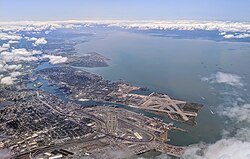
Oakland California aerial view.jpg
Aerial view of the port of Oakland
Port of Oakland logo.png
Port of Oakland
Click on the map for a fullscreen view
Location
Country United States
Location Oakland, California
Coordinates 37°47′43.92″N122°17′4.57″W / 37.7955333°N 122.2846028°W / 37.7955333; -122.2846028
Details
Opened1927
No. of berths 20
Draft depth 50 feet
Air draft 220 feet, restricted by Golden Gate Bridge
Statistics
Vessel arrivals1,775 (FY 2014) [1]
Annual container volume2,394,069  twenty-foot equivalent units  (TEU) (FY 2014) [1]
Website
https://www.portofoakland.com/

The Port of Oakland is a major container ship facility located in Oakland, California, in the San Francisco Bay. It was the first major port on the Pacific Coast of the United States to build terminals for container ships. As of 2022, it was the eighth busiest container port in the United States, behind the ports of Los Angeles, New York/New Jersey, Long Beach, Savannah, Houston, Virginia, and Seattle/Tacoma. [2] Development of an intermodal container handling system in 2002 after over a decade of planning and construction positions the Port of Oakland for further expansion of the West Coast freight market share. In 2019 it ranked 8th in the United States in the category of containers. [3]

Contents

Early history

In 1852, the year of Oakland's incorporation as a town by the California State Legislature, large shipping wharves were constructed along the Oakland Estuary, which was dredge d to create a viable shipping channel. 22 years later, in 1874, the previously dredged shipping channel was deepened to make Oakland a deep-water port.

In the late 19th century, Southern Pacific was granted exclusive rights to the port. In January 1906, a small work party employed by the Western Pacific Railroad built a crossing over the Southern Pacific line to connect the Western Pacific mainline with trackage built on an area of the landfill. This act was protested by Southern Pacific and later upheld in court. The court ruled that all landfills since the date of the agreement did not belong to Southern Pacific, ending their monopoly.

In 1921, a channel was dug thirty feet deep at mean low water from the bay to Brooklyn Basin, a distance of four and three quarters miles, and then a channel twenty-five feet deep around the basin and eighteen feet to San Leandro Bay, an added distance of four miles (6 km). The port was not officially named the Port of Oakland until 1927, under the leadership of the newly organized Board of Port Commissioners.

Under the Rivers and Harbors Act of 1922, the project produced a channel thirty feet deep and 800 feet wide through the shoal south of Yerba Buena Island, narrowing to 600 feet at the end of the Oakland jetties, widening the estuary channel to 600 feet to Webster Street, dredging the south channel basin to thirty feet and a turning basin, then thirty feet to Park Street, at a cost to the federal government of $6 million.

In 1962, the Port of Oakland began to admit container ships. Container traffic greatly increased the amount of cargo loaded and unloaded at the port. By the late 1960s, the Port of Oakland was the second-largest port in the world in terms of container tonnage. However, depth and navigation restrictions in San Francisco Bay limited its capacity, and by the late 1970s, it had been supplanted by the Ports of Los Angeles and Long Beach as the major container port on the West Coast.

During an expansion of the port in the late 1960s, fill material was added to what remained of the old Southern Pacific mole. The fill came largely from the concurrent excavation of the Berkeley Hills Tunnel during the construction of the BART system. [4] The BART trunk line also crosses over part of the port, and the east portal of the Transbay Tube that carries BART trains from Oakland to San Francisco lies within the port.

Recent history

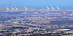
Cranes in the Port of Oakland Port of Oakland A.jpg
Cranes in the Port of Oakland
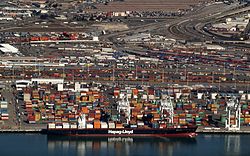
California's Green Trade Corridor Marine Highway project California Green Trade Corridor.jpg
California’s Green Trade Corridor Marine Highway project

One of the main limitations to growth was the inability to transfer containers to rail lines; all cranes historically operated between ocean vessels and trucks. In the 1980s, the Port of Oakland began the evaluation of the development of an intermodal container transfer capability, i.e., facilities that would allow trans-loading of containers from vessels to either trucks or rail modes. The port retained VZM, Korve Engineering, and Earth Metrics to perform engineering and environmental studies to allow detailed engineering to proceed. [5] In 1987, on behalf of the Oakland Port Commission, Allen Broussard led a group of 72 lawyers, port officials, including then-port commissioner Carole Ward Allen, and city officials on a 3-week trip to China, meeting the Mayor of Shanghai, Jiang Zemin (Shanghai is twinned with San Francisco). [6]

The completion of the resulting rail intermodal facility occurred in 2002. That brought the cumulative investment in port expansion to over $1.4 billion since 1962, half of which comprised the intermodal facility. In the early first decade of the 21st century, the new intermodal rail facility, along with severe congestion at the Ports of Los Angeles and Long Beach, caused some trans-Pacific shippers to move some of their traffic to the Port of Oakland (especially if the final destination is not in Southern California but lies farther east). Also, the port is now reaping the benefits of investment in post-panamax cranes, dredging, and the transfer of military property, which has now been used for expansion. [7]

The deepening of the port from 42 feet (13 m) to 50 feet (15 m) to accommodate larger ships has been completed. The ports of Los Angeles, Long Beach, Seattle, and Tacoma were already 50 feet (15 m) deep. The $432 million project was finished in September 2009. [8] Some 6 million cubic yards (4,600,000 m3) of mud from the dredging was deposited at the western edge of Middle Harbor Shoreline Park to become a 188-acre (76 ha) shallow-water wetlands habitat for marine and shore life. [9] Further dredging followed in 2011, to maintain the navigation channel. [10] [11] Prior to the March 2012 arrival of the MSC Fabiola , the largest container ship ever to enter the San Francisco Bay, the Port of Oakland prepared by checking channel depth and dredging as needed. The ship arrived with less than its full draft of 50 feet 10 inches (15.5 m) because it held only three-quarters of a load. [12]

Occupy Oakland, part of the Occupy movement, marched to the port on November 2, 2011, and blocked traffic from entering and leaving. [13] In August 2014, the port was the scene of a protest against an Israeli-owned ship by Palestinian supporters opposed to Israeli military actions in the Gaza Strip. [14] The ship's cargo was eventually unloaded after a 4-day standoff. The Jewish Press commented that unless the port found a solution to their "protester problem," there was a good chance the ship's owner and other cargo firms would find safer ports to do business with. [15]

The Port is part of the California’s Green Trade Corridor Marine Highway project, as ships move cargo much greener than trucks and trains. Green Trade Corridor Marine Highway (ports of Oakland-Stockton-West Sacramento) can improve goods movement through Northern California. [1]

Logo used until 2024 Port of Oakland logo.svg
Logo used until 2024

In June 2016, The Oakland City Council voted unanimously to ban the handling and storage of both coal and coke at the port. The Oakland City Council voted to ban the handling and storage of coal and coke at the city’s terminals and bulk material facilities. This decision came in opposition to developer Phil Tagami, CEO of the California Capital and Investment Group, financiers of the forthcoming Oakland Bulk and Oversized Terminal. [16]

Proposed Oakland Ballpark

The Oakland Athletics of Major League Baseball planned on constructing a new ballpark for the team at Howard Terminal. On April 26, 2018, the Port of Oakland commissioners voted 6-0 unanimously to enter in to a one-year agreement to negotiate exclusively with the Oakland A’s. [17] This agreement allowed the A’s to pay the Port $100,000 to study economic feasibility and environmental, transportation and accessibility issues.

On November 28, 2018, The Athletics announced that the team had chosen to build its 34,000-seat new ballpark at the Howard Terminal site at the Port of Oakland. [18] However, after delays in stadium planning, in 2023, the Oakland Athletics instead chose to move to Las Vegas, effectively ending the plans for the Howard Terminal Ballpark. [19]

San Francisco Bay Oakland International Airport

In addition to its maritime activities, the Port also operates San Francisco Bay Oakland International Airport. Developed land adjacent to the airport is also overseen by the Port, including the Airport Business Park. [20]

See also

Related Research Articles

<span class="mw-page-title-main">San Francisco Bay</span> Shallow estuary on the coast of California, United States

San Francisco Bay is a large tidal estuary in the U.S. state of California, and gives its name to the San Francisco Bay Area. It is dominated by the cities of San Francisco, San Jose, and Oakland.
<span class="mw-page-title-main">Containerization</span> Intermodal freight transport system

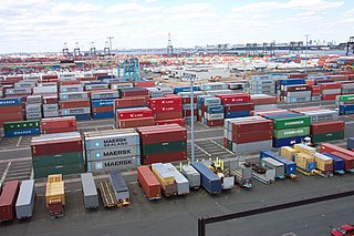
Containerization is a system of intermodal freight transport using intermodal containers. Containerization, also referred as container stuffing or container loading, is the process of unitization of cargoes in exports. Containerization is the predominant form of unitization of export cargoes, as opposed to other systems such as the barge system or palletization. The containers have standardized dimensions. They can be loaded and unloaded, stacked, transported efficiently over long distances, and transferred from one mode of transport to another—container ships, rail transport flatcars, and semi-trailer trucks—without being opened. The handling system is mechanized so that all handling is done with cranes and special forklift trucks. All containers are numbered and tracked using computerized systems.

<span class="mw-page-title-main">Intermodal freight transport</span> Cargo transport using multiple containers

Intermodal freight transport involves the transportation of freight in an intermodal container or vehicle, using multiple modes of transportation, without any handling of the freight itself when changing modes. The method reduces cargo handling, and so improves security, reduces damage and loss, and allows freight to be transported faster. Reduced costs over road trucking is the key benefit for inter-continental use. This may be offset by reduced timings for road transport over shorter distances.

<span class="mw-page-title-main">Port of Los Angeles</span> Harbor in Los Angeles, California

The Port of Los Angeles is a seaport managed by the Los Angeles Harbor Department, a unit of the City of Los Angeles. It occupies 7,500 acres (3,000 ha) of land and water with 43 miles (69 km) of waterfront and adjoins the separate Port of Long Beach. Promoted as "America's Port", the port is located in San Pedro Bay in the San Pedro and Wilmington neighborhoods of Los Angeles, approximately 20 miles (32 km) south of downtown.

<span class="mw-page-title-main">Ferry slip</span> Docking facility for a ferry

A ferry slip is a specialized docking facility that receives a ferryboat or train ferry. A similar structure called a barge slip receives a barge or car float that is used to carry wheeled vehicles across a body of water.

<span class="mw-page-title-main">PortMiami</span> Port in United States

The Port of Miami, styled as PortMiami and formally known as the Dante B. Fascell Port of Miami, is a major seaport located in Biscayne Bay at the mouth of the Miami River in Miami, Florida. It is the largest passenger port in the world and one of the largest cargo ports in the United States.

<span class="mw-page-title-main">Oakland Ballpark</span> Proposed baseball stadium in Oakland, California

Howard Terminal Ballpark was a proposed baseball stadium to be built in the Jack London Square neighborhood of Oakland, California. If approved and constructed, it would have served as the new home stadium of the Oakland Athletics of Major League Baseball, replacing the Oakland Coliseum. The 34,000-seat stadium was the last of several proposals to keep the Athletics in Oakland. The site is currently a parcel of land owned by the Port of Oakland. After securing the site, the Athletics planned to have the stadium built and operational after the team's lease expired at the Oakland Coliseum in 2024.

<span class="mw-page-title-main">Houston Ship Channel</span> Canal in Texas

The Houston Ship Channel, in Houston, Texas, is part of the Port of Houston, one of the busiest seaports in the world. The channel is the conduit for ocean-going vessels between Houston-area terminals and the Gulf of Mexico, and it serves an increasing volume of inland barge traffic.

<span class="mw-page-title-main">Port of San Francisco</span> Organization that oversees port facilities in San Francisco, California, United States

The Port of San Francisco is a semi-independent organization that oversees the port facilities at San Francisco, California, United States. It is run by a five-member commission, appointed by the Mayor and approved by the Board of Supervisors. The Port is responsible for managing the larger waterfront area that extends from the anchorage of the Golden Gate Bridge, along the Marina district, all the way around the north and east shores of the city of San Francisco including Fisherman's Wharf and the Embarcadero, and southward to the city line just beyond Candlestick Point. In 1968, the State of California, via the California State Lands Commission for the State-operated San Francisco Port Authority, transferred its responsibilities for the Harbor of San Francisco waterfront to the City and County of San Francisco / San Francisco Harbor Commission through the Burton Act AB2649. All eligible State port authority employees had the option to become employees of the City and County of San Francisco to maintain consistent operation of the Port of San Francisco.

<span class="mw-page-title-main">Port of Stockton</span> Deepwater port in the United States

The Port of Stockton is a major deepwater port on the Stockton Ship Channel of the Pacific Ocean and an inland port located more than seventy nautical miles from the ocean, in Stockton, California on the Stockton Channel and San Joaquin River-Stockton Deepwater Shipping Channel. By land acreage, the Port of Stockton is the 2nd largest port in the State of California and sits on about 4,200 acres (17 km2), and occupies an island in the Sacramento–San Joaquin River Delta, and a portion of a neighborhood known as Boggs Tract. It is governed by a commission appointed by the City of Stockton and San Joaquin County. The Port of Stockton is a self-sustaining economic powerhouse in the Central Valley and in 2023, employed over 10,000 people and contributed over $78 million in state and local tax funds.

<span class="mw-page-title-main">Port of New York and New Jersey</span> Port in New York and New Jersey, United States

The Port of New York and New Jersey is the port district of the New York-Newark metropolitan area, encompassing the region within approximately a 25-mile (40 km) radius of the Statue of Liberty National Monument.

<span class="mw-page-title-main">Sacramento Deep Water Ship Channel</span> Canal in Sacramento County, California, United States

The Sacramento Deep Water Ship Channel is a canal from the Port of Sacramento in West Sacramento, California, to the Sacramento River, which flows into San Francisco Bay. It was completed by the United States Army Corps of Engineers in 1963. The channel is about 30 feet (9.1 m) deep, 200 feet (61 m) wide, and 43 miles (69 km) long.

<span class="mw-page-title-main">Port of Sacramento</span> Port in United States

The Port of Sacramento, now known as the Port of West Sacramento, is an inland port in West Sacramento, California, in the Sacramento metropolitan area. It is 79 nautical miles (146 km) northeast of San Francisco, and is centered in the California Central Valley, one of the richest agricultural regions in the world.

<span class="mw-page-title-main">Port of Redwood City</span> Port in the San Francisco Bay

The Port of Redwood City is a marine freight terminal on the western side of the southern San Francisco Bay, on the West Coast of the United States. This marine terminal is situated within the city of Redwood City, California. The port was developed from a natural deepwater channel discovered in the year 1850, at the mouth of Redwood Creek. From the early use as a log float port, commercial use expanded to a variety of industrial commodities; moreover, it is considered the birthplace of shipbuilding on the North American west coast. As of 2004 the annual freight shipments have reached about two million metric tons. The Port of Redwood City provides berths for dry bulk, liquid bulk, and project cargoes, along with certain recreational opportunities and public access to San Francisco Bay.

<span class="mw-page-title-main">Redwood Creek (San Mateo County)</span> River in California, United States

Redwood Creek is a 9.5-mile-long (15.3 km) perennial stream located in San Mateo County, California, United States which discharges into South San Francisco Bay. The Port of Redwood City, the largest deepwater port in South San Francisco Bay, is situated on the east bank of Redwood Creek near its mouth, where the creek becomes a natural deepwater channel.

<span class="mw-page-title-main">Punta Colonet</span> Town in Baja California, Mexico

Punta Colonet is a town located in Ensenada Municipality, Baja California, Mexico. Located 115 km (71 mi) south of the city of Ensenada, the community is located in an agriculturally productive region of Baja California spurred on by its location along Mexican Federal Highway 1 and proximity to agricultural markets in the United States.

The Virginia Port Authority (VPA) is an autonomous agency of the Commonwealth of Virginia that owns The Port of Virginia, a group of facilities with their activity centered on the harbor of Hampton Roads, Virginia.

<i>Madrid Express</i>

Madrid Express is a container ship built for the Hamburg based Peter Döhle Schiffahrtsgesellschaft by Samsung Heavy Industries in South Korea. The ship was initially chartered by the Mediterranean Shipping Company (MSC) as the MSC Fabiola. From 2019 onwards the ship was chartered to Hapag-Lloyd as the Madrid Express. In 2012 the MSC Fabiola became the largest container ship to ever dock in North America, and the largest ship to enter the San Francisco Bay.

<span class="mw-page-title-main">Haldia Port</span> Port in India

Haldia Port, officially Haldia Dock Complex (HDC), is a port on the river bank of the confluence of the Haldi River and the Hooghly River. The port is located on the west bank of the Hooghly River at Haldia in West Bengal, about 121 km from the deep sea (sandheads), 45 kilometres (28 mi) upstream from Pilotage Station and 104 km downstream of Kolkata. It developed in independent India in the 1960s, and officially began operations in 1977 as an associate port of the Port of Kolkata. The dock system of the port consists of a lock and riverside jetties. Haldia port mainly handles fully loaded Handy size –carriers of 28,000–40,000 DWT–vessels; but the port has a maximum draft depth of 9 metres (30 ft) and can accommodate Panamax vessels up to 230 metres (750 ft) long with 40-50-percent cargo parcels.

References

  1. 1 2 3 "Oakland Seaport". Oakland Seaport.
  2. "One Hundred Container Ports 2023". Lloyd's List. Retrieved 2023-08-27.
  3. "Workbook: PortProfiles2020".
  4. Berkeley Gazette, October 24, 1966, p.13
  5. Initial Study: Intermodal Interface Demonstration Project, Port of Oakland, Oakland, California, Earth Metrics and Korve Engineerning, December 20, 1989
  6. "In Memoriam: Honorable Allen E. Broussard (1929 – 1996)".
  7. "Port of Oakland Official Site: Facts and Figures (2006)". Archived from the original on August 8, 2013.
  8. Selna, Robert (September 25, 2009). "Port of Oakland digs deep for greater capacity". SFGATE.
  9. Port of Oakland (September 21, 2009). "Port of Oakland, California, completes 50-foot-deepening project, allowing it to accommodate larger container ships". Industry Intelligence. Archived from the original on February 1, 2014. Retrieved March 23, 2012.
  10. "USA: Port of Oakland Secures USD 18 Million in Federal Funding for Dredging Project". Dredging Today. June 1, 2011. Retrieved March 22, 2012.
  11. "USA: Congresswoman Helps Oakland Port Reach Major Funding Milestone for Deepening Project". Dredging Today. March 21, 2012. Retrieved March 22, 2012.
  12. Matthews, Mark (March 22, 2012). "Huge container ship cruises into Port of Oakland". ABC7. San Francisco: KGO-TV/DT. Archived from the original on September 15, 2012. Retrieved March 23, 2012.
  13. Bulwa, Demian, Matthai Kuruvila, and Kevin Fagan (November 2, 2011). "Occupy Oakland throng closes down port". The San Francisco Chronicle. Retrieved November 5, 2011.{{cite news}}: CS1 maint: multiple names: authors list (link)
  14. "Demonstration on U.S. dock prevents workers from unloading Israeli ship". San Francisco Star. 19 August 2014. Retrieved 19 August 2014.
  15. "ILWU distances union from Gaza protest at Oakland". CBS. 20 August 2014. Retrieved 20 August 2014.
  16. "1467106207".
  17. "Port of Oakland OKs A's wish to study Howard Terminal ballpark". The Mercury News. 2018-04-27. Retrieved 2018-10-20.
  18. "A's settle on a ballpark site and a futuristic stadium". The Mercury News. 2018-11-28. Retrieved 2018-11-28.
  19. "On the move? Oakland Athletics announce Las Vegas land deal". The Mercury News. 2023-04-28. Retrieved 2023-10-26.
  20. "Port of Oakland - Real Estate". Archived from the original on 2012-05-10. Retrieved 2012-04-06.

37°47′43.92″N122°17′4.57″W / 37.7955333°N 122.2846028°W / 37.7955333; -122.2846028