
San Francisco Bay is a shallow estuary in the US state of California. It is surrounded by a contiguous region known as the San Francisco Bay Area, and is dominated by the large cities of San Jose, San Francisco and Oakland.

Contra Costa County is a county in the state of California in the United States. As of the 2010 census, the population was 1,049,025. The county seat is Martinez. It occupies the northern portion of the East Bay region of the San Francisco Bay Area, and is primarily suburban. The county's name is Spanish for "opposite coast", referring to its position on the other side of the bay from San Francisco. Contra Costa County is included in the San Francisco–Oakland–Berkeley, CA Metropolitan Statistical Area.
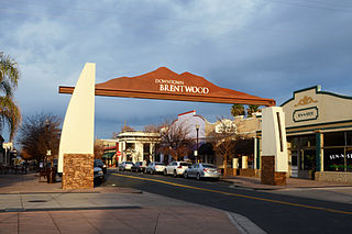
Brentwood is a city in Contra Costa County, California, United States. It is located in the East Bay region of the San Francisco Bay Area. The population is 51,481 as of 2010, an increase of 121 percent from 23,302 at the 2000 census.

The East Bay Regional Park District (EBRPD) is a special district operating in Alameda County and Contra Costa County, California, within the East Bay area of the San Francisco Bay Area. It maintains and operates a system of regional parks which is the largest urban regional park district in the United States. The administrative office is located in Oakland.

San Pablo Bay is a tidal estuary that forms the northern extension of San Francisco Bay in the East Bay and North Bay regions of the San Francisco Bay Area in northern California.

Suisun Bay is a shallow tidal estuary in northern California. It lies at the confluence of the Sacramento River and San Joaquin River, forming the entrance to the Sacramento–San Joaquin River Delta, an inverted river delta. Suisun Marsh, the tidal marsh land to the north, is the largest marsh in California. Grizzly Bay forms a northern extension of Suisun Bay. Suisun Bay is directly north of Contra Costa County.

Brannan Island State Recreation Area is a state park unit of California, United States, preserving a maze of waterways in the Sacramento–San Joaquin River Delta. The recreation area is located in Sacramento County between Rio Vista and Isleton. This park northeast of San Francisco Bay has countless islands and marshes with many wildlife habitats and many opportunities for recreation, including boating, windsurfing and swimming. The 329-acre (133 ha) park was established in 1952.

The Sacramento–San Joaquin River Delta, or California Delta, is an expansive inland river delta and estuary in Northern California. The Delta is formed at the western edge of the Central Valley by the confluence of the Sacramento and San Joaquin rivers and lies just east of where the rivers enter Suisun Bay. The Delta is recognized for protection by the California Bays and Estuaries Policy. Sacramento–San Joaquin Delta was designated a National Heritage Area on March 12, 2019. The city of Stockton is located on the San Joaquin River on the eastern edge of the delta. The total area of the Delta, including both land and water, is about 1,100 square miles (2,800 km2). Its population is around 500,000 residents.
Delta Meadows River Park (DMRP) is a state park property of California, USA, preserving an undeveloped piece of the Sacramento–San Joaquin River Delta. At present it is officially closed to the public and has no visitor services. The park encompasses sloughs, wet meadows, and an island between the Sacramento and Mokelumne Rivers. It is located near the historic Chinese American town of Locke, 28 miles (45 km) equidistant from Sacramento and Stockton. The 472-acre (191 ha) property was established in 1985.

John A. Nejedly was a district attorney and Republican state senator who represented Contra Costa County, California from 1958 to 1980.

The Contra Costa Canal is a 47 mi (76 km) aqueduct in the U.S. state of California. Its construction began in 1937, with delayed completion until 1948 due to World War II shortages in labor and materials. A portion of the canal's right of way has been developed as the Contra Costa Canal Regional Trail, a biking and walking trail, and is managed by the East Bay Regional Park District.
Antioch/Oakley Regional Shoreline is a regional park that is part of the East Bay Regional Parks system. It is located on the south shore of the San Joaquin River in Contra Costa County, California, between the cities of Antioch and Oakley. It is owned by the State of California and operated on a no-cost lease by the East Bay Regional Parks District. The park was begun in 1979, when the adjacent John Nejedly Bridge was constructed across the river. The park was originally named Antioch Regional Shoreline, and was given its present name when Oakley incorporated as a city in 1999.
Waterbird Regional Preserve is a 192 acres (0.78 km2) regional park located in Contra Costa County, California, adjacent to the city of Martinez, CA. It is part of the East Bay Regional Park District (EBRPD). It primarily consists of an area known as McNabney Marsh, which lies alongside Interstate 680 near the Sacramento-San Joaquin Delta and between two large and active oil refineries. The marsh drains into Suisun Bay via Peyton Slough. The area provides habitat for a wide variety of waterfowl and shorebirds for resting and feeding.
Browns Island is a regional preserve of the East Bay Regional Park District (EBRPD) in Pittsburg, Contra Costa County, California, United States. It is an island in Suisun Bay, part of the Sacramento-San Joaquin River Delta, separated from Pittsburg by New York Slough. The 595-acre (241 ha) island is separated from Winter Island to the east by Middle Slough, and bounded by New York Slough on the south and Suisun Bay on the west and northwest. The East Bay Regional Park District has published a guide to the wild plants that grow on this island.

The Los Vaqueros Reservoir is located in the northern Diablo Range, within northeastern Contra Costa County, northern California. It was completed by the Contra Costa Water District (CCWD) in 1998 to improve the quality of drinking water for its 550,000 customers in Central and Eastern Contra Costa County, and the reservoir is accessible via Vasco Road, a road which connects Brentwood and Livermore.

Alhambra Creek is a stream in Contra Costa County, in the East Bay region of the San Francisco Bay Area in northern California.
Crockett Hills Regional Park is a regional park in Contra Costa County, California, just south of Crockett. opened to the public in 2006. Part of the East Bay Regional Park District, it consists of 1,939 acres (7.85 km2) of rolling grasslands, wooded ravines and shoreline along the south bank of the Carquinez Strait. Its elevation ranges from 100 feet (30 m) to 800 feet (240 m) above sea level. The higher elevations offer good views of San Pablo Bay, the Sacramento - San Joaquin Delta, Mount Tamalpais, and Mount Diablo.

Sherman Island is an island in the Sacramento-San Joaquin River Delta at the confluence of the two rivers in Sacramento County, California, 1.2 miles (1.9 km) northeast of Antioch. The 5,500 ha island is the meeting point of Sacramento-, Solano-, and Contra Costa-Counties, and is bordered on the north and northwest by the Sacramento River, on the northeast by Three Mile Slough, and on the east, and south west by the San Joaquin River. Sherman Island is a widely known kite and windsurfing area.

Marsh Creek is a stream in east Contra Costa County, California in Northern California which rises on the eastern side of Mount Diablo and flows 30 miles (48 km) to the Sacramento–San Joaquin River Delta at Oakley, California, near Big Break Regional Shoreline. The creek flows through Marsh Creek State Park (California), where water is impounded to form Marsh Creek Reservoir, then through the city of Brentwood, California.

Stockton Deepwater Shipping Channel also called the Baldwin-Stockton Deepwater Shipping Channel or Stockton Deep Water Channel is a manmade deepwater water channel that runs from Suisun Bay and the Sacramento River - Sacramento Deep Water Ship Channel to the Port of Stockton and the Stockton Channel in California. The Stockton Ship Channel is 41 mi (66 km) long and about 37 ft (11 m) deep, allowing up to Panama Canal size ocean ships access to the Port of Stockton at the City of Stockton. The Stockton Deepwater Shipping Channel is part of the vast Sacramento–San Joaquin River Delta that has a connection to the Pacific Ocean. Stockton Deepwater Shipping Channel is also called the lower San Joaquin River.

