
The San Francisco–Oakland Bay Bridge, commonly referred to as the Bay Bridge, is a complex of bridges spanning San Francisco Bay in California. As part of Interstate 80 and the direct road between San Francisco and Oakland, it carries about 260,000 vehicles a day on its two decks. It includes one of the longest bridge spans in the United States.

A bascule bridge is a moveable bridge with a counterweight that continuously balances a span, or leaf, throughout its upward swing to provide clearance for boat traffic. It may be single- or double-leafed.

The Key System was a privately owned company that provided mass transit in the cities of Oakland, Berkeley, Alameda, Emeryville, Piedmont, San Leandro, Richmond, Albany, and El Cerrito in the eastern San Francisco Bay Area from 1903 until 1960, when it was sold to a newly formed public agency, AC Transit. The Key System consisted of local streetcar and bus lines in the East Bay, and commuter rail and bus lines connecting the East Bay to San Francisco by a ferry pier on San Francisco Bay, later via the lower deck of the Bay Bridge. At its height during the 1940s, the Key System had over 66 miles (106 km) of track. The local streetcars were discontinued in 1948 and the commuter trains to San Francisco were discontinued in 1958. The Key System's territory is today served by BART and AC Transit bus service.

Coast Guard Base Alameda also referred to as Coast Guard Island is an artificial island in the Oakland Estuary between Oakland and Alameda, California. It is home to several major United States Coast Guard commands and cutters, including the Coast Guard Pacific Area. It is one of the largest Coast Guard bases on the West Coast. From 1942 until 1982, the island was the site of the Coast Guard's recruiting training center, enlisting and training hundreds of thousands of coast guardsmen including many of the 214,239 who served in the Pacific and European Theaters of World War II.

The East Bay Electric Lines were a unit of the Southern Pacific Railroad that operated electric interurban-type trains in the East Bay region of the San Francisco Bay Area. Beginning in 1862, the SP and its predecessors operated local steam-drawn ferry-train passenger service in the East Bay on an expanding system of lines, but in 1902 the Key System started a competing system of electric lines and ferries. The SP then drew up plans to expand and electrify its system of lines and this new service began in 1911. The trains served the cities of Berkeley, Albany, Emeryville, Oakland, Alameda, and San Leandro transporting commuters to and from the large Oakland Pier and SP Alameda Pier. A fleet of ferry boats ran between these piers and the docks of the Ferry Building on the San Francisco Embarcadero.
The Posey and Webster Street Tubes are two parallel underwater tunnels connecting the cities of Oakland and Alameda, California, running beneath the Oakland Estuary. Both are immersed tubes, constructed by sinking precast concrete segments to a trench in the Estuary floor, then sealing them together to create a tunnel. The Posey Tube, completed in 1928, currently carries one-way (Oakland-bound) traffic under the Estuary, while the Webster Street Tube, completed in 1963, carries traffic from Oakland to Alameda.

The Oakland Estuary is the strait in the San Francisco Bay Area, California, separating the cities of Oakland and Alameda and the Alameda Island from the East Bay mainland. On its western end, it connects to San Francisco Bay proper, while its eastern end connects to San Leandro Bay.

San Francisco Bay in California has been served by ferries of all types for over 150 years. John Reed established a sailboat ferry service in 1826. Although the construction of the Golden Gate Bridge and the San Francisco–Oakland Bay Bridge led to the decline in the importance of most ferries, some are still in use today for both commuters and tourists.

Moore Dry Dock Company was a ship repair and shipbuilding company in Oakland, California. In 1905, Robert S. Moore, his brother Joseph A. Moore, and John Thomas Scott purchased the National Iron Works located in the Hunter's Point section of San Francisco, and founded a new company, the Moore & Scott Iron Works Moore had previously been vice president of the Risdon Iron Works of San Francisco. Scott was nephew to Henry T. and Irving M. Scott, owners of the nearby Union Iron Works, where John had risen from apprentice to superintendent. Their new business was soon destroyed by fire resulting from the San Francisco earthquake.

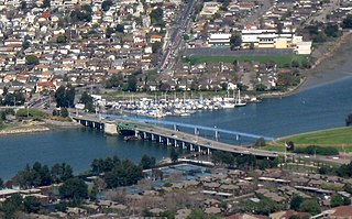
The Park Street Bridge is a double-leaf bascule drawbridge spanning 372 feet of the Oakland Estuary in the San Francisco Bay Area. It links the cities of Oakland and Alameda. In a year, the bridge is opened approximately 1700 times and carries approximately 40,000 vehicles per work day. It was built when the Oakland Estuary was trenched, converting Alameda from a peninsula to an island.

The Fruitvale Bridge and the Fruitvale Avenue Bridge are parallel bridges that cross the Oakland Estuary, linking the cities of Oakland and Alameda in California. The Fruitvale Bridge is a vertical-lift Warren through truss railroad moveable bridge, while the Fruitvale Avenue Bridge is a steel stringer road bascule bridge that connects Fruitvale Avenue in Oakland with Tilden Way in Alameda.
The San Francisco and Alameda Railroad (SF&A) was a short-lived railroad company in the East Bay area of the San Francisco Bay Area. The railroad line opened 1864–1865 from Alameda Terminal on Alameda Island to Hayward, California, with ferry service between Alameda Terminal and San Francisco started in 1864. After being bankrupted by the 1868 Hayward earthquake, it was acquired by a subsidiary of the Central Pacific Railroad in August 1869. Part of the SF&A line between Alameda Terminal and San Leandro served as a portion of the First transcontinental railroad starting in September 1869, while the southern section was abandoned in 1873.

The Oakland Ferry Terminal is a ferry terminal on the San Francisco Bay, located in Jack London Square in Oakland, California.

The Southern Crossing is a proposed highway structure that would span San Francisco Bay in California, somewhere south of the San Francisco–Oakland Bay Bridge and north of the San Mateo–Hayward Bridge. Several proposals have been made since 1947, varying in design and specific location, but none of them have ever been implemented because of cost, environmental and other concerns.

The Portola Road Race was an automobile race spanning several cities of Alameda County, California, in 1909 and 1911, the start/finish line positioned in Oakland. The races were held in concert with the Portola Festival celebrating San Francisco's renewal following the devastation of the 1906 earthquake.
Alameda Island is an island located in the San Francisco Bay in California. It is south and west of, and adjacent to, Oakland, and across the bay eastward from San Francisco. Located on the island is most of the city of Alameda, a city in Alameda County. A very small western tip of the island's territory is technically part of San Francisco; however, this is uninhabited and is not separately managed. Alameda Island is the most populated island in the continental United States that is not located in the New York City metropolitan area.

The Dumbarton Rail Bridge lies just to the south of the Dumbarton road bridge. Built in 1910, the rail bridge was the first structure to span San Francisco Bay, shortening the rail route between Oakland and San Francisco by 26 miles (42 km). The last freight train traveled over the bridge in 1982, and it has been proposed since 1991 to reactivate passenger train service to relieve traffic on the road bridges, though this would entail a complete replacement of the existing bridge. Part of the western timber trestle approach collapsed in a suspected arson fire in 1998.

The Rio Vista Bridge is a continuous truss span with a vertical-lift bridge in the middle which carries California State Route 12 across the Sacramento River at Rio Vista, California. The present bridge was completed in 1960 and is one of several moveable bridges spanning rivers in the Sacramento–San Joaquin River Delta. It is named after Helen Madere, who served as vice-mayor of Rio Vista. As of 2013 the bridge carries approximately 21,000 cars per day.
The San Leandro Bay Bridge, better known as the Bay Farm Island Bridge, is a single-leaf bascule drawbridge spanning the San Leandro Channel, the inlet of San Leandro Bay within the San Francisco Bay Area, California, United States. It carries California State Route 61 and links the main island of Alameda with Bay Farm Island within the city of Alameda. The present bridge was completed in 1953; it is paralleled by a second bridge devoted to pedestrian and bicycle traffic, the Bay Farm Island Bicycle Bridge.


