The Key System was a privately owned company that provided mass transit in the cities of Oakland, Berkeley, Alameda, Emeryville, Piedmont, San Leandro, Richmond, Albany, and El Cerrito in the eastern San Francisco Bay Area from 1903 until 1960, when it was sold to a newly formed public agency, AC Transit. The Key System consisted of local streetcar and bus lines in the East Bay, and commuter rail and bus lines connecting the East Bay to San Francisco by a ferry pier on San Francisco Bay, later via the lower deck of the Bay Bridge. At its height during the 1940s, the Key System had over 66 miles (106 km) of track. The local streetcars were discontinued in 1948 and the commuter trains to San Francisco were discontinued in 1958. The Key System's territory is today served by BART and AC Transit bus service.

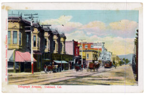
Telegraph Avenue is a street that begins, at its southernmost point, in the midst of the historic downtown district of Oakland, California, and ends, at its northernmost point, at the southern edge of the University of California, Berkeley campus in Berkeley, California. It is approximately 4.5 miles (7.2 km) in length.

Downtown Berkeley station is an underground Bay Area Rapid Transit (BART) station in the Downtown Berkeley section of Berkeley, California. It is served by the Orange and Red lines.

The Western Railway Museum, in Solano County, California is located on Highway 12 between Rio Vista and Suisun. The museum is built along the former mainline of the Sacramento Northern Railway. Their collection focuses on trolleys, as it is primarily a museum of interurban transit equipment.
The Los Angeles Railway was a system of streetcars that operated in Central Los Angeles and surrounding neighborhoods between 1895 and 1963. The system provided frequent local services which complemented the Pacific Electric "Red Car" system's largely commuter-based interurban routes. The company carried many more passengers than the Red Cars, which served a larger and sparser area of Los Angeles.

Idora Park was a 17.5-acre (71,000 m2) Victorian era trolley park in north Oakland, California constructed in 1904 on the site of an informal park setting called Ayala Park on the north banks of Temescal Creek. It was leased by the Ingersoll Pleasure and Amusement Park Company that ran several Eastern pleasure parks. What began as a pleasure ground in a rural setting for Sunday picnics evolved into a complete amusement park visited by many residents of the San Francisco Bay Area. Its popularity declined after the advent of the automobile, and it was closed and demolished in 1929.

Temescal is one of the oldest neighborhoods in Oakland, California, located in North Oakland, and centered on Telegraph Avenue. The neighborhood derives its name from Temescal Creek, a significant watercourse in the city.

The Shipyard Railway was an electric commuter rail/interurban line that served workers at the Richmond Shipyards in Richmond, California, United States, during World War II. It was funded by the United States Maritime Commission and was built and operated by the Key System, which already operated similar lines in the East Bay. The line ran from a pair of stations on the Emeryville/Oakland border – where transfer could be made to other Key System lines – northwest through Emeryville, Berkeley, Albany, and Richmond to the shipyards. It operated partially on city streets and partially on a dedicated right-of-way paralleling the Southern Pacific Railroad mainline.

The East Bay Electric Lines were a unit of the Southern Pacific Railroad that operated electric interurban-type trains in the East Bay region of the San Francisco Bay Area. Beginning in 1862, the SP and its predecessors operated local steam-drawn ferry-train passenger service in the East Bay on an expanding system of lines, but in 1902 the Key System started a competing system of electric lines and ferries. The SP then drew up plans to expand and electrify its system of lines and this new service began in 1911. The trains served the cities of Berkeley, Albany, Emeryville, Oakland, Alameda, and San Leandro transporting commuters to and from the large Oakland Pier and SP Alameda Pier. A fleet of ferry boats ran between these piers and the docks of the Ferry Building on the San Francisco Embarcadero.

Temescal Creek is one of the principal watercourses in the city of Oakland, California, United States.

The Sacramento Northern Railway was a 183-mile (295 km) electric interurban railway that connected Chico in northern California with Oakland via the California capital, Sacramento. In its operation it ran directly on the streets of Oakland, Sacramento, Yuba City, Chico, and Woodland and ran interurban passenger service until 1941 and freight service into the 1960s.

The Tidewater Southern Railway was a short line railroad in Central California in the United States. For most of its history, it was a subsidiary of the Western Pacific Railroad. It was originally built as an interurban system, connecting to the Central California Traction Company, Western Pacific Railroad, Southern Pacific Railroad and Atchison, Topeka and Santa Fe Railway in Stockton, California. Its mainline went southeast from Stockton to Escalon, California and thence to Modesto, California before splitting into two branches ending at the towns of Turlock and Hilmar. Until the mid-1930s, there were plans to extend the line to Fresno and even toward the Los Angeles area. Today, much of the line is still operated by the Union Pacific Railroad. Of all the former interurban railroads in California, the former Tidewater Southern retains the highest percentage of still operating trackage.
The North Pacific Coast Railroad (NPC) was a common carrier 3 ft (914 mm) narrow-gauge steam railroad begun in 1874 and sold in 1902 to new owners who renamed it the North Shore Railroad (California) (NSR) and which rebuilt the southern section into a standard-gauge electric railway.

The Peninsular Railway was an interurban electrified railway in the U.S. State of California in the United States of America. It served the area between San Jose, Los Gatos, and Palo Alto, comprising much of what is today known as "Silicon Valley". For much of its existence it was a subsidiary of the Southern Pacific Railroad.

Berkeley Station was the name of the principal railroad station in Berkeley, California from 1878 to 1911. It was located in what is now downtown Berkeley, on Shattuck Avenue between University Avenue and Center Street. The tract is today occupied by Shattuck Square and Berkeley Square. The name continued in use after 1911 although the station was no longer the main rail depot for Berkeley.

The Alameda Mole was a transit and transportation facility in Alameda, California for ferries landing in the East Bay of San Francisco from 1878 to the 1930s. It was located on the west end of Alameda, and later became part of the Alameda Naval Air Station. It was one of four neighboring moles. The others were the Oakland Mole, the WP Mole, and the Key System Mole. The purpose of the mole was to extend tracks of rail-based transportation lines beyond the shallow mud flats along the shore of the East Bay into water deep enough to accommodate the passenger and rail ferries to San Francisco.
The San Francisco and Oakland Railroad (SF&O) was built in 1862 to provide ferry-train service from a San Francisco ferry terminal connecting with railroad service through Oakland to San Antonio. In 1868 Central Pacific Railroad decided that Oakland would be the west coast terminus of the First transcontinental railroad and bought SF&O. Beginning November 8, 1869, part of the SF&O line served as the westernmost portion of the transcontinental railroad. It subsequently was absorbed into the Southern Pacific Railroad (SP). The track in Oakland was electrified in 1911 and extended across the San Francisco-Oakland Bay Bridge in 1939. Service was abandoned in 1941.

The Northbrae Tunnel, also referred to as the Solano Avenue Tunnel, was built as a commuter electric railroad tunnel in the northern part of Berkeley, California, and was later converted to street use.

Shattuck Avenue is a major city street running north–south through Berkeley and Oakland, California. At its southern end, the street branches from Telegraph Avenue in Oakland's Temescal district, then ends at Indian Rock Park in the Berkeley Hills to the north. Shattuck Avenue is the main street of Berkeley, forming the spine of that city's downtown, and the site of the Gourmet Ghetto in North Berkeley. The street was named for Francis Kittredge Shattuck, an early landowner and booster who later served as Mayor of Oakland. Shattuck was largely responsible for the original construction of the road as well as for a railroad built along its route.