Walnut Creek station

Last updated
Walnut Creek
Walnut Creek station from south garage, November 2019.JPG
Walnut Creek station in November 2019
General information
Location200 Ygnacio Valley Road
Walnut Creek, California
Coordinates 37°54′21″N122°04′02″W / 37.905724°N 122.067332°W / 37.905724; -122.067332
Owned by San Francisco Bay Area Rapid Transit District
Line(s) BART C-Line
Platforms2 side platforms
Tracks2
Connections
Construction
Structure typeElevated
Parking2,089 spaces
Bicycle facilities64 lockers
AccessibleYes
ArchitectGwathmey, Sellier & Crosby
Joseph Esherick & Associates [1]
History
OpenedMay 21, 1973 (1973-05-21)
Passengers
20242,637 (weekday average) [2]
Services
Preceding station Bart compact logo.svg Bay Area Rapid Transit Following station
Lafayette Yellow Line Pleasant Hill/​Contra Costa Centre
Location
Walnut Creek station

Walnut Creek station is an elevated Bay Area Rapid Transit (BART) station in Walnut Creek, California, served by the Yellow Line. The station is located north of downtown Walnut Creek, adjacent to Interstate 680 and near the Ygnacio Valley Road and California Boulevard arterial roads.

Contents

Station layout

A County Connection bus at the station County Connection route 9 bus at Walnut Creek station, November 2019.JPG
A County Connection bus at the station

The elevated BART tracks run approximately northeast–southwest through the station area. Two parking garages and a residential building are on the west side of the station; former parking lots planned for development are on the east side. [3] Walnut Creek station has two side platforms serving the two tracks. [4] The unpaid fare lobby is located under the center of the platform. The paid lobby is to the north, with escalators and stairs to the platforms. Elevators to the platforms and bike storage are to the south. [3]

Walnut Creek is a transfer point for a number of County Connection local and express routes:

The station is also served by several regional routes: the SolTrans Solano Express Yellow Line and Blue Line, and WHEELS route 70X. All buses stop in the busway inside the south garage. [3]

History

The BART Board approved the name "Walnut Creek" in December 1965. [5] Walnut Creek station opened on May 21, 1973 as part of an extension from MacArthur to Concord. [6] The city of Walnut Creek began operating a shuttle service between the station and the downtown area on December 12, 1974. [7] It was taken over by the Central Contra Costa Transit Authority (County Connection) on July 1, 1980. [8] [9]

BART released a plan in 2004 that called for changes to the station and surrounding area. To accommodate increased ridership, a new south paid lobby was to be added, with new escalators and stairs to the platforms. The existing paid area would be enlarged with new elevators added, and the platforms would be widened. [4] :51 Seismic retrofitting of the parking garage took place in 2009–2010. [10] BART released conceptual modernization plans, which largely followed the recommendations of the 2004 plan, in May 2019. [11]

Thirteen BART stations, including Walnut Creek, did not originally have faregates for passengers using the elevator. In 2020, BART started a project to add faregates to elevators at these stations. The new faregates at Walnut Creek were installed in September 2022. [12]

Development

The completed south garage in 2019 South garage at Walnut Creek station, November 2019.JPG
The completed south garage in 2019

Walnut Creek station was originally intended to serve the surrounding low-density suburban neighborhoods. [4] :21 The opening of the station prompted commercial and office developments in Walnut Creek, culminating in 1985 with the ten-story buildings of the "Golden Triangle" near the station. In March 1985, city voters passed a height restriction law to reduce the amount of development. [13]

In 2000, BART began negotiations with a developer that sought to build a transit-oriented apartment complex on the station parking lots. [14] The 2004 station plan proposed development of the parking lots with 440 residential units, 8,700 sq ft (810 m2) of office space, 33,000 sq ft (3,100 m2) of retail space, and 1,373 parking spaces. [4] :20 The developer first submitted plans to the city in 2005; the project was indefinitely delayed in 2009 due to the Great Recession. The plans were ultimately approved by the city in October 2012, with the parking garage to be the first portion built. [15]

A parking lot on the west side of the station closed on February 3, 2018. The 900-space south parking garage was constructed in its place, which allowed other parking lots to be closed for the new development. [16] The new garage, which includes a three-lane bus plaza, opened on March 29, 2019. The north and east parking lots closed at that time. [17] Construction of a 358-unit apartment building on the north lot took place from 2019 to 2023; development of the east lots is planned. [18] [14] The vehicle and pedestrian entrance from North California Boulevard was relocated to the north on November 10, 2022. [19]

Related Research Articles

<span class="mw-page-title-main">Powell Street station</span> Rapid transit station in San Francisco, California, US

Powell Street station is a combined BART and Muni Metro rapid transit station in the Market Street subway in downtown San Francisco. Located under Market Street between 4th Street and 5th Street, it serves the Financial District neighborhood and surrounding areas. The three-level station has a large fare mezzanine level, with separate platform levels for Muni Metro and BART below. The station is served by the BART Red, Yellow, Green, and Blue lines, and the Muni Metro J Church, K Ingleside, L Taraval, M Ocean View, N Judah, and S Shuttle lines.

<span class="mw-page-title-main">Civic Center/UN Plaza station</span> Rapid transit station in San Francisco, California, US

Civic Center/UN Plaza station is a combined BART and Muni Metro rapid transit station in the Market Street subway in downtown San Francisco. Located under Market Street between 7th Street and 8th Street, it is named for the Civic Center neighborhood and the adjacent United Nations Plaza. The three-level station has a large fare mezzanine level, with separate platform levels for Muni Metro and BART below.

<span class="mw-page-title-main">Lake Merritt station</span> Rapid transit station in Oakland, California, US

Lake Merritt station is an underground Bay Area Rapid Transit (BART) station located east of Downtown Oakland near the eponymous Lake Merritt. The station is served by the Orange, Green, and Blue lines. It is the nearest BART station to Chinatown, Laney College, and Jack London Square station.

<span class="mw-page-title-main">19th Street Oakland station</span> Metro station in Oakland, California, US

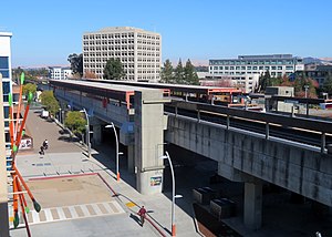
19th Street Oakland station is an underground Bay Area Rapid Transit (BART) station located under Broadway between 17th Street and 20th Street in the Uptown District of Oakland, California. It is a timed transfer point between northbound trains to Richmond and to Antioch. The station has three underground levels, with tracks on the second and third levels. It is served by the Red Line, Orange Line, and Yellow Line, as well as by AC Transit buses on the surface at the Uptown Transit Center.

<span class="mw-page-title-main">Fruitvale station</span> Rapid transit station in San Francisco Bay Area

Fruitvale station is a Bay Area Rapid Transit (BART) station located in the Fruitvale District of Oakland, California. The elevated station has two side platforms. The station is served by the Orange, Green, and Blue lines.

<span class="mw-page-title-main">Rockridge station</span> Metro station in Oakland, California, US

Rockridge station is a Bay Area Rapid Transit station located in the Rockridge district of Oakland, California. Located in the center median of the elevated State Route 24 west of the Caldecott Tunnel, the station has a single island platform serving two tracks. It is served by the Yellow Line.

<span class="mw-page-title-main">Orinda station</span> Rapid transit station in Orinda, California, US

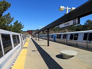
Orinda station is a Bay Area Rapid Transit station in Orinda, California. The station has an island platform in the center median of State Route 24. It is served by the Yellow Line. An abstract mural by Win Ng, partially covered by advertisements, is located in the fare lobby.

<span class="mw-page-title-main">Pleasant Hill/Contra Costa Centre station</span> Rapid transit station in California, US

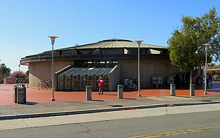
Pleasant Hill/Contra Costa Centre station is a Bay Area Rapid Transit (BART) station serving the Contra Costa Centre Transit Village in Contra Costa Centre, California, just north of Walnut Creek and just east of Pleasant Hill. It is served by the Yellow Line.

<span class="mw-page-title-main">Concord station (BART)</span> Rapid transit station in San Francisco Bay Area

Concord station is a Bay Area Rapid Transit (BART) station in Concord, California. The station is located between the downtown business district to the west and residential neighborhoods to the east. Concord station has a single elevated island platform and is served by the Yellow Line.

<span class="mw-page-title-main">San Leandro station</span> Rapid transit station in San Francisco Bay Area

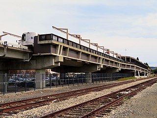
San Leandro station is a Bay Area Rapid Transit (BART) station located off Davis Street in downtown San Leandro, California. The station has two elevated side platforms, with the faregates at ground level. The station is served by the Orange, Green, and Blue lines.

<span class="mw-page-title-main">Bay Fair station</span> Rapid transit station in San Francisco Bay Area

Bay Fair station is a Bay Area Rapid Transit (BART) station located adjacent to the Bayfair Center mall in San Leandro, California. The station is served by the Orange, Green, and Blue lines.

<span class="mw-page-title-main">MacArthur station (BART)</span> Rapid transit station in San Francisco Bay Area

MacArthur station is a Bay Area Rapid Transit (BART) station in the Temescal District of Oakland, California. It is the largest station in the BART system, being the only one with four platform tracks. Service through MacArthur is timed for cross-platform transfers between the southbound lines that pass through the station. MacArthur station is located in the median of SR 24 just north of its interchange with I-580. The station is perpendicular to 40th Street and MacArthur Boulevard. The surrounding neighborhood is mostly low-density residential, making MacArthur station primarily a commuting hub.

<span class="mw-page-title-main">Union City station</span> Metro station in Union City, California, US

Union City station is a Bay Area Rapid Transit (BART) station in Union City, California. The station sits near Decoto Road east of Alvarado-Niles Road, directly behind the James Logan High School campus. The station is served by the Orange and Green lines. Local bus service is provided by Union City Transit and AC Transit.

<span class="mw-page-title-main">North Berkeley station</span> Metro station in Berkeley, California, US

North Berkeley station is an underground Bay Area Rapid Transit (BART) station located in the North Berkeley neighborhood of Berkeley, California. It is bounded by Virginia Street, Sacramento Street, Delaware Street, and Acton Street in a residential area north of University Avenue. The main station entrance sits within a circular building at the center of a parking lot, while an elevator between the surface and the platform is located at the parking lot's Sacramento Street edge. The station is served by the Orange and Red lines.

<span class="mw-page-title-main">Dublin/Pleasanton station</span> Rapid transit station in Pleasanton, California, US

Dublin/Pleasanton station is a Bay Area Rapid Transit (BART) station on the border of Dublin and Pleasanton in California. It is the eastern terminus of the Blue Line. It is also a major bus terminal served by six providers.

<span class="mw-page-title-main">Hayward station (BART)</span> Metro station in Hayward, California, US

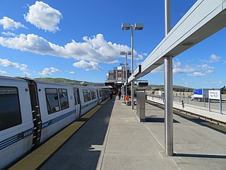
Hayward station is a Bay Area Rapid Transit (BART) station in Hayward, California, serving Downtown Hayward and the surrounding areas. It is served by the Orange and Green lines. The elevated station has two side platforms. A two-lane bus terminal is located on the northeast side of the station. A pedestrian tunnel under the Union Pacific Railroad Oakland Subdivision connects the fare lobby to a parking lot and a five-level parking garage.

<span class="mw-page-title-main">Pittsburg/Bay Point station</span> Rapid transit station in San Francisco Bay Area

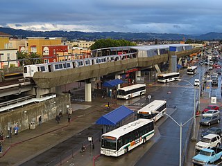
Pittsburg/Bay Point station is a Bay Area Rapid Transit station in Pittsburg, California, United States, adjacent to the community of Bay Point. It serves northern and eastern Contra Costa County, as well as the Sacramento–San Joaquin River Delta area. Passengers transfer between the light and heavy rail portions of the Yellow Line at a dedicated transfer platform east of the main station.

<span class="mw-page-title-main">El Cerrito del Norte station</span> Rapid transit station in San Francisco Bay Area

El Cerrito del Norte station is a Bay Area Rapid Transit (BART) station located on Cutting Boulevard in El Cerrito, California. The station is served by the Orange and Red lines. Located near San Pablo Avenue and Interstate 80, it serves as a regional transit hub for local AC Transit bus services, and for commuter feeder services from Solano, Napa, and Marin Counties in the North Bay plus western Contra Costa County. Opened in 1973, the station was renovated in 2017–2021 to add additional elevators, stairs, and lobby space.

<span class="mw-page-title-main">El Cerrito Plaza station</span> Rapid transit station in El Cerrito, California, US

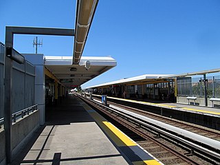
El Cerrito Plaza station is a Bay Area Rapid Transit (BART) station in El Cerrito, California, located adjacent to the El Cerrito Plaza shopping center. It primarily serves southern El Cerrito, northern Albany, and Kensington, along with nearby portions of Berkeley and Richmond. Nearly identical in form to El Cerrito del Norte station, El Cerrito Plaza station has two side platforms serving the line's two elevated tracks, with a fare lobby underneath. The Ohlone Greenway runs through the station area. The station is served by the Orange and Red lines.

<span class="mw-page-title-main">Oakland Coliseum station</span> Rail station in Oakland, California, US

The station complex of Amtrak's Oakland Coliseum station and Bay Area Rapid Transit (BART)'s Coliseum station is located in the East Oakland area of Oakland, California, United States. The two stations, located about 600 feet (180 m) apart, are connected to each other and to the Oakland Coliseum/Oakland Arena sports complex with an accessible pedestrian bridge. The BART station is served by the Orange, Green, and Blue lines; the Amtrak station is served by the Capitol Corridor service.

References

  1. Cerny, Susan Dinkelspiel (2007). An Architectural Guidebook to San Francisco and the Bay Area (1st ed.). Layton, UT: Gibbs Smith. pp. 501–502. ISBN   978-1-58685-432-4. OCLC   85623396.
  2. "Monthly Ridership Reports". San Francisco Bay Area Rapid Transit District. February 2024.
  3. 1 2 3 "Transit Stops: Walnut Creek Station". Metropolitan Transportation Commission. January 6, 2022.
  4. 1 2 3 4 "Walnut Creek Comprehensive Station Plan" (PDF). San Francisco Bay Area Rapid Transit District. June 2004. Archived from the original (PDF) on November 20, 2010.
  5. "Names Approved for 38 Rapid Transit Stations Around Bay". Oakland Tribune. December 10, 1965. p. 10 via Newspapers.com.
  6. "BART Chronology January 1947 – March 2009" (PDF). San Francisco Bay Area Rapid Transit District. March 2009. Archived from the original (PDF) on October 13, 2013.
  7. "Shuttle Bus Ceremony Tomorrow". Oakland Tribune. December 11, 1974. p. 15 via Newspapers.com.
  8. 2023–2028 Short Range Transit Plan (PDF). Central Contra Costa Transit Authority. December 15, 2022. p. 3.
  9. "Will extra miles dim the smiles of genial county service?". The San Francisco Examiner. June 1, 1982. p. 3 via Newspapers.com.
  10. "Earthquake Safety Program Construction Updates (archive)". San Francisco Bay Area Rapid Transit District. 2009.
  11. "Bay Area Rapid Transit Walnut Creek Station Modernization & TOD Access Improvements Project: Conceptual Station Plan" (PDF). San Francisco Bay Area Rapid Transit District. May 1, 2019.
  12. "New Fare Gates & Station Hardening". San Francisco Bay Area Rapid Transit District. July 2023. Archived from the original on September 4, 2023.
  13. Klein, Harper (April 2, 2023). "Pivotal Moments In History: The Golden Triangle and Measure A". Walnut Creek Magazine. Retrieved April 29, 2024.
  14. 1 2 "Transit-Oriented Development (TOD) - Walnut Creek". San Francisco Bay Area Rapid Transit District. 2023. Retrieved April 29, 2024.
  15. Nardi, Elisabeth (October 24, 2014). "Walnut Creek: BART Transit Village parking garage approved, construction likely to start soon". The Mercury News. Archived from the original on April 27, 2017.
  16. "New parking garage construction on the south lot at Walnut Creek Station begins" (Press release). San Francisco Bay Area Rapid Transit District. January 30, 2018.
  17. "New South Garage at Walnut Creek Station opens 3/29" (Press release). San Francisco Bay Area Rapid Transit District. March 18, 2019.
  18. "New development construction adjacent to Walnut Creek Station" (Press release). San Francisco Bay Area Rapid Transit District. August 14, 2019.
  19. "Walnut Creek Station: new vehicle entrance to open on November 10" (Press release). San Francisco Bay Area Rapid Transit District. November 1, 2022.

Commons-logo.svg Media related to Walnut Creek station at Wikimedia Commons