The Mill River is a river in New Haven County, Connecticut, United States. [1]
Contents


The Mill River is a river in New Haven County, Connecticut, United States. [1]
A mill for grinding corn was built on a Quinnipiack ford near East Rock in 1642. By 1780 there were eight mills. In time the river provided power for Eli Whitney's gun factory, now the Eli Whitney Museum. It joins the Quinnipiac River at the mouth of New Haven Harbor which opens out into Long Island Sound.
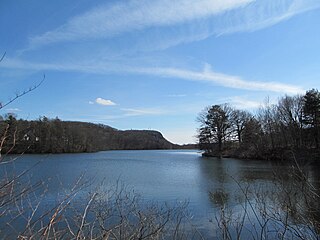
The river starts in the town of Cheshire, flows through Hamden and New Haven, and discharges into New Haven Harbor on Long Island Sound. The upper portion of the river is formed from eastern and western branches, the latter of which is sometimes called Willow Brook. The river's length is 17.4 miles (28.0 km). [2] The river is dammed in southern Hamden to form Lake Whitney, which is operated as a reservoir by the South Central Connecticut Regional Water Authority.
Mill River passes through Sleeping Giant State Park in northern Hamden and East Rock Park below Lake Whitney in Hamden. These are among the river's reaches that remain undeveloped and are popular spots for fishing and hiking.
The USGS has maintained a gauge (01196620) near Sleeping Giant for the past 41 year to continuously monitor flow. Real time data are available here.
A trail is under development that follows the course of the river, especially in the city of New Haven.
The lower portion of the river is a fresh tidal system because of the existence of tide gates that cyclically block flow near State Street in New Haven. This section of the river is the subject of research to determine how sediments, metals, and other substances cycle through the estuary.

English Station, an abandoned power plant, lies on Ball Island in the New Haven terminus of the river. There has been a study of PAHs in this section of the river.
In 2018 a plan for protecting and restoring the Mill River Watershed was developed through collaboration between Save the Sound and Connecticut DEEP. [3]
The river and its watershed are stewarded by a volunteer group, the Mill River Watershed Association.
In July 2020, 2.1 million gallons of raw sewage spilled into the Mill River when a corroded sewage pipe broke. Within a week the broken pipe was replaced and city officials announced water samples from the river showed safe levels of bacteria. [4]

Hamden is a town in New Haven County, Connecticut, United States. The town's nickname is "The Land of the Sleeping Giant". The town is part of the South Central Connecticut Planning Region. The population was 61,169 at the 2020 census.

Long Island Sound is a marine sound and tidal estuary of the Atlantic Ocean. It lies predominantly between the U.S. state of Connecticut to the north and Long Island in New York to the south. From west to east, the sound stretches 110 mi (180 km) from the East River in New York City, along the North Shore of Long Island, to Block Island Sound. A mix of freshwater from tributaries, and saltwater from the Atlantic Ocean, Long Island Sound is 21 mi (34 km) at its widest point and varies in depth from 65 to 230 feet.

The Calumet River is a system of heavily industrialized rivers and canals in the region between the south side of Chicago, Illinois, and the city of Gary, Indiana. Historically, the Little Calumet River and the Grand Calumet River were one, the former flowing west from Indiana into Illinois, then turning back east to its mouth at Lake Michigan at Marquette Park in Gary. Now the system is part of the Chicago Area Waterway System and through the use of locks flows away from Lake Michigan to the Cal-Sag Channel.

The Quinnipiac River is a 45.5-mile (73.2 km) long river in the New England region of the United States, located entirely in the state of Connecticut.
East Rock of south-central Connecticut, United States, with a high point of 366 feet (112 m), is a 1.4-mile (2 km) long trap rock ridge located primarily in the neighborhood of East Rock on the north side of the city of New Haven. A prominent landscape feature and a popular outdoor recreation area with cliffs that rise 300 feet (91 m) over the city below, East Rock is part of the narrow, linear Metacomet Ridge that extends from Long Island Sound near New Haven, north through the Connecticut River Valley of Massachusetts to the Vermont border. East Rock is the central feature of East Rock Park, a municipal park owned by the city of New Haven along the New Haven-Hamden town line.

Sleeping Giant, , is a rugged traprock mountain with a high point of 739 feet (225 m), located eight miles (13 km) north of New Haven, Connecticut. A prominent landscape feature visible for miles, the Sleeping Giant receives its name from its anthropomorphic resemblance to a slumbering human figure as seen from either the north or south. The Giant is known for its expansive clifftop vistas, rugged topography, and microclimate ecosystems. Most of the Giant is located within Sleeping Giant State Park. The mountain is a popular recreation site: over 30 miles (48 km) of hiking trails traverse it including 5 miles (8 km) of the 23-mile (37 km) Quinnipiac Trail. Quinnipiac University is located at Mount Carmel's foot in Hamden.

Regicides Trail is a Blue-Blazed hiking trail, about 7 miles (11 km) long, roughly following the edge of a diabase, or traprock, cliff northwest of New Haven, Connecticut. It is named for two regicides, Edward Whalley and his son-in-law William Goffe, who signed the death warrant of King Charles I of England. Upon the restoration of Charles II to the throne and the persecution of the regicides, the pair hid in Judges Cave near the south end of the trail in 1660. The Regicides is widely known to be one of the most technical trails within the CT Blue-Blazed trail system.

The Eli Whitney Museum, in Hamden, Connecticut, is an experimental learning workshop for students, teachers, and families. The museum's main building is located on a portion of the Eli Whitney Gun Factory site, a gun factory erected by Eli Whitney in 1798. The museum focuses on teaching experiments that are the roots of design and invention, featuring hands-on building projects and exhibits on Whitney and A. C. Gilbert.

The Mianus River is a 20.3-mile-long (32.7 km) river in Westchester County, New York, and Fairfield County, Connecticut, in the United States. It begins in the town of North Castle, New York in a series of ponds at about 600 feet (180 m) altitude. Flowing northeast into the town of Bedford, it abruptly turns south and passes through the Mianus River Gorge, a nature preserve, before entering Stamford, Connecticut, where it is dammed into the Mianus Reservoir, officially known as the Samuel J. Bargh Reservoir of the Greenwich Water Company. From there, it flows south through Stamford and Greenwich into Long Island Sound, at sea level.

The Norwalk River is a river in southwestern Connecticut, United States, approximately 21 miles (34 km) long. The word "Norwalk" comes from the Algonquian word "noyank" meaning "point of land".
Lake Whitney is a lake in Hamden, Connecticut, that is a part of the Mill River. The lake was a water source for the New Haven, Connecticut, metro area, until its associated treatment plant became antiquated in the 1990s. A new water treatment facility was constructed in the early 2000s rated for up to 15 million gallons per day. Lake Whitney now serves as one of four primary sources of surface water for the RWASouth Central Connecticut Regional Water Authority. RWA also operates a gravity release from the dam when there is no flow over the spillway, and operates an "Eel Pass" in conjunction with CT DEEP to assist with eel migration over the dam.
East Rock Park is a park in the city of New Haven and the town of Hamden, Connecticut that is operated as a New Haven city park. The park surrounds and includes the mountainous ridge named East Rock and was developed with naturalistic landscaping. The entire 427-acre (173 ha) park is listed on the National Register of Historic Places.

Whitneyville is a neighborhood in the southeastern portion of the town of Hamden, Connecticut. It started in the early nineteenth century as a factory town for workers in Eli Whitney's gun factory. Around the turn of the twentieth century, it evolved into a trolley suburb of New Haven. Today it is primarily residential, with a mixture of single-family homes and small apartment and condominium buildings. There is some commercial development centered around the intersection of Whitney and Putnam avenues.

West Rock Ridge State Park is a public recreation area located in New Haven, Hamden, and Woodbridge, Connecticut. The state park is named for the 400-to-700-foot trap rock West Rock Ridge, which is part of the Metacomet Ridge extending from Long Island Sound to the Vermont border. The park's 7 miles (11 km) of open west-facing cliffs offer vistas encompassing Metropolitan New Haven and suburban towns to the west. The park includes Judges Cave, a colonial era historic site; Lake Wintergreen; and the 7-mile (11 km) Regicides Trail, part of the Connecticut Forest and Park Association's Blue Trail system. The park is part of a larger area of protected open space including state, municipal, and non-profit owned land.
The Quinnipiac Trail is a 24-mile (39 km) Blue-Blazed hiking trail in New Haven County, Connecticut. It is the product of the evolution and growth of the first 10.6-mile (17.1 km) trail designated in Connecticut's Blue-Blazed Hiking Trail system, with its light-blue rectangular vertical painted blazes.

West Rock Ridge or West Rock of south-central Connecticut, is a 7-mile (11 km) long trap rock mountain ridge located on the west side of New Haven with a high point of 700 feet (213 m) at High Rock, also known as York Mountain. The ridge forms a continuous line of exposed cliffs visible from metropolitan New Haven and points west. West Rock Ridge is part of the narrow, linear Metacomet Ridge which extends from Long Island Sound near New Haven north through the Connecticut River Valley of Massachusetts to the Vermont border.

The Pequonnock River is a 16.7-mile-long (26.9 km) waterway in eastern Fairfield County, Connecticut. Its watershed is located in five communities, with the majority of it located within Monroe, Trumbull, and Bridgeport. The river has a penchant for flooding, particularly in spring since the removal of a retention dam in Trumbull in the 1950s. There seems to be a sharp difference of opinion among historians as to just what the Indian word Pequonnock signifies. Some insist it meant cleared field or open ground; others are sure it meant broken ground; while a third group is certain it meant place of slaughter or place of destruction.
Whitney Avenue is a principal arterial connecting Downtown New Haven with the town center of Hamden in the U.S. state of Connecticut. Most of the road within the city of New Haven is included in the Whitney Avenue Historic District, which is listed on the National Register of Historic Places. The designation begins at Grove Street in the northern part of Downtown New Haven and extends through the town of Hamden up to the Cheshire town line. North of Dixwell Avenue in Hamden Center, the road is a state highway and designated as part of Route 10. From the New Haven town line to Dixwell Avenue, the road is state-maintained with an unsigned designation of State Road 707. Within New Haven, Whitney Avenue is a town road. The J route of Connecticut Transit New Haven, which connects New Haven to Waterbury, runs along Whitney Avenue.
The South Central Connecticut Regional WaterAuthority is a public water supply utility in Connecticut, United States. The RWA supplies water in a 15-town region with a population of about 430,000. The RWA acts as a steward of the environment in the local region by protecting more than 26,000 acres of watershed lands, and promoting sustainability.

Whetstone Brook is a tributary of the Connecticut River that runs through the heart of Brattleboro, Vermont, in the United States. It flows into the Connecticut at an elevation of 250 feet (76 m) above sea level. The headwater for the brook is at Hidden Lake, which is 1,500 feet (460 m) above sea level in the town of Marlboro. Of the 28-square-mile (73 km2) watershed, over two thirds is contained within Brattleboro, while another 30 percent is in Marlboro. The remaining 2% is within the town of Dummerston. The brook is crossed by Creamery Covered Bridge in West Brattleboro, which was built in 1879. The original Abenaki name for the waterway is Kitadowôganisibosis.
41°25′15″N72°54′12″W / 41.42083°N 72.90333°W