Fairfield County is a county in the southwestern corner of the U.S. state of Connecticut. It is the most populous county in the state and was also its fastest-growing from 2010 to 2020. As of the 2020 census, the county's population was 957,419, representing 26.6% of Connecticut's overall population. The closest to the center of the New York metropolitan area, the county contains four of the state's top 7 largest cities—Bridgeport (1st), Stamford (2nd), Norwalk (6th), and Danbury (7th)—whose combined population of 433,368 is nearly half the county's total population.

The Saugatuck River is a 23.7-mile-long (38.1 km) river in southwestern Connecticut in the United States. It drains part of suburban and rural Fairfield County west of Bridgeport, emptying into Long Island Sound.

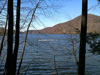
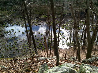
The Saugatuck Reservoir is a reservoir in Fairfield County, Connecticut, United States, that straddles the border between the towns of Redding, Weston, and Easton. Its completion is marked by the creation of the Samuel P. Senior dam of the Saugatuck River in January 1942, and provides water to several of the nearby towns. The reservoir is surrounded by the Centennial Watershed State Forest and a small section of the Trout Brook Valley State Park Reserve on the southeast end of the reservoir. The Saugatuck Reservoir utilizes an uncontrolled spillway adjacent to the Samuel P. Senior dam that effectively limits the maximum water level. There is also a concrete levee positioned on the southeastern side of the reservoir that prevents water from flooding Trout Brook Valley.

Connecticut's 4th congressional district is a congressional district in the U.S. state of Connecticut. Located in the southwestern part of the state, the district is largely suburban and extends from Bridgeport, the largest city in the state, to Greenwich – an area largely coextensive with the Connecticut side of the New York metropolitan area. The district also extends inland, toward Danbury and toward the Lower Naugatuck Valley.
Nichols, a historic village in southeastern Trumbull in Fairfield County, Connecticut, is named after the family who maintained a large farm in its center for almost 300 years. The Nichols Farms Historic District, which encompasses part of the village, is listed on the National Register of Historic Places. Originally home to the Golden Hill Paugussett Indian Nation, the area was colonized by the English during the Great Migration of the 1630s as a part of the coastal settlement of Stratford. The construction of the Merritt Parkway through the village, and the subsequent closing of stores and factories, turned the village into a bedroom community in 1939. Aviation pioneer Igor Sikorsky lived in three separate homes in Nichols during his active years between 1928 and 1951, when he designed, built and flew fixed-wing aircraft and put the helicopter into mass production for the first time.

Gregory's Four Corners Burial Ground, a cemetery established in Trumbull, Connecticut in 1761, is located on Spring Hill Road near the Monroe town line and is maintained by the Trumbull Parks Commission.
Ash Creek is a tidal creek and intertidal wetland in Fairfield County, Connecticut that serves as a border between the city of Bridgeport and the town of Fairfield. It is the last salt water estuary in the area, extending from Long Island Sound and up the Rooster River.

The Pequonnock River is a 16.7-mile-long (26.9 km) waterway in eastern Fairfield County, Connecticut. Its watershed is located in five communities, with the majority of it located within Monroe, Trumbull, and Bridgeport. The river has a penchant for flooding, particularly in spring since the removal of a retention dam in Trumbull in the 1950s. There seems to be a sharp difference of opinion among historians as to just what the Indian word Pequonnock signifies. Some insist it meant cleared field or open ground; others are sure it meant broken ground; while a third group is certain it meant place of slaughter or place of destruction.
The Aspetuck Valley Trail is a 5.9-mile (9.5 km) Blue-Blazed hiking trail in the Aspetuck River Valley area of Fairfield County in the towns of Newtown, Easton and Redding Connecticut.
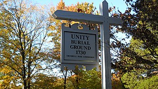
The Unity Burial Ground is a small graveyard located on the southeast end of White Plain in the Nichols section of Trumbull, Connecticut. It is located a few rods north of the site of the first meeting house that was built in the parish of Unity, off of White Plains Road. The cemetery was laid out in 1730 and the first burial was that of 7 year old Samuel Bennitt on June 21, 1731. There are over 110 gravestones, 90 unmarked field stones and 241 known grave sites, and most of the original stones face east. This is unusual, as it runs contrary to the common practice of placing stones so that they face the road. The latest known burial was for Charles E Booth Jr. on August 17, 1935.
Stepney, also referred to as Stepney Village and Upper Stepney, is a district of the town of Monroe, Connecticut, and on the Connecticut State Register of Historic Places. Consisting of approximately 8 square miles (21 km2), Stepney extends from the Trumbull town line, along Route 25, to the Newtown town line. It was listed as a census-designated place prior to the 2020 census.

Long Hill is a village/neighborhood and census-designated place (CDP) in the town of Trumbull in Fairfield County, Connecticut, United States. It is located west of the Pequonnock River. The main thoroughfare is Connecticut Route 111, present-day Main Street. It was listed as a census-designated place prior to the 2020 census.
St. Catherine of Siena is a Roman Catholic parish in Trumbull, Connecticut, part of the Diocese of Bridgeport.

The Zachariah Curtiss House is located at 2950 Nichols Avenue on the east side of the Farm Highway or Route 108 on the south side of Mischa Hill, in the village of Nichols in Trumbull, Connecticut in New England. The house was built by Zachariah II between 1721 and 1746 in the Georgian architectural style. The Colonial American wooden post-and-beam timber frame farm house has a one and one-half story ell added in 1800. The house has the distinction of being located in four different townships in its history, but has never been moved; Stratford (1686–1725), Unity (1725–1744), North Stratford (1744–1797) and Trumbull (1797-present). It is currently in a dilapidated state awaiting demolition.
The Ritz Ballroom was a popular cabaret, jazz, and swing nightclub located in the Black Rock neighborhood of Bridgeport, Connecticut near Ash Creek.

Bridgeport, Connecticut is a major city of Connecticut located on Long Island Sound at the mouth of the Pequonnock River.

Fairchild Wheeler Interdistrict Multi-Magnet High School is a magnet high school located in Bridgeport, Connecticut. It has an enrollment of approximately 1500 students in grades 9 through 12.