
Mount Charleston, including Charleston Peak at 11,916 feet (3,632 m), is the highest mountain in both the Spring Mountains and Clark County, in Nevada, United States. It is the eighth-highest mountain in the state. Well separated from higher peaks by large, low basins, Charleston Peak is the most topographically prominent peak in Nevada, and the eighth-most-prominent peak in the contiguous United States. It is one of eight ultra-prominent peaks in Nevada. It is located about 35 miles (56 km) northwest of Las Vegas within the Mount Charleston Wilderness, which is within the Spring Mountains National Recreation Area of the Humboldt–Toiyabe National Forest.

Wheeler Peak is the tallest mountain in the Snake Range and in White Pine County, in Nevada, United States. The summit elevation of 13,065 feet (3,982 m) makes it the second-highest peak in Nevada, just behind Boundary Peak. With a topographic prominence of 7,563 feet (2,305 m), Wheeler Peak is the most topographically prominent peak in White Pine County and the second-most prominent peak in Nevada, just behind Mount Charleston. The mountain is located in Great Basin National Park and was named for George Wheeler, leader of the Wheeler Survey of the late 19th century.

Mount Humphreys is a mountain peak in the Sierra Nevada on the Fresno-Inyo county line in the U.S. state of California. It is the 14th highest peak in California, and the highest peak in the Bishop area. The mountain was named by the California Geological Survey of 1873 for Andrew A. Humphreys, the chief engineer of the United States Army at the time.

The Jarbidge Wilderness is a wilderness area located in the Jarbidge Mountains of northern Elko County in northeastern Nevada, United States. It is contained within the Jarbidge Ranger District of the Humboldt-Toiyabe National Forest.
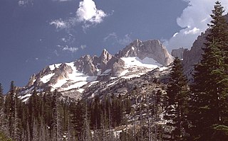
Matterhorn Peak is located in the Sierra Nevada, in the western U.S. state of California, at the northern boundary of Yosemite National Park. At 12,285 feet (3,744 m) elevation, it is the tallest peak in the craggy Alps-like Sawtooth Ridge and the northernmost 12,000-foot (3,700 m) peak in the Sierra Nevada. The peak also supports the Sierra's northernmost glacier system. It was named after the Matterhorn in the Alps. Matterhorn Peak is quite near to Twin Peaks, and just north of Whorl Mountain.

The Jarbidge Mountains are a mountain range in northern Elko County, Nevada, United States. The range includes multiple sub-ranges, including the Bruneau Range, Buck Creek Mountains, Copper Mountains, Elk Mountains, Fox Creek Range, Ichabod Range, Marys River Range, Salmon River Range and Wild Horse Range. The central core of the range, including most of the peaks above 10,500 feet (3,200 m), extends southward approximately 5 miles (8 km) from a point near the small community of Jarbidge.

Pilot Peak is the highest mountain in the Pilot Range in extreme eastern Elko County, Nevada, United States. It is the most topographically prominent peak in Elko County and the fourth-most prominent peak in Nevada. The peak is on public land administered by the Bureau of Land Management and thus has no access restrictions.

Thomas Peak is the second highest named mountain in both the Ruby Mountains and Elko County, in Nevada, United States. It is the thirty-fourth highest mountain in the state. The peak is located about 24 miles (39 km) southeast of the city of Elko in the Ruby Mountains Wilderness, within the Ruby Mountains Ranger District of the Humboldt-Toiyabe National Forest. One of the most voluminous mountains in the range, its base makes up most of the east wall of Thomas Canyon, as well as the west wall of the long curved section of upper Lamoille Canyon.

Arc Dome is the highest mountain of the Toiyabe Range in northwestern Nye County, Nevada, United States. It is the thirteenth-highest mountain in the state. Arc Dome also ranks as the second-most topographically prominent peak in Nye County and the eighth-most prominent peak in the state. The peak is located about 53 miles (85 km) north of the community of Tonopah, within the Arc Dome Wilderness of the Humboldt-Toiyabe National Forest.

Mount Jefferson is the highest mountain in both the Toquima Range and Nye County in Nevada, United States. It is the sixth highest mountain in the state. As the high point of a range which is well separated from other ranges by low basins, Mount Jefferson has a high topographic prominence of 5,861 feet (1,786 m). This makes it the most prominent peak in Nye County and the third most prominent peak in Nevada. For similar reasons, it is also the highest mountain for over 90 miles in all directions. It is located about 50 miles (80 km) northeast of the county seat of Tonopah within the Alta Toquima Wilderness of the Humboldt-Toiyabe National Forest, near the smaller towns of Carvers and Round Mountain. Three distinct summits are located on a broad area of subalpine tundra: North Summit rises to 11,820 feet (3,603 m), Middle Summit to 11,692 feet (3,564 m), and South Summit to 11,949 feet (3,642 m). During the Pleistocene, alpine glaciers eroded several cirques east of the summit plateau.
The Copper Mountains are a mountain range in Elko County, Nevada, United States.

Sacajawea Peak is a peak in the Wallowa Mountains, in the U.S. state of Oregon. It is in the Eagle Cap Wilderness and the Wallowa–Whitman National Forest.
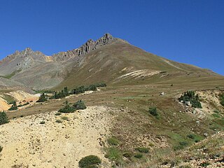
Matterhorn Peak is a high mountain summit in the San Juan Mountains range of the Rocky Mountains of North America. The 13,596-foot (4,144 m) thirteener is located in the Uncompahgre Wilderness of Uncompahgre National Forest, 10.3 miles (16.6 km) west by north of the Town of Lake City in Hinsdale County, Colorado, United States.

The Jarbidge Ranger District is a 243,907-acre (98,706 ha) ranger district within the Humboldt-Toiyabe National Forest. It is located in northern Elko County, Nevada, United States, directly adjacent to the Mountain City Ranger District. The town of Jarbidge is contained within the district.
Coon Creek Peak is a mountain in northern Elko County, Nevada, about 4 miles southwest of the community of Jarbidge. It is considered to be the most northeasterly peak of the Copper Mountains. Located a few miles west of the main crest of the Jarbidge Mountains, it is located within the Jarbidge Ranger District of the Humboldt-Toiyabe National Forest. The main road entering Jarbidge from the south, Charleston-Jarbidge Road, runs along the western slopes of the mountain as it travels between Coon Creek Summit and Bear Creek Summit, providing close vehicular access to the summit of Coon Creek Peak.

McAfee Peak is the highest mountain in the Independence Mountains of northern Elko County, Nevada, United States. It ranks twenty-first among the most topographically prominent peaks in the state. The peak is located within the Mountain City Ranger District of the Humboldt-Toiyabe National Forest.

Marys River Peak is the highest mountain in the Marys River Range of northern Elko County, Nevada, United States. It is located within the Jarbidge Wilderness, which is administered by the Jarbidge Ranger District of the Humboldt-Toiyabe National Forest. The peak's name is derived from the Marys River, a tributary of the Humboldt.

Jarbidge Peak is the second highest mountain in the Jarbidge Mountains of northern Elko County, Nevada, United States. It is located within the Jarbidge Ranger District of the Humboldt-Toiyabe National Forest. The boundary of the Jarbidge Wilderness crosses the peak.

Star Peak is both the highest and most topographically prominent mountain in both the Humboldt Range and Pershing County in Nevada, United States. It is the sixth-most topographically prominent peak in Nevada. The peak is on public land administered by the Bureau of Land Management and has no access restrictions.


