The place was originally called Wi:kidoʼyoʼ in Yavapai.[3] A local legend holds that the English name came from a runaway boy with the last name of Mayer.[citation needed] From May to June 1942, 245 Japanese Americans were confined at the Mayer Assembly Center, one of 17 temporary detention camps built to hold Japanese Americans removed from the West Coast after the U.S. entered World War II. The 69 families were mostly from Maricopa County's Salt River Valley area, and lived in military-style barracks on the converted Civilian Conservation Corps camp for just under a month before being transferred to the more permanent and isolated internment camp at Poston, Arizona.[4]
The Goodwin Fire sparked on June 24, 2017, in the Bradshaw Mountains near the town of Mayer, which days later led to the evacuations of more than 9,000 residents. The wildfire burned 28,516 acres of land. Highway 69 was closed between the towns of Mayer and Dewey-Humboldt. The fire destroyed approximately five structures and injured one firefighter.[5][6]
Geography
According to the United States Census Bureau, the CDP has a total area of 20.1 square miles (52km2), all land.
At the 2000 census there were 1,408 people, 585 households, and 379 families living in the CDP. The population density was 70.2 inhabitants per square mile (27.1/km2). There were 714 housing units at an average density of 35.6 per square mile (13.7/km2). The racial makeup of the CDP was 94% White, 1% Native American, 3% from other races, and 2% from two or more races. 9% of the population were Hispanic or Latino of any race.[9] Of the 585 households 26% had children under the age of 18 living with them, 52% were married couples living together, 8% had a female householder with no husband present, and 35% were non-families. 28% of households were one person and 13% were one person aged 65 or older. The average household size was 2.4 and the average family size was 2.9.
The age distribution was 24% under the age of 18, 6% from 18 to 24, 23% from 25 to 44, 28% from 45 to 64, and 19% 65 or older. The median age was 44 years. For every 100 females, there were 99.2 males. For every 100 females age 18 and over, there were 97.6 males.
The median household income was $28,412 and the median family income was $33,988. Males had a median income of $38,304 versus $21,417 for females. The per capita income for the CDP was $14,297. About 14% of families and 19% of the population were below the poverty line, including 13% of those under age 18 and 17% of those age 65 or over.
This page is based on this Wikipedia article Text is available under the CC BY-SA 4.0 license; additional terms may apply. Images, videos and audio are available under their respective licenses.


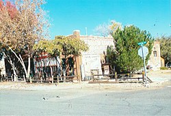 Historic Mayer Business Block.
 Rear view of the Mayer General Market Store.
 Mayer Apartment #1.
 Mayer Apartment #2.
 Mayer Red Brick Schoolhouse.