Mayville, Michigan

Last updated

Mayville, Michigan
Tuscola County Michigan Incorporated and Unincorporated areas Mayville Highlighted.svg
Location of Mayville, Michigan
Coordinates: 43°20′10″N83°21′3″W / 43.33611°N 83.35083°W / 43.33611; -83.35083
Country United States
State Michigan
County Tuscola
Area
[1]
  Total1.10 sq mi (2.84 km2)
  Land1.08 sq mi (2.79 km2)
  Water0.02 sq mi (0.05 km2)
Elevation
912 ft (278 m)
Population
 (2020)
  Total922
  Density856.08/sq mi (330.49/km2)
Time zone UTC-5 (Eastern (EST))
  Summer (DST) UTC-4 (EDT)
ZIP code
48744
Area code 989
FIPS code 26-52540 [2]
GNIS feature ID0631783 [3]
Website www.villageofmayville.net

Mayville is a village in Tuscola County, in the U.S. state of Michigan. The population was 948 at the 2010 census. The village is within Fremont Township along the boundary with Dayton Township.

Contents

Geography

According to the United States Census Bureau, the village has a total area of 1.15 square miles (2.98 km2), of which 1.13 square miles (2.93 km2) is land and 0.02 square miles (0.05 km2) is water. [4] Mayville is home to one public school system, grades K-12, the 'Mayville Wildcats' include students from the nearby towns of Silverwood and Fostoria. The village was founded in 1865 by Dexter Choat.

Demographics

Historical population
CensusPop.Note
1880 248
1890 728193.5%
1900 82513.3%
1910 687−16.7%
1920 652−5.1%
1930 6540.3%
1940 73612.5%
1950 88820.7%
1960 8960.9%
1970 872−2.7%
1980 9589.9%
1990 1,0105.4%
2000 1,0554.5%
2010 950−10.0%
2020 922−2.9%
U.S. Decennial Census [5]

In 2010 Mayville was awarded an energy improvement grant by the U.S. Department of Energy. A total of 43 grants were distributed under the American Recovery and Reinvestment Act to improve the nation's energy security.

2010 census

As of the census [6] of 2010, there were 950 people, 369 households, and 235 families living in the village. The population density was 840.7 inhabitants per square mile (324.6/km2). There were 432 housing units at an average density of 382.3 per square mile (147.6/km2). The racial makeup of the village was 96.1% White, 0.5% African American, 0.2% Native American, 0.2% Asian, 0.5% from other races, and 2.4% from two or more races. Hispanic or Latino of any race were 2.5% of the population.

There were 369 households, of which 33.6% had children under the age of 18 living with them, 43.9% were married couples living together, 13.3% had a female householder with no husband present, 6.5% had a male householder with no wife present, and 36.3% were non-families. 32.0% of all households were made up of individuals, and 12.7% had someone living alone who was 65 years of age or older. The average household size was 2.43 and the average family size was 3.05.

The median age in the village was 41.1 years. 25.4% of residents were under the age of 18; 7.4% were between the ages of 18 and 24; 21.9% were from 25 to 44; 25% were from 45 to 64; and 20.1% were 65 years of age or older. The gender makeup of the village was 47.4% male and 52.6% female.

2000 census

As of the census [2] of 2000, there were 1,055 people, 402 households, and 281 families living in the village. The population density was 1,028.9 inhabitants per square mile (397.3/km2). There were 424 housing units at an average density of 413.5 per square mile (159.7/km2). The racial makeup of the village was 97.73% White, 0.47% African American, 0.19% Asian, and 1.61% from two or more races. Hispanic or Latino of any race were 1.14% of the population.

There were 402 households, out of which 35.1% had children under the age of 18 living with them, 52.2% were married couples living together, 13.7% had a female householder with no husband present, and 29.9% were non-families. 25.4% of all households were made up of individuals, and 10.0% had someone living alone who was 65 years of age or older. The average household size was 2.62 and the average family size was 3.16.

In the village, the population was spread out, with 28.2% under the age of 18, 12.4% from 18 to 24, 26.5% from 25 to 44, 20.1% from 45 to 64, and 12.7% who were 65 years of age or older. The median age was 32 years. For every 100 females, there were 93.6 males. For every 100 females age 18 and over, there were 90.7 males.

The median income for a household in the village was $33,375, and the median income for a family was $37,917. Males had a median income of $34,286 versus $21,111 for females. The per capita income for the village was $15,281. About 10.1% of families and 11.3% of the population were below the poverty line, including 12.6% of those under age 18 and 6.9% of those age 65 or over.

Climate

This climatic region has large seasonal temperature differences, with warm to hot (and often humid) summers and cold (sometimes severely cold) winters. According to the Köppen Climate Classification system, Mayville has a humid continental climate, abbreviated "Dfb" on climate maps. [7]

Climate data for Mayville, Michigan
MonthJanFebMarAprMayJunJulAugSepOctNovDecYear
Mean daily maximum °C (°F)−1
(30)
0
(32)
6
(43)
14
(58)
21
(70)
27
(80)
29
(84)
27
(81)
23
(74)
17
(62)
8
(47)
1
(34)
14
(58)
Mean daily minimum °C (°F)−10
(14)
−9
(16)
−4
(24)
1
(34)
7
(44)
12
(53)
14
(58)
13
(56)
9
(49)
4
(39)
−2
(29)
−7
(20)
2
(36)
Average precipitation mm (inches)43
(1.7)
33
(1.3)
51
(2)
71
(2.8)
71
(2.8)
84
(3.3)
79
(3.1)
76
(3)
89
(3.5)
66
(2.6)
64
(2.5)
48
(1.9)
770
(30.5)
Source: Weatherbase [8]

Related Research Articles

<span class="mw-page-title-main">Bienville, Louisiana</span> Village in Louisiana, United States

Bienville is a village in Bienville Parish, Louisiana, United States. The population was 218 at the 2010 census.

<span class="mw-page-title-main">Rich Township, Michigan</span> Civil township in Michigan, United States

Rich Township is a civil township of Lapeer County in the U.S. state of Michigan. The population was 1,500 at the 2020 Census.

Fremont Township is a civil township of Tuscola County in the U.S. state of Michigan. The population was 3,167 at the 2020 census.

Watertown Township is a civil township of Tuscola County in the U.S. state of Michigan. The population was 2,091 at the 2020 census.

Mayville Township is a township in Houston County, Minnesota, United States. The population was 427 at the 2000 census.

<span class="mw-page-title-main">Arrow Point, Missouri</span> Village in Missouri, United States

Arrow Point is a village in White River Township of southeast Barry County, Missouri, United States. The population was 75 at the 2020 census.

<span class="mw-page-title-main">St. Martins, Missouri</span> City in Missouri, United States

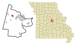
St. Martins or Saint Martins is a city in Cole County, Missouri, United States. The population was 1,191 at the 2020 census. It is part of the Jefferson City, Missouri Metropolitan Statistical Area.

<span class="mw-page-title-main">Pasadena Park, Missouri</span> Village in Missouri, United States

Pasadena Park is a village in St. Louis County, Missouri, United States. The population was 470 at the 2010 census. It is part of the Normandy School District, and is distinct from the city of Pasadena Hills.

<span class="mw-page-title-main">Mayville, North Dakota</span> City in North Dakota, United States

Mayville is a city in Traill County, North Dakota, United States. The population was 1,854 at the 2020 census. which makes Mayville the largest community in Traill County. Mayville was founded in 1881. The city's name remembers May Arnold, the first white child born in the immediate area.

<span class="mw-page-title-main">Portland, North Dakota</span> City in North Dakota, United States

Portland is a city in Traill County, North Dakota, United States. The population was 578 at the 2020 census.

<span class="mw-page-title-main">Mayville, Clark County, Wisconsin</span> Town in Wisconsin, United States

Mayville is a town in Clark County in the U.S. state of Wisconsin. The population was 919 at the 2000 census.

<span class="mw-page-title-main">Mount Sterling, Wisconsin</span> Village in Wisconsin, United States

Mount Sterling is a village in Crawford County, Wisconsin, United States. The population was 211 at the 2010 census.

<span class="mw-page-title-main">Kekoskee, Wisconsin</span> Village in Wisconsin, United States

Kekoskee is a village in Dodge County, Wisconsin, United States. The population was 161 at the 2010 census.

<span class="mw-page-title-main">Mayville, Wisconsin</span> City in Wisconsin, United States

Mayville is a city in Dodge County, Wisconsin, United States, located along the Rock River and the Horicon Marsh. The population was 5,154 at the 2010 census.

<span class="mw-page-title-main">Neosho, Wisconsin</span> Village in Wisconsin, United States

Neosho is a village in Dodge County, Wisconsin, United States. The population was 574 at the 2010 census.

<span class="mw-page-title-main">Blue River, Wisconsin</span> Village in Wisconsin, United States

Blue River is a village in Grant County, Wisconsin, United States. The population was 434 at the 2010 census.

<span class="mw-page-title-main">Cecil, Wisconsin</span> Village in Wisconsin, United States

Cecil is a village in Shawano County, Wisconsin, United States. The population was 529 at the 2020 census.

<span class="mw-page-title-main">Nashotah, Wisconsin</span> Village in Wisconsin, United States

Nashotah is a village in Waukesha County, Wisconsin, United States. The population was 1,321 at the 2020 census. The village took its name from the nearby Nashotah Lakes.

<span class="mw-page-title-main">Genoa, Wisconsin</span> Village in Wisconsin, United States

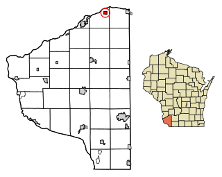
Genoa is a village in Vernon County, Wisconsin, United States. The population was 232 at the 2020 census. The village is within the Town of Genoa.

<span class="mw-page-title-main">Madawaska (CDP), Maine</span> Census-designated place in Maine, United States

Madawaska is a census-designated place (CDP) comprising the main village within the town of Madawaska in Aroostook County, Maine, United States. The population of the CDP was 2,967 at the 2010 census, out of a population of 4,035 for the entire town.

References

  1. "2020 U.S. Gazetteer Files". United States Census Bureau. Retrieved May 21, 2022.
  2. 1 2 "U.S. Census website". United States Census Bureau . Retrieved January 31, 2008.
  3. "US Board on Geographic Names". United States Geological Survey. October 25, 2007. Retrieved January 31, 2008.
  4. "US Gazetteer files 2010". United States Census Bureau. Archived from the original on January 12, 2012. Retrieved November 25, 2012.
  5. "Census of Population and Housing". Census.gov. Retrieved June 4, 2015.
  6. "U.S. Census website". United States Census Bureau . Retrieved November 25, 2012.
  7. Climate Summary for Mayville, Michigan
  8. "Weatherbase.com". Weatherbase. 2013. Retrieved on September 21, 2013.

43°20′13″N83°21′09″W / 43.33694°N 83.35250°W / 43.33694; -83.35250