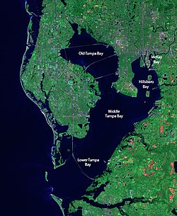
McKay Bay

Last updated
Viewing Tampa, Florida at dusk while overlooking McKay Bay McKay Bay.jpg
Viewing Tampa, Florida at dusk while overlooking McKay Bay

McKay Bay is the name given to the northeastern corner of Tampa Bay, a body of water in Tampa, Florida. The McKay Bay Greenway runs through the area on the east side of McKay Bay and connects to the Tampa Bypass Canal. [1] McKay Bay Nature Park is located at 685 North 34th Street in Tampa. The area also includes the McKay Bay Resource Recovery Plant, a power plant fueled with refuse. [2] The lake was man-made and was once used as a cooling pond for a city incinerator. McKay Bay is at the northeast corner of Hillsborough Bay, which is the name given to the portion of Tampa Bay on the east side of Tampa's Interbay Peninsula. It is named after James McKay Sr.

The Lake is undredged and shallow. It is surrounded by mangrove and salt marsh wetlands. At low tide, the exposed area is a feeding ground for migratory waterfowl, shorebirds and wading birds. Avian residents include the American avocet, black-necked stilt, black skimmer, white pelican, Northern shoveler, canvasback, green wing teal, ruddy duck and glossy ibis. [3]

McKay Bay Nature Park is a 38-acre park on McKay Bay that is part of the larger 200-acre McKay Bay Park and Greenway. The park is a location along the Great Florida Birding Trail. There is a .17 mile boardwalk trail through mangroves and mudflats, an observation tower that doubles as an education pavilion, a paved 1.25 mile multi-use trail and .5-mile nature trail. Picnic tables and interpretive signage are offered.

Related Research Articles

<span class="mw-page-title-main">Hillsborough County, Florida</span> County in Florida, United States

Hillsborough County is located in the west-central portion of the U.S. state of Florida. In the 2020 census, the population was 1,459,762, making it the fourth-most populous county in Florida and the most populous county outside the Miami metropolitan area. A 2021 estimate has the population of Hillsborough County at 1,512,070 people with a yearly growth rate of 1.34%, which itself is greater than the populations of 12 states according to their 2019 population estimates. Its county seat and largest city is Tampa. Hillsborough County is part of the Tampa–St. Petersburg–Clearwater Metropolitan Statistical Area.

<span class="mw-page-title-main">Pinellas County, Florida</span> County in Florida, United States

Pinellas County is a county located on the west central coast of the U.S. state of Florida. As of the 2020 census, the population was 959,107, which makes it the seventh-most populous county in the state. It is also the most densely populated county in Florida, with 3,491 residents per square mile. The county is part of the Tampa–St. Petersburg–Clearwater Metropolitan Statistical Area. Clearwater is the county seat. St. Petersburg is the largest city in the county, as well as the largest city in Florida that is not a county seat.

<span class="mw-page-title-main">Largo, Florida</span> City in Florida, United States

Largo is the third largest city in Pinellas County, Florida, United States, as well as the fourth largest in the Tampa Bay area. As of the 2020 Census, the city had a population of 82,485, up from 77,648 in 2010.

<span class="mw-page-title-main">Everglades National Park</span> National park in Florida (US)

Everglades National Park is an American national park that protects the southern twenty percent of the original Everglades in Florida. The park is the largest tropical wilderness in the United States and the largest wilderness of any kind east of the Mississippi River. An average of one million people visit the park each year. Everglades is the third-largest national park in the contiguous United States after Death Valley and Yellowstone. UNESCO declared the Everglades & Dry Tortugas Biosphere Reserve in 1976 and listed the park as a World Heritage Site in 1979, and the Ramsar Convention included the park on its list of Wetlands of International Importance in 1987. Everglades is one of only three locations in the world to appear on all three lists.

<span class="mw-page-title-main">Tampa Bay</span> Estuary and natural harbor in Florida, off the Gulf of Mexico

Tampa Bay is a large natural harbor and shallow estuary connected to the Gulf of Mexico on the west-central coast of Florida, comprising Hillsborough Bay, McKay Bay, Old Tampa Bay, Middle Tampa Bay, and Lower Tampa Bay. The largest freshwater inflow into the bay is the Hillsborough River, which flows into Hillsborough Bay in downtown Tampa. Many other smaller rivers and streams also flow into Tampa Bay, resulting in a large watershed area.

<span class="mw-page-title-main">Hillsborough River (Florida)</span> River in the United States of America

The Hillsborough River is a river located in the state of Florida in the United States. It arises in the Green Swamp near the juncture of Hillsborough, Pasco and Polk counties, and flows 60 miles (97 km) through Pasco and Hillsborough Counties to an outlet in the city of Tampa on Hillsborough Bay. It includes 4 nature trails extending for over 7 miles (11 km), making it popular among hikers. The name Hillsborough River first appeared on a British map in 1769. At the time, the Earl of Hillsborough was the British Secretary of State for the Colonies, and thus controlled the pensions of the surveyors working in the American colonies, which included East Florida.

<span class="mw-page-title-main">Nature Coast</span> Region in Florida

The Nature Coast is an informal, unofficial region of the U.S. state of Florida. The broadest definition of the Nature Coast includes the eight counties that abut the Gulf of Mexico along the Big Bend Coast defined by geologists: from west to east, Wakulla, Jefferson, Taylor, Dixie, Levy, Citrus, Hernando, and Pasco counties. The name "Nature Coast" was originally devised as part of a marketing campaign to promote tourism in Levy, Citrus, Hernando, and parts of Marion and Pasco counties.

<span class="mw-page-title-main">De Soto National Memorial</span> United States historic place

De Soto National Memorial is a national memorial located in Manatee County, approximately five miles west of Bradenton, Florida. The national memorial commemorates the 1539 landing of Hernando de Soto and the first extensive organized exploration by Europeans of what is now the southern United States. The memorial site comprises 26.84 acres (10.86 ha), where the Manatee River joins Tampa Bay. It has 3,000 feet (910 m) of coastline; eighty percent of the area is mangrove swamp.

<span class="mw-page-title-main">Honeymoon Island State Park</span> State park in Florida, United States

Honeymoon Island State Park is a Florida State Park located on Honeymoon Island, a barrier island across St. Joseph Sound from Dunedin, Palm Harbor, Ozona, and Crystal Beach. The park is 385 acres (1.6 km2) in land area with 2,400 acres (10 km2) submerged and 4 miles (6 km) of beach. It lies at the western end of Causeway Boulevard, which becomes Curlew Road east of Alternate US 19. Its address is 1 Causeway Blvd. Consistently receiving more than one million visitors each year, it is the most-visited state park in Florida.

<span class="mw-page-title-main">Egmont Key State Park and National Wildlife Refuge</span> United States National Wildlife Refuge and state park in Florida

Egmont Key National Wildlife Refuge and State Park is a National Wildlife Refuge and State Park located on the island of Egmont Key, at the mouth of Tampa Bay. Egmont Key lies southwest of Fort De Soto Park and can only be reached by boat or ferry. Located within Egmont Key National Wildlife Refuge and State Park are the 1858 Egmont Key Lighthouse, maintained by the U.S. Coast Guard, and the ruins of Fort Dade, a Spanish–American War era fort that housed 300 residents. Egmont Key is located in Hillsborough County Florida on a narrow strip of the county that extends along the Tampa Port Shipping Channel.

<span class="mw-page-title-main">Withlacoochee River (Florida)</span> River in Florida, United States

The Withlacoochee River or Crooked River is a river in central Florida, in the United States. It originates in the Green Swamp, east of Polk City, flowing west, then north, then northwest and finally west again before emptying into the Gulf of Mexico near Yankeetown. The river is 141 miles (227 km) long and has a drainage basin of 1,170 square miles (3,000 km2).

<span class="mw-page-title-main">Weedon Island Preserve</span> Nature reserve in Florida, US

The Weedon Island Preserve is a 3,190-acre natural area situated along the western shore of Tampa Bay and located at 1800 Weedon Drive NE, St. Petersburg, Florida, United States. It is predominately an estuarine preserve composed of upland and aquatic ecosystems such as mangrove forests, pine/scrubby flatwoods, and maritime hammocks, and is home to a variety of native wildlife. The preserve is also a designated archaeological area, with several shell mounds identified on the property that provide evidence of early peoples who inhabited the land for thousands of years.

<span class="mw-page-title-main">Starkey Wilderness Preserve</span> Nature preserve in Pasco County, Florida, US

Starkey Wilderness Preserve is a public recreation and nature conservation area located in Pasco County, Florida. The park includes a system of hiking, bicycling, and equestrian trails, cabins and primitive camping sites, and picnic areas. It is named after Jay B. Starkey, a cattle rancher who bought the property in 1937 and later donated hundreds of acres. The Preserve consists of three tracts: the Jay B. Starkey Wilderness Park, managed by Pasco County, and Serenova Tract and the Anclote River Ranch Tract, managed by Southwest Florida Water Management District. The area includes sections of pine flatwoods, cypress domes, freshwater marshes, stream and lake swamps, sandhill and scrub over a combined 8,500-acre (34 km2) "wetland ecosystem spread throughout approximately 18,000 acres of conservation lands". The park is located in Western Pasco County east of New Port Richey. The park includes the Starkey Trail, an approximately 6.7 mile paved multi-use trail that links up with the Suncoast Trail at its eastern terminus. There are also unimproved trails in the park. An 8-mile mountain bike trail was approved and being developed as of 2013.

<span class="mw-page-title-main">Bayshore Boulevard</span>

Bayshore Boulevard is a waterfront road on Hillsborough Bay in South Tampa, Florida. Located south of downtown Tampa, its sidewalk, at 4.5 miles (7.2 km) long, is 10 feet (3.0 m) wide and is the longest continuous sidewalk in the United States. The 3-mile (4.8 km) bike lane, a linear park, and the Bayshore Greenway Trail provide scenic views of urban Tampa and the water. The sidewalk's conveniences include benches, a water fountain, bicycle parking, a city marina, and workout stations.

The Balm-Boyette Scrub Nature Preserve is a 5,723-acre (2,316 ha) preserve located in Hillsborough County, Florida. It was purchased through joint funding from the County's Environmental Lands Acquisition and Protection Program (ELAPP) and the State of Florida's Conservation and Recreation Lands (CARL) Program. While it consists largely of abandoned phosphate pits, it has a large area of undisturbed scrub habitat. Natural habitats within the site include sand pine scrub, xeric oak scrub, pine flatwoods, hardwood hammock, wet prairie, freshwater marsh, cypress swamp, and hardwood swamp. During the 1960s the land was pitted with phosphate mines. The natural waterflow had been altered from its original state into a series of stagnant pools. In 2016, a project was undertaken under the umbrella of Swiftmud's Surface Water Improvement and Management, or SWIM, program. The project will create a "habitat mosaic" with habitat for wading birds as well as upland creatures.

Green ARTery is a greenway and trailway plan to connect neighborhoods in Tampa, Florida. The trails are bounded by the Hillsborough River to the North and West, McKay Bay and Old Tampa Bay to the South, and 40th Street to the East. Neighborhoods included in the ARTery include Old Seminole Heights, Southeast Seminole Heights, South Seminole Heights, Woodland Terrace, River Grove, Live Oaks Square, Lake Minihaha & Rogers Golf Course, Hampton Terrace, VM Ybor, East Tampa, Historic Ybor, Ybor Heights, East Ybor, Palmetto Beach, Downtown Tampa, Central Park, Tampa Heights, Ridgewood Park, Riverside Heights, and Channelside (Tampa).

<span class="mw-page-title-main">McKay Bay Nature Park</span> Park in Tampa, Florida, U.S.

McKay Bay Nature Park is a 38-acre (15 ha) park in Tampa.

Lemon Bay is a long, narrow and shallow body of water covering 8,000 acres in Charlotte County, Florida and Sarasota County, Florida. It is protected as the Lemon Bay Aquatic Preserve, designated in 1986. It is one of five Charlotte Harbor Aquatic Preserves. The bay is fed by one Gulf pass, Stump Pass, and seven tributaries and includes areas of mangrove, marsh grass, and seagrass. It provides habitat for bird, invertebrate and fish species and offers fishing, kayaking, birding, wading and beachcombing opportunities.

References

  1. "McKay Bay Greenway". Archived from the original on 2012-09-26. Retrieved 2012-09-13.
  2. McKay Bay Refuse to Energy Facility Archived 2012-09-11 at the Wayback Machine
  3. "McKay Bay Greenway". Archived from the original on 2012-09-26. Retrieved 2012-09-13.

27°56′16″N82°25′25″W / 27.9378°N 82.4236°W / 27.9378; -82.4236