McMillan Sand Filtration Site

Last updated
The District of Columbia government is considering redevelopment plans for the McMillan Sand Filtration Site which is no longer used for water treatment. McMillan Sand Filtration.JPG
The District of Columbia government is considering redevelopment plans for the McMillan Sand Filtration Site which is no longer used for water treatment.

McMillan Sand Filtration Site is a twenty-five acre decommissioned water treatment plant in northwest Washington, D.C., built as part of the historic McMillan Reservoir Park. It is bound on the north by Michigan Avenue, on the east by North Capitol Street, on the south by Channing Street and on the west by McMillan Drive; which runs along the edge of the reservoir, to which it was formerly attached. Two paved courts lined by regulator houses, tower-like sand bins, sand washers and the gated entrances to the underground filter cells provided a promenade for citizens taking the air in the park before it was fenced off in WWII.

Contents

Below grade, there are twenty catacomb-like cells, each an acre in extent, where sand was used to filter water from the Potomac River by way of the Washington Aqueduct. The purification system was a slow sand filter design that became obsolete by the late 20th century. In 1985, a new rapid sand filter plant replaced it across First Street beside the reservoir. The treatment system is operated by the Army Corps of Engineers.

Public access to the site has been restricted since World War II, when the Army erected a fence to guard against sabotage of the city's water supply. Until recently, specially arranged biannual tours were arranged for scores of visitors curious about the odd-looking structures. The site was never reopened to the public on the same basis as before the war.

In 1991, the D.C. Historic Preservation Review Board designated McMillan Park a Historic Landmark and nominated the site for the National Register of Historic Places. It included the site on their "List of Most Endangered Properties in 2000" [1] and again in 2005. [2]

History

Tower-like sand bins covered in greenery as designed by Frederick Law Olmsted Jr. McMillan Park Sand Bins.jpg
Tower-like sand bins covered in greenery as designed by Frederick Law Olmsted Jr.

The 1905 completion of the McMillan Reservoir Sand Filtration Plant was a Washington public health milestone. Its innovative system of water purification, which relied on sand rather than chemicals, led to the elimination of typhoid epidemics and the reduction of many other communicable diseases in the city. [3] A legacy of the City Beautiful Movement and an integral part of the McMillan Plan to modernize Washington, the complex is an engineering wonder that served its original purpose until 1986.

Residents from the ethnically diverse neighborhoods near the park expressed their "delight in this rigidly segregated city in being able to enjoy its amenities regardless of race. Courting couples promenaded on the geometrically laid out avenues on the east site under a canopy of clipped trees. Families, on hot summer nights, slept in the site to catch the summer breezes that blew over the escarpment. During World War I the Girl Scouts camped and grew vegetables on the site between North Capitol Street and First Street. [4] Boys played ball games on the east portion where there were fewer manhole covers near Michigan Avenue. They laughed about sometimes falling through the center of a vault to the white sand beneath when a manhole cover had been left open." [5]

During the Corps of Engineers’ ownership, no commercial development of the site occurred. When the National Capital Planning Commission prepared the federal element of its first Comprehensive Plan in 1983, it included McMillan Park as among the "Parks, Open Space and Natural Features" of the city that "should be conserved and whose essential Open Space Character [be] maintained."[ citation needed ]

The site's future became uncertain, though, in 1986 when the Corps of Engineers declared the property surplus and asked the General Services Administration to dispose of it. GSA iterated its position that open space was not the highest and best use of the property, and insisted on selling the property for mixed commercial development over the objections of the McMillan Park Committee. [6]

The District of Columbia government purchased the site from the federal government in 1987 for $9.3M, in order to facilitate development. Since the time of purchase, the property has remained unused and closed to the public.

Recent events

Development proposals

An October 2021 aerial photo of McMillan Sand Filtration Site McMillanSandFiltration6779-102021.jpg
An October 2021 aerial photo of McMillan Sand Filtration Site

The D.C. government began considering the McMillan Sand Filtration Site for commercial and residential development again in 2007. The National Capital Revitalization Corporation (NCRC), a development agency created by the city, selected the site as part of a land swap deal involving Anacostia riverfront property and the construction of the Nationals Park baseball stadium. (The government dissolved the NCRC in 2007 and merged its functions into the Office of the Deputy Mayor for Planning and Economic Development. [7] )

The government selected a development team, Vision McMillan Partners (VMP), in 2007. [8] Their proposal includes a mix of uses, including housing, shopping and office space. The site would also include a network of accessible park space, including 6.25 acres (2.53 ha) on the southern end of the site, a 1-acre healing garden on the north end, and an acre of green space over a preserved cell at the north end.

The VMP proposal has met with opposition from some neighborhood groups. The team has been meeting with the surrounding neighborhoods since before its selection in 2007 and has included neighborhood input in project revisions. The plan was unanimously approved by the Historic Preservation Review Board in May 2016, which will vote on the buildings on the site but not the overall Master Plan for redevelopment.[ citation needed ]

In 2013 DC Water proposed a plan to use McMillan to provide neighborhood relief of flooding that plagued the Bloomingdale neighborhood, in which the site is situated. The plan calls for the use of two cells to retain water, and to demolish a number of cells in order to provide access to the tunnel they will build on First Street, NW to manage the system.[ citation needed ]

In 2016, courts sided with community activists and rejected the DC Zoning Commission's approval of a $720 million project to transform the site into retail, office and residential space. [9]

City council and court allow development to proceed

A January 2022 aerial photo of McMillan Sand Filtration Site, showing demolition activity McMillanSandFiltration2293-012122.jpg
A January 2022 aerial photo of McMillan Sand Filtration Site, showing demolition activity
McMillan Sand Restoration Site McMillanSand5160-032122.jpg
McMillan Sand Restoration Site
McMillan Sand Restoration Site McMillanSandRestoration5155-032122.jpg
McMillan Sand Restoration Site

In summer 2021 the City Council passed legislation authorizing demolition at the McMillan site. In October 2021 the D.C. Court of Appeals ruled that the proposed development project may proceed pursuant to the legislation. [10] Demolition of the site commenced in October 2021. [11]

See also

Related Research Articles

<span class="mw-page-title-main">Maple Leaf, Seattle</span> Seattle Neighborhood in King, Washington, United States

Maple Leaf is a mostly residential neighborhood located in northeast Seattle.

<span class="mw-page-title-main">Bloomingdale (Washington, D.C.)</span> Place in the United States

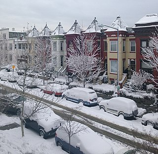
Bloomingdale is a neighborhood in the Northwest quadrant of Washington, D.C., less than two miles (3 km) north of the United States Capitol building. It is a primarily residential neighborhood, with a small commercial center near the intersection of Rhode Island Avenue and First Street NW featuring bars, restaurants, and food markets.

<span class="mw-page-title-main">Washington Aqueduct</span> United States historic place

The Washington Aqueduct is an aqueduct that provides the public water supply system serving Washington, D.C., and parts of its suburbs, using water from the Potomac River. One of the first major aqueduct projects in the United States, it was commissioned by the U.S. Congress in 1852, and construction began in 1853 under the supervision of Montgomery C. Meigs and the U.S. Army Corps of Engineers. Portions of the aqueduct went online on January 3, 1859, and the full pipeline began operating in 1864.

Dalecarlia Reservoir is the primary storage basin for drinking water in Washington, D.C., and Arlington County, Virginia. The reservoir is fed by an underground aqueduct in turn fed by low dams which divert portions of the Potomac River near Great Falls and Little Falls. The reservoir is located between Spring Valley and the Palisades, two neighborhoods in Northwest Washington, D.C., and Brookmont, a neighborhood in Montgomery County, Maryland.

<span class="mw-page-title-main">East Potomac Park</span> Park in the Potomac River, Washington, D.C., U.S.

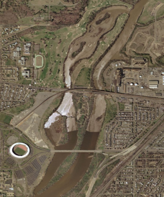
East Potomac Park is a park located on a man-made island in the Potomac River in Washington, D.C., United States. The island is between the Washington Channel and the Potomac River, and on it the park lies southeast of the Jefferson Memorial and the 14th Street Bridge. Amenities in East Potomac Park include the East Potomac Park Golf Course, a miniature golf course, a public swimming pool, tennis courts, and several athletic fields. The park is a popular spot for fishing, and cyclists, walkers, inline skaters, and runners heavily use the park's roads and paths. A portion of Ohio Drive SW runs along the perimeter of the park.

<span class="mw-page-title-main">Washington Suburban Sanitary Commission</span> Political subdivision of Maryland

The Washington Suburban Sanitary Commission is a bi-county political subdivision of the State of Maryland that provides safe drinking water and wastewater treatment for Montgomery and Prince George's Counties in Maryland except for a few cities in both counties that continue to operate their own water facilities.

<span class="mw-page-title-main">Tidal Basin</span> Reservoir in Washington, D.C.

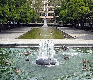
The Tidal Basin is a man-made reservoir located between the Potomac River and the Washington Channel in Washington, D.C. The Basin is part of West Potomac Park, is near the National Mall and is a focal point of the National Cherry Blossom Festival held each spring. The nearby Jefferson Memorial, Martin Luther King Jr. Memorial and Franklin Delano Roosevelt Memorial overlook the Basin, which is south of the Washington Monument.

<span class="mw-page-title-main">McMillan Reservoir</span> Reservoir in Washington, D.C.

The McMillan Reservoir is a reservoir in Washington, D.C., that supplies the majority of the city's municipal water. It was originally called the Howard University Reservoir or the Washington City Reservoir, and was completed in 1902 by the U.S. Army Corps of Engineers.

<span class="mw-page-title-main">Georgetown Reservoir</span> Reservoir in District of Columbia

The Georgetown Reservoir is a reservoir that provides water to the District of Columbia. Part of the city’s water supply and treatment infrastructure, it is located in the Palisades neighborhood, approximately two miles downstream from the Maryland–D.C. boundary.

<span class="mw-page-title-main">Kingman Island</span>

Kingman Island and Heritage Island are islands in Northeast and Southeast Washington, D.C., in the Anacostia River. Both islands are man-made, built from material dredged from the Anacostia River and completed in 1916. Kingman Island is bordered on the east by the Anacostia River, and on the west by 110-acre (45 ha) Kingman Lake. Heritage Island is surrounded by Kingman Lake. Both islands were federally owned property managed by the National Park Service until 1995. They are currently owned by the D.C. government, and managed by Living Classrooms National Capital Region. Kingman Island is bisected by Benning Road and the Ethel Kennedy Bridge, with the southern half of the island bisected again by East Capitol Street and the Whitney Young Memorial Bridge. As of 2010, Langston Golf Course occupied the northern half of Kingman Island, while the southern half of Kingman Island and all of Heritage Island remained largely undeveloped. Kingman Island, Kingman Lake and nearby Kingman Park are named after Brigadier General Dan Christie Kingman, the former head of the United States Army Corps of Engineers.

<span class="mw-page-title-main">McMillan Plan</span> 1902 planning report for Washington, D.C.

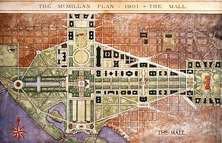
The McMillan Plan is a comprehensive planning document for the development of the monumental core and the park system of Washington, D.C., the capital of the United States. It was written in 1902 by the Senate Park Commission. The commission is popularly known as the McMillan Commission after its chairman, Senator James McMillan of Michigan.

<span class="mw-page-title-main">Fort Reno Park</span> Park in Washington, D.C., U.S.

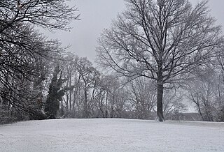
Fort Reno Park is an urban park in the Tenleytown neighborhood of Northwest Washington, D.C. It is named after Fort Reno, one of the only locations in the District of Columbia to see combat during the American Civil War. The park was established in the 1920s to clear an African American neighborhood called Reno from the site, in what was becoming an affluent white suburban area.

<span class="mw-page-title-main">Greenway (Washington, D.C.)</span> Neighborhood in Ward 7, United States

Greenway is a residential neighborhood in Southeast Washington, D.C., in the United States. The neighborhood is bounded by East Capitol Street to the north, Pennsylvania Avenue SE to the south, Interstate 295 to the west, and Minnesota Avenue to the east.

<span class="mw-page-title-main">Castle Gatehouse, Washington Aqueduct</span> United States historic place

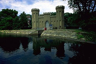
Castle Gatehouse, Washington Aqueduct is a pumping station at the Georgetown Reservoir on the Washington Aqueduct in The Palisades neighborhood of Washington, D.C., United States. The building is on the National Register of Historic Places and contributes to the Washington Aqueduct National Historic Landmark.

<span class="mw-page-title-main">Anacostia Waterfront Corporation</span> Defunct government-owned corporation in the United States

The Anacostia Waterfront Corporation (AWC) was a government-owned corporation established in 2004 by the government of District of Columbia, in the United States, to revitalize neighborhoods next to the Anacostia River and to coordinate the environmental rehabilitation and use of the river. The corporation was intended to have a 20-year lifespan, during which it would oversee an $8 billion public-private redevelopment plan covering the Anacostia River waterfront and numerous parcels of land in the city east of the river. However, a change in mayoral administrations and frustration with the slow pace of redevelopment resulted in the abolition of the corporation after three years.

<span class="mw-page-title-main">The Yards (Washington, D.C.)</span> Urban park development in Washington, D.C.

The Yards is a 42-acre (17 ha) development on the Anacostia River waterfront in Washington, D.C. The area is at the center of the Capitol Riverfront Business Improvement District and was originally an annex of the Washington Navy Yard. The development is part of the larger Navy Yard neighborhood. In 2004, the U.S. General Services Administration awarded the property to Forest City Washington, Inc. for redevelopment into an area with 2,800 new residential units and 2,200,000 sq ft (200,000 m2) of office and retail space. The development is situated in the Navy Yard neighborhood, located just west of the historic Washington Navy Yard and east of Nationals Park. It is served by the Navy Yard – Ballpark station on the Green Line of the Washington Metro.

<span class="mw-page-title-main">McMillan Fountain</span>

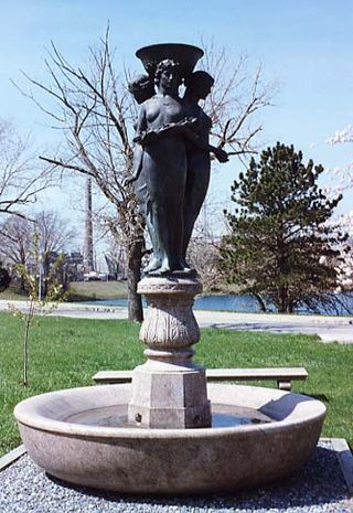
The McMillan Fountain is a public artwork by American artist Herbert Adams located on the McMillan Reservoir grounds. The fountain, completed in 1912 and dedicated in October 1919, consists of a sculptural group of the Three Graces placed upon a pink granite base. Cast by Roman Bronze Works, the fountain was originally part of a large landscape setting designed by Charles A. Platt. The fountain currently resides near its original location at McMillan Reservoir in the Bloomingdale neighborhood of Washington, D.C.

<span class="mw-page-title-main">Rawlins Park</span> Park in Washington, D.C., U.S.

Rawlins Park is a rectangular public park in the Foggy Bottom neighborhood of Washington, D.C., two blocks west of the White House grounds and two blocks north of the National Mall. The boundaries of the park are 18th Street NW to the east, E Street NW to the south and north, and 19th Street NW to the west. The park was an undeveloped open space for many years, until plans were made to install the statue of John Aaron Rawlins in 1874. Various improvements were made, but the area surrounding the park remained mostly undeveloped. This changed in the 1890s when the area was cleared of marshes, and houses were built on the park's southern border.

Seneca Dam was the last in a series of dams proposed on the Potomac River in the area of the Great Falls of the Potomac. Apart from small-scale dams intended to divert water for municipal use in the District of Columbia and into the Chesapeake and Ohio Canal, no version of any scheme was ever built. In most cases the proposed reservoir would have extended upriver to Harpers Ferry, West Virginia. The project was part of a program of as many as sixteen major dams in the Potomac watershed, most of which were never built.

References

  1. DC Preservation League. "List of Most Endangered Properties in 2000." Archived February 28, 2009, at the Wayback Machine
  2. DC Preservation League. "List of Most Endangered Properties in 2005." Archived 2010-10-12 at the Wayback Machine
  3. Scott, Pamela (2007), "Capital Engineers: The U.S. Army Corps of Engineers in the Development of Washington, D.C., 1790-2004." Archived 2012-02-26 at the Wayback Machine pp. 173-177. Washington, DC: U.S. Army Corps of Engineers. Publication No. EP 870-1-67.
  4. Among The Girl Scouts, The Washington Post, July 20, 1917
  5. Testimony of Anne Sellin re B16-0902, the Transfer of McMillan Park Reservoir to NCRC, October 20, 2006.
  6. McMillan Park Committee v. National Capital Planning Commission, 968 F2d 1283 (D.C. Cir. 1992).
  7. District of Columbia Government (2007). "District Consolidates Economic Development Agencies." Press release. 2007-07-20.
  8. "Mayor Fenty Announces Development Partner for Former McMillan Sand Filtration Site" (Press release). District of Columbia Government. June 13, 2007.
  9. Stein, Perry (December 8, 2016). "The fight to develop McMillan Park continues: Court rules against zoning commission". The Washington Post.
  10. Schwartzman, Paul (2021-10-28). "D.C.'s highest court clears way for McMillan development to proceed". The Washington Post.
  11. "Demolition has finally started at McMillan. But the project's opponents aren't giving up yet" . Washington Business Journal. 2021-10-12.

38°55′28.1″N77°0′37.7″W / 38.924472°N 77.010472°W / 38.924472; -77.010472