
Indian Territory and the Indian Territories are terms that generally described an evolving land area set aside by the United States government for the relocation of Native Americans who held original Indian title to their land as a sovereign independent state. The concept of an Indian territory was an outcome of the U.S. federal government's 18th- and 19th-century policy of Indian removal. After the American Civil War (1861–1865), the policy of the U.S. government was one of assimilation.

Medicine Lodge is a city in and the county seat of Barber County, Kansas, United States. As of the 2020 census, the population of the city was 1,781.

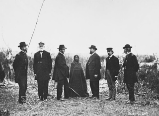
Black Kettle was a prominent leader of the Southern Cheyenne during the American Indian Wars. Born to the Northern Só'taeo'o / Só'taétaneo'o band of the Northern Cheyenne in the Black Hills of present-day South Dakota, he later married into the Wotápio / Wutapai band of the Southern Cheyenne.
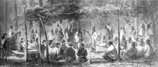
The Medicine Lodge Treaty is the overall name for three treaties signed near Medicine Lodge, Kansas, between the Federal government of the United States and southern Plains Indian tribes in October 1867, intended to bring peace to the area by relocating the Native Americans to reservations in Indian Territory and away from European-American settlement. The treaty was negotiated after investigation by the Indian Peace Commission, which in its final report in 1868 concluded that the wars had been preventable. They determined that the United States government and its representatives, including the United States Congress, had contributed to the warfare on the Great Plains by failing to fulfill their legal obligations and to treat the Native Americans with honesty.
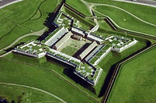
Fort Stanwix was a colonial fort whose construction commenced on August 26, 1758, under the direction of British General John Stanwix, at the location of present-day Rome, New York, but was not completed until about 1762. The bastion fort was built to guard a portage known as the Oneida Carry during the French and Indian War. Fort Stanwix National Monument, a reconstructed structure built by the National Park Service, now occupies the site.

The Wyandotte Nation is a federally recognized Native American tribe headquartered in northeastern Oklahoma. They are descendants of the Wendat Confederacy and Native Americans with territory near Georgian Bay and Lake Huron. Under pressure from Haudenosaunee and other tribes, then from European settlers and the United States government, the tribe gradually moved south and west to Michigan, Ohio, Kansas, and finally Oklahoma in the United States.

Ocmulgee Mounds National Historical Park in Macon, Georgia, United States preserves traces of over ten millennia of culture from the Native Americans in the Southeastern Woodlands. Its chief remains are major earthworks built before 1000 CE by the South Appalachian Mississippian culture These include the Great Temple and other ceremonial mounds, a burial mound, and defensive trenches. They represented highly skilled engineering techniques and soil knowledge, and the organization of many laborers. The site has evidence of "12,000 years of continuous human habitation." The 3,336-acre (13.50 km2) park is located on the east bank of the Ocmulgee River. Macon, Georgia developed around the site after the United States built Fort Benjamin Hawkins nearby in 1806 to support trading with Native Americans.

Norridgewock was the name of both an Indigenous village and a band of the Abenaki Native Americans/First Nations, an Eastern Algonquian tribe of the United States and Canada. The French of New France called the village Kennebec. The tribe occupied an area in the interior of Maine. During colonial times, this area was territory disputed between British and French colonists, and was set along the claimed western border of Acadia, the western bank of the Kennebec River.

New Echota was the capital of the Cherokee Nation in the Southeast United States from 1825 until their forced removal in the late 1830s. New Echota is located in present-day Gordon County, in northwest Georgia, 3.68 miles north of Calhoun. It is south of Resaca, next to present day New Town, known to the Cherokee as Ꭴꮝꮤꮎꮅ, Ustanali. The site has been preserved as a state park and a historic site. It was designated in 1973 as a National Historic Landmark District.

Fort Gibson is a historic military site next to the modern city of Fort Gibson, in Muskogee County Oklahoma. It guarded the American frontier in Indian Territory from 1824 to 1888. When it was constructed, the fort was farther west than any other military post in the United States. It formed part of the north–south chain of forts that was intended to maintain peace on the frontier of the American West and to protect the southwestern border of the Louisiana Purchase. The fort succeeded in its peacekeeping mission for more than 50 years, as no massacres or battles occurred there.
The Battle of Taliwa was fought in Ball Ground, Georgia in 1755. The battle was part of a larger campaign of the Cherokee against the Muscogee Creek people, where an army of 500 Cherokee warriors led by Oconostota defeated the Muscogee Creek people and pushed them south from their northern Georgia homelands, allowing the Cherokee to begin settling in the region.

The Huron Indian Cemetery in Kansas City, Kansas, also known as Huron Park Cemetery, is now formally known as the Wyandot National Burying Ground. It was established circa 1843, soon after the Wyandot had arrived following removal from Ohio. The tribe settled in the area for years, with many in 1855 accepting allotment of lands in Kansas in severalty. The majority of the Wyandot removed to Oklahoma in 1867, where they maintained tribal institutions and communal property. As a federally recognized tribe, they had legal control over the communal property of Huron Cemetery. For more than 100 years, the property has been a source of controversy between the federally recognized Wyandotte Nation, based in Oklahoma, which wanted to sell it for redevelopment, and the much smaller, unrecognized Wyandot Nation of Kansas, which wanted to preserve the burying ground.

Town Creek Indian Mound is a prehistoric Native American archaeological site located near present-day Mount Gilead, Montgomery County, North Carolina, in the United States. The site, whose main features are a platform mound with a surrounding village and wooden defensive palisade, was built by the Pee Dee, a South Appalachian Mississippian culture people that developed in the region as early as 980 CE. They thrived in the Pee Dee River region of North and South Carolina during the Pre-Columbian era. The Town Creek site was an important ceremonial site occupied from about 1150—1400 CE. It was abandoned for unknown reasons. It is the only ceremonial mound and village center of the Pee Dee located within North Carolina.

The Dancing Rabbit Creek Treaty Site is a historic Choctaw Native American gathering place in rural Noxubee County, Mississippi. Located near a freshwater spring above the floodplain of Dancing Rabbit Creek in the southwestern part of the county, it was the site of a treaty negotiation between the Choctaw and the federal government in 1830, resulting in the Treaty of Dancing Rabbit Creek, in which the Choctaw agreed to surrender their ancestral lands for territory in what is now Oklahoma. It was the first treaty negotiated after passage of the Indian Removal Act, and served as a model for other treaties passed pursuant to that act. It also led to the Choctaw Trail of Tears. The site, now marked by a stone memorial and a small Choctaw cemetery, was designated a National Historic Landmark in 1996.

Camp Disappointment is the northernmost campsite of the Lewis and Clark Expedition, on its return trip from the Pacific Northwest. The site is on private land within the Blackfeet Indian Reservation in Glacier County, Montana. It is located along the south bank of Cut Bank Creek and 12 miles (19 km) northeast of Browning, Montana. Glacier National Park can be seen in the distance.

Creek National Capitol, also known as Creek Council House, is a building in downtown Okmulgee, Oklahoma, in the United States. It was capitol of the Muscogee (Creek) Nation from 1878 until 1907. They had established their capital at Okmulgee in 1867, after the American Civil War.

Minisink Archeological Site, also known as Minisink Historic District, is an archeological site of 1320 acres located in both Sussex County, New Jersey and Pike County, Pennsylvania. It was part of a region occupied by Munsee-speaking Lenape that extended from southern New York across northern New Jersey to northeastern Pennsylvania. The Munsee were speakers of one of the three major language dialects of the Lenape Native American tribe. This interstate territory became the most important Munsee community for the majority of the 17th and 18th centuries.
The Indian Peace Commission was a group formed by an act of Congress on July 20, 1867 "to establish peace with certain hostile Indian tribes." It was composed of four civilians and three, later four, military leaders. Throughout 1867 and 1868, they negotiated with a number of tribes, including the Comanche, Kiowa, Arapaho, Kiowa-Apache, Cheyenne, Lakota, Navajo, Snake, Sioux, and Bannock. The treaties that resulted were designed to move the tribes to reservations, to "civilize" and assimilate these native peoples, and transition their societies from a nomadic to an agricultural existence.
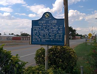
Fort Cobb was a United States Army post established in what is now Caddo County, Oklahoma in 1859 to protect relocated Native Americans from raids by the Comanche, Kiowa, and Cheyenne. The fort was abandoned by Maj. William H. Emory at the beginning of the Civil War, but then occupied by Confederate forces from 1861–1862. The post was eventually reoccupied by US forces starting in 1868. After establishing Fort Sill the US Army abandoned Fort Cobb. Today there is little left of the former military post.

The Cherokee Nation was a legal, autonomous, tribal government in North America recognized from 1794 to 1907. It was often referred to simply as "The Nation" by its inhabitants. The government was effectively disbanded in 1907, after its land rights had been extinguished, prior to the admission of Oklahoma as a state. During the late 20th century, the Cherokee people reorganized, instituting a government with sovereign jurisdiction known as the Cherokee Nation. On July 9, 2020, the United States Supreme Court ruled that the Muscogee (Creek) Nation had never been disestablished in the years before allotment and Oklahoma Statehood.


