Menomonee Valley

Last updated
Menomonee River Menomonee River.jpg
Menomonee River

The Menomonee Valley or Menomonee River Valley is a U-shaped land formation along the southern bend of the Menomonee River in Milwaukee, Wisconsin. Because of its easy access to Lake Michigan and other waterways, the neighborhood has historically been home to the city's stockyards, rendering plants, shipping, and other heavy industry. It was also a primary source of pollution for the river.

Contents

Glacial meltwater formed the Menomonee Valley over 10,000 years ago when the Lake Michigan Lobe of the Wisconsin Glaciation retreated and eroded a swath four miles (6 km) long and half of a mile wide. Today, it is roughly bounded by the 6th Street Viaduct near the river confluence and Miller Park stadium to the west. The valley effectively cuts Milwaukee in half, limiting access to a handful of viaducts that span the chasm.

With a historically predominant white south side and black near north side, the valley has been perceived as a social and racial divide during times of civil unrest. In the 1960s, Father James Groppi organized protests against segregation in Milwaukee and led a number of fair housing marches across this symbolic divide. The 16th Street Viaduct has since been renamed in his honor.

History

Early settlers

Abundant wild rice once grew in the marshland of the confluence and along the shores of the river, which the Menomonee (also spelled Menominee) Indians named for its "good seed." These wetlands provided them with the staples of life and allowed for access further inland. Archaeologist Charles Brown later identified five settlements along the valley rim. Another fourteen archaeological points of interest have since been marked within the valley based on historical accounts, but it is unlikely that anything would be found because of improvements. By the 19th century, displaced Potawatomi were the primary residents.

Missionary Jacques Marquette is the first European known to have explored the area, with other French-Canadian fur traders arriving in the late 17th century. The first permanent trading post was established by Jacques Vieau in 1795, while employed by the North West Company. Vieau built his cabin on top of a bluff overlooking the Menomonee Valley in what is now Mitchell Park. He was later joined by Solomon Juneau in 1818, who started one of three settlements that incorporated into the City of Milwaukee.

Development

Menomonee Valley in 1882 The menomonee valley in milwaukee 1882.jpg
Menomonee Valley in 1882

Reshaping of the valley began with the railroads built by city co-founder Byron Kilbourn to bring product from Wisconsin's farm interior to the port. By 1862 Milwaukee was the largest shipper of wheat on the planet, and related industry developed. Grain elevators were built and, due to Milwaukee's dominant German immigrant population, breweries sprang up around the processing of barley and hops. A number of tanneries were constructed, of which the Pfister & Vogel tannery grew to become the largest in America.

In 1843 George Burnham and his brother Jonathan opened a brickyard near 16th Street. When a durable and distinct cream-colored brick came out of the clay beds, other brickyards sprang up to take advantage of this resource. Because many of the city's buildings were built using this material it earned the nickname "Cream City," and conversely the brick was called Cream City brick. By 1881 the Burnham brickyard, which employed 200 men and peaked at 15 million bricks a year, was the largest in the world.

Menomonee Valley in 2006 Menomonee Valley.jpg
Menomonee Valley in 2006

Industrialization

Flour mills, packing plants, breweries, railways and tanneries further industrialized the valley. With the marshlands drained and the Kinnickinnic and Milwaukee Rivers dredged, attention turned to the valley. In 1869 an initiative was undertaken to channelize the Menomonee River and build a series of ship canals, which included Kneeland's Canal, Holton's Canal, Menomonee Canal, South Menomonee Canal and Burnham Canal. Part of South Menomonee Canal, Menomonee Canal, Kneeland's Canal and Holton's Canal have since been filled in, and Burhham canal is no longer navigable after extension of 11th St. with street level bridge in mid 1980s. [1]

Unimaginable amounts of fill came down from the bluffs to raise the valley floor an average of 22 feet (6.7 m) and lower the north rim by as much as 60 feet (18 m). The steep inclines of the valley walls were softened, and more rail lines were put in. By the turn of the 20th century, the once natural marshlands teeming with wild rice, and water fowl was all but forgotten.

The first viaduct was completed in 1878 along 6th Street. It was later replaced in 1908 and again in 2002 with a photogenic design-build cable-stayed span touting dual bascule bridges. [2] Other crossings followed with the 16th Street Viaduct in 1895 (replaced in 1929), the 27th Street Viaduct in 1910, and the 35th Street Viaduct in 1933.

By 1879 meat packing became the most important industry in the city, and the Menomonee Valley was a critical supply point for the likes of John Plankinton, Frederick Layton and Philip Armour. Packing houses populated the valley floor near the Milwaukee & St. Paul Railroad stockyard. A young Patrick Cudahy worked his way up through the ranks and went on to become owner of what is now Patrick Cudahy, Inc. Cudahy moved his operations to what later became the Milwaukee suburb of Cudahy, Wisconsin in 1892.

Along with the processing industries, bulk commodity storage and machining & manufacturing entered the scene. The valley was home to the Milwaukee Road, Falk Corporation, Cutler-Hammer, Harnischfeger Corporation, Chain Belt Company, Nordberg Manufacturing Company and other industry giants.

Heavy pollution and noxious odors became a problem as early as 1874 when a distillery was charged for producing "a nuisance simply stupendous in character." A Grand Jury was assembled in 1886 to tour the river and discover the origin of all the filth. One lecturer remarked that he "nearly stifled as the steamer came up the harbor this morning." The city also built an ill-conceived garbage crematory in 1890 that, along with the factories, locomotives and foundries, pumped clouds of acrid smoke which covered the valley in a thick layer of soot.

After World War II the economics of the valley declined because of a shift from rail and ship transportation to the interstate highways. Milwaukee also became part of the Rust Belt as recession set in, and the heavily industrialized Menomonee Valley was affected the most. By the late 1970s the Menomonee Valley was perceived by many to be an ugly blight in the heart of the city.

Hank Aaron State Trail HankAaronStateTrail, ValleyPowerPlant.jpg
Hank Aaron State Trail

Rejuvenation

During the administration of Mayor Henry Maier the city purchased land for redevelopment. It paved roads to improve truck access and built a municipal garage along Canal Street, but these token gestures were not enough. It was not until a series of coordinated efforts started by Mayor John Norquist in 1988 that the valley began to see new growth. A "Renew the Valley" initiative was formed to revitalize the Menomonee Valley and increase available green space. Menomonee Valley Partners, Inc., a nonprofit organization, was formed in 1999 through a public-private partnership to oversee and coordinate efforts to revitalize the valley. [3]

Anchors such as Potawatomi Hotel & Casino [4] and a Milwaukee Metropolitan Sewerage District facility spurred development. Marquette University built an athletic field across the river just south of the main campus, and Emmpak Foods helped to beautify the area with a sculpture garden. A segment of the Hank Aaron State Trail was also paved along the Menomonee River to return public access to the waterway. In 2013, the 24-acre Three Bridges Park opened on a former rail yard site along the south bank of the Menomonee River between 27th and 35th streets, incorporating the improved trail as well as new bridge crossings and freshly planted native vegetation. [5] Using leftover fill from the Marquette Interchange reconstruction project, the new park also includes landforms shaped to resemble typical glacial features from the area's geologic past, such as kames, drumlins, and eskers. [6]

The Harley-Davidson Museum Harley-Davidson Museum 0057.jpg
The Harley-Davidson Museum

The abandoned 140-acre (0.57 km2) Milwaukee Road yards have been made into a business park with an innovative storm water runoff buffer using native plants. The $20 million brownfield project has been called the city's "largest environmental clean up in history." [7] Two of the landmark smoke stacks standing in Chimney Park to memorialize what were once the largest rail yards in the nation have since been torn down because they were too unstable.

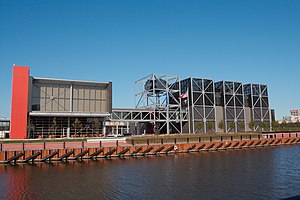
Harley-Davidson built a $75 million 130,000-square-foot (12,000 m2) Harley-Davidson Museum at 6th & Canal Streets, which broke ground on June 1, 2006. It houses the company's vast collection of historic motorcycles and corporate archives, along with a restaurant, café and meeting space. [8]

In 2015, the City of Milwaukee adopted the area plan Menomonee Valley 2.0 led by LA DALLMAN, the Wisconsin and Boston-based architecture practice of Grace La and James Dallman, in collaboration with numerous stakeholders and members of the community. [9] This updated plan includes the newly created nonprofit Menomonee Valley Partners, along with replacing the 6th St viaduct with bridges that extend access into the valley, and redevelopment of the former Milwaukee Road Shops sites into the Menomonee Valley Industrial Center. [10] [11]

See also

Related Research Articles

<span class="mw-page-title-main">Milwaukee</span> City in Wisconsin, United States

Milwaukee is a city in the U.S. state of Wisconsin and the county seat of Milwaukee County. With a population of 577,222 at the 2020 census, Milwaukee is the 31st largest city in the United States, the fifth-largest city in the Midwest, and the largest city in the state of Wisconsin.

<span class="mw-page-title-main">Wauwatosa, Wisconsin</span> City in Wisconsin, United States

Wauwatosa is a city in Milwaukee County, Wisconsin, United States. The population was 48,387 at the 2020 census. Wauwatosa is located immediately west of Milwaukee, and is a part of the Milwaukee metropolitan area. It is named after the Potawatomi Chief Wauwataesie and the Potawatomi word for firefly.

<span class="mw-page-title-main">Mequon, Wisconsin</span> City in Ozaukee County, Wisconsin

Mequon is the largest city in Ozaukee County, in the U.S. state of Wisconsin, and the third-largest city in Wisconsin by land area. Located on Lake Michigan's western shore with significant commercial developments along Interstate 43, the community is a suburb in the Milwaukee metropolitan area. Despite being an incorporated city, approximately half of Mequon's land is undeveloped and agriculture plays a significant role in the local economy. At the time of the 2010 census the population was 23,132.

<span class="mw-page-title-main">Fox River (Green Bay tributary)</span> River in Wisconsin, United States

The Fox River is a river in eastern Wisconsin in the Great Lakes region of the United States. It is the principal tributary of Green Bay, and via the Bay, the largest tributary of Lake Michigan. The well-known city of Green Bay, one of the first European settlements in North America, is on the river at its mouth on lower Green Bay.

<span class="mw-page-title-main">Solomon Juneau</span> American mayor (1793–1856)

Solomon Laurent Juneau, or Laurent-Salomon Juneau was a French Canadian fur trader, land speculator, and politician who helped found the city of Milwaukee, Wisconsin. He was born in Repentigny, Quebec, Canada to François and (Marie-)Thérèse Galarneau Juneau. His cousin was Joseph Juneau, who founded the city of Juneau, Alaska.

The Marquette Interchange is a major freeway interchange in downtown Milwaukee, Wisconsin, located near Marquette University where Interstate 43, I-94, and I-794 meet. Originally built in the 1960s, the interchange underwent a total rebuild between 2004 and 2008, and was officially opened on August 19, 2008, after what was at the time the largest construction project in state history. During the early 2000s, U.S. Highway 41 (US 41) had followed I-94 through the interchange. This had changed when I-41 was designated in the Milwaukee area. US 41 now follows I-41 through the Zoo Interchange instead.

<span class="mw-page-title-main">Patrick Cudahy</span>

Patrick Cudahy Jr. ; March 17, 1849 – July 25, 1919) was an American industrialist in the meat packing business and a patriarch of the Cudahy family.

<span class="mw-page-title-main">Milwaukee River</span> River in Wisconsin

The Milwaukee River is a river in the state of Wisconsin. It is about 104 miles (167 km) long. Once a locus of industry, the river is now the center of a housing boom. New condos now crowd the downtown and harbor districts of Milwaukee attracting young professionals to the area. The river is also ribboned with parks as it winds through various neighborhoods. Kayaks and fishing boats share the river with party boats. An extensive Riverwalk featuring art displays, boat launches and restaurants lines its banks in downtown Milwaukee.

<span class="mw-page-title-main">Interstate 794</span> Highway in Wisconsin

Interstate 794 is a 3.75-mile (6.04 km) auxiliary Interstate Highway in Milwaukee County in the US state of Wisconsin. It is one of two auxiliary Interstates in the Milwaukee metropolitan area, serves the lakefront and the Port of Milwaukee, and connects downtown with the southeastern suburbs of St. Francis, Cudahy, and South Milwaukee.

<span class="mw-page-title-main">Jacques Vieau</span>

Jacques Vieau was a French-Canadian fur trader and the first permanent white settler in Milwaukee, Wisconsin. He was born near Montreal, Quebec, Canada and died in Howard, Wisconsin.

<span class="mw-page-title-main">Potawatomi Hotel & Casino</span> Hotel in Milwaukee, United States

Potawatomi Hotel & Casino, formerly Potawatomi Bingo Casino, is a Native American casino in Milwaukee, Wisconsin, United States, owned and operated by the Forest County Potawatomi Community. It first opened its doors March 7, 1991. Located on Canal Street in the Menomonee Valley near Downtown Milwaukee, this entertainment destination offers a variety of entertainment options, including a 20-table poker room, multiple restaurants and dining options, a food court, a sports book, and the Sky Lodge. It's a popular destination spot for visitors outside of Milwaukee.

<span class="mw-page-title-main">Neighborhoods of Milwaukee</span>

The neighborhoods of Milwaukee include a number of areas in southeastern Wisconsin within the state's largest city at nearly 600,000 residents.

Milwaukee, Wisconsin's history, which includes over 160 years of immigration, politics, and industry, has given it a distinctive heritage.

<i>Oops, Missed</i>

Oops, Missed is a public artwork by American Bernard Peck located at 1515 West Canal Street, just off the 16th street viaduct, in Milwaukee, Wisconsin, United States. It was dedicated in July 1987. It is made of brick and stainless steel.

<span class="mw-page-title-main">Valley Fields</span>

Valley Fields is a 1,750-seat outdoor stadium and practice facility in Milwaukee, Wisconsin, primarily used by the varsity men's and women's soccer and lacrosse teams at Marquette University, all of which compete in the Big East Conference. The complex houses bleachers, locker rooms, practice fields and a main stadium.

<span class="mw-page-title-main">Court Street Commercial Historic District</span> Historic district in Wisconsin, United States

The Court Street Commercial Historic District is a largely intact part of the old downtown of Richland Center, Wisconsin. It was added to the National Register of Historic Places in 1989 - a 11.2 acres (4.5 ha) historic district which included 51 contributing buildings and 20 non-contributing ones. The buildings are commercial, mostly in Late Victorian styles constructed from 1870 to 1938. Most are brick two-story buildings; a few one-story and three-story brick buildings are interspersed.

Pfister & Vogel (P&V) was an American tannery business in Milwaukee, Wisconsin.

<span class="mw-page-title-main">Walker's Point Historic District</span> Historic district in Wisconsin, United States

The Walker's Point Historic District is a mixed working-class neighborhood of homes, stores, churches and factories in Milwaukee, Wisconsin, with surviving buildings as old as 1849, including remnants of the Philip Best Brewery and the Pfister and Vogel Tannery. In 1978 it was added to the National Register of Historic Places. The NRHP nomination points out that Walker's Point was "the only part of Milwaukee's three original Settlements to reach the last quarter of the Twentieth Century with its Nineteenth and early-Twentieth Century fabric still largely intact," and ventures that "For something similar, one would have to travel to Cleveland or St. Louis if, indeed, so cohesive and broad a grouping of...structures still exists even in those cities."

<span class="mw-page-title-main">Freeways of Milwaukee</span>

In Milwaukee, freeways were constructed in response to an 8.5% increase in population during the 1940s. Road plans were drawn up in the 1950s through the 1970s and several freeways were built. A lack of foresight resulted in several communities experiencing sharp increases in property taxes such as in West Milwaukee, or the complete destruction of vibrant, African-American neighborhoods such as Bronzeville. After a decade of aggressive highway building in the 1960s, support for freeway construction began to wane as neighborhoods started to oppose construction. With the election of John Norquist as mayor in 1988, Milwaukee began to undo some of the damage of its highway construction. The dismantling of the Park East Freeway north of downtown led to a housing and entertainment construction boom and is the location of Fiserv Forum.

<span class="mw-page-title-main">Downtown Milwaukee</span> Area of Milwaukee, Wisconsin, United States

Downtown Milwaukee is the central business district of Milwaukee, Wisconsin. The economic and symbolic center of the city and the Milwaukee metropolitan area, it is Milwaukee's oldest district and home to many of region's cultural, financial educational and historical landmarks including Milwaukee City Hall, Fiserv Forum and the Milwaukee Art Museum. The city's modern history began in Downtown Milwaukee in 1795 when fur trader Jacques Vieau (1757–1852) built a post along a bluff on the east side, overlooking the Milwaukee and Menomonee rivers.

References

  1. "EPA proposes Burnham Canal cleanup". Archive.jsonline.com. Retrieved 24 November 2021.
  2. Milwaukee’s Old Sixth Street Viaduct Yields to Modern Cable-Stayed Spans, Construction Equipment Guide, Retrieved December 25, 2010.
  3. "Menomonee River Valley". Thevalleymke.org. Retrieved 24 November 2021.
  4. "Newly named Potawatomi Hotel & Casino to open hotel in August". Bizjournals.com. Retrieved 24 November 2021.
  5. "Three Bridges Park opens in Menomonee Valley". Jsonline.com. Retrieved 24 November 2021.
  6. "Menomonee Valley park builds bridges to rolling urban green space". Onmilwaukee.com. 3 June 2013. Retrieved 24 November 2021.
  7. City completes largest environmental clean up in history, City of Milwaukee, November 28, 2004.
  8. Harley-Davidson kick-starts $75M museum project, The Business Journal, June 1, 2006.
  9. "Valley 2.0 Plan". Menomonee River Valley. Retrieved 25 December 2018.
  10. "Menomonee Valley Plan" (PDF). The City of Milwaukee. Retrieved 25 December 2018.
  11. "Menomonee Valley Riverwalk Designs Underway". The City of Milwaukee. Retrieved 25 December 2018.

Sources

43°01′58″N87°55′59″W / 43.032750°N 87.932990°W / 43.032750; -87.932990