
South Kalimantan is a province of Indonesia. It is the second most populous province on the island of Kalimantan, the Indonesian territory of the island of Borneo after West Kalimantan. The provincial capital was Banjarmasin until 15 February 2022 when it was legally moved 35 kms southeast to Banjarbaru. The population of South Kalimantan was recorded at just over 3.625 million people at the 2010 Census, and at 4.07 million at the 2020 Census. The official estimate as at mid 2023 was 4,221,929. One of the five Indonesian provinces in Kalimantan, it is bordered by the Makassar Strait in the east, Central Kalimantan in the west and north, the Java Sea in the south, and East Kalimantan in the northeast. The province also includes the island of Pulau Laut, located off the eastern coast of Kalimantan, as well as other smaller offshore islands. The province is divided into 11 regencies and 2 cities. South Kalimantan is the traditional homeland of the Banjar people, although some parts of East Kalimantan and Central Kalimantan are also included in this criterion. Nevertheless, South Kalimantan, especially the former capital city Banjarmasin has always been the cultural capital of Banjarese culture. Many Banjarese have migrated to other parts of Indonesia, as well as neighbouring countries such as Singapore and Malaysia. In addition, other ethnic groups also inhabit the province, such as several groups of the Dayaks, who mostly live in the interior part of the province, as well as the Javanese, who mostly migrated from Java due to the Transmigration program which dated from the Dutch colonial era. It is one of the provinces in Indonesia that has a larger population than Mongolia.

The Solomon Islands rain forests are a terrestrial ecoregion covering the Solomon Islands archipelago.

The dayak fruit bat or dyak fruit bat is a relatively rare frugivorous megabat species found only on the Sunda Shelf of southeast Asia, specifically the Malay Peninsula south of the Isthmus of Kra, and the islands of Borneo and Sumatra. There are three species in the genus Dyacopterus: D. spadiceus, D. brooksi and D. rickarti. All are found in the forests of Malaysia, Thailand, and the Philippines. Few specimens of any of the three species exist, due not only to their rarity, but also because they rarely enter the sub-canopy of the forest where they can be caught in scientists' nets.

The Sri Lanka montane rain forests is an ecoregion found above 1,000 m in the central highlands of Sri Lanka. Owing to their rich biodiversity, this region is considered to be a super-hotspot within endemic hotspots of global importance. These forests are cooler than lowland forests and therefore they have ideal conditions for growth of cloud forests. These forests classifications tropical sub montane forest, tropical sub-montane and tropical upper montane. Half of Sri Lanka's endemic flowering plants and 51 percent of the endemic vertebrates are restricted to these forests. More than 34 percent of Sri Lanka's endemic trees, shrubs, and herbs can only be found in this ecoregion. Twisted, stunted trees are a common sight in these forests, together with many varieties of orchids, mosses and ferns. The trees of montane rain forests grow to a height 10–15 meters, shorter than the lowland rain forest trees. These high altitude forests are the catchment area for most of Sri Lanka's major rivers.

The Cameroonian Highlands forests, also known as the Cameroon Highlands forests, is a montane tropical moist broadleaf forest ecoregion located on the range of mountains that runs inland from the Gulf of Guinea and forms the border between Cameroon and Nigeria. This is an area of forest and grassland which has become more populous as land is cleared for agriculture.

The New Guinea Highlands, also known as the Central Range or Central Cordillera, is a long chain of mountain ranges on the island of New Guinea, including the island's highest peak, Puncak Jaya, Indonesia, 16,024 ft (4,884 m), the highest mountain in Oceania. The range is home to many intermountain river valleys, many of which support thriving agricultural communities. The highlands run generally east-west the length of the island, which is divided politically between Indonesia in the west and Papua New Guinea in the east. These mountains stretch from the Weyland Mountains starting in Wondama Bay Regency in the west to the Milne Bay Province in the east.

Betung Kerihun National Park is a national park located in the Indonesian province of West Kalimantan, on the island of Borneo. The park was established in 1995, and has a total area of 8,000 km2 (3,100 sq mi) or about 5.5 percent of West Kalimantan Province area. Together with the 2,000 km2 (800 sq mi) Lanjak Entimau Wildlife Sanctuary in Malaysia, it has been proposed to form a World Heritage Site named the "Transborder Rainforest Heritage of Borneo".

The Borneo lowland rain forests is an ecoregion, within the tropical and subtropical moist broadleaf forests biome, of the large island of Borneo in Southeast Asia. It supports approximately 15,000 plant species, 380 bird species and several mammal species. The Borneo lowland rain forests is diminishing due to logging, hunting and conversion to commercial land use.

Tanjung Puting National Park is a national park in Indonesia located in the southeast part of West Kotawaringin Regency in the Indonesian province of Central Kalimantan. The nearest main town is the capital of the Regency, Pangkalan Bun. The park is famous for its orangutan conservation.

Kutai National Park is a lowland national park located on the east coast of Borneo Island, in the East Kalimantan province of Indonesia, ranging approximately 10 to 50 km north of the equator.

The Central Range montane rain forests is a tropical moist forest ecoregion on the island of New Guinea. The ecoregion covers the Central Range of the New Guinea Highlands, which extends along the spine of the island. The montane rain forests of the ecoregion are distinct from the surrounding lowland forests, and are home to many endemic plants and animals.

Deforestation in Borneo has taken place on an industrial scale since the 1960s. Borneo, the third largest island in the world, divided between Indonesia, Malaysia and Brunei, was once covered by dense tropical and subtropical rainforests.

The Borneo montane rain forests is an ecoregion on the island of Borneo in Southeast Asia. It includes montane tropical and subtropical moist broadleaf forests, also known as a cloud forests. The ecoregion is partly in East Malaysia and Indonesia (Kalimantan).

The Sulawesi lowland rain forests is a tropical moist forest ecoregion in Indonesia. The ecoregion includes the lowlands of Sulawesi and neighboring islands.

The Sulawesi montane rain forests is a tropical moist forest ecoregion in Indonesia. It includes the highlands of Sulawesi.

The Northern New Guinea montane rain forests is a tropical moist forest ecoregion in northern New Guinea. The ecoregion covers several separate mountain ranges lying north of New Guinea's Central Range and south of the Pacific Ocean.
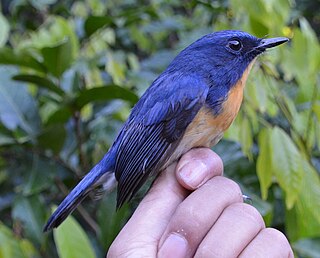
The Meratus blue flycatcher is a species of bird in the Old World flycatcher family, Muscicapidae. The species was described in 2021 by the Indonesian ornithologist Mohammed Irham and his colleagues, based on genetic, morphological, and vocal differences with other Cyornis flycatchers. It is endemic to the Meratus Mountains of Indonesian Borneo, where it has been recorded only from Mount Besar. It is most common at elevations between 900 and 1,300 m and inhabits montane rainforest, secondary forest, and rubber plantations. It is sexually dimorphic like other species in its genus; males have blue upperparts, iridescent blue patches on the forehead and shoulders, and orange-and-white underparts, while females have gray-brown heads and upperparts. They have a length of 15.7–16.0 cm (6.2–6.3 in); males weigh 18.5–19.75 g (0.653–0.697 oz) and females weigh 15.75–20.0 g (0.556–0.705 oz).

The Meratus white-eye is a species of bird in the white-eye family, Zosteropidae. The species was described in 2021 by the Indonesian ornithologist Mohammed Irham and his colleagues based on genetic, morphological, and vocal differences from other Zosterops white-eyes. It is endemic to the Meratus Mountains of Indonesian Borneo, where it has been observed on Mount Besar and Mount Karokangen. It inhabits the mid and lower storeys of closed-canopy montane forests at elevations between 1,300 and 1,650 m. It is a typical Zosterops white-eye, with deep olive-green upperparts, yellower underparts, a yellow stripe across the lores, and a distinctive bicoloured bill. Adults have a length of around 11–12 cm (4.3–4.7 in) and a mass of 8.5–9.5 g (0.30–0.34 oz). Both sexes look alike.
North Putussibau is a district (kecamatan) located in Kapuas Hulu Regency, West Kalimantan, Indonesia.

