Mercer, North Dakota

Last updated

Mercer, North Dakota
Mercer, North Dakota 06-14-2008.jpg
Street scene in Mercer, North Dakota
ND McLean County Mercer.svg
Location of Mercer, North Dakota
Coordinates: 47°29′26″N100°42′38″W / 47.49056°N 100.71056°W / 47.49056; -100.71056
CountryUnited States
State North Dakota
County McLean
Founded1905
Area
[1]
  Total0.23 sq mi (0.59 km2)
  Land0.22 sq mi (0.58 km2)
  Water0.01 sq mi (0.02 km2)
Elevation
[2]
1,926 ft (587 m)
Population
 (2020) [3]
  Total88
  Estimate 
(2022) [4]
113
  Density396.40/sq mi (152.78/km2)
Time zone UTC-6 (Central (CST))
  Summer (DST) UTC-5 (CDT)
ZIP code
58559
Area code 701
FIPS code 38-52340
GNIS feature ID1036159 [2]
Website mercernd.org

Mercer is a city in McLean County, North Dakota, United States. The population was 88 at the 2020 census. [3]

Contents

Mercer was founded in 1905 along a now-abandoned branch line of the Northern Pacific Railway extending from Carrington to Turtle Lake. The name comes from William Henry Harrison Mercer, a well known rancher in the Missouri River Valley for many years and for whom Mercer County is also named. [5]

Geography

The city of Mercer lies on North Dakota Highway 200 between Underwood and McClusky.

According to the United States Census Bureau, the city has a total area of 0.23 square miles (0.60 km2), of which 0.22 square miles (0.57 km2) is land and 0.01 square miles (0.03 km2) is water. [6]

Demographics

Historical population
CensusPop.Note
1950 214
1960 154−28.0%
1970 132−14.3%
1980 1341.5%
1990 104−22.4%
2000 86−17.3%
2010 949.3%
2020 88−6.4%
2022 (est.)113 [4] 28.4%
U.S. Decennial Census [7]
2020 Census [3]

Zion Lutheran Cemetery, Wrought-Iron Cross Site, in or near Mercer, is listed on the National Register of Historic Places.

2010 census

As of the census of 2010, there were 94 people, 48 households, and 24 families residing in the city. The population density was 427.3 inhabitants per square mile (165.0/km2). There were 58 housing units at an average density of 263.6 per square mile (101.8/km2). The racial makeup of the city was 97.9% White, 1.1% Asian, and 1.1% from two or more races.

There were 48 households, of which 25.0% had children under the age of 18 living with them, 41.7% were married couples living together, 6.3% had a female householder with no husband present, 2.1% had a male householder with no wife present, and 50.0% were non-families. 43.8% of all households were made up of individuals, and 29.2% had someone living alone who was 65 years of age or older. The average household size was 1.96 and the average family size was 2.71.

The median age in the city was 53.5 years. 22.3% of residents were under the age of 18; 0% were between the ages of 18 and 24; 14.9% were from 25 to 44; 30.9% were from 45 to 64; and 31.9% were 65 years of age or older. The gender makeup of the city was 51.1% male and 48.9% female.

2000 census

As of the census of 2000, there were 86 people, 49 households, and 22 families residing in the city. The population density was 398.2 inhabitants per square mile (153.7/km2). There were 56 housing units at an average density of 259.3 per square mile (100.1/km2). The racial makeup of the city was 100.00% White.

There were 49 households, out of which 18.4% had children under the age of 18 living with them, 36.7% were married couples living together, 4.1% had a female householder with no husband present, and 55.1% were non-families. 55.1% of all households were made up of individuals, and 32.7% had someone living alone who was 65 years of age or older. The average household size was 1.76 and the average family size was 2.59.

In the city, the population was spread out, with 16.3% under the age of 18, 2.3% from 18 to 24, 20.9% from 25 to 44, 29.1% from 45 to 64, and 31.4% who were 65 years of age or older. The median age was 51 years. For every 100 females, there were 75.5 males. For every 100 females age 18 and over, there were 71.4 males.

The median income for a household in the city was $28,750, and the median income for a family was $46,250. Males had a median income of $48,125 versus $15,000 for females. The per capita income for the city was $18,937. There were 25.0% of families and 25.3% of the population living below the poverty line, including 23.5% who were under eighteen and 34.8% who were over 64.

Related Research Articles

<span class="mw-page-title-main">Kramer, North Dakota</span> City in North Dakota, United States

Kramer is a city in Bottineau County, North Dakota, United States. The population was 24 at the 2020 census. Kramer was founded in 1905.

<span class="mw-page-title-main">Bowman, North Dakota</span> City in North Dakota, United States

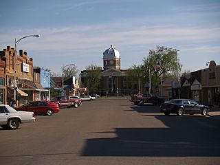
Bowman is a city and county seat of Bowman County, North Dakota, United States. The population was 1,470 at the 2020 census.

<span class="mw-page-title-main">Hunter, North Dakota</span> City in North Dakota, United States

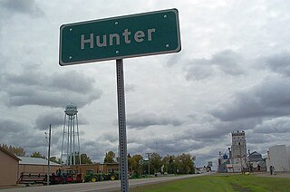
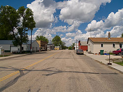
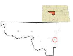
Hunter is a city in Cass County, North Dakota, United States. The population was 332 at the 2020 census. Hunter was founded in 1881.

<span class="mw-page-title-main">Oxbow, North Dakota</span> City in North Dakota, United States

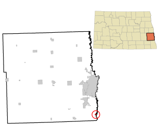
Oxbow is a city in Cass County, North Dakota, United States. The population was 381 at the 2020 census. It is an upscale bedroom community located 15 miles (24 km) south of Fargo. It was incorporated as a city October 25, 1988.

<span class="mw-page-title-main">Ambrose, North Dakota</span> City in North Dakota, United States

Ambrose is a city in Divide County, North Dakota, United States. The population was 24 at the 2020 census. Ambrose was founded in 1906.

<span class="mw-page-title-main">Crosby, North Dakota</span> City in North Dakota

Crosby is a city and the county seat of Divide County, North Dakota, United States. The population was 1,065 at the 2020 census.

<span class="mw-page-title-main">Beulah, North Dakota</span> City in North Dakota, United States

Beulah is a city in Mercer County, North Dakota, United States. The population was 3,058 at the 2020 census. Beulah is home to the Dakota Gasification Company. It is near the largest lignite mine in the United States, owned by North American Coal Corporation.

<span class="mw-page-title-main">Golden Valley, North Dakota</span> City in North Dakota, United States

Golden Valley is a city in Mercer County, North Dakota, United States. The population was 182 at the 2020 census. Golden Valley was founded in 1913.

<span class="mw-page-title-main">Hazen, North Dakota</span> City in North Dakota, United States

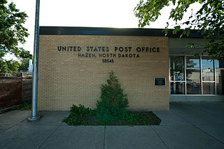
Hazen is a city in Mercer County, North Dakota, United States. The population was 2,281 at the 2020 census. Hazen was founded in 1913. Hazen has a K–12 school system.

<span class="mw-page-title-main">Pick City, North Dakota</span> City in North Dakota, United States

Pick City is a town in Mercer County, North Dakota, United States. The population was 123 at the 2020 census. Pick City was founded in 1946 and named after Lewis A. Pick, director of the Missouri River office of the United States Army Corps of Engineers. It overlooks the Garrison Dam.

<span class="mw-page-title-main">Stanton, North Dakota</span> City in North Dakota, United States

Stanton is a city in Mercer County, North Dakota, United States. It is the county seat of Mercer County. The population was 368 at the 2020 census. Stanton was founded in 1883 and became the county seat when Mercer County organized in 1884.

<span class="mw-page-title-main">Starkweather, North Dakota</span> City in North Dakota, United States

Starkweather is a city in Ramsey County, North Dakota, United States. The population was 100 at the 2020 census. Starkweather was founded in 1902.

<span class="mw-page-title-main">Spiritwood Lake, North Dakota</span> City in North Dakota, United States

Spiritwood Lake is a city in Stutsman County, North Dakota, United States. The population was 97 at the 2020 census.

<span class="mw-page-title-main">Mound City, South Dakota</span> Town in South Dakota, United States

Mound City is a town in and the county seat of Campbell County, South Dakota, United States. The population was 69 at the 2020 census.

<span class="mw-page-title-main">Webster, South Dakota</span> City in South Dakota, United States

Webster is a city in and the county seat of Day County, South Dakota, United States. The population was 1,728 at the 2020 census.

<span class="mw-page-title-main">Big Stone City, South Dakota</span> City in South Dakota, United States

Big Stone City is a city in the northeastern corner of Grant County, South Dakota, United States, that lies between the southern tip of Big Stone Lake and the northern bank of the Whetstone River, and is adjacent to the city of Ortonville, Minnesota. The population was 412 at the 2020 census.

<span class="mw-page-title-main">Crooks, South Dakota</span> City in South Dakota, United States

Crooks is a city in Minnehaha County, South Dakota, United States and is a suburb of Sioux Falls. The population was 1,362 at the 2020 census. Crooks was named New Hope until 1904. The town's present name honors W. A. Crooks, a local politician.

<span class="mw-page-title-main">Conde, South Dakota</span> City in South Dakota, United States

Conde is a city in Spink County, South Dakota, United States. The population was 142 at the 2020 census.

<span class="mw-page-title-main">Mission, South Dakota</span> City in South Dakota, United States

Mission is a city on the Rosebud Indian Reservation in northern Todd County, South Dakota, United States. The population was 1,156 at the 2020 census.

<span class="mw-page-title-main">Dupree, South Dakota</span> City in South Dakota, United States

Dupree is a city in and county seat of Ziebach County, South Dakota, United States. The population was 494 at the 2020 census. It is the only incorporated community located fully within Ziebach County.

References

  1. "ArcGIS REST Services Directory". United States Census Bureau. Retrieved September 20, 2022.
  2. 1 2 U.S. Geological Survey Geographic Names Information System: Mercer, North Dakota
  3. 1 2 3 "Explore Census Data". United States Census Bureau . Retrieved December 14, 2023.
  4. 1 2 "City and Town Population Totals: 2020-2022". United States Census Bureau. December 14, 2023. Retrieved December 14, 2023.
  5. Wick, Douglas A. "Mercer (McLean County)". North Dakota Place Names. Retrieved May 6, 2011.
  6. "US Gazetteer files 2010". United States Census Bureau. Archived from the original on January 25, 2012. Retrieved June 14, 2012.
  7. United States Census Bureau. "Census of Population and Housing" . Retrieved July 19, 2013.