A retroreflector is a device or surface that reflects radiation back to its source with minimum scattering. This works at a wide range of angle of incidence, unlike a planar mirror, which does this only if the mirror is exactly perpendicular to the wave front, having a zero angle of incidence. Being directed, the retroflector's reflection is brighter than that of a diffuse reflector. Corner reflectors and cat's eye reflectors are the most used kinds.

LAGEOS, Laser Geodynamics Satellite or Laser Geometric Environmental Observation Survey, are a series of two scientific research satellites designed to provide an orbiting laser ranging benchmark for geodynamical studies of the Earth. Each satellite is a high-density passive laser reflector in a very stable medium Earth orbit (MEO).

In satellite laser ranging (SLR) a global network of observation stations measures the round trip time of flight of ultrashort pulses of light to satellites equipped with retroreflectors. This provides instantaneous range measurements of millimeter level precision which can be accumulated to provide accurate measurement of orbits and a host of important scientific data. The laser pulse can also be reflected by the surface of a satellite without a retroreflector, which is used for tracking space debris.

Project Echo was the first passive communications satellite experiment. Each of the two American spacecraft, launched in 1960 and 1964, were metalized balloon satellites acting as passive reflectors of microwave signals. Communication signals were transmitted from one location on Earth and bounced off the surface of the satellite to another Earth location.

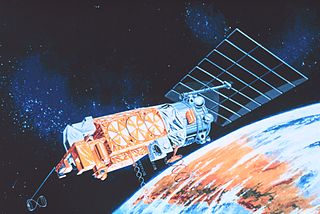
The Meteor spacecraft are weather observation satellites launched by the Soviet Union and Russia. The Meteor satellite series was initially developed during the 1960s. The Meteor satellites were designed to monitor atmospheric and sea-surface temperatures, humidity, radiation, sea ice conditions, snow-cover, and clouds. Between 1964 and 1969, a total of eleven Soviet Union Meteor satellites were launched.
ICESat was a NASA satellite mission for measuring ice sheet mass balance, cloud and aerosol heights, as well as land topography and vegetation characteristics. It operated as part of NASA's Earth Observing System (EOS). ICESat was launched 13 January 2003 on a Delta II launch vehicle from Vandenberg Air Force Base in California into a near-circular, near-polar orbit with an altitude of approximately 600 km (370 mi). It operated for seven years before being retired in February 2010, after its scientific payload shut down and scientists were unable to restart it.

The Earth Radiation Budget Satellite (ERBS) was a NASA scientific research satellite. The satellite was one of three satellites in NASA's research program, named Earth Radiation Budget Experiment (ERBE), to investigate the Earth's radiation budget. The satellite also carried an instrument that studied stratospheric aerosol and gases.

NOAA-17, also known as NOAA-M before launch, was an operational, polar orbiting, weather satellite series operated by the National Environmental Satellite Service (NESS) of the National Oceanic and Atmospheric Administration (NOAA). NOAA-17 also continued the series of Advanced TIROS-N (ATN) spacecraft begun with the launch of NOAA-8 (NOAA-E) in 1983 but with additional new and improved instrumentation over the NOAA A-L series and a new launch vehicle.
The Stratospheric Aerosol and Gas Experiment (SAGE) is a series of remote sensing satellite instruments used to study the chemical composition of Earth's atmosphere. Specifically, SAGE has been used to study the Earth's ozone layer and aerosols at the troposphere through the stratosphere. The SAGE instruments use solar occultation measurement technique to determine chemical concentrations in the atmosphere. Solar occultation measurement technique measures sunlight through the atmosphere and ratios that measurement with a sunlight measurement without atmospheric attenuation. This is achieved by observing sunrises and sunsets during a satellite orbit. Physically, the SAGE instruments measure ultraviolet/visible energy and this is converted via algorithms to determine chemical concentrations. SAGE data has been used to study the atmospheres aerosols, ozone, water vapor, and other trace gases.
NOAA-7, known as NOAA-C before launch, was an American operational weather satellite for use in the National Operational Environmental Satellite System (NOESS) and for the support of the Global Atmospheric Research Program (GARP) during 1978-1984. The satellite design provided an economical and stable Sun-synchronous platform for advanced operational instruments to measure the atmosphere of Earth, its surface and cloud cover, and the near-space environment. An earlier launch, NOAA-B, was scheduled to become NOAA-7, however NOAA-B failed to reach its required orbit.
NOAA-6, known as NOAA-A before launch, was an American operational weather satellite for use in the National Operational Environmental Satellite System (NOESS) and for the support of the Global Atmospheric Research Program (GARP) during 1978-1984. The satellite design provided an economical and stable Sun-synchronous platform for advanced operational instruments to measure the atmosphere of Earth, its surface and cloud cover, and the near-space environment.
NOAA B was an American operational weather satellite for use in the National Operational Environmental Satellite System (NOESS) and for the support of the Global Atmospheric Research Program (GARP) during 1978-1984. The satellite design provided an economical and stable Sun-synchronous platform for advanced operational instruments to measure the atmosphere of Earth, its surface and cloud cover, and the near-space environment.
STSat-2B, or Science and Technology Satellite-2B, was a South Korean satellite which was lost in the failure of the second flight of the Naro-1 launch vehicle. It was to have been operated by the Korea Aerospace Research Institute (KARI), and was intended to demonstrate technology for future spacecraft. The satellite had a mass of 100 kg (220 lb), and was expected to operate for at least two years.

ADEOS I was an Earth observation satellite launched by NASDA in 1996. The mission's Japanese name, Midori means "green". The mission ended in July 1997 after the satellite sustained structural damage to the solar panel. Its successor, ADEOS II, was launched in 2002. Like the first mission, it ended after less than a year, also following solar panel malfunctions.

SAGE III on ISS is the fourth generation of a series of NASA Earth-observing instruments, known as the Stratospheric Aerosol and Gas Experiment. The first SAGE III instrument was launched on a Russian Meteor-3M satellite. The recently revised SAGE III was mounted to the International Space Station where it uses the unique vantage point of ISS to make long-term measurements of ozone, aerosols, water vapor, and other gases in Earth's atmosphere.

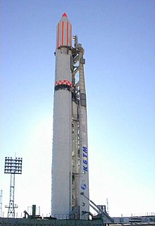
BLITS (Ball Lens In The Space) is a Russian satellite launched on September 17, 2009, as a secondary payload on a Soyuz-2.1b/Fregat, from the Baikonur Cosmodrome in Kazakhstan. The satellite is totally passive and spherical, and is tracked using satellite laser ranging (SLR) by the International Laser Ranging Service. The design of BLITS is based on the optical Luneburg lens concept. The retroreflector is a multilayer glass sphere; it provides uniform reflection characteristics when viewed within a very wide range of angles, and can provide a cross-section sufficient for observations at low to medium orbit heights. A similar design was already tested on a smaller laser reflector carried on board of the METEOR-3M spacecraft launched on December 10, 2001.
TanSat, also known as CarbonSat, is a Chinese Earth observation satellite dedicated to monitoring carbon dioxide in Earth's atmosphere. It is generally classified as a minisatellite, and is the first dedicated carbon mission of the Chinese space program. The mission was formally proposed in 2010, and work began in January 2011. It is funded by the Ministry of Science and Technology (MOST) and was built by the Shanghai Institute of Microsystem And Information Technology (SIMIT).

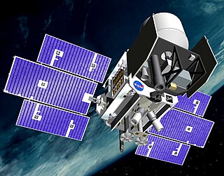
NOAA-20, designated JPSS-1 prior to launch, is the first of the United States National Oceanic and Atmospheric Administration's latest generation of U.S. polar-orbiting, non-geosynchronous, environmental satellites called the Joint Polar Satellite System. NOAA-20 was launched on 18 November 2017 and joined the Suomi National Polar-orbiting Partnership satellite in the same orbit. NOAA-20 operates about 50 minutes behind Suomi NPP, allowing important overlap in observational coverage. Circling the Earth from pole-to-pole, it crosses the equator about 14 times daily, providing full global coverage twice a day. This gives meteorologists information on "atmospheric temperature and moisture, clouds, sea-surface temperature, ocean color, sea ice cover, volcanic ash, and fire detection" so as to enhance weather forecasting including hurricane tracking, post-hurricane recovery by detailing storm damage and mapping of power outages.

Explorer 60, also called as SAGE and was the second of the Applications Explorer Missions (AEM), AEM-B, was a NASA scientific satellite launched on 18 February 1979, from Wallops Flight Facility (WFF) by a Scout D-1 launch vehicle.
NOAA-8, known as NOAA-E before launch, was an American weather satellite operated by the National Oceanic and Atmospheric Administration (NOAA) for use in the National Environmental Satellite Data and Information Service (NESDIS). It was first of the Advanced TIROS-N series of satellites. The satellite design provided an economical and stable Sun-synchronous platform for advanced operational instruments to measure the atmosphere of Earth, its surface and cloud cover, and the near-space environment.