
Nicholas County is a county located in the U.S. state of Kentucky. As of the 2020 census, the population was 7,537. Its county seat is Carlisle, which is also the only incorporated community in the county. Founded in 1799, the county is named for Col. George Nicholas, the "Father of the Kentucky Constitution."

Jackson County is located in the Commonwealth of Kentucky. As of the 2020 census, the population was 12,955. Its county seat is McKee. The county was formed in 1858 from land given by Madison, Estill, Owsley, Clay, Laurel, and Rockcastle counties. It was named for Andrew Jackson, seventh President of the United States. Jackson County became a moist county via a "local-option" referendum in the Fall of 2019 that made the sale of alcoholic beverages in the county seat, McKee, legal.

This is a list of properties and districts in Indiana that are listed on the National Register of Historic Places. There are over 1,900 in total. Of these, 39 are National Historic Landmarks. Each of Indiana's 92 counties has at least two listings.

This is a list of properties and historic districts in Kentucky that are listed on the National Register of Historic Places. There are listings in all of Kentucky's 120 counties.

Fort Boonesborough was a frontier fort in Kentucky, founded by Daniel Boone and his men following their crossing of the Kentucky River on April 1, 1775. The settlement they founded, known as Boonesborough, Kentucky, is Kentucky's second oldest European-American settlement. It served as a major frontier outpost during the American Revolutionary War, and survived into the early 19th century before its eventual abandonment. A National Historic Landmark now administered as part of Fort Boonesborough State Park, the site is one of the best-preserved archaeological sites of early westward expansion by British colonists in that period. It is located in Madison County, Kentucky off Kentucky Route 627.
Eagle Township is one of twelve townships in Boone County, Indiana. As of the 2010 census, its population was 21,977 and it contained 8,231 housing units.

This is a list of the National Register of Historic Places listings in Warren County, Kentucky.

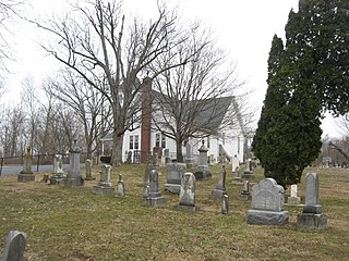
This is a list of the National Register of Historic Places listings in Bracken County, Kentucky.

This is a list of the National Register of Historic Places listings in Boone County, Kentucky.

This is a list of the National Register of Historic Places listings in Trimble County, Kentucky.

This is a list of the National Register of Historic Places listings in Powell County, Kentucky.

This is a list of the National Register of Historic Places listings in Boone County, Indiana.

This is a list of the National Register of Historic Places listings in Bath County, Kentucky.
This is a list of the National Register of Historic Places listings in Menifee County, Kentucky.

This is a list of the National Register of Historic Places listings in Wolfe County, Kentucky.

The Mantle Rock Archeological District, near Smithland, Kentucky is a 215 acres (0.87 km2) historic district which was listed on the National Register of Historic Places in 2004.
The Cleveland-Rogers House, located in what is now Lexington, Kentucky at 8151 Richmond Rd., was listed on the National Register of Historic Places in 1980. Also known as Riverside Farm, the listing included two contributing buildings and a contributing structure.
Boone Creek Rural Historic District, about 11 miles southeast of Lexington, Kentucky, is a 4,060 acres (16.4 km2) historic district which was listed on the National Register of Historic Places in 1994. It included 88 contributing buildings, 55 contributing structures, and 25 contributing sites.
The Pisgah Rural Historic District, in Fayette and Woodford counties near Versailles, Kentucky, is a 4,035 acres (16.33 km2) historic district which was listed on the National Register of Historic Places in 1989.
The Stoner Creek Rural Historic District, in Bourbon County, Kentucky near Paris, Kentucky, is a 22,000 acres (89 km2) historic district which was listed on the National Register of Historic Places in 2001.

