
Hockessin is a census-designated place (CDP) in New Castle County, Delaware, United States. The population was 13,478 at the 2020 Census.

Newark is a small city in New Castle County, Delaware, United States. It is located 12 miles (19 km) west-southwest of Wilmington. According to the 2010 Census, the population of the city is 31,454. Newark is home to the University of Delaware. The city constitutes part of the Delaware Valley.

The East Coast Greenway is a 3,000-mile (4,800 km) pedestrian and bicycle route between Maine and Florida along the East Coast of the United States. The nonprofit East Coast Greenway Alliance was created in 1991 with the goal to use the entire route with off-road, shared-use paths; as of 2021, over 1,000 mi (1,600 km) of the route (35%) meets this criteria. In 2020, the Greenway received over 50 million visits.

Brandywine Creek is a tributary of the Christina River in southeastern Pennsylvania and northern Delaware in the United States. The Lower Brandywine is 20.4 miles (32.8 km) long and is a designated Pennsylvania Scenic River with several tributary streams. The East Branch and West Branch of the creek originate within 2 miles (3 km) of each other on the slopes of Welsh Mountain in Honey Brook Township, Pennsylvania, about 20 miles (32 km) northwest of their confluence.

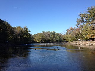
White Clay Creek is an 18.5-mile-long (29.8 km) tributary of the Christina River in southern Pennsylvania and northern Delaware in the United States. It is renowned for its scenic character and is largely federally protected.

Cobbs Creek is an 11.8-mile-long (19.0 km) tributary of Darby Creek in Delaware County, Pennsylvania, in the United States. It forms an approximate border between Montgomery County and Delaware County. After Cobbs Creek passes underneath Township Line Road, it forms the border between Philadelphia County and Delaware County. It runs directly through the two sides of Mount Moriah Cemetery which spans the border of Southwest Philadelphia and Yeadon, Pennsylvania. It later joins Darby Creek before flowing into the Delaware River.

Tohickon Creek is a 29.5-mile-long (47.5 km) tributary of the Delaware River. Located entirely in Bucks County, in southeastern Pennsylvania, it rises in Springfield Township and has its confluence with the Delaware at Point Pleasant. It is dammed to form Lake Nockamixon.
Mill Creek Hundred is an unincorporated subdivision of New Castle County, Delaware. Hundreds were once used as a basis for representation in the Delaware General Assembly, and while their names still appear on all real estate transactions, they presently have no meaningful use or purpose except as a geographical point of reference.
Neshaminy Creek is a 40.7-mile-long (65.5 km) stream that runs entirely through Bucks County, Pennsylvania, rising south of the borough of Chalfont, where its north and west branches join. Neshaminy Creek flows southeast toward Bristol Township and Bensalem Township to its confluence with the Delaware River. The name "Neshaminy" originates with the Lenni Lenape and is thought to mean "place where we drink twice". This phenomenon refers to a section of the creek known as the Neshaminy Palisades, where the course of the water slows and changes direction at almost a right angle, nearly forcing the water back upon itself. These palisades are located in Dark Hollow Park, operated by the county, and are flanked by Warwick Township to the south and Buckingham Township to the north.

Delaware Route 2 (DE 2) is a 10.81-mile-long (17.40 km) east–west state highway located in the northern part of New Castle County in the U.S. state of Delaware. It runs from DE 72 and DE 273 on the eastern edge of Newark east to DE 52 in Wilmington. Between Newark and Wilmington, the route is a four- to six-lane divided highway called Capitol Trail and Kirkwood Highway that passes through suburban areas, running through Marshallton, Prices Corner, and Elsmere. In Wilmington, DE 2 is routed along the one-way pair of Lincoln Street eastbound and Union Street westbound, passing through urban areas.

Delaware Route 7 (DE 7) is a north–south highway in New Castle County, Delaware that connects U.S. Route 13 (US 13) and DE 72 in Wrangle Hill north to the Pennsylvania border near Hockessin, where the road continues into Pennsylvania as State Route 3013 (SR 3013), intersecting Pennsylvania Route 41 (PA 41) at an interchange. Between Wrangle Hill and Christiana, DE 7 runs parallel to the west of the DE 1 freeway through suburban areas, passing through Bear. DE 7 joins DE 1 next to the Christiana Mall and comes to an interchange with Interstate 95 (I-95), where DE 1 reaches its northern terminus, before the freeway ends at the DE 58 interchange. After the freeway segment, DE 7 continues north as an at-grade road concurrent with DE 4 through Stanton. From Stanton to the Pennsylvania border, DE 7 heads northwest through suburban areas, passing through Pike Creek.

White Clay Creek Preserve is a 3,050-acre (1,230 ha) Pennsylvania state park along the valley of White Clay Creek in London Britain Township in Chester County, Pennsylvania in the United States. The park was donated by the DuPont Company in 1984 for the purpose of "preserving the diverse and unique plant and animal species, and the rich cultural heritage of the area". Dupont also donated an additional 528 acres (214 ha) for the adjoining White Clay Creek State Park to the state of Delaware. White Clay Creek Preserve is 3 miles (4.8 km) north of Newark, Delaware on Pennsylvania Route 896.

White Clay Creek State Park is a Delaware state park along White Clay Creek on 3,647 acres (1,476 ha) in New Castle County, near Newark, Delaware in the United States. North of the park is Pennsylvania's White Clay Creek Preserve, and the two were originally operated as bi-state parks to jointly protect the creek, but now they operate separately. The White Clay Creek is federally protected as part of the National Park Service's National Wild and Scenic Rivers System. White Clay Creek State Park offers 37 miles (60 km) of nature and fitness trails which are open to hiking and mountain biking 365 days a year with access at a number of seasonal day-use fee parking lots. Fee season is in effect March 1 - November 30. Fees are $4 for in-state vehicle or $8 for out of state vehicles. Annual passes can be purchased at any DE State Park Office or online. The park also preserves a number of historic structures and operates a nature center. It is part of the Northeastern coastal forests ecoregion.

Delaware Route 4 (DE 4) is a state highway in New Castle County, Delaware. The route runs from DE 279 and DE 896 in Newark east to DE 48 in downtown Wilmington. The route passes through suburban areas in northern New Castle County between Newark and Wilmington, intersecting DE 72 in the eastern part of Newark, DE 273 in Ogletown, DE 58 in Christiana, DE 7 in Stanton, DE 141 in Newport, DE 62 and DE 100 between Newport and Wilmington, and Interstate 95 (I-95)/U.S. Route 202 (US 202) in Wilmington. DE 4 is a four-lane road for much of its length.

Delaware Route 72 (DE 72) is a state highway located in New Castle County, Delaware. The route runs from DE 9 near Delaware City north to DE 7 in Pike Creek. The highway runs through suburban areas of northern New Castle County, passing through the eastern part of Newark. DE 72 intersects U.S. Route 13 (US 13), DE 7, and DE 1 near Delaware City, DE 71 in Williamsburg, US 40 east of Glasgow, and DE 4, DE 2, and DE 273 in Newark. Parts of DE 72 were built as a state highway during the 1930s. By the 1940s, the route was designated from DE 2 in Newark north to DE 7 in Pike Creek along Paper Mill Road. The route was extended south to DE 9 in the 1960s. In 1980, the alignment was shifted to the east through Newark to bypass an at-grade railroad crossing on Chapel Street.
The Lenape Trail is a trail through Essex County, connecting many county parks and reservations, wooded spaces, and historical sites. It begins in Newark, New Jersey and ends in Millburn, New Jersey. It was established in 1982. It is the fifth longest trail in the state behind the Delaware and Raritan Canal Trail, the Appalachian Trail, the completed section of the Highlands Trail in the state and the Batona Trail. The Lenape trail traverses Newark and its suburbs, as well as the Watchung Mountains and Passaic Meadows. Because of the steepness of the Watchung Mountains and the flood-prone nature of the Passaic Meadows, the former basin of Glacial Lake Passaic, these areas have remained much less developed than the rest of the northeastern part of the state. This trail therefore offers hikers an opportunity to see cultural and historical sites of an urban trail, as well as large natural and undeveloped areas. The trail's proximity to New York City and the various ridges it traverses, including Forest Hill, Orange Mountain, and Second Watchung Mountain, offer many views of the skyline. The Lenape Trail forms a segment of the Liberty-Water Gap Trail and incorporates the West Essex Trail, the Lenape Trail's only rail-to-trail section. The Lenape Trail also connects with Morris County's Patriots Path trail system on its western terminus.
The Pomeroy and Newark Railroad was a predecessor of the Pennsylvania Railroad in the U.S. states of Delaware and Pennsylvania. It connected Pomeroy, Pennsylvania to Newark, Delaware, and has mostly been abandoned.
Stanton is an unincorporated community in New Castle County, Delaware, United States, near the confluence of the Red Clay and White Clay Creeks. It is located in the southern end of Mill Creek Hundred.

White Clay Creek Presbyterian Church is a historic Presbyterian church located near Newark, New Castle County, Delaware. The current structure was built in 1855, and is a two-story brick structure, nearly as tall as it is wide. The building measures 63 feet deep. The exterior features brick pilasters and tall stained glass windows. A 1996 addition to the front of the building contains an elevator to the second floor sanctuary and is topped by a steeple. It was preceded by a structure built in 1752. The church was organized as early as 1709 to serve Scotch-Irish Presbyterians at White Clay Creek. The original White Clay Creek Presbyterian Church was built in 1721 about a mile north on the NW Corner of Dewalt Rd and Old Coach Rd. It remains the Old White Clay Creek Presbyterian Church Cemetery.


