Middlesex Township, Butler County, Pennsylvania

Last updated

Middlesex Township,Butler County, Pennsylvania
Municipal Building, Middlesex Township, Butler County, Pennsylvania.jpg
Municipal Building at 133 Browns Hill Road, Valencia
Map of Middlesex Township, Butler County, Pennsylvania Highlighted.png
Map of Butler County, Pennsylvania, highlighting Middlesex Township
Map of Pennsylvania highlighting Butler County.svg
Map of Butler County, Pennsylvania
Country United States
State Pennsylvania
County Butler
Settled1795
Incorporated1800
Area
[1]
  Total23.22 sq mi (60.13 km2)
  Land23.14 sq mi (59.95 km2)
  Water0.07 sq mi (0.19 km2)
Population
 (2020) [2]
  Total6,826
  Estimate 
(2022) [2]
7,338
  Density243.34/sq mi (93.95/km2)
Time zone UTC-5 (Eastern (EST))
  Summer (DST) UTC-4 (EDT)
FIPS code42-019-49056
Website www.middlesextownship.org

Middlesex Township is a township in Butler County, Pennsylvania, United States. The population was 6,826 at the 2020 census. [2]

Contents

Geography

Middlesex Township is located in south-central Butler County, with Allegheny County to the south. The unincorporated communities of Cooperstown and Glade Mills are near the center of the township along Pennsylvania Route 8, which crosses the township from north to south.

According to the United States Census Bureau, the township has a total area of 23.2 square miles (60.1 km2), of which 23.1 square miles (59.9 km2) is land and 0.077 square miles (0.2 km2), or 0.31%, is water. [3]

Streams

Deer Creek and Bull Creek have their headwaters in the southeastern section of the township, whence they flow south to the Allegheny River in Allegheny County. [4]

Demographics

Historical population
CensusPop.Note
2010 5,390
2020 6,82626.6%
2022 (est.)7,338 [2] 7.5%
U.S. Decennial Census [5]

As of the 2000 census, [6] there were 5,586 people, 2,045 households, and 1,615 families residing in the township. The population density was 243.2 inhabitants per square mile (93.9/km2). There were 2,105 housing units at an average density of 91.7 per square mile (35.4/km2). The racial makeup of the township was 98.89% White, 0.25% African American, 0.09% Native American, 0.16% Asian, 0.02% Pacific Islander, 0.20% from other races, and 0.39% from two or more races. Hispanic or Latino of any race were 0.68% of the population.

There were 2,045 households, out of which 37.3% had children under the age of 18 living with them, 68.8% were married couples living together, 7.2% had a female householder with no husband present, and 21.0% were non-families. 18.1% of all households were made up of individuals, and 8.0% had someone living alone who was 65 years of age or older. The average household size was 2.73 and the average family size was 3.12.

In the township the population was spread out, with 27.2% under the age of 18, 5.7% from 18 to 24, 28.5% from 25 to 44, 25.7% from 45 to 64, and 12.8% who were 65 years of age or older. The median age was 40 years. For every 100 females, there were 97.1 males. For every 100 females age 18 and over, there were 96.4 males.

The median income for a household in the township was $49,743, and the median income for a family was $56,199. Males had a median income of $40,827 versus $28,342 for females. The per capita income for the township was $23,508. About 3.4% of families and 3.9% of the population were below the poverty line, including 4.3% of those under age 18 and 4.6% of those age 65 or over.

Education

Middlesex Township is within the Mars Area School District. The district consists of Mars Area Primary Center, Mars Area Elementary School, Mars Area Centennial School, Mars Area Middle School, and Mars Area High School.

Related Research Articles

<span class="mw-page-title-main">Marshall Township, Pennsylvania</span> Township in Pennsylvania, United States

Marshall Township is a township that is located in Allegheny County, Pennsylvania, United States. The population was 10,080 at the time of the 2020 census.

<span class="mw-page-title-main">Pine Township, Allegheny County, Pennsylvania</span> Township in Pennsylvania, United States

Pine Township is a township that is located in Allegheny County, Pennsylvania, United States. The population was 14,691 at the time of the 2020 census.

<span class="mw-page-title-main">Richland Township, Allegheny County, Pennsylvania</span> Township in Pennsylvania, United States

Richland Township is a township in Allegheny County, Pennsylvania, United States. The population was 11,942 at the 2020 census.

<span class="mw-page-title-main">Springdale Township, Pennsylvania</span> Township in Pennsylvania, United States

Springdale Township is a township in Allegheny County, Pennsylvania, United States. It contains the two communities of Orrville and Harwick. The population was 1,636 at the 2010 census.

<span class="mw-page-title-main">Hovey Township, Armstrong County, Pennsylvania</span> Township in Pennsylvania, United States

Hovey Township is a township which is located in far northern Armstrong County, Pennsylvania, United States. The population was seventy-four at the time of the 2020 census, a decrease from the figure of 97 tabulated in 2010.

<span class="mw-page-title-main">South Buffalo Township, Pennsylvania</span> Township in Pennsylvania, United States

South Buffalo Township is a township in Armstrong County, Pennsylvania, United States. The population was 2,713 at the 2020 census, an increase from the figure of 2,636 tabulated in 2010.

<span class="mw-page-title-main">West Franklin Township, Pennsylvania</span> Township in Pennsylvania, United States

West Franklin Township is a township in Armstrong County, Pennsylvania, United States. The population was 1,709 at the 2020 census, a decline from the figure of 1,853 tabulated in 2010.

<span class="mw-page-title-main">Allegheny Township, Blair County, Pennsylvania</span> Township in Pennsylvania, United States

Allegheny Township is a township in Blair County, Pennsylvania, United States. The population was 6,585 at the 2020 census. It is part of the Altoona, Pennsylvania Metropolitan Statistical Area.

<span class="mw-page-title-main">Adams Township, Butler County, Pennsylvania</span> Township in Pennsylvania, United States

Adams Township in Butler County, Pennsylvania, United States, is a township that had population of 14,841 at the 2020 census.

<span class="mw-page-title-main">Allegheny Township, Butler County, Pennsylvania</span> Township in Pennsylvania, United States

Allegheny Township is a township in Butler County, Pennsylvania, United States. The population was 624 at the 2020 census.

<span class="mw-page-title-main">Buffalo Township, Butler County, Pennsylvania</span> Township in Pennsylvania, United States

Buffalo Township is a township in Butler County, Pennsylvania, United States. The population was 7,896 at the 2020 census.

<span class="mw-page-title-main">Clinton Township, Butler County, Pennsylvania</span> Township in Pennsylvania, United States

Clinton Township is a township in Butler County, Pennsylvania, United States. The population was 2,913 at the 2020 census. For generations, it was home to a U.S. Steel plant.

<span class="mw-page-title-main">Forward Township, Butler County, Pennsylvania</span> Township in Pennsylvania, United States

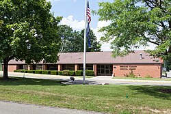
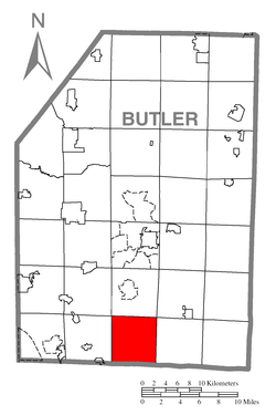
Forward Township is a township in Butler County, Pennsylvania, United States. The population was 3,164 at the 2020 census.

<span class="mw-page-title-main">Mars, Pennsylvania</span> Borough in Pennsylvania, United States

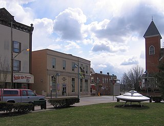
Mars is a borough in southern Butler County, Pennsylvania, United States. The population was 1,458 at the 2020 census. It is part of the Pittsburgh metropolitan area.

<span class="mw-page-title-main">Parker Township, Pennsylvania</span> Township in Pennsylvania, United States

Parker Township is a township that is located in Butler County, Pennsylvania, United States. The population was 574 at the time of the 2020 census.

<span class="mw-page-title-main">Seven Fields, Pennsylvania</span> Place in Pennsylvania, United States

Seven Fields is a borough in Butler County, Pennsylvania, United States. The population was 2,887 at the 2010 census, an increase from the figure of 1,986 tabulated in 2000.

<span class="mw-page-title-main">Valencia, Pennsylvania</span> Borough in Pennsylvania, United States

Valencia is a borough in Butler County, Pennsylvania, United States. The population was 551 at the 2010 census.

<span class="mw-page-title-main">Venango Township, Butler County, Pennsylvania</span> Township in Pennsylvania, United States

Venango Township is a township that is located in Butler County, Pennsylvania, United States. The population was 869 at the time of the 2020 census.

<span class="mw-page-title-main">Richland Township, Clarion County, Pennsylvania</span> Township in Pennsylvania, United States

Richland Township is a township in Clarion County, Pennsylvania, United States. The population was 473 at the 2020 census, a decrease from the figure of 494 tabulated in 2010.

<span class="mw-page-title-main">Harrison Township, Allegheny County, Pennsylvania</span> Township in Pennsylvania, United States

Harrison Township is a township in Allegheny County in the U.S. state of Pennsylvania. The population was 10,169 at the 2020 census. Pennsylvania Route 28 passes through Harrison Township, connecting Kittanning to the northeast and Pittsburgh to the southwest. Allegheny Technologies has extensive steel mill facilities in Harrison Township, including its Allegheny Ludlum Brackenridge Works. Harrison Township is located at the far northeast corner of Allegheny County. Its northern border is the Butler County line and the Allegheny River forms the township's eastern boundary with Westmoreland County. Its northeast corner also touches Armstrong County.

References

  1. "2016 U.S. Gazetteer Files". United States Census Bureau. Retrieved August 13, 2017.
  2. 1 2 3 4 Bureau, US Census. "City and Town Population Totals: 2020-2022". Census.gov. US Census Bureau. Retrieved June 20, 2023.
  3. "Geographic Identifiers: 2010 Demographic Profile Data (G001): Middlesex township, Butler County, Pennsylvania". U.S. Census Bureau, American Factfinder. Archived from the original on February 12, 2020. Retrieved April 1, 2014.
  4. "Deer Creek". Geographic Names Information System . United States Geological Survey, United States Department of the Interior . Retrieved December 20, 2010.
  5. "Census of Population and Housing". Census.gov. Retrieved June 4, 2016.
  6. "U.S. Census website". United States Census Bureau . Retrieved January 31, 2008.

40°41′57″N79°55′28″W / 40.69917°N 79.92444°W / 40.69917; -79.92444