
Tenleytown is a historic neighborhood in Northwest, Washington, D.C.

Anacostia is a historic neighborhood in Washington, D.C. Its downtown is located at the intersection of Good Hope Road and Martin Luther King Jr. Avenue. It is located east of the Anacostia River, after which the neighborhood is named. Like the other quadrants of Washington, D.C., Southeast encompasses many named neighborhoods, of which Anacostia is the most well known. Anacostia includes all of the Anacostia Historic District that was listed on the National Register of Historic Places in 1978. Often the name Anacostia is incorrectly used to refer to the entire portion of the city that is southeast of the Anacostia River. The Anacostia Business Improvement District is responsible for the development of the area.

Fort Monroe, managed by partnership between the Fort Monroe Authority for the Commonwealth of Virginia, the National Park Service as the Fort Monroe National Monument, and the City of Hampton, is a former military installation in Hampton, Virginia, at Old Point Comfort, the southern tip of the Virginia Peninsula, United States. Along with Fort Wool, Fort Monroe originally guarded the navigation channel between the Chesapeake Bay and Hampton Roads—the natural roadstead at the confluence of the Elizabeth, the Nansemond and the James rivers. Until disarmament in 1946, the areas protected by the fort were the entire Chesapeake Bay and Potomac River regions, including the water approaches to the cities of Washington, D.C. and Baltimore, Maryland, along with important shipyards and naval bases in the Hampton Roads area. Surrounded by a moat, the six-sided bastion fort is the largest fort by area ever built in the United States.

16th Street Northwest is a prominent north–south thoroughfare in the northwest quadrant of Washington, D.C. Part of Pierre L'Enfant's design for the city, 16th Street begins just north of the White House across Lafayette Park at H Street and continues due north in a straight line passing K Street, Scott Circle, Meridian Hill Park, Rock Creek Park, and the Walter Reed Army Medical Center before crossing Eastern Avenue into Silver Spring, Maryland, where it ends at Georgia Avenue. From K Street to the District line, 16th Street is part of the National Highway System. The Maryland portion of the street is designated Maryland State Highway 390. The entire street is 6.4 miles (10.3 km) long.

Petworth is a residential neighborhood in the Northwest quadrant of Washington, D.C. It is bounded to the east by the Armed Forces Retirement Home and Rock Creek Cemetery, to the west by Arkansas Avenue NW, to the south by Rock Creek Church Road NW and Spring Road NW, and to the north by Kennedy Street NW.

Brightwood is a neighborhood located in the northwestern quadrant of Washington, D.C. Brightwood is part of Ward 4.

Fort Lesley J. McNair is a United States Army post located on the tip of Greenleaf Point, the peninsula that lies at the confluence of the Potomac River and the Anacostia River in Washington, D.C. To the peninsula's west is the Washington Channel, while the Anacostia River is on its south side. Originally named Washington Arsenal, the fort has been an army post for more than 200 years, third in length of service, after the United States Military Academy at West Point and the Carlisle Barracks. The fort is currently named for General Lesley J. McNair, who was killed in action by friendly fire in Normandy, France during World War II.
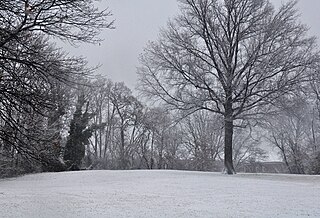
Fort Reno Park is an urban park in the Tenleytown neighborhood of Northwest Washington, D.C. It is named after Fort Reno, one of the only locations in the District of Columbia to see combat during the American Civil War. The park was established in the 1920s to clear an African American neighborhood called Reno from the site, in what was becoming an affluent white suburban area.
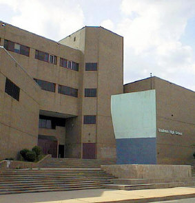
Southern High School was a former public secondary school on Warren Avenue between William Street to the west and Riverside Avenue to the east, in the Federal Hill neighborhood of the northern side of the larger old South Baltimore community on the Whetstone Point peninsula. With historic Fort McHenry from the War of 1812 (1812-1815), to the southeast at the point itself and additional residential areas surrounding the high school in tightly packed rowhouses and streets known as Locust Point and Riverside to the south and southeast along with the restored Otterbein and Sharp-Leadenhall neighborhoods to the west, also just south of the downtown central business district and famed "Inner Harbor" of the City of Baltimore, in Maryland.
Washington Park is a historically black neighborhood in northwest Atlanta encompassing historic residential, commercial, and community landmark buildings. It is situated two miles (3 km) west of the central business district of Atlanta. The combination of gridiron and curvilinear streets is a result of the neighborhood having been developed from four separate subdivision plats. One of these plats created Atlanta's first planned black neighborhood, while the other three were abandoned by white developers and adopted by Heman Perry, an early 20th-century black developer. Although Perry did not receive a formal education past the seventh grade, in 1913 he founded one of the largest black-owned companies in the United States, the Standard Life Insurance Company of Atlanta.

The Oscar W. Underwood House is a historic house located in the Foggy Bottom neighborhood Northwest, Washington, D.C. It is nationally significant for its association with Major Archibald Butt, and painter Francis Davis Millet – both of whom died in the Titanic disaster on April 15, 1912 – and also Alabama politician Oscar Underwood (1862–1929) who lived there 1914–1925. It was the first long-term home of the Washington College of Law, the nation's first law school founded and run by women. The property was declared a National Historic Landmark in 1976. The building presently houses a legal aid clinic operated by George Washington University.

The Mary Church Terrell House is a historic house at 326 T Street NW in Washington, D.C. It was a home of civil rights leader Mary Church Terrell (1863-1954), the first black woman to serve on an American school board, and a leading force in the desegregation of public accommodations in the nation's capital. Her home in the LeDroit Park section of Washington, DC was declared a National Historic Landmark in 1975. The building is a contributing property in the LeDroit Park Historic District.
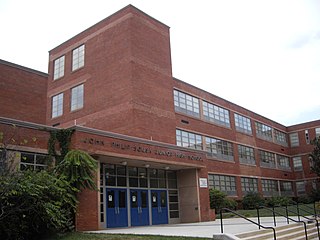
The John Philip Sousa Middle School, formerly the John Philip Sousa Junior High School, is a public school located at 3650 Ely Place in SE area of Washington, D.C. Located in the city's Fort Dupont neighborhood, it serves grades 6-8. Its school building, built in 1950, was the scene of civil rights action not long after its construction. Twelve black students were denied admission to the all-white school. This action was eventually overturned in the landmark 1954 Supreme Court decision in Bolling v. Sharpe, which made segregated public schools illegal in the District of Columbia. The defeat of the legal doctrine "separate but equal" marked an early victory in the modern Civil Rights Movement. The school was declared a National Historic Landmark in 2001 for its role in this action.

The Anacostia Historic District is a historic district in the city of Washington, D.C., comprising approximately 20 squares and about 550 buildings built between 1854 and 1930. The Anacostia Historic District was added to the National Register of Historic Places in 1978. "The architectural character of the Anacostia area is unique in Washington. Nowhere else in the District of Columbia does there exist such a collection of late-19th and early-20th century small-scale frame and brick working-class housing."

The Emory Place Historic District is a historic district in Knoxville, Tennessee, United States, located just north of the city's downtown area. The district consists of several commercial, residential, religious, and public buildings that developed around a late nineteenth century train and trolley station. The district includes the Knoxville High School building, St. John's Lutheran Church, First Christian Church, and some of the few surviving rowhouses in Knoxville. The district was listed on the National Register of Historic Places in 1994.

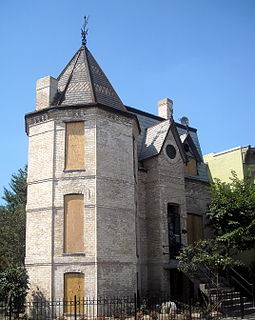
The Reno School is a historic school building located at 4820 Howard Street NW, completed in 1903 to serve the needs of the Reno community in Washington, D.C. Like all public schools in the District at the time, it was segregated and served African American students in the area west of Rock Creek Park and north of Georgetown. The school was closed in 1950 after the Reno community was evicted to create Fort Reno Park and the adjacent Alice Deal Middle School.
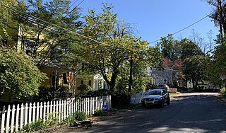
The Grant Road Historic District is located in the Tenleytown neighborhood of Washington, D.C.. The two-block historic district is what remains of a former settlement in rural Washington County in the District of Columbia. It includes 13 contributing buildings and the road itself, a narrow remnant of a country road that was used by soldiers in the Civil War. Following the war, the road was named after Civil War general and President Ulysses S. Grant. Grant Road developed into a residential street lined with mostly small, two-story homes for working-class people.
Frelinghuysen University was a university in Washington, D.C., "devoted in perpetuo to Education of Colored Adults". It "aim[ed] to meet some of the educational needs and demands of colored working folk who are past the age of public school advantages and unable for obvious reasons to meet the requirements of a full day-time college or university." Its classes met outside of business hours; it offered "part-time adult schooling".

Vare-Washington School, is a K-8 school in South Philadelphia, Pennsylvania. It is a part of the School District of Philadelphia. It occupies the former George Washington School building in the Dickinson Narrows neighborhood, in proximity to Southwark.

Four Corners is a neighborhood located in Montgomery County, Maryland, United States. Many residents of Four Corners consider the neighborhood to be a part of Silver Spring. The United States Census Bureau defines Four Corners as a distinct census-designated place (CDP). Prior to 2010, it was defined as a part of the Silver Spring CDP. Four Corners has a population of 8,316 as of the 2020 census.

