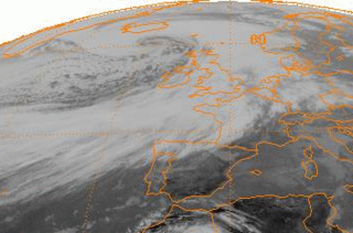
A nor'easter, is a large-scale extratropical cyclone in the western North Atlantic Ocean. The name derives from the direction of the winds that blow from the northeast. The term is commonly used in the winter in New England and Atlantic Canada.
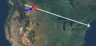
An Alberta clipper, also known as an Alberta low, Alberta cyclone, Alberta lee cyclone, Canadian clipper, or simply clipper, is a fast-moving low-pressure system that originates in or near the Canadian province of Alberta just east of the Rocky Mountains and tracks east-southeastward across southern Canada and the northern United States to the North Atlantic Ocean.

The 2004 Christmas Eve United States winter storm was a rare weather event that took place in Louisiana and Texas in the United States on December 24, 2004, before the storm moved northeast to affect the coastal sections of the Mid-Atlantic states and New England in the succeeding few days. This was a different storm from the historic event that struck the Midwest and southern Canada around December 23 from another cyclone which preceded this storm. The event involved a thin band of snowfall with unusually cold temperatures for the middle Texas coast, and caused dozens of varied weather records to be shattered. It was the most significant snow for the Texas Gulf Coast, and deep South Texas, since February 1895.

The characteristics of United States rainfall climatology differ significantly across the United States and those under United States sovereignty. Summer and early fall bring brief, but frequent thundershowers and tropical cyclones which create a wet summer and drier winter in the eastern Gulf and lower East Coast. During the winter, and spring, Pacific storm systems bring Hawaii and the western United States most of their precipitation. Low pressure systems moving up the East Coast and through the Great Lakes, bring cold season precipitation to from the Midwest to New England, as well as Great Salt Lake. The snow to liquid ratio across the contiguous United States averages 13:1, meaning 13 inches (330 mm) of snow melts down to 1 inch (25 mm) of water.
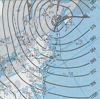
Explosive cyclogenesis is the rapid deepening of an extratropical cyclonic low-pressure area. The change in pressure needed to classify something as explosive cyclogenesis is latitude dependent. For example, at 60° latitude, explosive cyclogenesis occurs if the central pressure decreases by 24 millibars (0.71 inHg) or more in 24 hours. This is a predominantly maritime, winter event, but also occurs in continental settings. This process is the extratropical equivalent of the tropical rapid deepening. Although their cyclogenesis is entirely different from that of tropical cyclones, bomb cyclones can produce winds of 74 to 95 mph, the same order as the first categories of the Saffir–Simpson scale, and yield heavy precipitation. Even though only a minority of bomb cyclones become this strong, some weaker ones can also cause significant damage.

A Gulf low or Texas Low is a low pressure area that forms or intensifies over the Gulf of Mexico and moves northeast on the western side of the Appalachian mountains and sometimes on the Atlantic coast to become a nor'easter. Because they move from over or near the Gulf of Mexico, these storm systems are capable of transporting copious amounts of moisture with them. At their strongest, these storm systems are even more potent snowfall producers than panhandle hooks, primarily because of the mixing of Atlantic Ocean moisture into the storm system once they cross the Appalachian Mountains. Because of the general west to east movement of weather systems in the mid latitudes of the northern hemisphere, Gulf Lows rarely affect areas west of the Mississippi River. One such exception was the Halloween Blizzard of 1991.

The December 2003 New England snowstorm was a severe nor'easter that impacted the Eastern United States during the first week of the month. It produced heavy snowfall throughout the New England and Mid-Atlantic regions, exceeding 40 inches (100 cm) in northern New England. The cyclone had complex origins, involving several individual weather disturbances. An area of low pressure primarily associated with the southern branch of the jet stream spread light precipitation across portions of the Midwest and Southeast. The low reached the coast on December 5 and continued to produce snow throughout the Mid-Atlantic. Another system involving the northern branch of the jet stream merged with the initial storm, causing another coastal storm to develop. This storm soon became the primary feature as it intensified and moved northeastward. It reached Cape Cod on December 6, but became nearly stationary through the morning of December 7. It had finally dissipated by December 8.
The February 1995 nor'easter was a significant nor'easter that impacted the Mid-Atlantic and New England regions of the United States around the beginning of the month. It was the only major nor'easter of the 1994–1995 winter.
The February 1987 nor'easter was a significant winter storm in the US that impacted the Mid-Atlantic States around the end of the month. It delivered 8–12 hours of heavy, wet snowfall to several states from West Virginia to New York between February 22 and February 24. The storm was both preceded and followed by relatively warm temperatures, causing the snow to rapidly melt. The mild conditions were the result of a moderate anticyclone over the region that deteriorated as the nor'easter approached. Cold air damming likely took place prior to the storm's formation.

The February 1952 nor'easter was a significant winter storm that impacted the New England region of the United States. The storm ranked as Category 1, or "notable", on the Northeast Snowfall Impact Scale. Its rapid intensification resulted in heavy snowfall between February 17 and 18, accumulating to 12 to 30 inches. High winds also affected central and northern New England. The nor'easter is estimated to have caused 42 fatalities. In Maine, over 1,000 travelers became stranded on roadways. Two ships cracked in two offshore New England during the storm.

The January 1961 nor'easter was a significant winter storm that impacted the Mid-Atlantic and New England regions of the United States. It was the second of three major snowstorms during the 1960–1961 winter. The storm ranked as Category 3, or "major", on the Northeast Snowfall Impact Scale.

The December 1969 nor'easter was a strong winter storm that mainly affected the Northeastern United States and southern Quebec between December 25 and December 28, 1969. The multi-faceted storm system included a tornado outbreak, record snow accumulations, a damaging ice storm, and flooding rains.
Pacific Northwest windstorms, sometimes colloquially known as Big Blows, are extratropical cyclones which form in the Pacific basin, and affect land areas in the Pacific Northwest of the United States and British Columbia, Canada. They form as cyclonic windstorms associated with areas of low atmospheric pressure that track across the North Pacific Ocean towards western North America. Deep low pressure areas are relatively common over the North Pacific. They are most common in the winter months. On average, the month when most windstorms form is November or December.

The 2013–14 North American winter was one of the most significant for the United States, due in part to the breakdown of the polar vortex in November 2013, which allowed very cold air to travel down into the United States, leading to an extended period of very cold temperatures. The pattern continued mostly uninterrupted throughout the winter and numerous significant winter storms affected the Eastern United States, with the most notable one being a powerful winter storm that dumped ice and snow in the Southeastern United States and the Northeastern United States in mid-February. Most of the cold weather abated by the end of March, though a few winter storms did affect the Western United States towards the end of the winter.

The 2012–13 North American winter started out somewhat early, as the remnants of Hurricane Sandy brought heavy snow to the mountains of West Virginia in late October. Later, a strong nor'easter affected the weary Northeastern United States, hampering storm recovery efforts and dropping several inches of snow. The rest of the winter featured several other notable events, such as a Christmas winter storm that affected most of the Eastern United States, and the most notable event occurring in early February, when a powerful blizzard struck the Northeast and brought record snow to some areas. During the winter, a weak El Nino was expected to influence weather conditions across the continent.

The 2010–11 North American winter was influenced by an ongoing La Niña, seeing winter storms and very cold temperatures affect a large portion of the Continental United States, even as far south as the Texas Panhandle. Notable events included a major blizzard that struck the Northeastern United States in late December with up to 2 feet (24 in) of snowfall and a significant tornado outbreak on New Year's Eve in the Southern United States. By far the most notable event was a historic blizzard that impacted areas from Oklahoma to Michigan in early February. The blizzard broke numerous snowfall records, and was one of the few winter storms to rank as a Category 5 on the Regional Snowfall Index. In addition, Oklahoma set a statewide low temperature record in February.

The 2017–18 North American winter saw weather patterns across North America that were very active, erratic, and protracted, especially near the end of the season, resulting in widespread snow and cold across the continent during the winter. Significant events included rare snowfall in the South, an outbreak of frigid temperatures that affected the United States during the final week of 2017 and early weeks of January, and a series of strong nor'easters that affected the Northeastern United States during the month of March. In addition, flooding also took place during the month of February in the Central United States. Finally the winter came to a conclusion with a powerful storm system that caused a tornado outbreak and blizzard in mid-April. The most intense event, however, was an extremely powerful cyclonic blizzard that impacted the Northeastern United States in the first week of 2018. Similar to the previous winter, a La Niña was expected to influence the winter weather across North America.

The 2020–21 North American winter was the most significant winter season to affect North America in several years, and the costliest on record, with a damage total of at least $33.35 billion. The season featured 6 storms ranking on the Regional Snowfall Index scale, with 4 storms ranking as at least a Category 3. Most of the winter's damage and fatalities occurred due to a historic and major cold wave in mid-February. Several other significant events occurred, including a crippling early-season ice storm in the Southern Plains, a powerful nor'easter in mid-December, another major nor'easter in early February, two major and widespread winter storms in mid-February, and a major blizzard in the Rocky Mountains in mid-March. The winter-related events were responsible for at least 358 fatalities, making it the deadliest season since 1992–93. A La Niña pattern influenced much of the winter in North America.
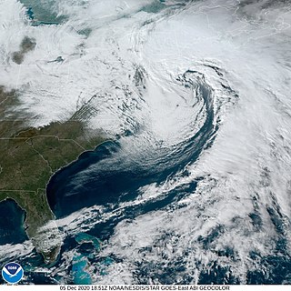
The December 5–6, 2020 nor'easter brought heavy snowfall, hurricane-force wind gusts, blizzard conditions, and coastal flooding to much of New England in the first few days of December 2020. The system originated on the Mid-Atlantic coast late on December 4. It then moved up the East Coast of the United States from December 5–6, bombing out and bringing heavy wet snow to the New England states. It brought up to 18 inches (46 cm) of snow in northern New England, with widespread totals of 6–12 inches (15–30 cm) farther south.

The February 6–8, 2021 nor'easter, also referred to as the 2021 Super Bowl Sunday nor'easter, was a strong and fast-moving nor'easter that started out in the Southern United States, before impacting the Mid-Atlantic and New England states on Super Bowl Sunday, in February 2021. The storm struck the region just days after another significant nor'easter impacted the same general regions. Developing on February 6 along a stationary front in the Southern United States and moving northeastward, the imminent impacts from the nor'easter forced several vaccination sites in the Northeast to temporarily close again for the following days. The storm caused one indirect death, and damage estimates are currently undetermined. It was unofficially named Winter Storm Quade by The Weather Channel.