
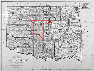
The Indian Territory and the Indian Territories are terms that generally described an evolving land area set aside by the United States Government for the relocation of Native Americans who held aboriginal title to their land as a sovereign independent state. In general, the tribes ceded land they occupied in exchange for land grants in 1803. The concept of an Indian Territory was an outcome of the US federal government's 18th- and 19th-century policy of Indian removal. After the American Civil War (1861–1865), the policy of the US government was one of assimilation.

McCurtain County is in the southeastern corner of the U.S. state of Oklahoma. As of the 2010 census, the population was 33,151. Its county seat is Idabel. It was formed at statehood from part of the earlier Choctaw Nation in Indian Territory. The name honors an influential Choctaw family that lived in the area. Green McCurtain was the last chief when Oklahoma became a state in 1907.

Le Flore County is a county located along the eastern border of the U.S state of Oklahoma. As of the 2010 census, the population was 50,384. Its county seat is Poteau. The county name honors a Choctaw family named LeFlore, which is part of the Fort Smith metropolitan area. The United States District Court for the Eastern District of Oklahoma is the federal district court with jurisdiction in Le Flore County.

The Chickasaw are an indigenous people of the Southeastern Woodlands. Their traditional territory was in the Southeastern United States of Mississippi, Alabama, and Tennessee. Their language is classified as a member of the Muskogean language family. In the present day, they are organized as the federally recognized Chickasaw Nation.

Sevier County is a county located in the U.S. state of Arkansas. As of the 2010 census, the population was 17,058. The county seat is De Queen. Sevier County is Arkansas's 16th county, formed on October 17, 1828, and named for Ambrose Sevier, U.S. Senator from Arkansas. On November 3, 2020, voters in Sevier County, AR approved alcohol sales by a vote of 3,499 to 1,699.
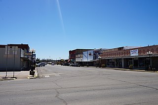
Hugo is a city in and the county seat of Choctaw County, Oklahoma, United States. It is located in southeastern Oklahoma, approximately 9 miles (14 km) north of the Texas state line. As of the 2010 census, the city population was 5,310.
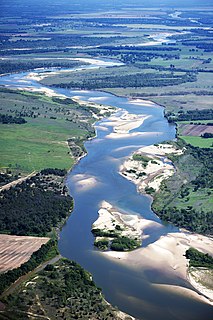
The Red River, or sometimes the Red River of the South, is a major river in the Southern United States. It was named for its reddish water color from passing through red-bed country in its watershed. It is one of several rivers with that name. Although once a tributary of the Mississippi River, the Red River is now a tributary of the Atchafalaya River, a distributary of the Mississippi that flows separately into the Gulf of Mexico. This confluence is connected to the Mississippi River by the Old River Control Structure.
The Arkansas Territory was a territory of the United States that existed from July 4, 1819, to June 15, 1836, when the final extent of Arkansas Territory was admitted to the Union as the State of Arkansas. Arkansas Post was the first territorial capital (1819–1821) and Little Rock was the second (1821–1836).

The Territory of Oklahoma was an organized incorporated territory of the United States that existed from May 2, 1890, until November 16, 1907, when it was joined with the Indian Territory under a new constitution and admitted to the Union as the state of Oklahoma.
The Canadian River is the longest tributary of the Arkansas River in the United States. It is about 906 miles (1,458 km) long, starting in Colorado and traveling through New Mexico, the Texas Panhandle, and Oklahoma. The drainage area is about 47,700 square miles (124,000 km2).
The Unassigned Lands in Oklahoma were in the center of the lands ceded to the United States by the Creek (Muskogee) and Seminole Indians following the Civil War and on which no other tribes had been settled. By 1883 it was bounded by the Cherokee Outlet on the north, several relocated Indian reservations on the east, the Chickasaw lands on the south, and the Cheyenne-Arapaho reserve on the west. The area amounted to 1,887,796.47 acres.
Lighthorse was the name given by the Five Civilized Tribes of the United States to their mounted police force. The Lighthorse were generally organized into companies and assigned to different districts. Perhaps the most famous were the Cherokee Lighthorsemen which had their origins in Georgia. Although the mounted police were disbanded when the Five Civilized Tribes lost their tribal lands in the late 19th century, some tribes still use the Lighthorse name for elements of their police forces.

Eagletown is an unincorporated community and census-designated place in McCurtain County, Oklahoma, United States. The population was 528 at the 2010 census. Located on Mountain Fork River, approximately 6 miles (9.7 km) from the Oklahoma-Arkansas border, it was the first permanent Choctaw settlement in the Indian Territory, who called it osi yamaha ("Eagle"). Eagletown was an important town from 1834 to 1906, and after 1850, served as county seat for the Choctaw Nation's Eagle County. The town name was officially changed to "Eagle Town" in 1850, then changed to the present Eagletown in 1892. When Indian Territory was preparing to unite with Oklahoma Territory to form the new state of Oklahoma in 1906, Eagletown lost its county seat status and became just another unincorporated community in the new McCurtain County.
Boggy Depot is a ghost town and Oklahoma State Park that was formerly a significant city in the Indian Territory. It grew as a vibrant and thriving town in present-day Atoka County, Oklahoma, United States, and became a major trading center on the Texas Road and the Butterfield Overland Mail route between Missouri and San Francisco. After the Civil War, when the MKT Railroad came through the area, it bypassed Boggy Depot and the town began a steady decline. It was soon replaced by Atoka as the chief city in the area. By the early 20th century, all that remained of the community was a sort of ghost town.

Choctaw Country is the Oklahoma Department of Tourism and Recreation's official tourism designation for Southeastern Oklahoma. The name was previously Kiamichi Country until changed in honor of the Choctaw Nation headquartered there. The current definition of Choctaw Country includes ten counties, being Coal, Atoka, Bryan, Choctaw, McCurtain, Pushmataha, Le Flore, Latimer, Haskell, and Pittsburg counties. The department created the term as one of six designated travel regions within the state. However, other definitions of Southeastern Oklahoma may include additional counties.
Miller Court House was the first post office located in what is now Oklahoma, United States. It was located in what was then Miller County, Arkansas Territory. The post office opened September 5, 1824, and was closed December 28, 1839. Miller Court House was the county seat of old Miller County. On January 20, 1825, the land was ceded by treaty to the Choctaw Nation, and non-Native Americans were forced to leave. Before leaving in November 1828, they burned the courthouse and records in protest. The exact site is unknown, but it was in what is now McCurtain County, Oklahoma.
Island Bayou is a 46.0-mile-long (74.0 km) tributary of the Red River in Oklahoma.

The Treaty of Doak's Stand was signed on October 18, 1820 between the United States and the Choctaw Indian tribe. Based on the terms of the accord, the Choctaw agreed to give up approximately one-half of their remaining Choctaw homeland. In October 1820, Andrew Jackson and Thomas Hinds were sent as commissioners who represented the United States to negotiate a treaty to surrender a large portion of Choctaw country in Mississippi. They met with tribal representatives at Doak's Stand on the Natchez Trace. They met with the chiefs Pushmataha, Mushulatubbee, and Apuckshunubbee, who represented the three major regional divisions of the Choctaw. Chiefs of the towns and other prominent men accompanied them, such as Colonel Silas Dinsmoor.
Martin Luther Thompson was a Texas Choctaw leader and rancher who along with his relatives, William Clyde Thompson (1839–1912), Robert E. Lee Thompson (1872–1959) and John Thurston Thompson (1864–1907), led several families of Choctaws from the Mount Tabor Indian Community in Rusk County, Texas to Pickens County, Chickasaw Nation, I.T.
Towson County was a political subdivision of the Choctaw Nation of Indian Territory, prior to Oklahoma being admitted as a state. The county formed part of the Nation's Apukshunnubbee a District, or Second District, one of three administrative super-regions.