Minden, Louisiana | |
---|---|
City of Minden | |
Coordinates: 32°37′0″N93°17′0″W / 32.61667°N 93.28333°W | |
Country | United States |
States | Louisiana |
Founded | 1836 |
Government | |
• Mayor | Nick Cox |
Area | |
• Total | 15.21 sq mi (39.39 km2) |
• Land | 15.04 sq mi (38.95 km2) |
• Water | 0.17 sq mi (0.44 km2) |
Population (2020) | |
• Total | 11,928 |
• Density | 793.24/sq mi (306.27/km2) |
Time zone | UTC-6 (CST) |
• Summer (DST) | UTC-5 (CDT) |
ZIP code | 71055 |
Area code(s) | 318 |
FIPS code | 22-50885 |
Website | Minden, Louisiana |
Minden is a city and parish seat in Webster Parish, Louisiana, United States. It is located twenty-eight miles east of Shreveport. As of the 2020 census, the city had a total population of 11,928. The Main Street district of Minden is recognized as a Louisiana Main Street Community, a Louisiana Cultural Products District, and is sited on the National Register of Historic Places. Minden is the core and principal city of the Minden Micropolitan Statistical Area, consisting of all of Webster Parish, which is included in the Shreveport–Bossier City–Minden CSA.
Minden was established in 1836 by Charles Veeder. Native sons include Gene Austin and Louis Dunbar.
The town's name is derived from the German city of Minden.
The city of Minden was used as a blueprint for the fictional city of Bon Temps, the setting of the Southern Vampire Mysteries series by Charlaine Harris.
During the Civil War, a large Confederate encampment was located inside of Minden. It housed about 15,000 Confederate soldiers. The town served as a supply depot for the Confederate Army. Close to thirty Confederate soldiers who died in the Battles of Mansfield and Pleasant Hill are buried in the Old Minden Cemetery.
In the Great Blizzard of 1899, Minden experienced the coldest temperature ever recorded in Louisiana, when the temperature fell on February 13, 1899 to −16 °F or −26.7 °C. [3]
During the Great Depression, one of the two Minden banks failed and a fire destroyed a major section of the downtown area (1931).
On May 1, 1933, a tornado occurred in the town, destroying 20% of the homes.
According to the United States Census Bureau, the city has a total area of 31.0 km² (12.0 mi²). 30.8 km2 (11.9 mi²) of it is land and 0.2 km2 (0.1 mi²) of it is water. The total area is 0.75% water. [4]
Climate data for Minden, Louisiana (1991–2020 normals, extremes 1893–2021) | |||||||||||||
---|---|---|---|---|---|---|---|---|---|---|---|---|---|
Month | Jan | Feb | Mar | Apr | May | Jun | Jul | Aug | Sep | Oct | Nov | Dec | Year |
Record high °F (°C) | 85 (29) | 92 (33) | 92 (33) | 95 (35) | 99 (37) | 106 (41) | 111 (44) | 112 (44) | 110 (43) | 100 (38) | 94 (34) | 88 (31) | 112 (44) |
Mean maximum °F (°C) | 75.2 (24.0) | 78.3 (25.7) | 83.4 (28.6) | 87.0 (30.6) | 91.2 (32.9) | 95.5 (35.3) | 99.4 (37.4) | 100.4 (38.0) | 96.5 (35.8) | 90.4 (32.4) | 82.0 (27.8) | 76.8 (24.9) | 101.5 (38.6) |
Mean daily maximum °F (°C) | 57.9 (14.4) | 61.9 (16.6) | 69.9 (21.1) | 77.4 (25.2) | 84.3 (29.1) | 90.9 (32.7) | 94.2 (34.6) | 94.7 (34.8) | 89.3 (31.8) | 79.2 (26.2) | 68.1 (20.1) | 59.8 (15.4) | 77.3 (25.2) |
Daily mean °F (°C) | 46.0 (7.8) | 49.5 (9.7) | 57.1 (13.9) | 64.5 (18.1) | 73.0 (22.8) | 80.3 (26.8) | 83.5 (28.6) | 83.3 (28.5) | 77.3 (25.2) | 66.0 (18.9) | 55.4 (13.0) | 48.1 (8.9) | 65.3 (18.5) |
Mean daily minimum °F (°C) | 34.2 (1.2) | 37.2 (2.9) | 44.3 (6.8) | 51.5 (10.8) | 61.7 (16.5) | 69.7 (20.9) | 72.9 (22.7) | 71.9 (22.2) | 65.4 (18.6) | 52.9 (11.6) | 42.7 (5.9) | 36.3 (2.4) | 53.4 (11.9) |
Mean minimum °F (°C) | 19.5 (−6.9) | 24.4 (−4.2) | 28.0 (−2.2) | 36.8 (2.7) | 47.4 (8.6) | 60.8 (16.0) | 66.8 (19.3) | 64.7 (18.2) | 52.7 (11.5) | 37.1 (2.8) | 27.8 (−2.3) | 22.8 (−5.1) | 17.9 (−7.8) |
Record low °F (°C) | 0 (−18) | −16 (−27) | 14 (−10) | 25 (−4) | 34 (1) | 48 (9) | 50 (10) | 52 (11) | 37 (3) | 22 (−6) | 12 (−11) | 2 (−17) | −16 (−27) |
Average precipitation inches (mm) | 5.27 (134) | 5.01 (127) | 5.66 (144) | 6.45 (164) | 4.89 (124) | 4.93 (125) | 3.68 (93) | 3.24 (82) | 3.69 (94) | 4.68 (119) | 4.36 (111) | 5.73 (146) | 57.59 (1,463) |
Average snowfall inches (cm) | 0.1 (0.25) | 0.3 (0.76) | 0.0 (0.0) | 0.0 (0.0) | 0.0 (0.0) | 0.0 (0.0) | 0.0 (0.0) | 0.0 (0.0) | 0.0 (0.0) | 0.0 (0.0) | 0.0 (0.0) | 0.0 (0.0) | 0.4 (1.0) |
Average precipitation days (≥ 0.01 in) | 9.0 | 8.8 | 9.4 | 7.5 | 7.9 | 8.2 | 7.4 | 6.7 | 6.1 | 6.8 | 7.9 | 9.0 | 94.7 |
Average snowy days (≥ 0.1 in) | 0.1 | 0.2 | 0.0 | 0.0 | 0.0 | 0.0 | 0.0 | 0.0 | 0.0 | 0.0 | 0.0 | 0.1 | 0.4 |
Source: NOAA [5] [6] |
Census | Pop. | Note | %± |
---|---|---|---|
1850 | 533 | — | |
1860 | 1,144 | 114.6% | |
1870 | 1,100 | −3.8% | |
1880 | 1,113 | 1.2% | |
1890 | 1,298 | 16.6% | |
1900 | 1,561 | 20.3% | |
1910 | 3,002 | 92.3% | |
1920 | 6,105 | 103.4% | |
1930 | 5,623 | −7.9% | |
1940 | 6,677 | 18.7% | |
1950 | 9,787 | 46.6% | |
1960 | 12,785 | 30.6% | |
1970 | 13,996 | 9.5% | |
1980 | 15,084 | 7.8% | |
1990 | 13,661 | −9.4% | |
2000 | 13,027 | −4.6% | |
2010 | 13,082 | 0.4% | |
2020 | 11,928 | −8.8% | |
U.S. Decennial Census [7] |
Race | Number | Percentage |
---|---|---|
White (non-Hispanic) | 4,966 | 41.63% |
Black or African American (non-Hispanic) | 6,352 | 53.25% |
Native American | 25 | 0.21% |
Asian | 60 | 0.5% |
Pacific Islander | 7 | 0.06% |
Other/Mixed | 334 | 2.8% |
Hispanic or Latino | 184 | 1.54% |
As of the 2020 United States census, there were 11,928 people, 5,189 households, and 3,126 families residing in the city.
Webster Parish is a parish located in the northwestern section of the U.S. state of Louisiana. The seat of the parish is Minden.
Bossier Parish is a parish located in the northwestern part of the U.S. state of Louisiana. At the 2020 census, the population was 128,746.
Bienville is a village in Bienville Parish, Louisiana, United States. The population was 218 at the 2010 census.
Ringgold is a town in the U.S. state of Louisiana, in the western half of Bienville Parish. The town of Ringgold is named for United States Army Major Samuel Ringgold. The population of Ringgold was 1,495 at the 2010 census, and 1,370 at the U.S. Census Bureau's 2019 estimates, down from 1,601 in 2018. The 2020 U.S. census estimates program recorded a population of 1,336, though the census established a population of 1,379. It is the second largest incorporated municipality in Bienville Parish by population.
Benton is a town in, and the parish seat of, Bossier Parish, in the U.S. state of Louisiana. The population was 2,048 in 2020. The town is named for 19th century U.S. Senator Thomas Hart Benton, a Democrat from Missouri and an ally of U.S. President Andrew Jackson.
Bossier City is a city in Bossier Parish in the northwestern region of the state of Louisiana in the United States. It is the second-most populous city in the Shreveport–Bossier City metropolitan statistical area. In 2020, it had a total population of 62,701, up from 61,315 in 2010.
Haughton is a town in Bossier Parish, Louisiana, United States. The population was 4,539 in 2020. It is part of the Shreveport–Bossier City metropolitan statistical area.
Plain Dealing is a town in Bossier Parish, Louisiana, United States. The population was 893 in 2020. It is part of the Shreveport–Bossier City metropolitan statistical area.
Belcher is a village in Caddo Parish, Louisiana, United States. The population was 263 at the 2010 census. It is part of the Shreveport- Bossier city metropolitan statistical area.
Blanchard is the suburban town in, and the second-largest municipality by population of Caddo Parish in the U.S. state of Louisiana. With a population of 3,538 at the 2020 U.S. census, it is part of the Shreveport–Bossier City metropolitan statistical area.
Homer is a town in and the parish seat of Claiborne Parish in northern Louisiana, United States. Named for the Greek poet Homer, the town was laid out around the Courthouse Square in 1850 by Frank Vaughn. The present-day brick courthouse, built in the Greek Revival style of architecture, is one of only four pre-Civil War courthouses in Louisiana still in use. The building, completed in 1860, was accepted by the Claiborne Parish Police Jury on July 20, 1861, at a cost of $12,304.36, and is on the National Register of Historic Places. The other courthouses are in St. Francisville, St. Martinville and Thibodaux.
Ashland is a village in the northernmost portion of Natchitoches Parish, Louisiana, United States. A few residences and a convenience store to the north spill over into neighboring Bienville Parish. The population was 291 at the 2000 census but declined nine percent to 269 in 2010. The median age was 45.7 years. Ashland is part of the Natchitoches Micropolitan Statistical Area.
Cullen is a town just south of Springhill in northern Webster Parish, Louisiana, United States. The population was 1,163 at the 2010 census. It is part of the Minden Micropolitan Statistical Area.
Dubberly is a village in Webster Parish, Louisiana, United States. The population was 290 at the 2000 census. It is part of the Minden Micropolitan Statistical Area.
Heflin is a village in southern Webster Parish, Louisiana, United States. The population was 245 at the 2000 census. It is part of the Minden Micropolitan Statistical Area.
Sarepta is a town in Webster Parish, Louisiana, United States. The population was 891 at the 2010 census. It is part of the Minden Micropolitan Statistical Area.
Shongaloo is a village in Webster Parish, Louisiana, United States.
Springhill is a city in northern Webster Parish, Louisiana, United States. The population was 5,279 at the 2010 census, a decrease of 160 since 2000. Springhill is part of the Minden Micropolitan Statistical Area though it is thirty miles north of Minden, the seat of government of Webster Parish. The Springhill population is 34 percent African American, compared to 25 percent minority in 2000.
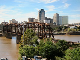
Shreveport is a city in the U.S. state of Louisiana. It is the third-most populous city in Louisiana after New Orleans and Baton Rouge. The bulk of Shreveport is in Caddo Parish, of which it is the parish seat. It extends along the west bank of the Red River into neighboring Bossier Parish. The 2020 census tabulation for the city's population was 187,593, while the Shreveport–Bossier City metropolitan area had a population of 393,406.
Calhoun is an unincorporated community and census-designated place in Ouachita Parish, Louisiana, United States. It is named after Archibald Calhoun, who was an original settler and landowner. Its elevation is 177 feet (54 m), and it is located at 32°30′46″N92°21′31″W. Calhoun is unincorporated and is governed by the parish through a board of commissioners known as the Police Jury. It is a census designated place and at the time of the most recent United States Census Survey, the population was 1,965.