
The Loyalsock Trail (LT) is a 59.2 mi (95.3 km) linear hiking trail in Lycoming and Sullivan counties in north-central Pennsylvania. It is roughly parallel to Loyalsock Creek and traverses rugged lands mostly in Loyalsock State Forest. The trail is maintained by the Alpine Club of Williamsport and has been known for its distinctive blazes, made from the tops of tin cans and painted a distinctive color with "LT" in the center. Many of these are still present but some have given way to painted yellow blazes with a red stripe in the center. The Loyalsock Trail is also the main artery in a network of associated trails called "Red X" trails for alternate routes, plus blue-blazed spur trails to nearby roads and white-blazed side trails to various points of interest.

The Thunder Swamp Trail is a 31.7-mile (51.0 km) hiking trail system in Delaware State Forest in the Pocono Mountains region of northeastern Pennsylvania. The 18.3 mile main loop includes a junction with the one-way northeast spur that leads to Stillwater Natural Area; the spur adds 13.4 miles if hiked in both directions.

The Pinchot Trail System is a 22.2-mile (35.7 km) hiking trail in Pinchot State Forest in the Pocono Mountains region of northeastern Pennsylvania. The trail is marked with orange blazes as a designated Pennsylvania State Forest hiking trail. While it is a single loop trail, the word "System" is in its name because it was formed from several previously existing trails with distinct names, and many of those old names are still visible on trail signs for their historical interest.

The Quehanna Trail is a 73.2-mile (117.8 km) hiking trail in north-central Pennsylvania, forming a loop through Moshannon State Forest and Elk State Forest. For about 34 miles, the trail traverses Quehanna Wild Area, and its main trailhead is at Parker Dam State Park. It also passes through two State Game Lands. There are also three cross-connector trails allowing shorter loop hikes of various lengths. A spur trail leads to the village of Wyside where the hiker can, via some relatively brief road walking, reach the Donut Hole Trail and Bucktail Path. The Quehanna Trail is known for visiting numerous vistas and a wide variety of landscapes, including open meadows that are relatively rare for this region of Pennsylvania, plus steep stream hollows, high plateau-tops, and several different forest ecosystems.

The Old Loggers Path is a 27.8 mi (44.7 km) hiking trail in north-central Pennsylvania, forming a loop through Loyalsock State Forest. The most commonly used trailhead is at the ghost town of Masten. The trail makes use of abandoned logging railroad grades originating in the late 1800s, and some roads originally built by the Civilian Conservation Corps in the 1930s. The trail is known for numerous vistas, rock formations, and scenic streams, and for the remnants of past industrial infrastructure reclaimed by the forest.

The West Rim Trail is a 30.5 mi (49.1 km) linear hiking trail in Lycoming and Tioga Counties in north central Pennsylvania. The trail mostly follows the edge of Pine Creek Gorge, also known as the Grand Canyon of Pennsylvania, which is up to 1,000 feet (300 m) deep and about 2,000 feet (610 m) wide from rim to rim in the area traversed by the trail. The trail is entirely within Tioga State Forest and is known for its large number of vistas overlooking the gorge, which is a National Natural Landmark and one of the deepest gorges in the eastern United States.

The Susquehannock Trail System (STS) is an 83.4-mile (134.2 km) loop hiking trail in Susquehannock State Forest in Potter County in north-central Pennsylvania, United States. The trail walks through two state parks and passes near three more state parks. It also traverses Hammersley Wild Area, the largest area in Pennsylvania without a road. The loop is supplemented by two cross-connector trails, several short access trails, a shared path with the Donut Hole Trail, and two connectors to the Black Forest Trail. The STS is the oldest backpacking trail in Pennsylvania, and has been noted for its solitude while traversing remote areas with few signs of civilization. The STS also includes several overnight shelters.

The Black Forest Trail is a 43.0-mile (69.2 km) hiking trail in north-central Pennsylvania, forming a loop through portions of Tiadaghton State Forest and routed through Pine Creek Gorge and areas of the Allegheny Plateau above the gorge. Most of the trail is in Lycoming County, with about five miles in Potter County and a very brief segment in Clinton County. The trail was named after the region's original forest landscape, which reminded immigrant loggers of the Schwarzwald region of Germany.

The John P. Saylor Trail is a 17.5-mile (28.2 km) hiking trail system in southwestern Pennsylvania, consisting of two loops with a short cross-connector trail, through Gallitzin State Forest in Somerset County. The trail is named after Congressman John P. Saylor, who sponsored the National Scenic Trails Act while supporting national wilderness preservation. The main loop, which can be reached from the trailhead, is 12.0 miles around. The south loop, which cannot be reached directly by car, can be combined with the main loop and the short cross-connector, for a "figure-8" hike of 17.5 miles.

The Tanbark Trail is an 8.8-mile (14.2 km) hiking trail in Allegheny National Forest in northwestern Pennsylvania, which is usually described as a spur of the North Country Trail. It is known for visiting some of the least disturbed areas of the National Forest, as well as several large rock formations and scenic glens along small streams.

The Morrison Trail is a hiking trail system in Allegheny National Forest in northwestern Pennsylvania, consisting of 12 linear miles of trails. The system includes an entrance trail from Pennsylvania Route 59 that leads to a long loop trail, which in turn includes a cross-connector trail, enabling several different loops of various lengths.
The Fred Woods Trail is a 4.5-mile (7.2 km) loop hiking trail in Elk State Forest in north-central Pennsylvania, United States. The trail visits three significant vistas over the valley of the Bennett Branch of Sinnemahoning Creek, and several large rock formations. The trail is known for requiring almost no climbing to reach its vistas on top of the Allegheny Plateau.
The Gerard Hiking Trail is an approximately 36-mile (58 km) hiking trail in Oil Creek State Park in northwestern Pennsylvania, forming a long and narrow loop on both sides of Oil Creek. Several cross-connector trails enable shorter loops of various lengths. The trail is known for numerous vistas over Oil Creek and the state park, many small waterfalls on side streams, and historic artifacts associated with early American oil exploration led by Edwin Drake, who struck oil in the area in 1859.

The Allegheny Front Trail is a 41.9-mile (67.4 km) hiking trail in central Pennsylvania, forming a loop through Moshannon State Forest and roughly encircling Black Moshannon State Park. It is known for visiting several vistas off the Allegheny Front, for walking along "Red" Moshannon Creek for a significant distance, and for visiting many different ecosystems ranging from wetlands to forested hollows to high meadows. The trail crosses Pennsylvania Route 504 twice and can also be reached from two side trails that originate in the state park.

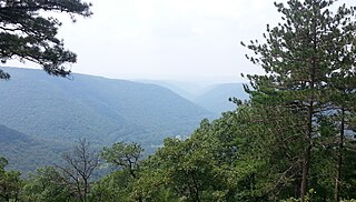
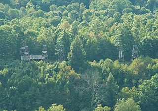
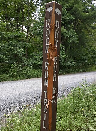
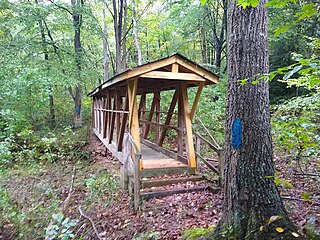
The Rock Run Trails System (RRTS) is a 12.2-mile (19.6 km) cross-country skiing and hiking trail in central Pennsylvania, consisting of an entrance trail and loop in Moshannon State Forest. It follows several former logging railroad grades, some of significant historical interest. It shares part of its route with the Allegheny Front Trail.
The T-Squared Trail is a 5.7-mile (9.2 km) linear hiking trail in north-central Pennsylvania, through portions of Sproul State Forest and Tiadaghton State Forest. For most hikers, the T-Squared Trail serves as a connection between two long-distance backpacking routes: the Donut Hole Trail and the Black Forest Trail.

The Chuck Keiper Trail is a hiking trail system in north-central Pennsylvania, consisting of 50.6 linear miles of trails, forming a loop with a cross-connector through Sproul State Forest. Most of the system is in Clinton County, with a portion of the southwestern segment of the loop in Centre County. The trail is known for traversing one of the least populated regions of Pennsylvania, combining high areas on top of the Allegheny Plateau with many rugged climbs into and out of stream hollows; the trail also visits two state natural areas and two state wild areas. It is often cited as one of Pennsylvania's most remote and difficult backpacking trails.

The Hickory Creek Trail is an 11.6-mile (18.7 km) hiking trail in Allegheny National Forest in northwestern Pennsylvania. The trail traverses remote areas of the Hickory Creek Wilderness; its route includes a large loop and a short entrance trail that must be completed in both directions.

The Tracy Ridge Hiking Trail System is a 33.7-mile (54.2 km) system of interconnected hiking trails in Allegheny National Forest in northwestern Pennsylvania. The system was designed to visit the most remote areas of the Tracy Ridge portion of Allegheny National Recreation Area.
The Terrace Mountain Trail is a 25.9-mile (41.7 km) linear hiking trail in south-central Pennsylvania, United States, which is mostly parallel to the shore of Raystown Lake. The trail is open to both hiking and mountain biking. The trail is maintained by the US Army Corps of Engineers as part of its management of the Raystown Lake complex. After the development of Raystown Dam and the artificial lake in 1973, the western flank of Terrace Mountain alongside the lake became part of a protected area mostly owned by the federal government, interspersed with some tracts of Pennsylvania's Rothrock State Forest and Trough Creek State Park. The Terrace Mountain Trail visits all these areas.
