Mitchell was built as a railroad town in the mid-19th century. At this location in Lawrence County, the Chicago, Indianapolis and Louisville Railroad, better known by the shorter name of "the Monon", was built as a north–south line from New Albany to Chicago, passing through the area which became Mitchell in 1853. In 1857, the east–west Ohio and Mississippi Railway (later part of the Baltimore and Ohio Railroad) was completed, as part of a link between Cincinnati and St. Louis.
The town was incorporated in 1864,[4] becoming a city in 1907. Mitchell hosted a number of manufacturers, including (in 1919) the wagon, truck and bus body enterprises of Ralph H. Carpenter which became known as the Carpenter Body Company. School bus body production continued until 1995.[citation needed]
In 1851, the Mitchell area was the birthplace of outlaw and train robberSam Bass (1851–1878). He was orphaned at age 13, but was apparently engaged in lawful activities until 1877, when he became an icon of the "wildness" of the American Old West as he robbed banks, stagecoaches and railroad trains before being fatally wounded by Texas Rangers the following year. Despite Bass' short-lived criminal career, he is remembered as part of a robbery of gold on September 18, 1877, which remains the largest robbery in Union Pacific Railroad's history.
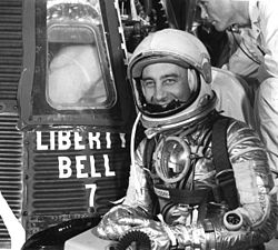
U.S. astronaut Gus Grissom, native of Mitchell, Indiana, in front of the Liberty Bell 7 capsule, in which he became the second American to fly in outer spaceThe Gus Grissom Memorial in Mitchell, Indiana
Spring Mill State Park is located just east of Mitchell. It includes a memorial to Grissom as well as several caves and a pioneer village. The buildings in the village are original structures from the former mill town that was located here, recreations of buildings in the town, and other pioneer-era buildings that were moved to the park.
The Monon became part of the Louisville and Nashville Railroad. Both it, and the former B&O are now part of CSX Transportation's rail network. In modern times, Mitchell is also served by the Union Pacific system.
In the late 20th century, Mitchell's downtown area was defined as a historic district that was listed on the National Register of Historic Places. The town developed an Urban Enterprise Zone, and industrial park, and at the end of the century, was working to attract new businesses and industry while also capitalizing on its heritage through antique shops and tourism.
According to the 2010 census, Mitchell has a total area of 3.285 square miles (8.51km2), of which 3.28 square miles (8.50km2) (or 99.85%) is land and 0.005 square miles (0.01km2) (or 0.15%) is water.[7]
As of the census[9] of 2010, there were 4,350 people, 1,786 households, and 1,145 families living in the city. The population density was 1,326.2 inhabitants per square mile (512.0/km2). There were 2,014 housing units at an average density of 614.0 per square mile (237.1/km2). The racial makeup of the city was 97.6% White, 0.4% African American, 0.2% Native American, 0.3% Asian, 0.1% Pacific Islander, 0.7% from other races, and 0.8% from two or more races. Hispanic or Latino of any race were 1.4% of the population.
There were 1,786 households, of which 33.2% had children under the age of 18 living with them, 43.8% were married couples living together, 15.0% had a female householder with no husband present, 5.3% had a male householder with no wife present, and 35.9% were non-families. 31.9% of all households were made up of individuals, and 15.5% had someone living alone who was 65 years of age or older. The average household size was 2.38 and the average family size was 2.96.
The median age in the city was 39.2 years. 24.9% of residents were under the age of 18; 8.3% were between the ages of 18 and 24; 24.7% were from 25 to 44; 25% were from 45 to 64; and 17.1% were 65 years of age or older. The gender makeup of the city was 46.5% male and 53.5% female.
2000 census
As of the census[3] of 2000, there were 4,567 people, 1,884 households, and 1,235 families living in the city. The population density was 1,345.6 inhabitants per square mile (519.5/km2). There were 2,118 housing units at an average density of 624.1 per square mile (241.0/km2). The racial makeup of the city was 98.31% White, 0.28% African American, 0.11% Native American, 0.09% Asian, 0.02% Pacific Islander, 0.13% from other races, and 1.05% from two or more races. Hispanic or Latino of any race were 0.53% of the population.
There were 1,884 households, out of which 32.6% had children under the age of 18 living with them, 46.5% were married couples living together, 14.9% had a female householder with no husband present, and 34.4% were non-families. 31.2% of all households were made up of individuals, and 14.8% had someone living alone who was 65 years of age or older. The average household size was 2.36 and the average family size was 2.93.
In the city the population was spread out, with 26.0% under the age of 18, 7.9% from 18 to 24, 27.1% from 25 to 44, 22.9% from 45 to 64, and 16.2% who were 65 years of age or older. The median age was 37 years. For every 100 females, there were 85.0 males. For every 100 females age 18 and over, there were 79.4 males.
The median income for a household in the city was $28,559, and the median income for a family was $33,415. Males had a median income of $28,160 versus $18,194 for females. The per capita income for the city was $13,894. About 14.0% of families and 16.9% of the population were below the poverty line, including 20.9% of those under age 18 and 16.7% of those age 65 or over.
Economy
Heidelberg Materials's $600million cement plant, the second-largest in the U.S., was completed in 2023.[10] In March 2024, the Biden administration's Department of Energy (DOE) awarded the company a grant of up to $500million to develop a system for capturing and underground storing of carbon produced by its cement production. The plant's project was one of 33 in 20 states selected for a major DOE carbon reduction project.[11] In May 2025, the Trump administration cancelled the grant as part of its efforts to end projects intended to slow global warming. The demonstration project would have brought 1,000 construction jobs and around three dozen permanent positions to the town.[12]
Education
The town has a lending library, the Mitchell Community Public Library.[13]
This page is based on this Wikipedia article Text is available under the CC BY-SA 4.0 license; additional terms may apply. Images, videos and audio are available under their respective licenses.