Webster's Dictionary is any of the English language dictionaries edited in the early 19th century by Noah Webster (1758–1843), an American lexicographer, as well as numerous related or unrelated dictionaries that have adopted the Webster's name in his honor. "Webster's" has since become a genericized trademark in the United States for English dictionaries, and is widely used in dictionary titles.

Merriam-Webster, Incorporated is an American company that publishes reference books and is mostly known for its dictionaries. It is the oldest dictionary publisher in the United States.

Korea(n) Bay, sometimes West Korea(n) Bay, is a bight and the northern extension of the Yellow Sea, between the southeastern coastline of China's Liaoning Province and the western coastline of North Korea's North Pyongan, South Pyongan and South Hwanghae provinces. It is separated from the Bohai Sea by the Liaodong Peninsula, with Dalian's Lüshunkou District marking its western end, and westernmost tip of North Korea's Ryongyon County as its eastern end.
Kikori is a small town in the Gulf Province of Papua New Guinea.
Merriam-Webster's Geographical Dictionary is a gazetteer by the publisher Merriam-Webster. The latest edition was released in 2001, edited by Daniel J. Hopkins and contained over 54,000 entries. The first edition was published in 1949 and the second edition in 1972.
Lombardsijde, also Lombartzyde, is a district in the Belgian municipality of Middelkerke in West Flanders province, in northwestern Belgium near Nieuwpoort.

Nansen Sound is an uninhabited strait in Qikiqtaaluk, Nunavut, Canada. It lies between western Grant Land on Ellesmere Island and Axel Heiberg Island. Tanquary Fiord or Greely Fiord enters the sound from the east.
Massacre Bay is an inlet on the southeast coast of the island of Attu in the Aleutian Islands in Alaska. Massacre Bay was among the landing sites of United States Army troops in the Battle of Attu in May 1943, which led to the recapture of the island from the Japanese during World War II.

Holtz Bay is an inlet on the northeast coast of the island of Attu in the Aleutian Islands in Alaska.
Sarana Pass is a pass in the mountains of northeastern Attu Island in the Aleutian Islands in Alaska.

Chichagof Harbor is an inlet on the northeast coast of the island of Attu in the Aleutian Islands in Alaska. It is named after Russian Admiral and polar explorer Vasily Chichagov. It was the location of an Aleut village served by an American pastor and his wife. It was also where some heavy fighting took place during the recapture of the island from the Japanese during the Battle of Attu in World War II and afterwards was the site of Battery B 42nd Coast Artillery Battalion.
The Pescara Pass is a mountain pass through the Abruzzi Apennines along the Pescara River. It lies south of Gran Sasso d'Italia, Italy.

The Giovi Pass is a pass in Italy in the northwestern Ligurian Apennines north of Genoa.
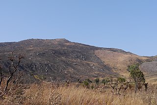
Mount Moco, at 2,620 metres (8,600 ft), is the highest mountain in Angola. It is located in Huambo Province in the western part of the country, 70 kilometres (43 mi) west of the city of Huambo. Mount Moco was named one of Angola's "seven wonders" in 2014. The mountain is a destination for birdwatchers, hikers, and people participating in rappelling and paragliding.
Dranova Island is an island in eastern Romania, in the southern part of the Danube Delta. It has an area of 217.6 km2 (84.0 sq mi).

Lake Lawtonka is a lake in Comanche County in the state of Oklahoma in the United States. The lake is 2 square miles (5 km2) in area. It is formed by a dam 60 feet (18 m) and 375 feet (114 m) long across Medicine Creek.
Mount Leonard Murray is a mountain in Papua New Guinea in central New Guinea. It is north-west of Kikori and has an elevation of 2,380 metres (7,810 ft).

Cape Charles is a headland, or cape, in Northampton County, Virginia. Located at the southern tip of Northampton County, it forms the southern tip of the Delmarva Peninsula and the northern side of the entrance to the Chesapeake Bay. Cape Charles was named in honor of Charles I of England, the second son of King James I and his eventual successor to the thrones of England, Scotland, and Ireland.
Timbalier Bay is a bay in southeastern Louisiana in the United States.
Oyster Bay, also known as Oyster Bay Harbor, is an inlet of Long Island Sound on the north shore of Long Island in New York in the United States.

