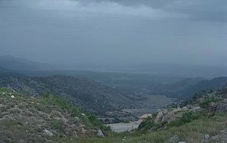
Waziristan is a mountainous region covering the North Waziristan and South Waziristan districts of the Pakistani province of Khyber Pakhtunkhwa. Waziristan covers around 11,585 square kilometres (4,500 sq mi) and is mainly populated by the Wazir Pashtun tribe, who speak the Waziri dialect of the Pashto language.

The Shinwari are an ethnic Pashtun tribe of Afghanistan. Among the greatest poets of the Pashto language in the 20th century was the late Ameer Hamza Shinwari, also known as "Hamza Baba".
The Mohmand or Momand is a prominent tribe of Pashtun people.

The North-West Frontier was a region of the British Indian Empire. It remains the western frontier of present-day Pakistan, extending from the Pamir Knot in the north to the Koh-i-Malik Siah in the west, and separating the modern Pakistani frontier regions of North-West Frontier Province, Federally Administered Tribal Areas and Balochistan from neighbouring Afghanistan in the west. The borderline between is officially known as the Durand Line and divides Pashtun inhabitants of these provinces from Pashtuns in eastern Afghanistan.
A jirga is an assembly of leaders that makes decisions by consensus according to Pashtunwali, the Pashtun social code. It is conducted in order to settle disputes among the Pashtuns, but also by members of other ethnic groups who are influenced by them in present-day Afghanistan and Pakistan.

Parachinar is a town and the capital of the Kurram District in the province of Khyber Pakhtunkhwa, Pakistan.

South Waziristan District was a district in the Dera Ismail Khan Division of the Khyber Pakhtunkhwa province of Pakistan, before splitting into the Lower South Waziristan District and the Upper South Waziristan District on 13 April 2022. It covers around 11,585 km2 (4,473 mi2). Waziristan is located in the southwest of Khyber Pakhtunkhwa. It is situated between two rivers, the Tochi River to the north and the Gomal River to the south. The region was an independent tribal territory from 1893, separated from both Afghanistan and the British-ruled empire in the subcontinent. Raiding the tribal areas was a constant problem for the British, requiring frequent punitive expeditions between 1860 and 1945. Troops of the British Raj coined a name for this region "Hell's Door Knocker" in recognition of the fearsome reputation of the local fighters and inhospitable terrain. The district headquarter of the South Waziristan district is Wanna. South Waziristan is divided into three administrative subdivisions of Ladha, Sarwakai, and Wanna. These three subdivisions are further divided into eight Tehsils: Ladha, Makin, Sararogha, Sarwakai, Tiarza, Wanna, Barmal, and Toi Khula.
Haji Mirzali Khan Wazir, commonly known as the Faqir of Ipi, was a tribal chief and adversary to the British Raj from North Waziristan in what is now Khyber Pakhtunkhwa, Pakistan.

Kurram District is a district in the Kohat Division of the Khyber Pakhtunkhwa province of Pakistan. The name Kurram comes from the river Kwarma in Pashto which itself derives from the Sanskrit word Krumuḥ.

The Frontier Crimes Regulations (FCR) were a special set of laws of British India, and which were applicable to the Tribal Areas. They were enacted by the British Empire in the nineteenth century and remained in effect in Pakistan until 2018. They were extended to the Gilgit Agency in Jammu and Kashmir in 1901 and to Baltistan in 1947, remaining in effect till the 1970s.

Goshta District is located in the northeast of Nangarhar Province, Afghanistan and borders Durand Line between Afghanistan and Pakistan. The district's population is Pashtun and was estimated at 160,000 in 2002, of whom 30,000 were children under 12. The district is within the heartland of the Mohmand tribe of Pashtuns. The district centre is the village of Goshta, on the Kabul River.
The First Mohmand campaign was a British military campaign against the Mohmand from 1897 to 1898.

The Mullagori or Mulagori or Malagori is a Pashtun tribe present in Khyber District, tribal areas in Khyber Pakhtunkhwa, Pakistan. Historically, they are one of the smallest tribes of ethnic Pashtuns. They are considered as a sub-tribe of Momand Pashtun Ghoryakhel confederacy.

The insurgency in Khyber Pakhtunkhwa, also known as the War in North-West Pakistan or Pakistan's war on terror, is an ongoing armed conflict involving Pakistan and Islamist militant groups such as the Tehrik-i-Taliban Pakistan (TTP), Jundallah, Lashkar-e-Islam (LeI), TNSM, al-Qaeda, and their Central Asian allies such as the ISIL–Khorasan (ISIL), Islamic Movement of Uzbekistan, East Turkistan Movement, Emirate of Caucasus, and elements of organized crime. Formerly a war, it is now a low-level insurgency as of 2017.

The Khyber Pass is a mountain pass in the Khyber Pakhtunkhwa province of Pakistan, on the border with the Nangarhar Province of Afghanistan. It connects the town of Landi Kotal to the Valley of Peshawar at Jamrud by traversing part of the White Mountains. Since it was part of the ancient Silk Road, it has been a vital trade route between Central Asia and the Indian subcontinent and a strategic military choke point for various states that controlled it. The Khyber Pass is considered one of the most famous mountain passes in the world.
The Halimzai are the largest sub-tribe or clan of the Mohmand Pashtun tribe.
The Ambela campaign of 1863 was one of many expeditions in the border area between the Emirate of Afghanistan and the Punjab Province of British India against the Hindustani Fanatics at Malka, a colony of malcontents or bigoted Muslims from Hindustan.

The Federally Administered Tribal Areas, commonly known as FATA, was a semi-autonomous tribal region in north-western Pakistan that existed from 1947 until being merged with the neighbouring province of Khyber Pakhtunkhwa in 2018 through the Twenty-fifth amendment to the constitution of Pakistan. It consisted of seven tribal agencies (districts) and six frontier regions, and were directly governed by the federal government through a special set of laws called the Frontier Crimes Regulations.
On 9 July 2010, a suicide bombing occurred in a market in Yakaghund, Mohmand Agency, in the Federally Administered Tribal Areas of Pakistan. At least 104 people were killed while more than 120 people were wounded. This was the last of a streak of attacks that was the record most major terrorist attacks in a row in the Pakistan war on terrorism, with least 7 in a row, much more than the previous record of 2 which happened only 2 times; marking an escalating of the War on Terrorism in Pakistan.

In 1917, the British Empire launched a successful punitive expedition against the Mahsud.


