Monte Cristo, Washington

Last updated

Monte Cristo
Ghost Town
Monte Cristo townsite looking northeast 2014-05-31.jpg
Townsite in 2014
USA Washington location map.svg
Red pog.svg
Monte Cristo
Usa edcp location map.svg
Red pog.svg
Monte Cristo
Coordinates: 47°59′8″N121°23′38″W / 47.98556°N 121.39389°W / 47.98556; -121.39389 Coordinates: 47°59′8″N121°23′38″W / 47.98556°N 121.39389°W / 47.98556; -121.39389
CountryUnited States
State Washington
County Snohomish
Elevation
[1]
2,762 ft (842 m)

Monte Cristo is a ghost town northwest of Monte Cristo Peak, in eastern Snohomish County in western Washington. The town was active as a mining area for gold and silver from 1889 to 1907, and later became a resort town that operated until 1983.

Contents

Location

Monte Cristo is located at the headwaters of the South Fork Sauk River in eastern Snohomish County. It lies in the valley between Silvertip Peak and Cadet Peak. The town is connected via a trail to the Mountain Loop Highway, which continues west to Granite Falls and north to Darrington.

The Monte Cristo Peak, named for the town, is located to the southeast.

History

Prospecting in the region began in the Skykomish River drainage with the Old Cady Trail used for access. In 1882 Elisha Hubbard improved the trail up the North Fork Skykomish, from Index to Galena, then north up the tributary Silver Creek. A boom shortly followed at Mineral City. The mineral belt was traced in various directions, including north over the divide between the Skykomish and Sauk River drainages. In the early summer of 1889 Joseph Pearsall saw glittering deposits and traced them north to Seventysix Gulch and the area that became Monte Cristo. A frenzy of claim staking quickly followed. In 1890 many miners hiked to Monte Cristo from the south by way of Index, Galena, and Mineral City, crossing the divide at first via Wilmans Pass and later via Poodle Dog Pass. In the fall of 1891 a narrow wagon road called the Wilmans or Pioneer Trail was completed from Sauk City on the Skagit River to Monte Cristo, allowing access from the north. A key stop on this road was the trading post at Orient, Washington, at the North and South forks of the Sauk River. Today this area is known as Bedal. In the summer of 1891 it was discovered that Monte Cristo could be accessed via the South Fork Stillaguamish River. A surveyor named M.Q. Barlow blazed a route from Silverton to Monte Cristo. Mining interests Thomas Ewing and George W. Grayson, then miner Edward Blewett, Judge Hiram G. Bond of Denver and New York City, and Seattle publisher Leigh S. J. Hunt, funded further work and soon a wagon road was built over Barlow Pass to join the Sauk wagon road. Later a railroad would be built over the same route. [2]

Monte Cristo was the first live mining camp on the west slopes of the Cascade Range. There were 13 mines and 40 claims by 1891. By 1893 there were 211 mining claims. The boom required money from the eastern United States to continue to grow. [2] In 1891 John D. Rockefeller became interested in Monte Cristo. His syndicate, Colby and Hoyt, took over the primary mines, including the Pride and Mystery mines. The Wilmans brothers were paid $470,000. [2] Rockefeller's companies acquired a controlling two-thirds interest in the best properties. [3] [4] Frederick Trump, grandfather of former U.S. President Donald Trump, was also active in the town; he operated a boom-town hotel and alleged brothel. [5] [6]

United Concentration Company's plant, 1894 United Concentration Company's plant, Monte Cristo, Washington, 1894.jpg
United Concentration Company's plant, 1894

During the 1890s hopes ran high at Monte Cristo. It was widely believed that the area would become the greatest lead-silver district in the Western Hemisphere. [2] Elaborate cable-bucket aerial tramways were built over Mystery Ridge for hauling ore to the town site, carrying as much as 230 tons every day. A five-level concentrator was completed in 1894 at the Monte Cristo townsite. Ore was shipped out via the newly completed railway, 42 miles long from Monte Cristo to Hartford. The boom peaked in 1894, at which time the town's population was well over 1,000. In 1895 there were 125 men employed in the mines with a monthly payroll of $10,500. Employment rose to 200 in 1896. Mining activity indirectly supported about 600 people. [2]

The year 1896 was prosperous but in November major flooding damaged or destroyed railroad tunnels and track. Mining output reached record levels in 1897 but again intense autumn floods devastated the region's infrastructure, the repair of which cut deeply into mining profits. Other problems such as metallic impurities at the Monte Cristo concentrator and the Everett smelter led to the boom collapsing. By 1900 most of the Monte Cristo miners had left for the new mining booms of the Klondike. [2]

Traveling to Monte Cristo in 1916 Travel to Monte Cristo, Washington 1916.jpg
Traveling to Monte Cristo in 1916

Miners and geologists had made mistakes in judging the potential of Monte Cristo's mineral wealth. There were rich surface deposits but they did not continue far into the ground. Mining below about 500 feet turned out to be seldom worth the effort. [2] Mining operations ceased in 1907, probably related to the Panic of 1907. The town survived as a tourist destination for several more decades, but the county road was flooded out in December 1980, and the only remaining business in town, a lodge, burned down in 1983. [7] That same year, a nonprofit group called Monte Cristo Preservation Association stepped in to save and restore the historical site. [8]

Very few original structures are still standing, but the four-mile-long road (as noted in driving directions) [9] into town remains popular with hikers and mountain bikers. The road is impassable to vehicles as the shore on either side of the bridge washed out several years ago. The bridge remained standing, however hikers and mountain bikers now either have to ford the river or cross over fallen trees in order to continue onto the old town-site from the Barlow Pass entry.

Extensive plans for removing pollution from mine tailings have been written, and include removal and/or containment of pollution in remote mine sites in the nearby Glacier Basin. A new access road is part of the plans for the cleanup. [10] Cleanup of arsenic and other toxins left behind began in September 2012. [8]

Mines that are not caved in are: Boston American Mine, Justice Mine, Mystery Mine, and New Discovery Tunnel.

Related Research Articles

Darrington, Washington Town in Washington, United States

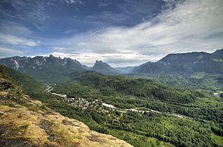
Darrington is a town in Snohomish County, Washington, United States. It is located in a North Cascades mountain valley formed by the Sauk and North Fork Stillaguamish rivers. Darrington is connected to nearby areas by State Route 530, which runs along the two rivers towards the city of Arlington, located 30 miles (48 km) to the west, and Rockport. It had a population of 1,347 at the 2010 census.

Granite Falls, Washington City in Washington, United States

Granite Falls is a city in Snohomish County, Washington, United States. It is located between the Pilchuck and Stillaguamish rivers in the western foothills of the Cascade Range, northeast of Lake Stevens and Marysville. The city is named for a waterfall north of downtown on the Stillagumish River, also accessible via the Mountain Loop Highway. It had a population of 3,364 at the 2010 census.

Index, Washington Town in Washington, United States

Index is a town in Snohomish County, Washington, United States. The population was 178 at the 2010 census.

Sultan, Washington City in Washington, United States

Sultan is a city in Snohomish County, Washington, United States. It is located approximately 23 miles (37 km) east of Everett at the confluence of the Skykomish River and the Sultan River, a minor tributary. The city had a population of 4,651 at the 2010 census.

Sauk River (Washington) River in Washington

The Sauk River is a tributary of the Skagit River, approximately 45 miles (72 km) long, in northwestern Washington in the United States. It drains an area of the high Cascade Range in the watershed of Puget Sound north of Seattle. The river is a popular destination for fly fishing. It is a National Wild and Scenic River.

Skykomish River River in northwest Washington, United States

The Skykomish River is a 29-mile (47 km) long river in the U.S. state of Washington which drains the west side of the Cascade Mountains in the southeast section of Snohomish County and the northeast corner of King County. The river starts with the confluence of the North Fork Skykomish River and South Fork Skykomish River approximately one mile west of Index, then flowing northwesterly towards Puget Sound. It is joined by the Sultan River and the Wallace River at Sultan. It then meets the Snoqualmie River to form the Snohomish River at Monroe. The Snohomish River continues along the river valley eventually dumping into Port Gardner Bay on Possession Sound.

The Mountain Loop Highway is a highway in the U.S. state of Washington. It traverses the western section of the Cascade Range within Snohomish County. The name suggests it forms a full loop, but it only is a small portion of a loop, which is completed using State Routes 92, 9, and 530. Part of the highway is also a designated and signed Forest Highway, and is known as Forest Route 20.

Barlow Pass (Washington)

Barlow Pass is a mountain pass on the west side of the Cascades in Washington on the Mountain Loop Highway between Silverton and Darrington. It is a popular trail head for access to the old mining town of Monte Cristo and has a branch off to hike up to Gothic Basin, which is about a mile in.

Robe Canyon Historic Trail

The Robe Canyon Historic Trail is a county park and hiking trail located east of Granite Falls, Washington. The park, maintained by Snohomish County, encompasses 970 acres (3.9 km2) of wilderness area along the Stillaguamish River and features railroad tunnels, river beaches, and hiking trails.

Sultan River Tributary of the Skykomish River, northwest Washington, United States

The Sultan River is a river in Snohomish County in the U.S. state of Washington. It is a tributary of the Skykomish River, which it joins at the town of Sultan, Washington. The river is dammed in its upper third by Culmback Dam to form Spada Lake.

The Scenic Subdivision or Scenic Sub is a railroad line running about 155 miles (249 km) from Seattle, Washington to Wenatchee, Washington. It is operated by BNSF Railway as part of their Northern Transcon. This route includes the Cascade Tunnel, as well as the 1893 site of the "last spike" near Scenic, Washington, which marked the completion for the Great Northern Railway transcontinental railway line built by James J. Hill.

Tye River (Washington)

The Tye River is a river in the U.S. state of Washington. It rises near Stevens Pass in the Cascade Mountains and flows west, joining the Foss River to form the South Fork Skykomish River. Its waters eventually empty into Puget Sound near Everett via the Skykomish River and Snohomish River. U.S. Route 2 follows the river's entire length. A BNSF Railway line follows most of the river except near the pass where the tracks use the Cascade Tunnel. Powerlines run by the Bonneville Power Administration (BPA) follow the Tye River west of Tunnel Creek.

Beckler River River in the United States of America

The Beckler River is a tributary of the South Fork Skykomish River in the U.S. state of Washington in the United States.

Frederick Trump German-born American businessman; paternal grandfather of the 45th president of the United States

Frederick Trump was a German–American barber, businessman, and patriarch of the Trump family.

Whitehorse Trail Rail trail in Snohomish County, Washington

The Whitehorse Trail is a rail trail in northern Snohomish County, Washington, connecting the cities of Arlington and Darrington. The 27-mile-long (43 km) trail uses a former Northern Pacific Railway spur built in 1901 and abandoned in 1990. The trail has been in development since the county government purchased it in 1993, with some sections open to the public.

Everett and Monte Cristo Railway

The Everett and Monte Cristo Railway was built to transport gold and silver ores from mines in the central Cascade Mountains to a smelter in Everett, Washington. After the first mining claims were staked in 1889, entrepreneurs began exploring the possibility of building a railroad to exploit the find. Construction began in April 1892 and the first train reached what became the town of Monte Cristo in August 1893. The mining boom ended in 1903. Poor ore quality and quantity played a role in the decline, but the failure of the railway to maintain service to Monte Cristo in the face of floods, landslides, winter snows, fires, and other disasters was also a factor in the collapse of the industry. Nonetheless, the railway hauled out approximately 300,000 tons of ore over the course of its operations.

Del Campo Peak

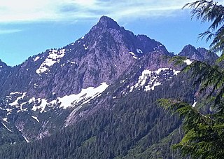
Del Campo Peak is a prominent summit near the western edge of the North Cascades, in Snohomish County of Washington state. It is located south of Barlow Pass along the Mountain Loop Highway near the Monte Cristo area. It is situated on land administered by the Mount Baker-Snoqualmie National Forest. The mountain is named for a mining claim on the mountain's slope. The nearest peak is Gothic Peak, 0.5 miles (0.80 km) to the southwest, and Foggy Pass is the low point between the two peaks. Foggy Lake lies in Gothic Basin below the south face of Del Campo Peak and collects precipitation runoff which ultimately drains to South Fork Sauk River via Weden Creek. Runoff from the west side of the mountain drains into the Sultan River, and the north side drains into headwaters of the Stillaguamish River. In terms of favorable weather, the best months for climbing are July through September.

Sauk City, Washington Unincorporated community in Washington, United States

Sauk City, also known as Sauk, is a former unincorporated community in Skagit County, Washington. It was located along the Skagit River at its confluence with the Sauk River, west of the modern settlement of Rockport.

Hall Peak (Washington)

Hall Peak is a 5,484-foot (1,672-metre) mountain summit located in the South Fork Stillaguamish River Valley near the western edge of the North Cascades, in Snohomish County of Washington state. It is located 5 miles (8.0 km) northwest of Barlow Pass along the Mountain Loop Highway, near the Monte Cristo area, on land administered by the Mount Baker-Snoqualmie National Forest. Its nearest higher peak is Big Four Mountain, one mile to the south-southwest. Both mountains can be prominently seen from the Big Four picnic area, where the trail to the Big Four Ice Caves starts. The peak is named for mining prospector George Hall, who in 1891, discovered the Forty Five claim.

Silvertip Peak

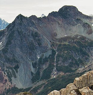
Silvertip Peak is a 6,140-foot (1,870-metre) mountain summit located in the North Cascades, in Snohomish County of Washington state. It is situated 3.5 miles south of Barlow Pass along the Mountain Loop Highway, in the Henry M. Jackson Wilderness, on land managed by Mount Baker-Snoqualmie National Forest. Precipitation runoff from the mountain drains north into tributaries of the Sauk River, or south into headwaters of Silver Creek which is a tributary of Skykomish River. Neighbors surrounding Silvertip include Gothic Peak, Del Campo Peak, Sheep Mountain, Cadet Peak, and Columbia Peak. Silver Lake and Poodle Dog Pass lie on the east flank of Silvertip, the Monte Cristo mining ghost town sits at the northeast base, and the Mineral City ghost town is at the southern foot of this peak. This peak was named in association with the nearby Silver Tip mining claim.

References

  1. "Monte Cristo". Geographic Names Information System . USGS . Retrieved October 29, 2008.
  2. 1 2 3 4 5 6 7 Beckey, Fred (2003). Cascade Alpine Guide: Climbing and High Routes: Stevens Pass to Rainy Pass (3rd ed.). The Mountaineers. pp. 25–30. ISBN   0-89886-423-2.
  3. Cameron, David A. (January 2, 2008). "Monte Cristo -- Thumbnail History". HistoryLink . Retrieved July 30, 2009.
  4. Sykes, Karen (September 25, 1977). "History of Monte Cristo". Seattle Post-Intelligencer . Retrieved October 29, 2008.
  5. Bush, Evan (August 25, 2015). "Donald Trump's grandfather got business start in Seattle". The Seattle Times . Retrieved September 21, 2015.
  6. Millman, Zosha (July 27, 2017). "Trump family local legacy: Not as seedy as once thought?". Seattle Post-Intelligencer.
  7. Cameron, David A. (December 22, 2007). "A devastating flood isolates Monte Cristo (Snohomish County) and begins a new era on December 26, 1980". HistoryLink . Retrieved December 26, 2016.
  8. 1 2 Mulligan, Mark (September 16, 2012). "Cleanup begins of what Monte Cristo miners left behind". The Herald, Everett, Washington. Retrieved March 27, 2013.
  9. "Driving Directions from Everett, WA to Monte Cristo, WA". MapQuest . Retrieved October 29, 2008.
  10. Moyle, Phillip R.; Wasley, Dustin G. (April 2010). Engineering Evaluation / Cost Analysis, Monte Cristo Mining Area (PDF) (Report). Spokane, Washington: Cascade Earth Sciences. Retrieved May 24, 2012.

Further reading