Montrose, Arkansas

Last updated

Montrose, Arkansas
Ashley County Arkansas Incorporated and Unincorporated areas Montrose Highlighted 0546670.svg
Location of Montrose in Ashley County, Arkansas.
Coordinates: 33°17′57″N91°29′55″W / 33.29917°N 91.49861°W / 33.29917; -91.49861
Country United States
State Arkansas
County Ashley
Area
[1]
  Total0.38 sq mi (0.98 km2)
  Land0.38 sq mi (0.98 km2)
  Water0.00 sq mi (0.00 km2)
Elevation
[2]
125 ft (38 m)
Population
 (2020)
  Total243
  Density641.16/sq mi (247.83/km2)
Time zone UTC-6 (Central (CST))
  Summer (DST) UTC-5 (CDT)
ZIP code
71658
Area code 870
FIPS code 05-46670
GNIS feature ID2404294 [2]
Website www.cityofmontrose.net

Montrose is a city in Ashley County, Arkansas, United States. The population was 354 at the 2010 census. [3] Montrose is located where U.S. Route 165 intersects with U.S. Route 82. The town was heavily damaged by an EF2 tornado on January 2, 2023. [4]

Contents

Geography

According to the United States Census Bureau, the city has a total area of 0.46 square miles (1.2 km2), all land. [3]

Demographics

Historical population
CensusPop.Note
1920 404
1930 4316.7%
1940 343−20.4%
1950 3440.3%
1960 39916.0%
1970 55839.8%
1980 64114.9%
1990 528−17.6%
2000 526−0.4%
2010 354−32.7%
2020 243−31.4%
U.S. Decennial Census [5]

2020 census

Montrose racial composition [6]
RaceNum.Perc.
White (non-Hispanic)4518.52%
Black or African American (non-Hispanic)17471.6%
Asian 10.41%
Other/Mixed 72.88%
Hispanic or Latino 166.58%

As of the 2020 United States census, there were 243 people, 152 households, and 113 families residing in the city.

2000 census

As of the census [7] of 2000, there were 526 people, 188 households, and 129 families residing in the city. The population density was 1,141.2 inhabitants per square mile (440.6/km2). There were 220 housing units at an average density of 477.3 per square mile (184.3/km2). The racial makeup of the city was 26.24% White, 71.86% Black or African American, 1.71% from other races, and 0.19% from two or more races. 1.90% of the population were Hispanic or Latino of any race.

There were 188 households, out of which 36.2% had children under the age of 18 living with them, 45.7% were married couples living together, 17.6% had a female householder with no husband present, and 30.9% were non-families. 27.7% of all households were made up of individuals, and 13.3% had someone living alone who was 65 years of age or older. The average household size was 2.80 and the average family size was 3.45.

In the city, the population was spread out, with 32.3% under the age of 18, 9.1% from 18 to 24, 27.4% from 25 to 44, 19.4% from 45 to 64, and 11.8% who were 65 years of age or older. The median age was 33 years. For every 100 females, there were 91.3 males. For every 100 females age 18 and over, there were 86.4 males.

The median income for a household in the city was $20,625, and the median income for a family was $22,361. Males had a median income of $24,688 versus $15,536 for females. The per capita income for the city was $10,363. About 30.4% of families and 34.9% of the population were below the poverty line, including 51.0% of those under age 18 and 28.8% of those age 65 or over.

Education

It is in the Lakeside School District. [8]

Related Research Articles

<span class="mw-page-title-main">Gassville, Arkansas</span> City in Arkansas, United States

Gassville is a city in Baxter County, Arkansas, United States. According to the 2020 census, the city population was 2,171.

<span class="mw-page-title-main">Monette, Arkansas</span> City in Arkansas, United States

Monette is a city in Craighead County, Arkansas, United States. The city is located in an area of Northeast Arkansas known as Buffalo Island. The population was 1,506 at the 2020 census.

<span class="mw-page-title-main">Mountainburg, Arkansas</span> City in Arkansas, United States

Mountainburg is a town in Crawford County, Arkansas, United States. It is part of the Fort Smith, Arkansas-Oklahoma Metropolitan Statistical Area. As of the 2010 census the population was 631.

<span class="mw-page-title-main">Mayflower, Arkansas</span> City in Arkansas, United States

Mayflower is a city in Faulkner County, Arkansas, United States. The population was 2,234 at the 2010 census, up from 1,631 at the 2000 census. It is located in the Central Arkansas region.

<span class="mw-page-title-main">Vilonia, Arkansas</span> City in Arkansas, United States

Vilonia is a city in Faulkner County, Arkansas, United States. Its population was 4,288 in 2020 and estimated at4,429 in 2021, up from 3,815 at the 2010 census and 2,106 at the 2000 census. It is part of the Central Arkansas region.

<span class="mw-page-title-main">Elaine, Arkansas</span> City in Arkansas, United States

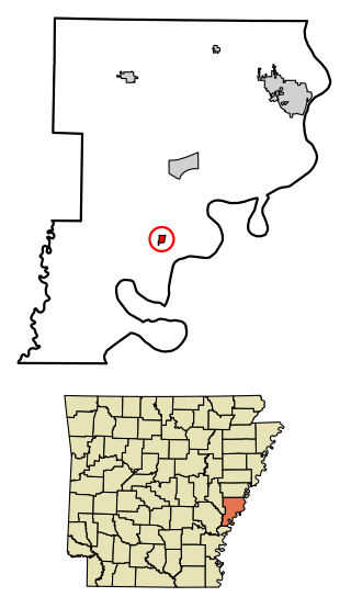
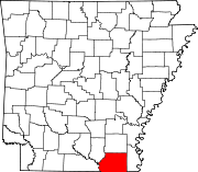
Elaine is a small town in Phillips County, Arkansas, United States, in the Arkansas Delta region of the Mississippi River. The population was 636 at the 2010 census.

<span class="mw-page-title-main">Evening Shade, Arkansas</span> City in Arkansas, United States

Evening Shade is a city in southwest Sharp County, Arkansas, United States. The population was 428 in 2020.

<span class="mw-page-title-main">Hardtner, Kansas</span> City in Kiowa County, Kansas

Hardtner is a city in Barber County, Kansas, United States. As of the 2020 census, the population of the city was 167. It is located 1 mile north of the Kansas / Oklahoma state border.

<span class="mw-page-title-main">Selden, Kansas</span> City in Sheridan County, Kansas

Selden is a city in Sheridan County, Kansas, United States. As of the 2020 census, the population of the city was 184.

<span class="mw-page-title-main">Wellington, Kansas</span> City in Sumner County, Kansas

Wellington is a city in and the county seat of Sumner County, Kansas, United States. As of the 2020 census, the population of the city was 7,715.

<span class="mw-page-title-main">Portage, Michigan</span> City in Michigan, United States

Portage is a city in Kalamazoo County, Michigan, United States. The population was 48,891 at the 2020 census. It is the smaller of the two main cities included in the Kalamazoo-Portage Metropolitan Statistical Area, which had a population of 261,670 in 2020.

<span class="mw-page-title-main">Clarks Grove, Minnesota</span> City in Minnesota, United States

Clarks Grove is a city in Freeborn County, Minnesota, United States. The population was 706 at the 2010 census.

<span class="mw-page-title-main">Hartland, Minnesota</span> City in Minnesota, United States

Hartland is a city in Freeborn County, Minnesota, United States. The population was 315 at the 2010 census.

<span class="mw-page-title-main">Aumsville, Oregon</span> City in Oregon, United States

Aumsville is a city in Marion County, Oregon, United States. The population was 4,234 at the 2020 census. It is part of the Salem Metropolitan Statistical Area.

<span class="mw-page-title-main">Castlewood, South Dakota</span> Town in South Dakota, United States

Castlewood is a city in Hamlin County, South Dakota, United States. It is part of the Watertown, South Dakota Micropolitan Statistical Area. The population was 698 at the 2020 census. and was estimated to be 707 in 2022.

<span class="mw-page-title-main">Montrose, South Dakota</span> City in South Dakota, United States

Montrose is a city in McCook County, South Dakota, United States. The population was 468 at the 2020 census.

<span class="mw-page-title-main">Laguna Heights, Texas</span> Census-designated place in Texas, United States

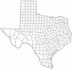
Laguna Heights is a census-designated place (CDP) in Cameron County, Texas, United States. The population was 3,488 at the 2010 census.

<span class="mw-page-title-main">Eustace, Texas</span> City in Texas, United States

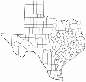
Eustace is a city in Henderson County, Texas, United States. The population was 991 at the 2010 census, up from 798 at the 2000 census.

<span class="mw-page-title-main">Montrose, West Virginia</span> Town in West Virginia, United States

Montrose is a town in Randolph County, West Virginia, United States. The population was 141 at the 2020 census.

<span class="mw-page-title-main">Granite Falls, Minnesota</span> City in Minnesota, United States

Granite Falls is a city located mostly in Yellow Medicine County, Minnesota, of which it is the county seat with a small portion in Chippewa County, Minnesota. The population was 2,737 at the 2020 census. The Andrew John Volstead House, a National Historic Landmark (NHL), is located in Granite Falls. Another NHL located in Granite Falls is the Julian A. Weaver House.

References

  1. "2020 U.S. Gazetteer Files". United States Census Bureau. Retrieved October 29, 2021.
  2. 1 2 U.S. Geological Survey Geographic Names Information System: Montrose, Arkansas
  3. 1 2 "Geographic Identifiers: 2010 Demographic Profile Data (G001): Montrose city, Arkansas". U.S. Census Bureau, American Factfinder. Archived from the original on February 12, 2020. Retrieved May 1, 2013.
  4. "...NWS Damage Survey for 01/02/2023 to 01/03/2023 Tornado Event..." mesonet.agron.iastate.edu. NWS Jackson MS. Retrieved January 5, 2023.
  5. "Census of Population and Housing". Census.gov. Retrieved June 4, 2015.
  6. "Explore Census Data". data.census.gov. Retrieved December 12, 2021.
  7. "U.S. Census website". United States Census Bureau . Retrieved January 31, 2008.
  8. "SCHOOL DISTRICT REFERENCE MAP (2010 CENSUS): Ashley County, AR" (PDF). U.S. Census Bureau . Retrieved March 5, 2021.