Montrose, Virginia

Last updated

Montrose, Virginia
VAMap-doton-Montrose.PNG
Location of Montrose, Virginia
Coordinates: 37°31′14″N77°22′42″W / 37.52056°N 77.37833°W / 37.52056; -77.37833
CountryFlag of the United States.svg  United States
State Flag of Virginia.svg  Virginia
County Flag of Henrico County, Virginia.png Henrico
Area
  Total3.3 sq mi (8.5 km2)
  Land3.2 sq mi (8.3 km2)
  Water0.08 sq mi (0.2 km2)
Elevation
161 ft (49 m)
Population
 (2020)
  Total7,909
  Density2,400/sq mi (930/km2)
Time zone UTC−5 (Eastern (EST))
  Summer (DST) UTC−4 (EDT)
ZIP code
23231
Area code 804
FIPS code 51-52904 [1]
GNIS feature ID1867596 [2]

Montrose is a census-designated place (CDP) in Henrico County, Virginia, United States. The population was 7,909 at the 2020 census. [3]

Contents

Geography

Montrose is located at 37°31′14″N77°22′42″W / 37.52056°N 77.37833°W / 37.52056; -77.37833 (37.520646, 77.378212). [4]

According to the United States Census Bureau, the CDP has a total area of 3.3 square miles (8.5 km2), of which 3.2 square miles (8.3 km2) is land and 0.077 square miles (0.2 km2), or 2.31%, is water. [5]

Demographics

Historical population
CensusPop.Note
1980 5,349
1990 6,40519.7%
2000 7,0189.6%
2010 7,99313.9%
2020 7,909−1.1%
U.S. Decennial Census [6]
2010 [7] 2020 [8]

2020 census

Montrose CDP, Virginia – Racial and ethnic composition
Note: the US Census treats Hispanic/Latino as an ethnic category. This table excludes Latinos from the racial categories and assigns them to a separate category. Hispanics/Latinos may be of any race.
Race / Ethnicity (NH = Non-Hispanic)Pop 2010 [7] Pop 2020 [8] % 2010% 2020
White alone (NH)2,1981,73327.50%21.91%
Black or African American alone (NH)5,2705,38965.93%68.14%
Native American or Alaska Native alone (NH)29290.36%0.37%
Asian alone (NH)82711.03%0.90%
Pacific Islander alone (NH)240.03%0.05%
Some Other Race alone (NH)12570.15%0.72%
Mixed Race or Multi-Racial (NH)1942572.43%3.25%
Hispanic or Latino (any race)2063692.58%4.67%
Total7,9937,909100.00%100.00%

2000 Census

As of the census [1] of 2000, there were 7,018 people, 2,924 households, and 1,850 families residing in the CDP. The population density was 2,062.4 people per square mile (797.0/km2). There were 3,081 housing units at an average density of 905.4/sq mi (349.9/km2). The racial makeup of the CDP was 46.48% White, 49.97% African American, 0.36% Native American, 1.01% Asian, 0.88% from other races, and 1.30% from two or more races. Hispanic or Latino of any race were 1.57% of the population.

There were 2,924 households, out of which 34.3% had children under the age of 18 living with them, 33.9% were married couples living together, 24.8% had a female householder with no husband present, and 36.7% were non-families. 29.9% of all households were made up of individuals, and 9.1% had someone living alone who was 65 years of age or older. The average household size was 2.40 and the average family size was 2.97.

In the CDP, the population was spread out, with 27.4% under the age of 18, 10.3% from 18 to 24, 32.9% from 25 to 44, 19.6% from 45 to 64, and 9.7% who were 65 years of age or older. The median age was 33 years. For every 100 females, there were 82.9 males. For every 100 females age 18 and over, there were 75.8 males.

The median income for a household in the CDP was $36,433, and the median income for a family was $42,031. Males had a median income of $30,903 versus $24,966 for females. The per capita income for the CDP was $17,259. About 9.8% of families and 11.9% of the population were below the poverty line, including 18.0% of those under age 18 and 10.6% of those age 65 or over.

Related Research Articles

<span class="mw-page-title-main">Moores Mill, Alabama</span> Census-designated place in Alabama, United States

Moores Mill is an unincorporated community and census-designated place (CDP) in Madison County, Alabama, United States, and is included in the Huntsville-Decatur Combined Statistical Area. The population was 6,729 at the 2020 census, up from 5,682 at the 2010 census.

<span class="mw-page-title-main">First Mesa, Arizona</span> CDP in Navajo County, Arizona

First Mesa is a census-designated place (CDP) in Navajo County, Arizona, United States, on the Hopi Reservation. As of the 2010 census, the CDP population was 1,555, spread among three Hopi villages atop the 5,700-foot mesa: Hano, Sitsomovi, and Waalpi.

<span class="mw-page-title-main">Green Valley, Maryland</span> Census-designated place in Frederick County, Maryland, United States

Green Valley is an unincorporated area and census-designated place (CDP) in southern Frederick County, Maryland, United States. The population was 12,643 at the 2020 census. The area was listed as a census-designated place in 2000 but not listed as part of any CDP at the 2010 census. It was re-designated a census-designated place for the 2020 census.

<span class="mw-page-title-main">North Tunica, Mississippi</span> CDP in Mississippi, United States

North Tunica is a census-designated place (CDP) in Tunica County, Mississippi. The population was 1,450 at the 2000 census.

<span class="mw-page-title-main">Dooms, Virginia</span> CDP in Virginia, United States

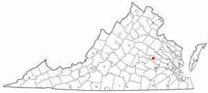
Dooms is a census-designated place (CDP) in Augusta County, Virginia, United States. The population was 1,327 at the 2010 census. It is part of the Staunton–Waynesboro Micropolitan Statistical Area.

<span class="mw-page-title-main">Bellwood, Virginia</span> CDP in Virginia, United States

Bellwood is a census-designated place (CDP) in Chesterfield County, Virginia, United States. The population was 6,352 at the 2010 census. The community takes its name from Bellwood, one of the James River Plantations.

<span class="mw-page-title-main">Bensley, Virginia</span> CDP in Virginia, United States

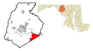
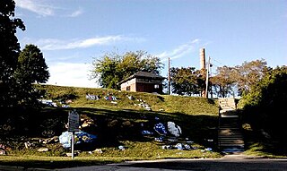
Bensley is a census-designated place (CDP) in Chesterfield County, Virginia, United States. It is an inner suburb of Richmond, Virginia. The population was 5,819 at the 2010 census. Bensley Community building is inside of Bensley park. The community building is outside of Bensley, setting in walking distance of the CDP. The community is an old village with no active government. The community is over 100 years old. A new police substation in the village is next to the old Bensley Bermuda Rescue Squad, near DuPont Spruance.

<span class="mw-page-title-main">Chester, Virginia</span> CDP in Virginia, United States

Chester is a census-designated place (CDP) in Chesterfield County, Virginia, United States. Per the 2020 census, the population was 23,414.

<span class="mw-page-title-main">Chesterfield Court House, Virginia</span> Unincorporated community in Virginia, United States

Chesterfield Court House is an unincorporated community and census-designated place that is the county seat of Chesterfield County, Virginia, United States. It was a census-designated place (CDP) at the 2020 census. It was not delineated as a CDP for the 2010 census. The Chesterfield County Courthouse and Courthouse Square are listed in the National Register of Historic Places. The area is also home of the Chesterfield County Government Complex.

<span class="mw-page-title-main">Ettrick, Virginia</span> CDP in Virginia, United States

Ettrick is a census-designated place (CDP) in Chesterfield County, Virginia, United States. Per the 2020 census, the population was 7,241. The town is home to Virginia State University and the Petersburg Amtrak train station.

<span class="mw-page-title-main">Great Falls, Virginia</span> Census-designated place in Virginia, United States

Great Falls is a census-designated place in Fairfax County, Virginia, United States. The population at the 2020 census was 15,953.

<span class="mw-page-title-main">Chamberlayne, Virginia</span> Census-designated place in Virginia

Chamberlayne is a census-designated place (CDP) in Henrico County, Virginia, United States. The population was 5,581 at the 2020 census.

<span class="mw-page-title-main">Dumbarton, Virginia</span> Census-designated place in Virginia

Dumbarton is a census-designated place (CDP) in Henrico County, Virginia, United States. The population was 7,879 at the 2010 census.

<span class="mw-page-title-main">East Highland Park, Virginia</span> Census-designated place in Virginia

East Highland Park is a census-designated place (CDP) in Henrico County, Virginia, in the United States. The population was 15,131 at the 2020 census.

<span class="mw-page-title-main">Highland Springs, Virginia</span> Census-designated place in Virginia

Highland Springs is a census-designated place (CDP) located in Henrico County, Virginia, United States, 4.3 miles (7 km) east of Richmond. The population was 16,604 at the 2020 census.

<span class="mw-page-title-main">Lakeside, Virginia</span> Census-designated area in Virginia

Lakeside is a census-designated place (CDP) in Henrico County, Virginia, United States. It is an inner suburb of Richmond, Virginia. The population was 12,203 at the 2020 census.

<span class="mw-page-title-main">Wyndham, Virginia</span> Census-designated place in Virginia

Wyndham is a census-designated place (CDP) in Henrico County, Virginia, United States, in the West End area outside of Richmond. The population was 9,785 at the 2010 census. The CDP is named for Wyndham, a planned community there. It is an affluent suburb of Richmond, Virginia.

<span class="mw-page-title-main">Rushmere, Virginia</span> Census-designated place in Virginia, United States

Rushmere is a census-designated place (CDP) in Isle of Wight County, Virginia, United States. The population was 1,018 at the 2010 census.

Hollins is a census-designated place (CDP) in Botetourt and Roanoke County, Virginia, United States. Hollins covers much of the area known locally as "North County". The population was 15,574 at the 2020 census. It is part of the Roanoke Metropolitan Statistical Area. The area is also the home of Hollins University in addition to four properties listed on the National Register of Historic Places: the Black Horse Tavern-Bellvue Hotel and Office, Harshbarger House, the Hollins College Quadrangle, and Old Tombstone.

<span class="mw-page-title-main">Dranesville, Virginia</span> Census-designated place in Virginia, United States

Dranesville is a census-designated place (CDP) in Fairfax County, Virginia, United States. Dranesville is located on the Leesburg Pike at its intersection with Georgetown Pike. The U.S. Census Bureau defines Dranesville as a census-designated place (CDP) with a population of 11,921 as of 2010. At the 2020 Census the population was 11,785.

References

  1. 1 2 "U.S. Census website". United States Census Bureau . Retrieved January 31, 2008.
  2. "US Board on Geographic Names". United States Geological Survey. October 25, 2007. Retrieved January 31, 2008.
  3. "Montrose CDP, Virginia". United States Census Bureau . Retrieved January 30, 2022.
  4. "US Gazetteer files: 2010, 2000, and 1990". United States Census Bureau. February 12, 2011. Retrieved April 23, 2011.
  5. "Geographic Identifiers: 2010 Demographic Profile Data (G001): Montrose CDP, Virginia". United States Census Bureau . Retrieved August 6, 2012.
  6. "Decennial Census of Population and Housing by Decades". US Census Bureau.
  7. 1 2 "P2 Hispanic or Latino, and Not Hispanic or Latino by Race – 2010: DEC Redistricting Data (PL 94-171) - Montrose CDP, Virginia". United States Census Bureau .
  8. 1 2 "P2 Hispanic or Latino, and Not Hispanic or Latino by Race – 2020: DEC Redistricting Data (PL 94-171) - Montrose CDP, Virginia". United States Census Bureau .