Morganza, Louisiana

Last updated

Morganza, Louisiana
Village
Village of Morganza
Pointe Coupee Parish Louisiana Incorporated and Unincorporated areas Morganza Highlighted.svg
Location of Morganza in Pointe Coupee Parish, Louisiana.
Louisiana in United States (US48).svg
Location of Louisiana in the United States
Coordinates: 30°44′08″N91°36′36″W / 30.73556°N 91.61000°W / 30.73556; -91.61000
CountryUnited States
StateLouisiana
Parish Pointe Coupee
Incorporated1908
Government
  MayorClarence "Woots" Wells (D) [1]
Area
[2]
  Total1.38 sq mi (3.58 km2)
  Land1.21 sq mi (3.12 km2)
  Water0.18 sq mi (0.46 km2)
Elevation
36 ft (11 m)
Population
 (2020)
  Total525
  Density435.68/sq mi (168.15/km2)
Time zone UTC-6 (CST)
  Summer (DST) UTC-5 (CDT)
ZIP code
70759
Area code 225
GNIS feature ID537212 [3]
FIPS code 22-52075

Morganza is an incorporated village near the Mississippi River in Pointe Coupee Parish, Louisiana, United States. The population was 610 at the 2010 census, down from 659 in 2000. As of 2020 the population was 525. It is part of the Baton Rouge metropolitan statistical area. The village's zip code is 70759. The Morganza Spillway, a flood control structure between the Mississippi River and the Atchafalaya Basin, is located nearby.

Contents

History

Old Morganza High School Morganza High School, Morganza Louisiana 2008.jpg
Old Morganza High School

Morganza takes its name from Morganza Plantation, the antebellum holding of Charles Morgan, an early surveyor, political figure and first American sheriff of Pointe Coupee Parish. [4] Morgan, the son of James Morgan from a town of the family's name in Sayreville, New Jersey, and a captain in the Second Regiment of the Middlesex County (N.J.) militia during the Revolutionary War. Evidence indicates he was involved in the transfer of slaves from New Jersey to Louisiana in conflict with New Jersey law. [5] The U.S. Post Office opened in 1847, closed some years later, and reopened in 1899. Members of the Campbell family held the position of postmaster until 1970. The town was not incorporated until 1908.

Morganza was the site of a Union Army encampment during the American Civil War. The largest battle in Pointe Coupee Parish was fought at nearby Stirling Plantation, on September 29, 1863. Sixteen Federal troops were killed, 45 were wounded, and 462 were taken prisoner. The Confederate losses included 26 dead, 85 wounded, and 10 missing. Although the Battle of Sterling Plantation was a Confederate victory, the Union troops burned the town of Morganza to the ground on October 1, 1863. [6]

Historian John D. Winters in The Civil War in Louisiana (1963) documents the arrival in May 1864 of Federal troops in Morganza under General Nathaniel P. Banks, recently defeated in the Battle of Mansfield in DeSoto Parish and abandoning the Red River Campaign. According to Winters, conditions were miserable, with extreme heat, excessive rainfall, and epidemics of various illnesses. [7]

To commemorate the centennial anniversary of the Village of Morganza, U.S. Congressman Rodney Alexander entered a speech about the village into the Congressional Record on December 10, 2008. [8]

Periodic flooding

Located at the lower end of a sharp bend of the Mississippi River, Morganza has been subjected to flooding by the great river a number of times. Levee breaches or "crevasses" occurred at Morganza and Grand Levee just downriver in 1850, 1865, 1867, and 1890. The Morganza Spillway, a major flood diversion project of the U.S. Army Corps of Engineers, is located immediately north of the town. Construction on this mammoth work began in 1939 and was completed in 1955. High water of the Mississippi is channeled between guide levees north and west of the town of Morganza and down into the Atchafalaya Basin, thence to the Gulf of Mexico. The floodgates of this facility have been used only twice—during the high water of 1973 and 2011. The structure will be used again in the summer of 2019.

Geography

Morganza is located at 30°44′8″N91°35′36″W / 30.73556°N 91.59333°W / 30.73556; -91.59333 (30.735681, -91.593390). [9]

According to the United States Census Bureau, the village has a total area of 1.4 square miles (3.6 km2), of which 1.2 square miles (3.1 km2) is land and 0.2 square miles (0.52 km2) (15.11%) is water.

Climate

Climate is characterized by relatively high temperatures and evenly distributed precipitation throughout the year. The coldest month is usually quite mild, although frosts are not uncommon, and winter precipitation is derived primarily from frontal cyclones along the polar front. The Köppen Climate Classification subtype for this climate is "Cfa". (Humid Subtropical Climate). [10]

Climate data for Morganza, Louisiana
MonthJanFebMarAprMayJunJulAugSepOctNovDecYear
Mean daily maximum °C (°F)17
(63)
18
(65)
22
(72)
26
(79)
29
(85)
33
(91)
33
(92)
33
(92)
31
(88)
27
(81)
22
(72)
18
(64)
26
(79)
Mean daily minimum °C (°F)4
(40)
6
(43)
10
(50)
13
(56)
17
(63)
21
(69)
22
(72)
22
(71)
19
(66)
13
(55)
8
(46)
5
(41)
13
(56)
Average precipitation mm (inches)140
(5.4)
120
(4.9)
130
(5.0)
130
(5.3)
130
(5.2)
100
(4.1)
130
(5.1)
110
(4.5)
99
(3.9)
74
(2.9)
110
(4.2)
150
(5.9)
1,423
(56.4)
Source: Weatherbase [11]

Demographics

Historical population
CensusPop.Note
1910 296
1920 33212.2%
1930 60883.1%
1940 74422.4%
1950 8179.8%
1960 93714.7%
1970 836−10.8%
1980 8461.2%
1990 759−10.3%
2000 659−13.2%
2010 610−7.4%
2020 525−13.9%
U.S. Decennial Census [12]

As of the census [13] of 2000, there were 659 people, 264 households, and 191 families residing in the village. By 2020, its population was 525.

Government

The Village of Morganza is a municipality led by an elected Mayor along with three Council members. Clarence "Woots" Wells took office as Mayor in January 2019. His Council consists of Paul Wells, Julie Langlois, and Elton Savoy Jr. The Mayor and Council hold a public meeting at the town hall on the first Tuesday of every month.

Morganza, LA Police.jpg

The Morganza Police Department patrols an area of approximately 1.4 square miles (3.6 km2). The head of this agency is an appointed official, with the position currently held by Chief of Police Mark Ramagos. [14] The department's main office is located at 112 LA Highway 3050. Its main area of responsibility is law enforcement and community service within the corporate limits of the Village of Morganza, although its officers are occasionally tasked to assist other area police agencies such as the Pointe Coupee Parish Sheriff's Office, the Louisiana State Police, and Louisiana Wildlife & Fisheries. The Morganza Police Department has a strong traffic enforcement presence along Louisiana Highway 1 and Louisiana Highway 10.

Media

The town features in the 1969 film Easy Rider, where the main characters are subjected to ridicule from townsfolk in a local restaurant. Several scenes in the movie were filmed on location in Morganza. The old restaurant building was demolished in 2016, but is commemorated with a plaque in the sidewalk.

Morganzia on Norman's chart of the lower Mississippi River in 1858 Morganzia on Norman's chart of the lower Mississippi River in 1858.png
Morganzia on Norman's chart of the lower Mississippi River in 1858

Notable person

See also

Related Research Articles

<span class="mw-page-title-main">West Baton Rouge Parish, Louisiana</span> Parish in Louisiana, United States

West Baton Rouge Parish is one of the sixty-four parishes in the U.S. state of Louisiana. Established in 1807, its parish seat is Port Allen. With a 2020 census population of 27,199 residents, West Baton Rouge Parish is part of the Baton Rouge metropolitan statistical area.

<span class="mw-page-title-main">Pointe Coupee Parish, Louisiana</span> Parish in Louisiana, United States

Pointe Coupee Parish is a parish located in the U.S. state of Louisiana. As of the 2020 census, the population was 20,758. The parish seat is New Roads.

<span class="mw-page-title-main">Fordoche, Louisiana</span> Town in Louisiana, United States

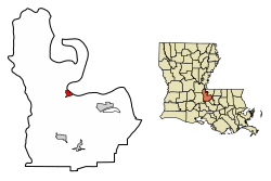
Fordoche is a town in Pointe Coupee Parish, Louisiana, United States. The population was 928 at the 2010 census. It is part of the Baton Rouge Metropolitan Statistical Area.

<span class="mw-page-title-main">New Roads, Louisiana</span> City in Louisiana, United States

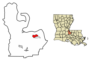
New Roads is a city in and the parish seat of Pointe Coupee Parish, Louisiana, United States. The center of population of Louisiana was located in New Roads in 2000. The population was 4,831 at the 2010 census, down from 4,966 in 2000. In the 2020 census the population was 4,549, while at the beginning year of 2023 the census showed a population of 4,205 and expects to be under 4,000 by the years end. The city's ZIP code is 70760. It is part of the Baton Rouge Metropolitan Statistical Area.

<span class="mw-page-title-main">Morgan City, Louisiana</span> City in Louisiana, United States

Morgan City is a small city in St. Mary Parish, Louisiana, United States, located in the Acadiana region. The population was 11,472 at the 2020 census. Known for being "right in the middle of everywhere", Morgan City is located 68 miles (109 km) southeast of Lafayette, 64 miles (103 km) south of Baton Rouge, and 86 miles (138 km) west of New Orleans.

<span class="mw-page-title-main">Old River Control Structure</span> Floodgate system in Louisiana, USA

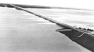
The Old River Control Structure is a floodgate system in a branch of the Mississippi River in central Louisiana. It regulates the flow of water from the Mississippi into the Atchafalaya River, thereby preventing the Mississippi River from changing course. Completed in 1963, the complex was built by the U.S. Army Corps of Engineers in a side channel of the Mississippi known as "Old River", between the Mississippi's current channel and the Atchafalaya Basin, a former channel of the Mississippi.

<span class="mw-page-title-main">Atchafalaya Basin</span> Largest wetland and swamp in the United States

The Atchafalaya Basin, or Atchafalaya Swamp, is the largest wetland and swamp in the United States. Located in south central Louisiana, it is a combination of wetlands and river delta area where the Atchafalaya River and the Gulf of Mexico converge. The river stretches from near Simmesport in the north through parts of eight parishes to the Morgan City southern area.

<span class="mw-page-title-main">Louisiana Highway 10</span> State highway in Louisiana, United States

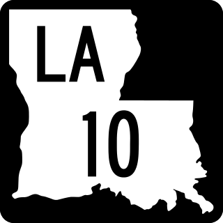
Louisiana Highway 10 (LA 10) is a state highway located in southern Louisiana. It runs 255.51 miles (411.20 km) in an east–west direction from U.S. Highway 171 (US 171) south of Leesville to the Mississippi state line east of Bogalusa.

<span class="mw-page-title-main">Morganza Spillway</span> Flood-control structure in Louisiana, U.S.

The Morganza Spillway or Morganza Control Structure is a flood-control structure in the U.S. state of Louisiana. It is located along the western bank of the Lower Mississippi River at river mile 280, near Morganza in Pointe Coupee Parish. The spillway stands between the Mississippi and the Morganza Floodway, which leads to the Atchafalaya Basin and the Atchafalaya River in south-central Louisiana. Its purpose is to divert water from the Mississippi River during major flood events by flooding the Atchafalaya Basin, including the Atchafalaya River and the Atchafalaya Swamp. The spillway and adjacent levees also help prevent the Mississippi from changing its present course through the major port cities of Baton Rouge and New Orleans to a new course down the Atchafalaya River to the Gulf of Mexico. The Morganza Spillway, operated by the U.S. Army Corps of Engineers, was opened during the 1973 and 2011 Mississippi River floods.

Elliot City is a ghost town that was located in Pointe Coupee Parish's 10th Ward, approximately 6 miles west of Livonia, Louisiana United States. The site of the town itself is located at coordinates 30.555942, -91.662475, and is covered or partially covered by the current U.S. Route 190 roadway.

East Krotz Springs is a ghost town that was located in Pointe Coupee Parish's 1st Ward, approximately 12 miles west of Livonia, Louisiana, United States. The site of the town itself is located at coordinates 30°32'12.87"N, 91°44'24.59"W, and is abandoned. United States Geological Survey maps from 1948 show the town to be located on the east bank of the Atchafalaya River at the mouth of Bayou Sherman, directly across from Krotz Springs, south of the railroad bridge.

McCrea is an unincorporated community on the east bank of the Atchafalaya River in the northwestern portion of Pointe Coupee Parish, Louisiana, United States. It is located along Louisiana Highway 417, some distance north of East Krotz Springs. A post office opened here in 1902 but was discontinued in 1954.

Torras is the name of a former town in the extreme northeastern corner of Pointe Coupee Parish, Louisiana, United States. The town was located along either side of the Texas & Pacific Railroad at its juncture with Lower Old River. The Mississippi River is located just to the east and the juncture of the Red and Atchafalaya Rivers just to the west.

The Battle of Stirling's Plantation was an American Civil War battle took place on September 29, 1863 in Pointe Coupee Parish, Louisiana.

The Sherburne Complex is a joint land management venture of the U.S. Fish and Wildlife Service, the Louisiana Department of Wildlife and Fisheries (LDWF), and the U.S. Army Corps of Engineers that began in 1983. The area consists of 43,637 acres (17,659 ha), and is managed by the Louisiana Department of Wildlife and Fisheries. The complex is located in the Morganza Flood way system of the Atchafalaya Basin about 30 miles (48 km) west of Baton Rouge, Louisiana and actually extends a little south of the I-10 Atchafalaya Basin Bridge at Whiskey Bay, Louisiana. The bridge crosses the Whiskey Bay Pilot Channel. Located on the graveled LA 975, the west boundary is on the east side of the Atchafalaya River with the east boundary being the East Protection Levee. The complex stretches just north of old highway 190, and a short distance to the south of I-10. The nearest town is Krotz Springs to the north off US 190.

<span class="mw-page-title-main">Louisiana Highway 975</span> Highway in Louisiana

Louisiana Highway 975 (LA 975) is a gravel state highway in central Louisiana. It runs north–south for 18.4 miles (29.6 km). The southern terminus is at Whiskey Bay in Iberville Parish, and the northern terminus is east of Krotz Springs at a junction with U.S. Route 190 (US 190) and the north, south LA 973, in Pointe Coupee Parish. The entire route traverses the Sherburne Complex WMA, which is a combined Sherburne WMA, Atchafalaya National Wildlife Refuge, and Bayou Des Ourse, managed by the Louisiana Department of Wildlife and Fisheries. The road runs between the Atchafalaya River and Whiskey Bay Pilot Channel on the west and the East Protection Levee on the east.

<span class="mw-page-title-main">2011 Mississippi River floods</span> 2011 major floods in the United States

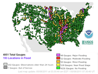
Major floods along the Mississippi River in April and May 2011 were among the largest and most damaging recorded along the U.S. waterway in the past century, comparable in extent to the Great Mississippi Flood of 1927 and Great Flood of 1993. In April 2011, two large storm systems deposited record levels of rainfall on the Mississippi River drainage basin. When that additional water combined with the springtime snowmelt, the river and many of its tributaries began to swell to record levels by the beginning of May. Flooding occurred in Illinois, Missouri, Kentucky, Tennessee, Arkansas, Mississippi, and Louisiana.

<span class="mw-page-title-main">Mississippi flood of 1973</span> Severe weather event in the southern United States

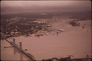
The Mississippi flood of 1973 occurred between March and May 1973 on the lower Mississippi River. The flooding was the third most severe along the U.S.'s Mississippi River during the 20th century.

<span class="mw-page-title-main">West Atchafalaya Floodway</span>

The West Atchafalaya Floodway is a flood control structure of the Mississippi River and Tributaries Project located in the Lower Atchafalaya Basin in south-central Louisiana. It has a project design flood flow capacity of 250,000 cu ft/s (7,100 m3/s).

Red Cross is a ghost town that was located in Pointe Coupee Parish's 1st Ward, approximately 12 miles west of Morganza, Louisiana, United States. The site of the town itself is located at coordinates 30°32'12.87"N, 91°44'24.59"W, at the intersection of the southern terminus of Louisiana Highway 417 and Louisiana Highway 10. The town is now abandoned. United States Geological Survey maps from 1948 show the town to be located on the east bank of the Atchafalaya River, directly across from Melville, Louisiana, slightly north of the railroad bridge.

References

  1. "Election Returns: Point Coupee Parish". Louisiana Secretary of State. November 6, 2018. Retrieved November 9, 2018.
  2. "2020 U.S. Gazetteer Files". United States Census Bureau. Retrieved March 20, 2022.
  3. U.S. Geological Survey Geographic Names Information System: Morganza, Louisiana
  4. Pointe Coupee: Morganza Archived October 8, 1999, at the Wayback Machine
  5. Pingeon, Frances D., "An Abominable Business: The New Jersey Slave Trade, 1818", "New Jersey History", Vol. 109, 3/4, (1991)
  6. Lockhart, John M. "Roadmap to the Westside", The Riverside Reader , January 21, 2008, page 1. Archived December 14, 2012, at the Wayback Machine
  7. John D. Winters, The Civil War in Louisiana, Baton Rouge: Louisiana State University Press, 1963, ISBN   0-8071-0834-0, p. 38
  8. Hon. Rodney Alexander of Louisiana. "Commending The Centennial Anniversary Of The Village Of Morganza." Congressional Record Extension of Remarks 154:E2364-01 (Wednesday, December 10, 2008) p. E2364-01. Accessed: May 14, 2011.
  9. "US Gazetteer files: 2010, 2000, and 1990". United States Census Bureau. February 12, 2011. Retrieved April 23, 2011.
  10. Climate Summary for Morganza, Louisiana
  11. "Weatherbase.com". Weatherbase. 2013. Retrieved on May 10, 2013.
  12. "Census of Population and Housing". Census.gov. Retrieved June 4, 2015.
  13. "U.S. Census website". United States Census Bureau . Retrieved January 31, 2008.
  14. Morganza Police Department