Morris v. United States

Last updated
Morris v. United States
Seal of the United States Supreme Court.svg
Argued October 26-28, and 31; November 1-4, and 7, 1898
Decided May 1, 1899
Full case nameMorris et al. v. United States
Citations174 U.S. 196 ( more )
19 S. Ct. 649; 43 L. Ed. 946; 1899 U.S. LEXIS 1495
Case history
PriorOn appeal from the Supreme Court of the District of Columbia
Court membership
Chief Justice
Melville Fuller
Associate Justices
John M. Harlan  · Horace Gray
David J. Brewer  · Henry B. Brown
George Shiras Jr.  · Edward D. White
Rufus W. Peckham  · Joseph McKenna
Case opinions
MajorityShiras, joined by Fuller, Harlan, Brewer, Brown
DissentWhite, joined by Peckham
Gray and McKenna took no part in the consideration or decision of the case.

Morris v. United States, 174 U.S. 196 (1899), is a 5-to-2 ruling by the United States Supreme Court which held that the bed under the Potomac River between the District of Columbia and the Commonwealth of Virginia belonged to the United States government rather than nearby private landowners on the District of Columbia side.

Contents

Background

On June 20, 1632, Charles I, King of England, made a land grant in North America to Cecil Calvert, 2nd Baron Baltimore which became the Province of Maryland (later the state of Maryland). [1] This grant set the boundary of Maryland at the low-water mark of the southern bank of the Potomac River. [2] On September 27, 1688, King James II made a land grant in North American to Thomas Colepeper, 2nd Baron Colepeper which became the Colony of Virginia (later the state of Virginia). [3] This grant designated "the Potomac River" as the boundary of Virginia. [4] The conflicting grants led to a long-running border dispute between Maryland and Virginia. [5] The two states settled navigational and riparian water rights in the Maryland–Virginia Compact of 1785, but the boundary dispute continued. [6] [7] [8]

In 1788, the United States Constitution was ratified. The Constitution established an independent zone known as the District of Columbia for the seat of the new government. The Residence Act of 1790 provided for the new capital to be located on the Potomac River, and President George Washington was authorized by the United States Congress to determine the exact location (which he did a year later). [9] The District of Columbia Organic Act of 1801 formally established Congressional jurisdiction over the new District. [10] The Virginia retrocession of 1846-1847 returned that portion of the District of Columbia on the Virginia site of the Potomac River to the state of Virginia. [11] This left in doubt the exact position of the District's border with Virginia (just as Maryland's southern border remained in doubt).

Chief Justice John Marshall, whose heirs were party to the suit. John Marshall by Henry Inman, 1832.jpg
Chief Justice John Marshall, whose heirs were party to the suit.

Shortly after the creation of the District of Columbia, the United States government sold certain plots of land to James M. Marshall; his brother, John Marshall (later Chief Justice of the United States); John L. Kidwell; the Chesapeake and Ohio Canal Company; and several others. [12]

Maryland and Virginia agreed to arbitrate their dispute, and in 1877 the Black-Jenkins Award (as the decision of the arbitration panel is known) placed Virginia's boundary with Maryland at the low-water mark on the Virginia side of the Potomac River. [7]

In 1882, Congress passed legislation providing for the dredging of the Potomac River, and for the dredged material to be used to fill in various tidal basins, marshes, and shores. [12] This created extensive new land along the northern shore of the Potomac River—land which adjoined that of the heirs of James Marshall, John Marshall, and John Kidwell, and the Chesapeake and Ohio Canal Company. Congress passed legislation in August 1886 directing the Attorney General of the United States to protect the interests of the United States to the new land, and giving the courts jurisdiction over these claims. [12]

The heirs and other claimants sued to win title to the lands.

Decision

Majority opinion

Associate Justice George Shiras, Jr. wrote the majority opinion for the Court, joined by Chief Justice Melville Fuller and Justices John Marshall Harlan, David Josiah Brewer, and Henry Billings Brown.

Justice Shiras first laid out the facts of the case in a lengthy syllabus, and established various classes of claimants. [13] The first issue Justice Shiras confronted was whether any of the parties could lay claim to the bed of the Potomac River (and thus the reclaimed lands built by the government). [14] Shiras held that none of the heirs on the Virginia side of the river could make any claim to the riverbed. Neither Lord Colepeper, his heir Thomas Fairfax, 6th Lord Fairfax of Cameron, nor any of Fairfax's heirs had ever seriously asserted title to the riverbed, and the Black-Jenkins Award clearly re-established that the boundary of Virginia ended at the low-water mark and did not extend to the riverbed. [15] Relying on the Supreme Court's previous decision in Martin v. Waddell , 41 U.S. 367 (1842), Justice Shiras argued that none of the Maryland landholders could claim title to the riverbed, either. The majority held the original landholders were to hold the river and its bed in trust for the public, and that after the American Revolution these public trusts passed into the possession of the state (in this case, Maryland and in due time the District of Columbia). [16] Shiras distinguished Fairfax's Devisee v. Hunter's Lessee , 11 U.S. 603 (1813) by noting that Fairfax's Devisee did not involve Maryland or any Marylander claimant. [17] Even if the riverbed had been assigned to Lord Fairfax and his heirs, Shiras concluded, the logic of Martin v. Waddell still held and delivered the lands into the control of the federal government. [18]

The majority dismissed the Kidwell heirs' claim to the newly created land under the same reasoning applied to the Marshall heirs. However, Kidwell's heirs noted that Congress had conveyed the property to Kidwell under a resolution adopted on February 16, 1839. The majority held, however, that Congress did not intend by that resolution to convey the riverbed. [19] The majority relied heavily on the discussion in Illinois Central Railroad v. Illinois , 146 U.S. 387 (1892), Shively v. Bowlby , 152 U.S. 1 (1894), and Mann v. Tacoma Land Company , 153 U.S. 273 (1894), [20] and from the express language of the resolution (which withheld from the grant any lands for public purposes). [21] Shiras produced a highly detailed history of the establishment of the boundaries of the District of Columbia, the plots within its boundaries, and how these plots were conveyed to the private landowners. [22] He concluded that none of the survey reports conveyed an interest in any riverbed. Shiras also noted that in Potomac Steam-Boat Co. v. Upper Potomac Steam-Boat Co. , 109 U.S. 672 (1884), the Supreme Court had held that public streets were not part of any plot, and that Water Street (which bounded the Kidwell land to the south) distinctly separated the private land not only from the street itself but also from the newly created lands beyond it. [23]

As for the canal company's claims, the majority held that since none of the private landowners held riparian rights, the company could not obtain such rights from the private landowners. [24] Nor was there any evidence that Congress was relinquishing its rights to Water Street or the river. [25] The court dismissed the claims of the last landowners, whose property lay between Water Street and the shore, as being improperly based on unofficial land records [26] and for being based on maps and other documents which did not accurately reflect the physical land. [27]

The judgment was affirmed.

Dissent

Justice Edward Douglass White, joined by Justice Rufus Wheeler Peckham, dissented.

Justice White concluded that nothing in the record showed that the United States intended to withdraw the riparian water rights of the landholders when it built Water Street and cut the landholders off from the Potomac River. [28] White also engaged in a lengthy discussion of the laying out of the city's boundaries, and the conveyance of private property to the federal government. [29] There could be no doubt, White argued, that the private landowners intended to give all of their riparian rights to the federal government, and there could be no doubt that the federal government intended to give all riparian rights to those to whom it sold the land. [30] The majority's argument led to a tautology in which no riparian rights existed. [31]

Justice White also examined the conveyance of the federal government's land to the new private landowners in depth as well. [32] In his discussion, White interpreted the "incorrect" maps as indicating the riparian rights to which the new private landowners were entitled (rather than a problem of inaccurate mapping). White concluded several times that the federal government fully intended to convey riparian rights to the new landowners because the government and its agents repeatedly indicated in letters, memoranda, contracts of sale, and other documents and statements its expectation that the waterside landowners were to build and maintain docks, wharves, and quays and improve the riparian rights they enjoyed. To assume otherwise, White concluded, was nonsensical. Either the federal government intended to convey riparian rights, or the government deceptively contemplated building Water Street and cutting the new landowners off from their access. "...the first hypothesis is the one naturally to be assumed." [33] "The contracts for the sale of water lots with riparian rights attached, the reports of the surveyors, and the action of the commissioners, all blend into a harmonious and perfect whole, working from an original conception to a successful consummation of a well-understood result. The contrary view produces discord and disarrangement..." [34]

White also discussed the District of Columbia's lengthy history regarding the regulation of wharves and docks. [35] In his view, the city's treatment of the wharves demonstrated that the wharves were private property on private riverbed land, not private property licensed to be emplaced on a riverbed held in the public trust. [36] White interpreted Potomac Steam-Boat Co. as superimposing an easement on top of existing riparian water rights. [37] It was not, as the majority held, the government's purpose all along to bound the plots of land with Water Street.

Justice White would have overturned the judgment of the lesser court for determination of the riparian rights of the landowners in question.

Assessment

In Morris v. United States, the Supreme Court dealt with what was known as a "top common," a tract of land between a river and the land intended to be occupied and sold to private landowners. [38] Such practices were common in colonial America. [38] Morris v. United States is considered an important case in the evolution of the law of rivers, streams, lakes, and other bodies of water, for it established that such bodies of water and their beds belonged to the public in common and were held in trust by the state for its citizens. [39] [40] The Supreme Court further developed this public trust doctrine in Illinois Central Railroad v. Illinois in 1892 and more recently in Utah Division of State Lands v. United States , 482 U.S. 193, 203 (1987). [40]

See also

Further reading

Related Research Articles

<span class="mw-page-title-main">Conservation easement</span> Type of legal arrangement applying to land

In the United States, a conservation easement is a power invested in a qualified private land conservation organization or government to constrain, as to a specified land area, the exercise of rights otherwise held by a landowner so as to achieve certain conservation purposes. It is an interest in real property established by agreement between a landowner and land trust or unit of government. The conservation easement "runs with the land", meaning it is applicable to both present and future owners of the land. The grant of conservation easement, as with any real property interest, is part of the chain of title for the property and is normally recorded in local land records.

<span class="mw-page-title-main">Potomac River</span> River in the Mid-Atlantic United States

The Potomac River is a major river in the Mid-Atlantic region of the United States that flows from the Potomac Highlands in West Virginia to the Chesapeake Bay in Maryland. It is 405 miles (652 km) long, with a drainage area of 14,700 square miles (38,000 km2), and is the fourth-largest river along the East Coast of the United States and the 21st-largest in the United States. Over 5 million people live within its watershed.

<span class="mw-page-title-main">Great Falls, Virginia</span> Census-designated place in Virginia, United States

Great Falls is a census-designated place (CDP) in Fairfax County, Virginia, United States. The population as of the 2010 census was 15,427, an increase of 80.5% from the 2000 census.

<span class="mw-page-title-main">Berkeley Springs, West Virginia</span> Town in West Virginia, United States

Berkeley Springs is a town in, and the county seat of, Morgan County, West Virginia, United States, in the state's Eastern Panhandle. "Berkeley Springs" is also commonly used to refer to the area in and around the Town of Bath. In 1776, the Virginia Legislature incorporated a town around the springs and named it Bath. Since 1802, it has been referred to by the name of its original Virginia post office, Berkeley Springs. The population of the town was 800 (estimated). The town is located within the Hagerstown–Martinsburg, MD–WV Metropolitan Statistical Area. Berkeley Springs is a sister city to Bath, Somerset, England.

<span class="mw-page-title-main">Northern Neck</span> Region in Virginia, United States

The Northern Neck is the northernmost of three peninsulas on the western shore of the Chesapeake Bay in the Commonwealth of Virginia. The Potomac River forms the northern boundary of the peninsula; the Rappahannock River demarcates it on the south. The Northern Neck encompasses the following Virginia counties: Lancaster, Northumberland, Richmond, King George and Westmoreland; it had a total population of 50,158 as of the 2020 census.

Riparian water rights is a system for allocating water among those who possess land along its path. It has its origins in English common law. Riparian water rights exist in many jurisdictions with a common law heritage, such as Canada, Australia, New Zealand, and states in the eastern United States.

Water right in water law refers to the right of a user to use water from a water source, e.g., a river, stream, pond or source of groundwater. In areas with plentiful water and few users, such systems are generally not complicated or contentious. In other areas, especially arid areas where irrigation is practiced, such systems are often the source of conflict, both legal and physical. Some systems treat surface water and ground water in the same manner, while others use different principles for each.

<span class="mw-page-title-main">Theodore Roosevelt Island</span> Island and memorial in the Potomac River, Washington, D.C., U.S.

Theodore Roosevelt Island is an 88.5-acre (358,000 m2) island and national memorial located in the Potomac River in Washington, D.C. During the Civil War, it was used as a training camp for the United States Colored Troops. The island was given to the federal government by the Theodore Roosevelt Association in memory of the 26th president, Theodore Roosevelt. Until then, the island had been known as My Lord's Island, Barbadoes Island, Mason's Island, Analostan Island, and Anacostine Island.

<span class="mw-page-title-main">History of Washington, D.C.</span>

The history of Washington, D.C., is tied to its role as the capital of the United States. Originally inhabited by an Algonquian-speaking people known as the Nacotchtank, the site of the District of Columbia along the Potomac River was first selected by President George Washington. The city came under attack during the War of 1812 in an episode known as the Burning of Washington. Upon the government's return to the capital, it had to manage the reconstruction of numerous public buildings, including the White House and the United States Capitol. The McMillan Plan of 1901 helped restore and beautify the downtown core area, including establishing the National Mall, along with numerous monuments and museums.

Navigable servitude is a doctrine in United States constitutional law that gives the federal government the right to regulate navigable waterways as an extension of the Commerce Clause in Article I, Section 8 of the constitution. It is also sometimes called federal navigational servitude.

<span class="mw-page-title-main">Mount Vernon Conference</span> Meeting of Virginia and Maryland delegates, March 21–28, 1785

The Mount Vernon Conference was a meeting of delegates from Virginia and Maryland held March 21–28, 1785, to discuss navigational rights in the states' common waterways. On March 28, 1785, the group drew up a thirteen-point proposal to govern the rights of both states on the Potomac River, Pocomoke River, and Chesapeake Bay. Known as the Mount Vernon Compact and formally titled as the Compact of 1785, this agreement not only covered tidewater navigation but also extended to issues such as toll duties, commerce regulations, fishing rights, and debt collection. Ratified by the legislature of both states, the compact helped set a precedent for later meetings between states for discussions into areas of mutual concern.

Head v. Amoskeag Mfg. Co., 113 U.S. 9 (1885), was a U.S. Supreme Court case considering whether a dam constructed on privately owned land served a public purpose and whether having the owner of the dam compensate any adjacent landowner was a legal form of eminent domain.

Fairfax's Devisee v. Hunter's Lessee, 11 U.S. 603 (1813), was a United States Supreme Court case arising out of the acquisition of lands originally granted by the British King Charles II in 1649 to Lord Fairfax in the Northern Neck and westward.

David Stuart was a Virginia physician, politician, and correspondent of George Washington. When Washington became President of the United States, he made Stuart one of three commissioners appointed to design a new United States capital city.

Water law in the United States refers to the Water resources law laws regulating water as a resource in the United States. Beyond issues common to all jurisdictions attempting to regulate water's uses, water law in the United States must contend with:

Maryland v. West Virginia, 217 U.S. 1 (1910), is a 9-to-0 ruling by the United States Supreme Court which held that the boundary between the American states of Maryland and West Virginia is the south bank of the North Branch Potomac River. The decision also affirmed criteria for adjudicating boundary disputes between states, which said that decisions should be based on the specific facts of the case, applying the principles of law and equity in such a way that least disturbs private rights and title to land.

Poole v. Fleeger, 36 U.S. 185 (1837), is a 7-to-0 ruling by the Supreme Court of the United States which held that the states of Kentucky and Tennessee had properly entered into an agreement establishing a mutual border between the two states. The plaintiffs in the case were granted title to property improperly conveyed by the state of Tennessee north of this border. In the ruling, the Supreme Court asserted the fundamental right of states and nations to establish their borders regardless of private contract, and made a fundamental statement about the rights of parties to object to a trial court ruling under the rules of civil procedure.

Wharton v. Wise, 153 U.S. 155 (1894), is a 9-to-0 ruling by the Supreme Court of the United States, which denied a citizen of the state of Maryland a writ of habeas corpus. The appellant, tried and convicted of illegally harvesting oysters from Pocomoke Sound in the Chesapeake Bay, had argued that his right to fish was protected by an interstate compact and that this compact also barred the state of Virginia from trying him. The Supreme Court disagreed on both counts.

Virginia v. Maryland, 540 U.S. 56 (2003), is a case in which the Supreme Court of the United States settled a dispute between the Commonwealth of Virginia and the State of Maryland regarding Virginia's riparian rights to the Potomac River. The Supreme Court held in a 7—2 decision that Maryland has no legal authority to regulate or prohibit Virginia and its political subdivisions from building and improving structures in the river and from drawing water from the river. The decision drew heavily on the Maryland–Virginia Compact of 1785, an agreement between the two states concerning navigational and riparian water rights along the Potomac River.

<span class="mw-page-title-main">District of Columbia (until 1871)</span> History of the District of Columbia as a separate legal entity until 1871

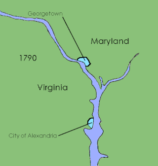
The District of Columbia was created in 1801 as the federal district of the United States, with territory previously held by the states of Maryland and Virginia ceded to the federal government of the United States for the purpose of creating its federal district, which would encompass the new national capital of the United States, the City of Washington. The district came into existence, with its own judges and marshals, through the District of Columbia Organic Act of 1801; previously it was the Territory of Columbia. According to specific language in the U.S. Constitution, it was 100 square miles (259 km2).

References

  1. Brugger, Robert J. Maryland, a Middle Temperament, 1634-1980. Baltimore, Md.: Johns Hopkins University Press, 1996, p. 4-5.
  2. Scott, James Brown. Judicial Settlement of Controversies Between States of the American Union. Oxford, England: Oxford University Press, 1919, p. 473; Risjord, Norman K. Jefferson's America, 1760-1815. Lanham, Md.: Rowman & Littlefield, 2002, p. 217.
  3. Harrison, Fairfax. Virginia Land Grants: A Study of Conveyancing in Relation to Colonial Politics. Westminster, Md.: Willow Bend Books, 1998, p. 75.
  4. Whyte, W. Pinkney and Jones, Isaac D. Boundary Line Between the States of Maryland and Virginia. Before the Honorable Jeremiah S. Black, Honorable William A. Graham, and Honorable Charles J. Jenkins, Arbitrators Upon the Boundary Line Between the States of Virginia and Maryland. Baltimore, Md.: 1874, p. 75.
  5. Cutright, W.B.; Maxwell, Hu; Sayre, R.H.; and Brooks, Earle Amos. The History of Upshur County, West Virginia: From Its Earliest Exploration and Settlement to the Present Time. Baltimore, Md.: Genealogical Pub. Co., 1996, p. 59.
  6. Scott, James Brown. Judicial Settlement of Controversies Between States of the American Union. Oxford, England: Oxford University Press, 1919, p. 484.
  7. 1 2 Zimmerman, Joseph F. Interstate Disputes: The Supreme Court's Original Jurisdiction. Albany, N.Y.: State University of New York, 2006, p. 131-132.
  8. The success of the compact led directly to calls for hold a series of meetings to improve the Articles of Confederation, then the constitutional document of the United States. This meeting turned into the Philadelphia Convention, which subsequently drafted the United States Constitution. See: Dellapenna, Joseph W. "Transboundary Water Allocation in the Twenty-First Century: Colloquiam Article: Interstate Struggles Over Rivers: The Southeastern States and the Struggle Over 'Hooch." New York University Environmental Law Journal. 12:828 (2005), p. 867, n.216.
  9. Furer, Howard B. Washington, A Chronological and Documentary History, 1790-1970. Dobbs Ferry, N.Y.: Oceana Publications, 1975, p. 62.
  10. diGiacomantonio, William C. "'To Make Hay While the Sun Shines': D.C. Governance As An Episode in the Revolution of 1800." In Establishing Congress: The Removal to Washington, D.C., and the Election of 1800. Kenneth R. Bowling and Donald R. Kennon, eds. Columbus, Ohio: Ohio University Press, 2005, p. 39-56.
  11. Tindall, William. Origin and Government of the District of Columbia. Washington, D.C.: U.S. Government Printing Office, 1908, p. 102-108.
  12. 1 2 3 Gutheim, Frederick A. and Lee, Antoinette J. Worthy of the Nation: Washington, D.C., From L'Enfant to the National Capital Planning Commission. Baltimore, Md.: Johns Hopkins University Press, 2006, p. 95-96.
  13. Morris v. United States, 174 U.S. 196, 198-223.
  14. Morris v. United States, 174 U.S. 196, 222-223.
  15. Morris v. United States, 174 U.S. 196, 226.
  16. Morris v. United States, 174 U.S. 196, 227-228.
  17. Morris v. United States, 174 U.S. 196, 230.
  18. Morris v. United States, 174 U.S. 196, 231.
  19. Morris v. United States, 174 U.S. 196, 234.
  20. Morris v. United States, 174 U.S. 196, 236-238.
  21. Morris v. United States, 174 U.S. 196, 242.
  22. Morris v. United States, 174 U.S. 196, 246-266.
  23. Morris v. United States, 174 U.S. 196, 266-269.
  24. Morris v. United States, 174 U.S. 196, 271-272.
  25. Morris v. United States, 174 U.S. 196, 273.
  26. Morris v. United States, 174 U.S. 196, 276.
  27. Morris v. United States, 174 U.S. 196, 277-288.
  28. Morris v. United States, 174 U.S. 196, 292-293.
  29. Morris v. United States, 174 U.S. 196, 295-300.
  30. Morris v. United States, 174 U.S. 196, 300-301.
  31. Morris v. United States, 174 U.S. 196, 307.
  32. Morris v. United States, 174 U.S. 196, 311-343.
  33. Morris v. United States, 174 U.S. 196, 343.
  34. Morris v. United States, 174 U.S. 196, 311-347.
  35. Morris v. United States, 174 U.S. 196, 348-357.
  36. Morris v. United States, 174 U.S. 196, 357.
  37. Morris v. United States, 174 U.S. 196, 358.
  38. 1 2 Martin, Thomas C. "Haunted By History: Colonial Land Trusts Post National Threat." William & Mary Law Review. 48:303 (October 2006), p. 311, n.54.
  39. Schultz, Jr., Warren M. "Property—Classifying Bodies of Water as Lakes or Streams." Tulane Law Review. 49:208 (November 1974), p. 213.
  40. 1 2 Wilkinson, Charles F. "Symposium on the Public Trust and the Waters of the American West: Yesterday, Today and Tomorrow: Introduction and Overview: The Headwaters of the Public Trust: Some Thoughts on the Source and Scope of the Traditional Doctrine." Environmental Law. 19:425 (Spring 1989), p. 455, n.122.