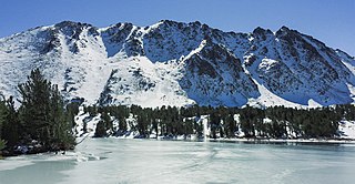
Mount Morrison is located in the Sierra Nevada, in the Sherwin Range. It rises south of Convict Lake near the town of Mammoth Lakes.

Mount Goode is a 13,085-foot-elevation mountain summit located on the crest of the Sierra Nevada mountain range in California, United States. It is situated on the shared boundary of Kings Canyon National Park with John Muir Wilderness, and along the common border of Fresno County with Inyo County. It is also approximately one mile west-northwest of Bishop Pass, one mile east-southeast of Mount Johnson, 1.23 miles (1.98 km) south of Hurd Peak, and 16 miles (26 km) west of the community of Big Pine.

Mount Haeckel is a 13,424-foot (4,092 m) mountain summit located on the crest of the Sierra Nevada mountain range in northern California, United States. It is situated on the shared boundary of Kings Canyon National Park with John Muir Wilderness, and along the common border of Fresno County with Inyo County. It is 21.5 miles (34.6 km) west of the community of Big Pine, 1.27 miles (2.04 km) south-southeast of Mount Darwin, and one mile north-northeast of Mount Fiske, which is the nearest higher neighbor. Mount Haeckel ranks as the 71st highest summit in California.

Red and White Mountain is a remote 12,816-foot-elevation mountain summit located on the crest of the Sierra Nevada mountain range in northern California, United States. It is situated in the John Muir Wilderness on the shared boundary of Sierra National Forest with Inyo National Forest, and along the common border of Fresno County with Mono County. It is eight miles northeast of Lake Thomas A Edison, and approximately 13 miles (21 km) southeast of the community of Mammoth Lakes. The nearest higher neighbor is Red Slate Mountain, 2 miles (3.2 km) to the north-northwest.

North Guard is a remote 13,327-foot-elevation (4,062-meter) mountain summit located near the northern end of the Great Western Divide of the Sierra Nevada mountain range, in Tulare County of northern California. It is situated in Kings Canyon National Park, 0.9 miles (1.4 km) southeast of Mount Farquhar, and 0.6 miles (0.97 km) north-northwest of Mount Brewer, which is the nearest higher neighbor. Topographic relief is significant as the east aspect rises 3,858 feet above East Lake in three miles. North Guard ranks as the 87th highest summit in California, and the second highest point of the northern Great Western Divide. It's not as high as Mount Brewer, but offers better climbing and is considered one of the classic climbing routes in the Sierra Nevada.

The Hermit is a 12,328-foot-elevation (3,758-meter) mountain summit located west of the crest of the Sierra Nevada mountain range, in Fresno County of central California, United States. It is situated in northern Kings Canyon National Park, 2.5 miles (4.0 km) east of Emerald Peak, and 2.5 miles (4.0 km) west of Mount Darwin. Topographic relief is significant as the north aspect rises 2,500 feet above Evolution Valley in less than one mile. The John Muir Trail passes to the east and north of this landmark, providing an approach. This geographical feature was named by Sierra Club explorer Theodore Solomons in 1895 as he wrote: "The traveler will be greatly attracted by a very sharp peak or butte that rises on the south wall. From its isolated position as viewed from the valley we called it the Hermit."

Parker Peak is a 12,861-foot-elevation (3,920-meter) mountain summit located in the Sierra Nevada mountain range, in Mono County of northern California, United States. It is situated in the Ansel Adams Wilderness, on land managed by Inyo National Forest. It is approximately 7.0 miles (11.3 km) northwest of the community of June Lake, 1.2 miles (1.9 km) east of Yosemite National Park's eastern boundary, and 1.0 mile (1.6 km) east of Koip Peak, the nearest higher neighbor. The mountain is visible from the June Lake Loop, and from the nearby June Mountain ski area. Topographic relief is significant as it rises over 5,700 feet above Grant Lake in four miles. The peak's name is derived from Parker Creek, which in turn was named after an early settler of Mono County. This geographical feature's name has been officially adopted by the U.S. Board on Geographic Names. The first ascent of the summit was made in 1914 by Norman Clyde.

Mount McDuffie is a 13,291-foot-elevation (4,051-meter) mountain summit located west of the crest of the Sierra Nevada mountain range, in Fresno County of central California, United States. This peak is situated in northern Kings Canyon National Park, 1.9 miles (3.1 km) northwest of The Citadel, and two miles south of Black Giant, which is the nearest higher neighbor. McDuffie ranks as the 93rd highest summit in California, and the second-highest point on Black Divide. Topographic relief is significant as it rises nearly 4,900 feet above Le Conte Canyon in approximately 2.5 miles. An approach to this remote peak is made possible via the John Muir Trail.

Tunnabora Peak is a 13,563-foot-elevation (4,134-meter) mountain summit located on the crest of the Sierra Nevada mountain range in California. It is situated on the common border of Tulare County with Inyo County, as well as the shared boundary of Sequoia National Park and John Muir Wilderness. It is set above the north shore of Tulainyo Lake, 13 miles (21 km) west of the community of Lone Pine, 1.86 miles (2.99 km) north-northeast of Mount Whitney, and 0.9 miles (1.4 km) north-northwest of Mount Carillon. Tunnabora ranks as the 51st-highest peak in California. Topographic relief is significant as it rises approximately 5,200 feet above Whitney Portal in approximately three miles.

Mount Randy Morgenson is a 13,927-foot-elevation (4,245-meter) mountain summit located along the crest of the Sierra Nevada mountain range in Tulare County, California. It is situated in Sequoia National Park, one mile north-northwest of Mount Whitney, 0.85 mile east of Mount Hale, and one-half mile west of Mount Russell, the nearest higher neighbor. The John Muir Trail traverses to the south of the mountain, providing an approach option. Mt. Morgenson ranks as the 20th-highest summit in California. Topographic relief is significant as the northwest aspect rises 2,200 feet above Wales Lake in less than one mile.
Black Mountain is an 11,797-foot-elevation (3,596 meter) summit located in the Sierra Nevada mountain range, in Mono County of northern California, United States. The mountain is set within the Hoover Wilderness, on the common boundary shared by Inyo National Forest with Humboldt–Toiyabe National Forest, and 1.5 mile outside the boundary of Yosemite National Park. The peak is situated immediately southwest above Virginia Lakes, 1.8 miles (2.9 km) northeast of line parent Excelsior Mountain, and 1.8 miles (2.9 km) south of Dunderberg Peak. Topographic relief is significant as the north aspect rises 1,500 feet above Cooney Lake in one-half mile (0.80 km), and the south aspect rises 3,600 feet above Lundy Canyon in one and a half miles (2.4 km). The first ascent of the summit was made in 1905 by George R. Davis, Albert Hale Sylvester, and Pearson Chapman, all with the United States Geological Survey.

Observation Peak is a 12,362-foot-elevation summit located in Fresno County, California, United States.

Mount Starr, elevation 12,835 feet (3,912 m), is a mountain summit located on the crest of the Sierra Nevada mountain range in northern California, United States. It is situated in the John Muir Wilderness on the common boundary shared by Sierra National Forest with Inyo National Forest, and along the common border of Fresno County with Inyo County. It is bound on the east by Little Lakes Valley, and is 0.8 mile northeast of Mono Pass. Topographic relief is significant as the summit rises 2,300 feet above Little Lakes Valley in approximately one-half mile (0.80 km). Neighbors include Mount Abbot, three miles to the south-southwest, Mount Morgan, 2.5 miles to the southeast, and Pointless Peak is 2.5 miles to the north.

Mount Warren is a 12,327-foot-elevation (3,757 meter) summit located in the Sierra Nevada mountain range, in Mono County, California, United States. The mountain is set within the Hoover Wilderness, on land managed by Inyo National Forest. The peak is situated 1.5 miles (2.4 km) south of Gilcrest Peak, 1.8 miles (2.9 km) northwest of Lee Vining Peak, and 5 miles (8.0 km) southeast of Excelsior Mountain, which is the nearest higher neighbor. Topographic relief is significant as the summit rises 5,955 feet above Mono Lake in 4.5 miles.

Mount Senger is a 12,286-foot-elevation (3,745 meter) mountain summit located west of the crest of the Sierra Nevada mountain range in Fresno County of northern California, United States. It is set within the John Muir Wilderness, on land managed by Sierra National Forest. It is situated 2.2 miles (3.5 km) southeast of Mount Hooper, 2.6 miles (4.2 km) southwest of Gemini, and 2.7 miles (4.3 km) south-southwest of Seven Gables. Senger ranks as the 348th-highest summit in California. Topographic relief is significant as the summit rises over 4,600 feet above the South Fork San Joaquin River in approximately three miles. The John Muir Trail traverses the south and west slopes of the mountain, providing an approach option.

Mount Crocker is a remote 12,458-foot-elevation mountain summit located on the crest of the Sierra Nevada mountain range in northern California, United States. It is situated in the John Muir Wilderness, on the boundary shared by Sierra National Forest with Inyo National Forest, and along the common border of Fresno County with Mono County. Crocker ranks as the 291st-highest summit in California. Topographic relief is significant as the north aspect rises 2,500 feet above McGee Creek in approximately one mile. It is nine miles northeast of Lake Thomas A Edison, and approximately 15 miles (24 km) southeast of the community of Mammoth Lakes.

Mount Stanford is a 12,838-foot-elevation (3,913 meter) mountain summit located on the crest of the Sierra Nevada mountain range in northern California, United States. It is situated in the John Muir Wilderness, on the boundary shared by Sierra National Forest with Inyo National Forest, and along the common border of Fresno County with Mono County. It is 10 miles northeast of Lake Thomas A Edison, and approximately 15 miles (24 km) southeast of the community of Mammoth Lakes. Topographic relief is significant as the north aspect rises 3,200 feet above McGee Creek in approximately 1.75 mile. There is another Mount Stanford in the Sierra Nevada which is named for Stanford University.

Mount Izaak Walton is a 12,077-foot-elevation (3,681 meter) mountain summit located in the Sierra Nevada mountain range in Fresno County of northern California, United States. It is situated in the John Muir Wilderness, on land managed by Sierra National Forest. Mount Izaak Walton ranks as the 404th-highest summit in California. Topographic relief is significant as the northwest aspect rises 1,800 feet above Izaak Walton Lake in approximately one mile. It is six miles northeast of Lake Thomas A Edison, and approximately 14 miles (23 km) south-southeast of the community of Mammoth Lakes. The peak is set on Silver Divide, so precipitation runoff from the north side of this mountain drains into Fish Creek which is a tributary of the San Joaquin River, and from the south slope to Mono Creek, also a tributary of the San Joaquin.
Graveyard Peak is an 11,539-foot-elevation (3,517 meter) mountain summit located in the Sierra Nevada mountain range in Fresno County of northern California, United States. It is situated in the John Muir Wilderness, on land managed by Sierra National Forest. Graveyard Peak ranks as the 535th-highest summit in California, and topographic relief is significant as the south aspect rises over 2,300 feet above Devils Bathtub in approximately one mile. It is two miles southeast of Silver Peak, five miles north of Lake Thomas A Edison, and approximately 13 miles (21 km) south of the community of Mammoth Lakes. The peak is set on Silver Divide, so precipitation runoff from the north side of this mountain drains into Fish Creek which is a tributary of the San Joaquin River, and from the south slope to Lake Thomas A Edison. The peak is most easily reached out of Lake Thomas Edison.

Painted Lady is a 12,126-foot-elevation (3,696-meter) mountain summit located in Fresno County, California.