Mount Constitution

Last updated

Mount Constitution
Mt. Constitution Peak.jpg
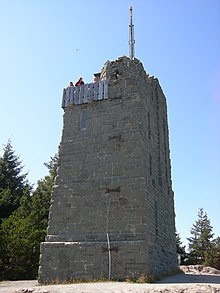
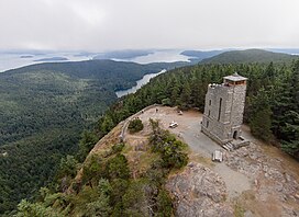
The observation tower at the peak of Mt. Constitution as seen from an unmanned aerial vehicle
Highest point
Elevation 2,399 ft (731 m)  NAVD 88 [1]
Prominence 2,407 ft (734 m) [2]
Coordinates 48°40′39″N122°49′52″W / 48.677569028°N 122.831162383°W / 48.677569028; -122.831162383 [1]
Geography
Location Orcas Island, San Juan County, Washington, U.S.

Mount Constitution is a mountain on Orcas Island, the highest point in the San Juan Islands and the second highest mountain on an ocean island in the contiguous 48 states. Only Devils Peak in the Channel Islands of California is higher. [3]

At the top of Mount Constitution sits a 53-foot sandstone tower, reinforced with 2 tons of steel, and measuring 18 x 28 feet at the base. Moran - Mt. Constitution observation tower 01.jpg
At the top of Mount Constitution sits a 53-foot sandstone tower, reinforced with 2 tons of steel, and measuring 18 x 28 feet at the base.

A stone observation tower patterned after a medieval watch tower stands 52 feet (16 m) above the summit, which is 2,400 feet (730 m) above sea level. [4] It was designed by architect Ellsworth Storey and built by the Civilian Conservation Corps in 1936. [5] The tower offers panoramic views of the surrounding islands, the Cascade Mountains, the Olympic Mountains, and many Canadian and American cities. [4] On a clear day, the view encompasses locations as diverse as Mount Baker, Mount Rainier, Saturna Island, and the cities of Vancouver, and Victoria, British Columbia. Mount Constitution lies within the 5,000-acre (20.2 km2) Moran State Park.

The prominence was named by Charles Wilkes during the Wilkes Expedition of 1838-1842 for the USS Constitution. [6]

Related Research Articles

<span class="mw-page-title-main">Mount Graham</span> Mountain in Arizona, United States

Mount Graham is a mountain in Graham County, Arizona, United States, approximately 70 miles (110 km) northeast of Tucson. The mountain reaches 10,724 feet (3,269 m) in height. It is the highest elevation in Graham County, Coronado National Forest and the Pinaleño Mountains. It is also the southernmost peak and land area in the continental United States above 10,000 feet (3,048 m). As the name "Mount Graham" is often used by locals to refer to the entire mountain range, the peak itself is frequently referred to as "High Peak". It is twentieth of the 57 ultra-prominent peaks of the lower 48 states, and the first of the five in Arizona.

<span class="mw-page-title-main">San Jacinto Peak</span> Mountain in the United States

San Jacinto Peak is a 10,834 ft (3,302 m) peak in the San Jacinto Mountains, in Riverside County, California. Lying within Mount San Jacinto State Park it is the highest both in the range and the county, and serves as the southern border of the San Gorgonio Pass. Naturalist John Muir wrote of San Jacinto Peak, "The view from San Jacinto is the most sublime spectacle to be found anywhere on this earth!"

<span class="mw-page-title-main">Fourteener</span> Mountain peak of at least 14,000 ft.

In the mountaineering parlance of the Western United States, a fourteener is a mountain peak with an elevation of at least 14,000 ft (4267 m). The 96 fourteeners in the United States are all west of the Mississippi River. Colorado has the most (53) of any single state; Alaska is second with 29. Many peak baggers try to climb all fourteeners in the contiguous United States, one particular state, or another region.

<span class="mw-page-title-main">Cheaha Mountain</span> Highest point in Alabama, United States

Cheaha Mountain, often called Mount Cheaha, is the highest natural point in the U.S. state of Alabama. It is located a few miles northwest of the town of Delta in Cheaha State Park, which offers a lodge, a restaurant, and other amenities. The nearest higher peak is Brushy Top in Gilmer County, Georgia, 106.72 miles away.

<span class="mw-page-title-main">Devils Peak (Santa Barbara County, California)</span>

Devils Peak at 2,429 feet (740 m) is the tallest peak on the Channel Islands of California. It is located on Santa Cruz Island within Channel Islands National Park on land owned by The Nature Conservancy. Visiting the area requires a permit.

<span class="mw-page-title-main">Moran State Park</span> State park in Washington (state), US

Moran State Park is a public recreation area on Orcas Island in Puget Sound's San Juan Islands in the state of Washington, United States. The state park encompasses over 5,000 acres of various terrain including forests, wetlands, bogs, hills, and lakes. It is the largest public recreation area in the San Juan Islands and the fourth largest state park in the state. A park focal point is the observation tower atop Mount Constitution, the highest point in San Juan County at 2,407 feet.

<span class="mw-page-title-main">Mount Spickard</span> Mountain in Washington state, USA

Mount Spickard is a 8,980-foot (2,740 m) mountain peak in the North Cascades, a mountain range in the U.S. state of Washington. Located 2 miles (3.2 km) south of the Canada–US border, it is part of the Chilliwack Group, a subrange of the Skagit Range which is part of the North Cascades. It is composed mainly of gneiss and is part of two major drainage basins: that of the Skagit River and Fraser River.

References

  1. 1 2 "Constitution Reset". NGS Data Sheet. National Geodetic Survey, National Oceanic and Atmospheric Administration, United States Department of Commerce.
  2. "Mount Constitution, Washington". Peakbagger.com.
  3. "USA 48-States Island High Points above 500 feet". Peakbagger.com. Retrieved January 17, 2013.
  4. 1 2 McCleary, Kathleen (September 5, 2003). "Salty Breezes. Great Views. This Is Mass Transit?". The New York Times . Retrieved February 13, 2024.
  5. Oldham, Kit (October 29, 2005). "Civilian Conservation Corps begins building an observation tower on Mount Constitution, Orcas Island, in August 1935". HistoryLink . Retrieved February 13, 2024.
  6. Majors, Harry M. (1975). Exploring Washington. Van Winkle Publishing Co. p. 23. ISBN   978-0-918664-00-6.

Commons-logo.svg Media related to Mount Constitution at Wikimedia Commons