
Mount Bertha is a 10,204-foot glaciated mountain summit located in the Fairweather Range of the Saint Elias Mountains, in southeast Alaska, United States.
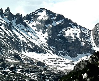
Pagoda Mountain is a 13,497-foot-elevation (4,114-meter) mountain summit in Boulder County, Colorado, United States.
Mount Kiev is a 7,775-foot-elevation (2,370-meter) mountain summit located in Alaska, United States.
Mount Tlingit is a 12,606-foot (3,842-meter) mountain summit in Alaska, United States.

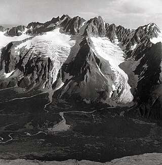
Mount Shouplina is an 8,531-foot-elevation (2,600-meter) mountain summit located 18 miles (29 km) north-northwest of Valdez in the U.S. state of Alaska. This remote glaciated mountain is set in the Chugach Mountains on land managed by Chugach National Forest. Precipitation runoff from the mountain drains south to Prince William Sound and north to Tazlina Lake → Tazlina River → Copper River. Topographic relief is significant as the summit rises 2,100 feet (640 m) above the East Branch Columbia Glacier in 0.4 mile (0.64 km). The first ascent of the summit was made in 1985 by John Weiland, Matt Kinney, and Bob Shelton. The mountain was named in 1959 by mountaineer Lawrence E. Nielsen and the toponym was officially adopted in 1965 by the U.S. Board on Geographic Names. The word "Shouplina" is a portmanteau blending the names of the Shoup Glacier and Tazlina Glacier which flow from this mountain's south and north slopes respectively.
Lindita Peak is a 7,910-foot-elevation (2,411-meter) mountain summit located 17 miles (27 km) north-northwest of Valdez in the U.S. state of Alaska. Lindita is the highest peak at the head of the Tazlina Glacier when viewed from the Glenn Highway at Mile 156 near the Tazlina Glacier Lodge. This remote glaciated mountain is set in the Chugach Mountains on land managed by Chugach National Forest. Precipitation runoff from the mountain drains south to Prince William Sound and north to Tazlina Lake → Tazlina River → Copper River. Topographic relief is significant as the summit rises 2,400 feet (732 m) above the East Branch of the Columbia Glacier in 0.4 mile (0.64 km). The mountain's name Lindita, meaning "little beauty" in Spanish, was applied in 1955 by mountaineer and glaciologist Lawrence E. Nielsen (1917–1992), and the toponym was officially adopted in 1965 by the U.S. Board on Geographic Names. The first ascent of the summit was made on July 1, 1977, by Lawrence E. Nielsen, Halford Joiner, Tom Lamb, and Dr. Randall Travis via the northeast face and the north-facing knife-edged ridge from the Tazlina Glacier.
Tazcol Peak is a 7,850-foot-elevation (2,393-meter) mountain summit located 18 miles (29 km) north-northwest of Valdez in the U.S. state of Alaska. This remote glaciated mountain is set in the Chugach Mountains on land managed by Chugach National Forest. Precipitation runoff from the mountain drains south to Prince William Sound and north to Tazlina Lake → Tazlina River → Copper River. Topographic relief is significant as the summit rises 4,350 feet (1,326 m) above the East Branch of the Columbia Glacier in 1.4 mile (2.25 km). The peak's name was applied in 1959 by mountaineer and glaciologist Lawrence E. Nielsen (1917–1992), and the toponym was officially adopted in 1965 by the U.S. Board on Geographic Names. The word "Tazcol" is a portmanteau blending the names of the Tazlina Glacier and Columbia Glacier which flow from this mountain's north and south slopes respectively.
Icy Peak is a 4,550-foot-elevation (1,390-meter) mountain summit in Alaska, United States.

Mount Stepo is a 3,828-foot-elevation (1,167-meter) mountain summit in Alaska.

Mount Gakona is a 9,865-foot-elevation (3,007-meter) mountain summit in Alaska.

Mount Emmerich is a 6,877-foot-elevation (2,096-meter) mountain summit in Alaska.
Mount Silvertip is a 9,400-foot-elevation (2,865-meter) mountain summit in Alaska.

Institute Peak is an 8,022-foot-elevation (2,445-meter) mountain summit in Alaska.

Mount Dech is a 7,475-foot-elevation (2,278-meter) mountain summit in Alaska.

Rook Mountain is a 6,685-foot-elevation (2,038-meter) mountain summit in Alaska, United States.

Mount Yukla is a 7,569-foot (2,307 m) mountain summit in Alaska, United States.

Mount Eva is a 5,019-foot-elevation (1,530-meter) mountain summit in Alaska, United States.
Mount Sumdum is a 6,666-foot-elevation (2,032-meter) mountain summit in Alaska, United States.
The Rowel is a 9,806-foot-elevation (2,989-meter) mountain summit in Alaska.

Mount Chichantna is a 10,893-foot-elevation (3,320-meter) mountain summit in Alaska.

