Mountain passes that are known to have cycling milestones
The following table lists mountain passes signposted with cycling milestones, ordered by the height of the summit. If a mountain pass is not included in the table below, that does not imply that it has no cycling milestones. It can likewise mean that is not yet documented in this table.
All signs display the standard information (see above). The table specifies the precision of the slope. Additional information and emblems (if any) are explained in the column with remarks.
| Name | Height | Country | Precision of slope | Example and season | Remarks |
|---|---|---|---|---|---|
| Cime de la Bonette from Jausiers uphill | 2,802 m (9,193 ft) | France | 0.1% |  | Emblem left: similar to the one of Jausiers; emblem right: Provence-Alpes-Côte d'Azur; C1: number of road; bold 2: distance from starting point in Jausiers. |
| Cime de la Bonette to Jausiers downhill | 2,802 m (9,193 ft) | France | 0.1% |  | Emblem left: similar to the one of Jausiers; emblem right: Provence-Alpes-Côte d'Azur; C1: number of road; bold 2: distance to starting point in Jausiers. |
| Cime de la Bonette from Saint-Étienne-de-Tinée uphill | 2,802 m (9,193 ft) | France | 1% |  | Emblem left: Métropole Nice Côte d'Azur; Emblem right: Mercantour National Park; M2205: number of road; bold 77: distance from starting point of this road. |
| Cime de la Bonette to Saint-Étienne-de-Tinée downhill | 2,802 m (9,193 ft) | France | 1% |  | Emblem left: Métropole Nice Côte d'Azur; emblem right: Mercantour National Park; M2205: number of road; bold 77: distance to starting point of this road. |
| Col de l'Iseran from Bonneval-sur-Arc uphill only | 2,770 m (9,090 ft) | France | 1% |  | On the side the logo of Savoie and the number of the road (D 902) is displayed. |
| Col de l'Iseran from Val-d'Isère uphill only | 2,770 m (9,090 ft) | France | 1% |  | On the side the logo of Savoie and the number of the road (D 902) is displayed. |
| Col Agnel from Château-Queyras uphill only | 2,744 m (9,003 ft) | France | 0.1% | 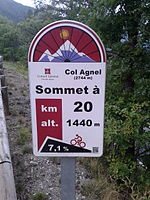 | Emblem:Conseil général Hautes Alpes; 2744 m: height of summit; A QR code is included in the lower right. |
| Col du Galibier from Valloire uphill only | 2,642 m (8,668 ft) | France | 1% |  | On the side the logo of Savoie and the number of the road (D 902) is displayed. |
| Col du Galibier from Col du Lautaret uphill only | 2,642 m (8,668 ft) | France | 0.1% |  | Emblem:Conseil général Hautes Alpes; 2642 m: height of summit; A QR code is included in the lower right. |
| Col d'Izoard from Briançon uphill only | 2,360 m (7,740 ft) | France | 0.1% |  | Emblem:Conseil général Hautes Alpes; 2360 m: height of summit; A QR code is included in the lower right. |
| Col d'Izoard from Guillestre uphill only | 2,360 m (7,740 ft) | France | 0.1% |  | Emblem:Conseil général Hautes Alpes; 2360 m: height of summit; A QR code is included in the lower right. |
| Col de la Cayolle from Barcelonette uphill only | 2,326 m (7,631 ft) | France | 1% |  | Emblem:Conseil général Alpes-de-Haute-Provence; D902: number of road. |
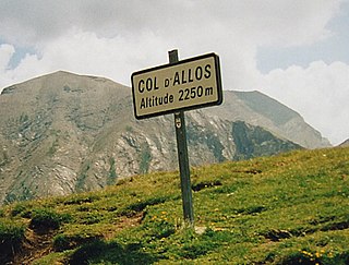
| Col d'Allos from Barcelonette uphill only | 2,250 m (7,380 ft) | France | 1% |  | Emblem:Conseil général Alpes-de-Haute-Provence; D908: number of road. |
| Col du Tourmalet from Sainte-Marie-de-Campan uphill only | 2,115 m (6,939 ft) | France | 0.5% |  | Emblem: Conseil général Hautes-Pyrénées; 2115 m: height of summit. |
| Col du Tourmalet from Luz-Saint-Sauveur uphill only | 2,115 m (6,939 ft) | France | 0.5% |  | Emblem: Conseil général Hautes-Pyrénées; 2115 m: height of summit. |
| Col de Vars from Guillestre uphill only | 2,109 m (6,919 ft) | France | 0.1% |  | Emblem:Conseil général Hautes Alpes; 2109 m: height of summit; A QR code is included in the lower right. |
| Col de Vars from Jausiers uphill only | 2,109 m (6,919 ft) | France | 1% |  | Emblem: Conseil général Alpes-de-Haute-Provence; D902: number of road. |
| Col des Champs from Colmars uphill only | 2,087 m (6,847 ft) | France | 1% |  | Emblem: Conseil général Alpes-de-Haute-Provence; D2: number of road. |
| Col de la Madeleine from La Léchère uphill only | 1,993 m (6,539 ft) | France | 1% |  | On the side (here not visible) the logo of Savoie and the number of the road (D 213) is displayed. |
| Col de la Madeleine from La Chambre uphill only | 1,993 m (6,539 ft) | France | 1% |  | On the side the logo of Savoie and the number of the road (D 213) is displayed. |
| Col du Glandon from La Chambre uphill only | 1,924 m (6,312 ft) | France | 1% |  | On the side the logo of Savoie and the number of the road (D 927) is displayed. |
| Col de la Couillole from Saint-Sauveur-sur-Tinée up- and downhill | 1,679 m (5,509 ft) | France | 1% |  | M30: number of road; bold 11: distance from and to starting point in Saint-Sauveur-sur-Tinée |
| Peyragudes from Col de Peyresourde uphill only | 1,620 m (5,310 ft) | France | 0.5% |  | Emblem: Conseil général Hautes-Pyrénées; 1620 m: height of summit. |
| Col de Peyresourde from Armenteule uphill only | 1,569 m (5,148 ft) | France | 0.5% |  | Emblem: Conseil général Hautes-Pyrénées; 1569 m: height of summit. |
| Col du Télégraphe from Saint-Michel-de-Maurienne uphill only | 1,566 m (5,138 ft) | France | 1% |  | On the side the logo of Savoie and the number of the road (D 902) is displayed. |
| Hourquette d'Ancizan from Payolle uphill only | 1,564 m (5,131 ft) | France | 0.1% |  Summer 2015 Summer 2015 | Emblem: Conseil général Hautes-Pyrénées; 1564 m: height of summit. |
| Hourquette d'Ancizan from Ancizan uphill only | 1,564 m (5,131 ft) | France | 0.1% |  Summer 2015 Summer 2015 | Emblem: Conseil général Hautes-Pyrénées; 1564 m: height of summit. |
| Col d'Aspin from Sainte-Marie-de-Campan uphill only | 1,489 m (4,885 ft) | France | 0.5% |  | Emblem: Conseil général Hautes-Pyrénées; 1489 m: height of summit. |
| Col d'Aspin from Arreau uphill only | 1,489 m (4,885 ft) | France | 0.5% | 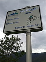 | Emblem: Conseil général Hautes-Pyrénées; 1489 m: height of summit. |
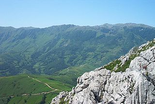
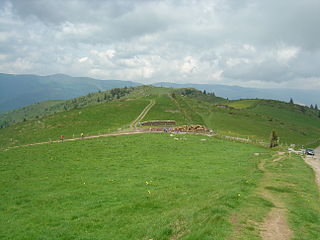
 View on the last two kilometers of the Col de Peyresourde in the climb from Armenteule. On the left side of the road a mountain pass cycling milestone can be seen.