
The Mpoko River is a river in Central African Republic It is a tributary of the Oubangui River. The river is located near Bangui, the capital of the Central African Republic.
The Mpoko River is a river in Central African Republic It is a tributary of the Oubangui River. The river is located near Bangui, the capital of the Central African Republic.
It is a small tributary off the Oubangui river, which is a tributary off the larger Congo River. [1] The Mpoko River covers 23,900 km2 of land area and 86% savanna cover. [2] It begins northwest of the capital, Bangui, and flows southeast to its confluence near Bangui. It drains a savanna dominated ecosystem. [2]
Starting in 1899, the French gave land commissions in the French Congo to 39 companies. The companies had to pay royalties to France and their main objective was the collection of rubber and ivory. One concessionary company called the "La Mpoko" was founded on July 10, 1899 with the intention of exploiting a concession that covered the basin of the Mpoko River and the other tributaries. Guilbrand Schiötz was appointed head of the company in Bimbo, in 1906 Gaston Guibet was appointed head. The chief of the Bouriki peoples came to Guibet with a complaint, armed company men were demanding more rubber in his village and committing violent crimes. In 1907 Guibet reported to the local judicial authorities the crimes committed by agents under La Mpoko. The agents would take women as hostages demanding certain rubber quotas and beat and kill many people for no apparent reason. Agents stationed there would often rape women while the men were away at work. Schiötz resigned and left Africa in 1907 right as Guibet began to start an investigation. The French Congo high commissioner Èmile Gentil asked Paris to shut La Mpoko down but was rejected and the minister in Paris claimed that legal procedures against the company's clients had to be completed first. On April 29, 1909 a persecutor in Brazzaville gave a verdict that relieved the company and clients of their crimes. Due to its bad reputation the La Mpoko concession was revoked in 1910 and the company was liquidated in February 1911. [3]
The Mpoko river was found to have high TSM levels (total suspended matter), around 78.0 mg L−1 contrasting from the low levels ranging around 0.7–16.0 mg L−1 from more rainforest dominated rivers. [4] TSM levels depict how clear the water is in a river. Due to the surrounding savanna ecosystem, the water quality of the Mpoko River is highly turbid and not recommended for drinking.

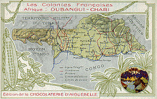
The Central African Republic (CAR), formerly known as Ubangi-Shari, is a landlocked country in Central Africa. It is bordered by Chad to the north, Sudan to the northeast, South Sudan to the east, the Democratic Republic of the Congo to the south, the Republic of the Congo to the southwest, and Cameroon to the west. Bangui is the country's capital and largest city, at the border with the Democratic Republic of the Congo. The Central African Republic covers a land area of about 620,000 square kilometres (240,000 sq mi). As of 2021, it had an estimated population of around 5.5 million. As of 2024, the Central African Republic is the scene of a civil war, which has been ongoing since 2012.
The history of the Central African Republic is roughly composed of four distinct periods. The earliest period of settlement began around 10,000 years ago when nomadic people first began to settle, farm and fish in the region. The next period began around 10,000 years prior.

The Central African Republic is a landlocked nation within the interior of the African continent. It is bordered by Cameroon, Chad, Sudan, South Sudan, the Democratic Republic of the Congo and the Republic of the Congo. Much of the country consists of flat, or rolling plateau savanna, about 1,640 feet (500 m) above sea level. In the northeast are the Fertit Hills, and there are scattered hills in the southwestern part of the country. To the northwest is the Karre Mountains, a granite plateau with an altitude of 3,750 feet (1,143 m).

The Democratic Republic of the Congo (DRC) is the largest country of sub-Saharan Africa, occupying some 2,344,858 square kilometres (905,355 sq mi). Most of the country lies within the vast hollow of the Congo River basin. The vast, low-lying central area is a plateau-shaped basin sloping toward the west, covered by tropical rainforest and criss-crossed by rivers. The forest center is surrounded by mountainous terraces in the west, plateaus merging into savannas in the south and southwest. Dense grasslands extend beyond the Congo River in the north. High mountains of the Ruwenzori Range are found on the eastern borders with Rwanda and Uganda.

The Congo River, formerly also known as the Zaire River, is the second-longest river in Africa, shorter only than the Nile, as well as the third-largest river in the world by discharge volume, following the Amazon and Ganges rivers. It is the world's deepest recorded river, with measured depths of around 220 m (720 ft). The Congo-Lualaba-Chambeshi River system has an overall length of 4,700 km (2,900 mi), which makes it the world's ninth-longest river. The Chambeshi is a tributary of the Lualaba River, and Lualaba is the name of the Congo River upstream of Boyoma Falls, extending for 1,800 km (1,100 mi).

Bangui is the capital and largest city of the Central African Republic. It was established as a French outpost in 1889 and named after its location on the northern bank of the Ubangi River ; the Ubangi itself was named from the Bobangi word for the "rapids" located beside the settlement, which marked the end of navigable water north from Brazzaville. The majority of the population of the Central African Republic lives in the western parts of the country, in Bangui and the surrounding area.
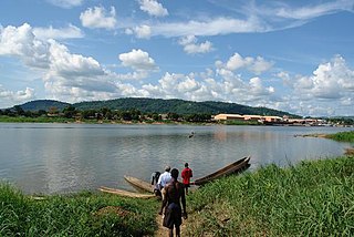
The Ubangi River, also spelled Oubangui, is the largest right-bank tributary of the Congo River in the region of Central Africa. It begins at the confluence of the Mbomou and Uele Rivers and flows west, forming the border between Central African Republic (CAR) and Democratic Republic of the Congo. Subsequently, the Ubangi bends to the southwest and passes through Bangui, the capital of the CAR, after which it flows south – forming the border between Democratic Republic of the Congo and Republic of the Congo. The Ubangi finally joins the Congo River at Liranga.

The Ogooué, also known as the Nazareth River, some 1,200 km (750 mi) long, is the principal river of Gabon in west-central Africa and the fourth largest river in Africa by volume of discharge, trailing only the Congo, Kasai and Niger. Its watershed drains nearly the entire country of Gabon, with some tributaries reaching into the Republic of the Congo, Cameroon, and Equatorial Guinea.

Barthélemy Boganda was a Central African politician and independence activist. Boganda was active prior to his country's independence, during the period when the area, part of French Equatorial Africa, was administered by France under the name of Oubangui-Chari. He served as the first Premier of the Central African Republic as an autonomous territory.
The Chari River, or Shari River, is a 1,400 kilometres (870 mi) long river, flowing in Central Africa. It is Lake Chad's main source of water.

Likouala is a department of the Republic of the Congo in the northern part of the country. It borders the departments of Cuvette and Sangha, and internationally, the Democratic Republic of the Congo and the Central African Republic. The region has an area of 66,044 km² and an estimated population of almost 360,000. The chief town is Impfondo. Principal cities and towns include Epena and Dongou.
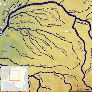
The Lulonga is a river in the Equateur province of Democratic Republic of the Congo. It is about 200 km long from its beginning at the town of Basankusu. The Lopori and the Maringa join to form the Lulonga there. The Lulonga River flows into the Congo River at the village of Lulonga.

The Congo–Ocean Railway links the Atlantic port of Pointe-Noire with Brazzaville, a distance of 502 kilometres (312 mi). It bypasses the rapids on the lower Congo River; from Brazzaville, river boats are able to ascend the Congo River and its major tributaries, including the Oubangui River to Bangui.
Carnot is a city located in the south west of the Central African Republic (CAR), in the prefecture of Mambéré.

The Congolian rainforests are a broad belt of lowland tropical moist broadleaf forests which extend across the basin of the Congo River and its tributaries in Central Africa.

The Northern Congolian forest–savanna mosaic is a forest and savanna ecoregion of central Africa. It extends east and west across central Africa, covering parts of Cameroon, Central African Republic, Democratic Republic of the Congo, South Sudan, and Uganda. It is part of the belt of transitional forest-savanna mosaic that lie between Africa's moist equatorial Guineo-Congolian forests and the tropical dry forests, savannas, and grasslands to the north and south.

Franco–Congolese relations are the current and historical relationship between the French Republic and the Republic of the Congo. France maintains an embassy in Brazzaville and a consulate in Pointe Noire. France controlled the Republic of the Congo as a colony from the 1880s until the Congo's independence in 1960. Following the collapse of communism worldwide, France has become Congo's most significant external trading partner.
The Busira River is a river in the Democratic Republic of the Congo. It is the main tributary of the Ruki River, which in turn is a tributary of the Congo River. The Busira may be seen as the upper reach of the Ruki River. It is navigable year round.
The Maringa-Lopori-Wamba Landscape (MLW) is an ecologically sensitive landscape in the Democratic Republic of the Congo within the Maringa / Lopori basin. Since 1973 a Japanese team has been researching the bonobo population near the village of Wamba, and the Luo Scientific Reserve was established in 1990. However, research was discontinued after political disorder started in 1991 followed by civil war in 1997, resuming only in the mid-2000s.

The Lobaye River is a river of the Central African Republic, a right tributary of the Ubangi River.