
The Maryland Transit Administration (MTA) is a state-operated mass transit administration in Maryland, and is part of the Maryland Department of Transportation. The MTA operates a comprehensive transit system throughout the Washington-Baltimore metropolitan area. There are 80 bus lines serving the Baltimore Metropolitan Area, along with rail services that include the Light Rail, Metro Subway, and MARC Train. In 2023, the system had a ridership of 52,922,000, or about 186,900 --> per weekday as of the first quarter of 2024.

Streetcars in Washington, D.C. transported people across the city and region from 1862 until 1962.

The Baltimore Light RailLink is a light rail system serving Baltimore, Maryland, United States, and its northern and southern suburbs. It is operated by the Maryland Transit Administration. In downtown Baltimore, it uses city streets. Outside the central portions of the city, the line is built on private rights-of-way, mostly from the defunct Northern Central Railway, Baltimore and Annapolis Railroad and Washington, Baltimore and Annapolis Electric Railway. The system had a ridership of 3,546,300, or about 14,400 per weekday, as of the first quarter of 2024.

Streetcars and interurbans operated in the Maryland suburbs of Washington, D.C., between 1890 and 1962.
LocalLink 95 is a bus route operated by the Maryland Transit Administration in Baltimore. The line currently runs from the intersection of Roland Avenue and Lake Avenue in Roland Park south to the Inner Harbor via Roland Avenue, University Parkway, Charles Street and St. Paul Street.
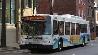
Route 27 is a bus route operated by the Maryland Transit Administration in Baltimore. The line currently runs from the Reisterstown Plaza Metro Subway Station in northwest Baltimore to Port Covington in South Baltimore through downtown. The line also serves the communities of Pimlico, Mt. Washington, Cross Keys, Hampden, and Cherry Hill, and the Greyhound bus terminal. The bus route is the successor to the 10 Roland Park, 12 Westport, and 25 Mount Washington streetcar lines.

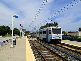
Lutherville station is a Baltimore Light Rail station located in Lutherville, Maryland. Like most suburban stations on the system, it has two side platforms serving the line's two tracks. It opened in 1992 as part of the initial operating segment.
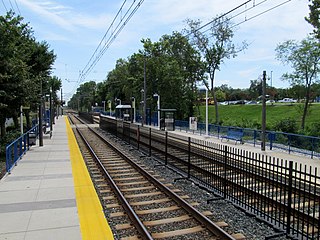
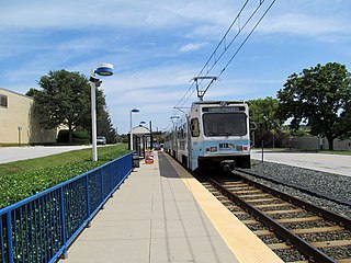
Fairgrounds station is a Baltimore Light RailLink station located adjacent to the Maryland State Fairgrounds in Timonium, Maryland. The station has two side platforms serving two tracks.

North Avenue station is a Baltimore Light Rail station located on North Avenue near the I-83 interchange in Baltimore, Maryland. The station has two island platforms serving three tracks.

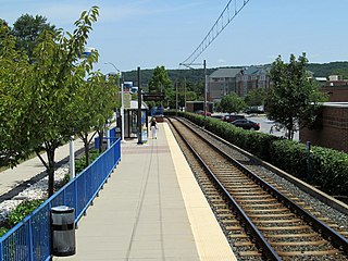
Falls Road station is a Baltimore Light Rail station in the southwest corner of Towson, Maryland, located near the Mount Washington neighborhood of Baltimore and the Bare Hills Historic District in the Jones Falls Valley. It has two side platforms serving two tracks, one in each direction. A 0.3 mile boardwalk provides access from the parking lot to neighboring Lake Roland Park.

Stadium/Federal Hill station is a Baltimore Light RailLink station in Baltimore, Maryland, located adjacent to M&T Bank Stadium. Although built to serve the stadium, it also provides access to the nearby Federal Hill and Pigtown neighborhoods.
Gilroy Road station is a Baltimore Light Rail station located in an industrial park in Hunt Valley, Maryland. It opened in 1997 as part of the system's northern extension. The station has two side platforms serving two tracks.
McCormick Road station is a Baltimore Light Rail station located in an industrial park in Hunt Valley, Maryland. It is named after the adjacent road, itself named for McCormick & Company, whose offices are nearby. The station was opened in 1997 as part of the system's northern extension. It has a single side platform serving a single track.
Pepper Road station is a Baltimore Light Rail station located in an industrial park in Hunt Valley, Maryland. The station opened in 1997 as part of the system's northern extension. It has a single side platform serving a single track.

Mt. Royal/MICA station is a Baltimore Light RailLink station in Baltimore, Maryland. It is on the northwest edge of the University of Baltimore campus and on the northern edge of the MICA campus, across Mount Royal Avenue from the site of Baltimore & Ohio Railroad's former Mount Royal Station. It opened in 1992 as part of the line's initial operating segment. The station's construction was funded by the University of Baltimore for the use of its students after the State of Maryland proposed its elimination from the plan to reduce costs.

Cultural Center station is a Baltimore Light RailLink station located along Howard Street in the Mount Vernon neighborhood of Baltimore, Maryland, adjacent to the Joseph Meyerhoff Symphony Hall. It has two side platforms served by two tracks. The station opened on April 2, 1992, as part of the first phase of the system.

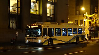
Route 58 is a bus route operated by the Maryland Transit Administration in Baltimore and its suburbs. The line's western terminus is the Reisterstown Plaza Metro Subway Station, and its eastern terminus is White Marsh Mall, though some peak hour trips make short turns in Overlea. Route 58 serves the communities of Glen, Cheswolde, Fallstaff, a large section of Northern Parkway, and a portion of Belair Road in Baltimore County.

Route 34 is a bus route operated by the Maryland Transit Administration in Baltimore and its suburbs. The line currently operates weekdays only from the Reisterstown Plaza Metro Subway Station to Stevenson University during peak hours and Greenspring Station midday.

The DC Streetcar is a surface streetcar network in Washington, D.C. As of 2017, it consists of only one line: a 2.2-mile (3.5 km) segment running in mixed traffic along H Street and Benning Road in the city's Northeast quadrant.

Cold Spring Lane station is a light rail station on the Baltimore Light Rail system. The stop is located on Cold Spring Lane near the interchange with Interstate 83. The station has two side platforms serving two tracks.

