
The Australian Capital Territory (ACT), known as the Federal Capital Territory (FCT) until 1938, is a federal territory of Australia. Canberra, the capital city of Australia, is situated within the territory. It is located in southeastern Australian mainland as an enclave completely within the state of New South Wales. Founded after Federation as the seat of government for the new nation, the territory hosts the headquarters of all important institutions of the Australian Government.

Canberra is the capital city of Australia. Founded following the federation of the colonies of Australia as the seat of government for the new nation, it is Australia's largest inland city and the eighth-largest Australian city overall. The city is located at the northern end of the Australian Capital Territory at the northern tip of the Australian Alps, the country's highest mountain range. As of June 2023, Canberra's estimated population was 466,566.
The Australian Capital Territory as of 2014 contains 46 separate protected areas with a total land area of 1,302 km2 (503 sq mi) or 55.5% of the territory's area, and which managed by Territory and Municipal Services of the ACT government:

Federal Highway is a highway in New South Wales and the Australian Capital Territory. It is a part of a motorway-standard link between Sydney and Canberra, and is also the main thoroughfare between those cities.

Barton Highway is a highway in New South Wales and the Australian Capital Territory. It connects Canberra to Hume Highway at Yass, and it is part of the route from Melbourne to Canberra. It is named in honour of Sir Edmund Barton, the first Prime Minister of Australia.

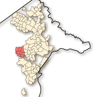
Red Hill is a suburb of Canberra, Australian Capital Territory, Australia. The suburb is named after the northernmost hill of the ridge to the west of the suburb. The ridge is a reserve and managed as part of the Canberra Nature Park. The hill is an element of the central Canberra design axis.
Weston Creek is a district in the Australian Capital Territory in Australia. The district is subdivided into divisions (suburbs), sections and blocks. The district comprises eight residential suburbs, situated to the west of the Woden Valley district and approximately 13 kilometres (8.1 mi) southwest of the Canberra City centre. Situated adjacent to the district was the large Stromlo Forest pine plantation until the forest was destroyed by bushfires in 2001 and 2003.
The suburbs of the Australian Capital Territory are organised into a hierarchy of districts, town centres, group centres, local suburbs and other industrial areas and villages. While these divisions have no formal role in the governance or administration of the city, they formed a basis for the planning and development of the city and are significant to the city's commercial and social activities.

Hume is a suburb of Canberra, and is adjacent to the District of Jerrabomberra in New South Wales.The suburb is named after the explorer Hamilton Hume and streets are named after Australian industrialists and businessmen. Hume is a light-industrial suburb and there is no significant housing development. At the 2021 census, Hume had a population of 395, up from six in 2006, as a result of the construction of the Alexander Maconochie Centre. The location of the prison has also given Hume a highly unusual gender ratio with 92.7% of the permanent population being male.
Uriarra Village is a town in the district of Coree, in the Australian Capital Territory in Australia. It is situated on the western side of the Australian Capital Territory, about 30 minutes from Canberra, established in 1928 at the foothills of the Australian Alps. A nearby area to the north of the border in New South Wales is also called Uriarra.

Coleambally is a small town in the Riverina of New South Wales, Australia, in Murrumbidgee Local Government Area.

In Australia and New Zealand, a cattle station is a large farm, the main activity of which is the rearing of cattle. The owner of a cattle station is called a grazier. The largest cattle station in the world is Anna Creek Station in South Australia, which covers an area of 23,677 square kilometres.

The geology of the Australian Capital Territory includes rocks dating from the Ordovician around 480 million years ago, whilst most rocks are from the Silurian. During the Ordovician period the region—along with most of eastern Australia—was part of the ocean floor. The area contains the Pittman Formation consisting largely of quartz-rich sandstone, siltstone and shale; the Adaminaby Beds and the Acton Shale.

Williamsdale is a town in the district of Tuggeranong, in the Australian Capital Territory in Australia. Is situated on the northwest side of the Australian Capital Territory border abutting the town of Williamsdale in the Southern Tablelands region of New South Wales, Australia. The Monaro Highway and the former Bombala railway pass through the area. A railway station saw service until 1975. The postcode is 2620.

Solar power is a major contributor to electricity supply in Australia. As of December 2023, Australia's over 3.69 million solar PV installations had a combined capacity of 34.2 GW photovoltaic (PV) solar power. In 2019, 59 solar PV projects with a combined capacity of 2,881 MW were either under construction, constructed or due to start construction having reached financial closure. Solar accounted for 12.4% of Australia's total electrical energy production in 2021.
Majura is a district in the Australian Capital Territory in Australia. With a population of 161 at the 2021 census, excluding the suburb of Pialligo, which lies to the south of Canberra Airport. Apart from Pialligo, Majura District includes Canberra Airport, three business parks and some farming but little residential development. The main shopping centre is the Majura Park Shopping Centre.
Rye Park is a town in the Southern Tablelands region of New South Wales, Australia. The town is in the Hilltops Council local government area, 305 kilometres (190 mi) south west of the state capital, Sydney and 107 kilometres (66 mi) north of the national capital, Canberra.

Energy produced in the Australian Capital Territory mainly consists of solar electricity. Electricity consumed in the Australian Capital Territory mainly comes from the national power grid through substations at Holt and Fyshwick. The ACT currently mandates that 100 percent of its electricity, will be supplied from renewable sources by 2020. The ACT has five solar farms capable of generating about 56.3 megawatts. From 1913 until the mid 1950s some power was produced from the Kingston Powerhouse, a thermal power station in Kingston.
The Mugga Lane Zoo was a privately owned zoo located on Mugga Lane in the Australian capital city of Canberra. First opened in 1979 as the Canberra Wildlife Gardens, It was the first permanent zoo in the city, predating the National Zoo & Aquarium by over a decade. In 1981 the park was rebranded as the Mugga Lane Zoo, although the Canberra Wildlife Gardens name continued to be occasionally used until 1986. Before its closure in 2002, the zoo displayed over 116 different species of animals in its 9 ha (0.035 sq mi) park. Today, the now abandoned site remains a well known location in Canberra due to its popularity with urban explorers, and as a likely source of the feral peacocks often seen around South Canberra. According to the founder, Terry Thomas, the zoo was never financially successful, in part due to difficulties experienced attaining animal permits from the Department of the Capital Territory.

