Municipalities of Honduras

Last updated

Honduras is administratively divided into 18 departments, which are subdivided into 298 municipalities (Spanish : municipios ). Municipalities are the only administrative division in Honduras that possess local government. Each municipality has its own elected mayor as opposed to the appointed governors of departments. For statistical purposes, the municipalities are further subdivided into 3731 aldeas, and those into 27969 caserios. [1] At the lowest level, some caserios are subdivided into 3336 barrios or colonias.

Contents

List of municipalities

Tegucigalpa, the capital of Honduras. Tegucigalpa.JPG
Tegucigalpa, the capital of Honduras.
San Pedro Sula. Panoramica general sps 05.jpg
San Pedro Sula.
La Ceiba. La Ceiba City Hall.jpg
La Ceiba.

  Departmental Capital

  National Capital and Departmental Capital

Name Department Population
(2013) [2]
Population
(2001) [3]
Change
(%)
Land area
(km2) [4]
Population densityFounding Date [2]
Arizona Atlántida 23,71420,670+14.7%568.81990
El Porvenir Atlántida 21,85415,444+41.5%280.31898
Esparta Atlántida 14,55917,614−17.3%398.11902
Jutiapa Atlántida 34,22430,226+13.2%533.81906
La Ceiba Atlántida 197,267140,931+40.0%636.41877
La Masica Atlántida 29,42725,509+15.4%471.01922
San Francisco Atlántida 14,55911,206+29.9%284.31903
Tela Atlántida 96,75882,499+17.3%1,196.41524
Apacilagua Choluteca 9,0659,642−6.0%213.11831
Choluteca Choluteca 152,519134,452+13.4%1,069.11535
Concepción de María Choluteca 26,87525,054+7.3%156.81852
Duyure Choluteca 3,5192,945+19.5%105.51895
El Corpus Choluteca 24,64622,213+11.0%242.21827
El Triunfo Choluteca 43,67036,705+19.0%301.51887
Marcovia Choluteca 45,63942,671+7.0%482.31882
Morolica Choluteca 5,0005,392−7.3%281.31843
Namasigue Choluteca 30,05625,606+17.4%200.91887
Orocuina Choluteca 18,31516,508+10.9%124.61646
Pespire Choluteca 23,91324,734−3.3%337.71929
San Antonio de Flores Choluteca 5,4455,695−4.4%54.01881
San Isidro Choluteca 3,6903,384+9.0%70.31876
San José Choluteca 4,3003,406+26.2%62.31861
San Marcos de Colón Choluteca 26,49421,643+22.4%582.81824
Santa Ana de Yusguare Choluteca 14,47410,755+34.6%74.31791
Balfate Colón 13,10311,677+12.2%332.31881
Bonito Oriental Colón 28,42724,801+14.6%467.51987
Iriona Colón 20,73018,585+11.5%3,986.91892
Limón Colón 13,7429,889+39.0%598.01917
Sabá Colón 29,56121,900+35.0%344.01959
Santa Fé Colón 5,4287,000−22.5%195.51881
Santa Rosa de Aguán Colón 5,3764,929+9.1%130.51892
Sonaguera Colón 43,15237,448+15.2%388.91887
Tocoa Colón 89,84961,370+46.4%848.11882
Trujillo Colón 60,55849,109+23.3%957.11525
Ajuterique Comayagua 11,3569,113+24.6%
Comayagua Comayagua 144,78596,450+50.1%
El Rosario Comayagua 28,84220,883+38.1%
Esquías Comayagua 20,51914,916+37.6%
Humuya Comayagua 1,3191,082+21.9%
La Libertad Comayagua 25,89118,542+39.6%
Lamaní Comayagua 7,0095,091+37.7%
Las Lajas Comayagua 14,3119,011+58.8%
La Trinidad Comayagua 4,5153,659+23.4%
Lejamaní Comayagua 5,6804,248+33.7%
Meámbar Comayagua 12,52210,422+20.1%
Minas de Oro Comayagua 13,12810,801+21.5%
Ojos de Agua Comayagua 10,3418,934+15.7%
San Jerónimo Comayagua 20,97915,547+34.9%
San José de Comayagua Comayagua 7,7976,085+28.1%
San José del Potrero Comayagua 6,7085,424+23.7%
San Luis Comayagua 11,1027,720+43.8%
San Sebastián Comayagua 3,6492,753+32.5%
Siguatepeque Comayagua 95,12164,704+47.0%
Taulabe Comayagua 24,23519,958+21.4%
Villa de San Antonio Comayagua 23,65817,538+34.9%
Cabañas Copán 13,7279,818+39.8%
Concepción Copán 7,7205,625+37.2%
Copán Ruinas Copán 38,10930,703+24.1%
Corquín Copán 16,40210,936+50.0%
Cucuyagua Copán 16,07311,834+35.8%
Dolores Copán 6,4205,006+28.2%
Dulce Nombre Copán 5,6714,807+18.0%
El Paraíso Copán 19,88218,397+8.1%
Florida Copán 28,33126,703+6.1%
La Jigua Copán 9,2887,915+17.3%
La Unión Copán 16,00711,536+38.8%
Nueva Arcadia Copán 40,35030,136+33.9%
San Agustín Copán 5,4983,659+50.3%
San Antonio Copán 9,7399,670+0.7%
San Jerónimo Copán 5,0204,555+10.2%
San José Copán 6,9755,397+29.2%
San Juan de Opoa Copán 9,6207,849+22.6%
San Nicolás Copán 7,5536,017+25.5%
San Pedro Copán 7,5405,168+45.9%
Santa Rita Copán 29,92724,157+23.9%
Santa Rosa de Copán Copán 61,08340,309+51.5%
Trinidad de Copán Copán 6,8655,817+18.0%
Veracruz Copán 3,2592,752+18.4%
Choloma Cortés 231,668176,789+31.0%
La Lima Cortés 62,44362,4430.0%
Omoa Cortés 45,17933,559+34.6%
Pimienta Cortés 18,55713,127+41.4%
Potrerillos Cortés 18,94518,9450.0%
Puerto Cortés Cortés 103,033103,0330.0%
San Antonio de Cortés Cortés 19,96919,9690.0%
San Francisco de Yojoa Cortés 15,09815,0980.0%
San Manuel Cortés 34,32034,3200.0%
San Pedro Sula Cortés 719,064567,713+26.7%
Santa Cruz de Yojoa Cortés 65,90165,9010.0%
Villanueva Cortés 91,61391,6130.0%
Alauca El Paraíso 7,8867,8860.0%
Danlí El Paraíso 145,024145,0240.0%
El Paraíso El Paraíso 36,54636,5460.0%
Guinope El Paraíso 7,3847,3840.0%
Jacaleapa El Paraíso 3,3963,3960.0%
Liure El Paraíso 10,08110,0810.0%
Morocelí El Paraíso 13,42413,4240.0%
Oropolí El Paraíso 5,4925,4920.0%
Potrerillos El Paraíso 3,1013,1010.0%
San Antonio de Flores El Paraíso 4,8864,8860.0%
San Lucas El Paraíso 6,9926,9920.0%
San Matías El Paraíso 4,1004,1000.0%
Soledad El Paraíso 10,13010,1300.0%
Teupasenti El Paraíso 30,29330,2930.0%
Texiguat El Paraíso 8,3008,3000.0%
Trojes El Paraíso 35,61435,6140.0%
Vado Ancho El Paraíso 3,7883,7880.0%
Yauyupe El Paraíso 1,4081,4080.0%
Yuscarán El Paraíso NA
Alubarén Francisco Morazán 5,1495,1490.0%
Cedros Francisco Morazán 19,55119,5510.0%
Curarén Francisco Morazán 17,27717,2770.0%
Distrito Central Francisco Morazán 1,157,509906,129+27.7%
El Porvenir Francisco Morazán 15,40315,4030.0%
Guaimaca Francisco Morazán 21,44921,4490.0%
La Libertad Francisco Morazán 2,7462,7460.0%
La Venta Francisco Morazán 5,8945,8940.0%
Lepaterique Francisco Morazán 13,92813,9280.0%
Maraita Francisco Morazán 5,7495,7490.0%
Marale Francisco Morazán 7,7277,7270.0%
Nueva Armenia Francisco Morazán 2,4522,4520.0%
Ojojona Francisco Morazán 8,3118,3110.0%
Orica Francisco Morazán 11,60111,6010.0%
Reitoca Francisco Morazán 9,9039,9030.0%
Sabanagrande Francisco Morazán 15,93415,9340.0%
San Antonio de Oriente Francisco Morazán 12,72112,7210.0%
San Buenaventura Francisco Morazán 1,9621,9620.0%
San Ignacio Francisco Morazán 8,0918,0910.0%
San Juan de Flores Francisco Morazán 10,82610,8260.0%
San Miguelito Francisco Morazán 1,9651,9650.0%
Santa Ana Francisco Morazán 9,0869,0860.0%
Santa Lucía Francisco Morazán 6,9816,9810.0%
Talanga Francisco Morazán 28,54328,5430.0%
Tatumbla Francisco Morazán 4,9354,9350.0%
Valle de Ángeles Francisco Morazán 11,33811,3380.0%
Vallecillo Francisco Morazán 6,9036,9030.0%
Villa de San Francisco Francisco Morazán 8,1228,1220.0%
Ahuas Gracias a Dios 6,7876,7870.0%
Brus Laguna Gracias a Dios 10,61310,6130.0%
Juan Francisco Bulnes Gracias a Dios NA
Puerto Lempira Gracias a Dios 29,80029,8000.0%
Villeda Morales Gracias a Dios NA
Wampusirpi Gracias a Dios NA
Camasca Intibucá NA
Colomoncagua Intibucá NA
Concepción Intibucá NA
Dolores Intibucá NA
Intibucá Intibucá NA
Jesús de Otoro Intibucá NA
La Esperanza Intibucá NA
Magdalena Intibucá NA
Masaguara Intibucá NA
San Antonio Intibucá NA
San Francisco de Opalaca Intibucá NA
San Isidro Intibucá NA
San Juan Intibucá NA
San Marco de Sierra Intibucá NA
San Miguelito Intibucá NA
Santa Lucía Intibucá NA
Yamaranguila Intibucá NA
Guanaja Bay Islands NA
José Santos Guardiola Bay Islands NA
Roatán Bay Islands NA
Útila Bay Islands NA
Aguaqueterique La Paz NA
Cabañas La Paz NA
Cane La Paz NA
Chinacla La Paz NA
Guajiquiro La Paz NA
La Paz La Paz NA
Lauterique La Paz NA
Marcala La Paz NA
Mercedes de Oriente La Paz NA
Opatoro La Paz NA
San Antonio del Norte La Paz NA
San José La Paz NA
San Juan La Paz NA
San Pedro de Tutule La Paz NA
Santa Ana La Paz NA
Santa Elena La Paz NA
Santa María La Paz NA
Santiago de Puringla La Paz NA
Yarula La Paz NA
Belén Lempira NA
Candelaria Lempira NA
Cololaca Lempira NA
Erandique Lempira NA
Gracias Lempira NA
Gualcince Lempira NA
Guarita Lempira NA
La Campa Lempira NA
La Iguala Lempira NA
Las Flores Lempira NA
La Unión Lempira NA
La Virtud Lempira NA
Lepaera Lempira NA
Mapulaca Lempira NA
Piraera Lempira NA
San Andrés Lempira NA
San Francisco Lempira NA
San Juan Guarita Lempira NA
San Manuel Colohete Lempira NA
San Marcos de Caiquín Lempira NA
San Rafael Lempira NA
San Sebastian Lempira NA
Santa Cruz Lempira NA
Talgua Lempira NA
Tambla Lempira NA
Tomalá Lempira NA
Valladolid Lempira NA
Virginia Lempira NA
Belén Gualcho Ocotepeque NA
Concepción Ocotepeque NA
Dolores Merendon Ocotepeque NA
Fraternidad Ocotepeque NA
La Encarnación Ocotepeque NA
La Labor Ocotepeque NA
Lucerna Ocotepeque NA
Mercedes Ocotepeque NA
Ocotepeque Ocotepeque NA
San Fernando Ocotepeque NA
San Francisco del Valle Ocotepeque NA
San Jorge Ocotepeque NA
San Marcos Ocotepeque NA
Santa Fé Ocotepeque NA
Sensenti Ocotepeque NA
Sinuapa Ocotepeque NA
Campamento Olancho NA
Catacamas Olancho NA
Concordia Olancho NA
Dulce Nombre de Culmí Olancho NA
El Rosario Olancho NA
Esquipulas del Norte Olancho NA
Gualaco Olancho NA
Guarizama Olancho NA
Guata Olancho NA
Guayape Olancho NA
Jano Olancho NA
Juticalpa Olancho NA
La Unión Olancho NA
Mangulile Olancho NA
Manto Olancho NA
Patuca Olancho NA
Salamá Olancho NA
San Esteban Olancho NA
San Francisco de Becerra Olancho NA
San Francisco de la Paz Olancho NA
Santa Maria del Real Olancho NA
Silca Olancho NA
Yocón Olancho NA
Arada Santa Bárbara NA
Atima Santa Bárbara NA
Azacualpa Santa Bárbara NA
Ceguaca Santa Bárbara NA
Chinda Santa Bárbara NA
Concepción del Norte Santa Bárbara NA
Concepción del Sur Santa Bárbara NA
El Nispero Santa Bárbara NA
Gualala Santa Bárbara NA
Ilama Santa Bárbara NA
Las Vegas Santa Bárbara NA
Macuelizo Santa Bárbara NA
Naranjito Santa Bárbara NA
Nueva Frontera Santa Bárbara NA
Nuevo Celilac Santa Bárbara NA
Petoa Santa Bárbara NA
Protección Santa Bárbara NA
Quimistán Santa Bárbara NA
San Francisco de Ojuera Santa Bárbara NA
San José de Colinas Santa Bárbara NA
San Luis Santa Bárbara NA
San Marcos Santa Bárbara NA
San Nicolás Santa Bárbara NA
San Pedro Zacapa Santa Bárbara NA
Santa Bárbara Santa Bárbara NA
Santa Rita Santa Bárbara NA
San Vicente Centenario Santa Bárbara NA
Trinidad Santa Bárbara NA
Alianza Valle NA
Amapala Valle NA
Aramecina Valle NA
Caridad Valle NA
Goascorán Valle NA
Langue Valle NA
Nacaome Valle NA
San Francisco de Coray Valle NA
San Lorenzo Valle NA
Arenal Yoro 5,1395,1390.0%169.31848
El Negrito Yoro 37,09537,0950.0%514.21843
El Progreso Yoro 188,366157,188+19.8%536.71850
Jocón Yoro 9,5917,743+23.9%345.81791
Morazán Yoro 40,40234,052+18.6%518.31843
Olanchito Yoro 104,60983,749+24.9%2,028.21530
Santa Rita Yoro 20,30118,666+8.8%149.01684
Sulaco Yoro 17,50913,858+26.3%236.71654
Victoria Yoro 33,01926,678+23.8%795.81896
Yorito Yoro 18,82313,412+40.3%209.11889
Yoro Yoro 86,66567,834+27.8%2,277.21852
Honduras 8,303,7716,535,344+27.1%
Municipalities of Honduras Mapa de Municipios de Honduras.svg
Municipalities of Honduras

See also

Related Research Articles

<span class="mw-page-title-main">Departments of Honduras</span> First-level administrative division of Honduras

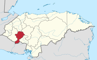
Honduras is divided into 18 departments. Each department is headed by a governor, who is appointed by the President of Honduras. The governor represents the executive branch in the region in addition to acting as intermediary between municipalities and various national authorities; resolves issues arising between municipalities; oversees the penitentiaries and prisons in his department; and regularly works with the various Secretaries of State that form the President's Cabinet. To be eligible for appointment as a governor, the individual must: a) live for five consecutive years in the department; b) be Honduran; c) be older than 18 years of age and; d) know how to read and write.

<span class="mw-page-title-main">Intibucá Department</span> Department in Honduras

Intibucá is one of the 18 departments in the Republic of Honduras. Intibucá covers a total surface area of 1,186.1 square miles (3,072 km2). Its capital is the city of La Esperanza, in the municipality of La Esperanza.

<span class="mw-page-title-main">El Paraíso Department</span> Department in Honduras

El Paraíso is one of the 18 departments (departamentos) into which Honduras is divided.

<span class="mw-page-title-main">Municipalities of Chiapas</span>

Chiapas is a state in Southwest Mexico. According to the 2020 Mexican census, it has the eighth largest population of all states with 5,543,828 inhabitants and the 10th largest by land area spanning 73,560.47 square kilometres (28,401.86 sq mi). Chiapas is officially divided into 124 municipalities, although the establishment of municipal authorities in Belisario Domínguez was suspended in 2015 pending the resolution of a territorial dispute between Chiapas and the neighbouring state of Oaxaca. In 2021, the Mexican Supreme Court resolved this dispute in Oaxaca's favour, and annulled the 2011 decree that had created Belisario Domínguez.

San Juan de Manapiare is a town in the southern Venezuelan state of Amazonas. This town is the shire town of the Manapiare Municipality and, according to the 2001 Venezuelan census, the municipality has a population of 991.

<span class="mw-page-title-main">Apacilagua</span> Municipality in Choluteca, Honduras

Apacilagua is a small town and municipality in the Honduran department of Choluteca. It is situated 29.3 kilometres (18.2 mi) by road to the northeast of the town of Choluteca, in the northern mid part of the province, not far from the border with the El Paraíso Department. The small town of Apacilagua lies on the Choluteca River along the RN85 road, and contains the Iglesia Catolica Apacilagua, a Catholic church. The municipality covers an area of 213.1 square kilometres (82.3 sq mi), and contains 8 villages and 149 hamlets. As of 2015 it had a population of 9,075 people.

El Corpus is a municipality in the Honduran department of Choluteca.

Morazán is a town, with a population of 22,240, and a municipality in the Honduran department of Yoro. This political division of 50,930 people is in the north, located between the city of Yoro and the municipality of El Negrito, north of the Nico Pijol National Park.

<span class="mw-page-title-main">La Unión, Olancho</span> Municipality in Olancho, Honduras

La Unión is a municipality in the northwest of the Olancho Department of Honduras.

<span class="mw-page-title-main">Limón, Honduras</span> Municipality in Colón, Honduras

Limón is a municipality in the department of Colón in Honduras.

<span class="mw-page-title-main">San Antonio del Táchira</span> Place in Táchira, Venezuela

San Antonio del Táchira is a city in the Venezuelan Andean state of Táchira. The busy highway across the Simón Bolívar International Bridge linking the cities of Cúcuta, Colombia, and San Cristóbal, Venezuela, passes through San Antonio del Táchira, making it an important gateway between the two nations. This city is the shire town of the Municipio Bolívar de Táchira and, according to the 2001 Venezuelan census, the municipality has a population of 48,171.

<span class="mw-page-title-main">Cantons of Costa Rica</span> Political subdivision of Costa Rica

Costa Rica is administratively divided into seven provinces which are subdivided into 84 cantons, and these are further subdivided into districts. Cantons are the only administrative division in Costa Rica that possess local government in the form of municipalities. Each municipality has its own mayor and several representatives, all of them chosen via municipal elections every four years.

<span class="mw-page-title-main">Andrés Eloy Blanco Municipality, Lara</span> Municipality in Lara, Venezuela

The Andrés Eloy Blanco Municipality is one of the nine municipalities (municipios) that makes up the Venezuelan state of Lara and, according to a 2007 population estimate by the National Institute of Statistics of Venezuela, the municipality has a population of 49,812. The town of Sanare is the county seat of the Andrés Eloy Blanco Municipality. The municipality is one of several in Venezuela named "Andrés Eloy Blanco Municipality" in honour of Venezuelan poet Andrés Eloy Blanco.

<span class="mw-page-title-main">Jiménez Municipality, Lara</span> Municipality in Lara, Venezuela

The Jiménez Municipality is one of the nine municipalities (municipios) that makes up the Venezuelan state of Lara and, according to a 2007 population estimate by the National Institute of Statistics of Venezuela, the municipality has a population of 97,524. The town of Quíbor is the shire town of the Jiménez Municipality.

<span class="mw-page-title-main">Morán Municipality</span> Municipality in Lara, Venezuela

The Morán Municipality is one of the nine municipalities (municipios) that makes up the Venezuelan state of Lara and, according to a 2007 population estimate by the National Institute of Statistics of Venezuela, the municipality has a population of 128,674. The town of El Tocuyo is the shire town of the Morán Municipality.

<span class="mw-page-title-main">Urdaneta Municipality, Lara</span> Municipality in Lara, Venezuela

Urdaneta is one of the nine municipalities (municipios) that make up the Venezuelan state of Lara and, according to a 2007 population estimate by the National Institute of Statistics of Venezuela, the municipality has a population of 63,213. The town of Siquisique is the municipal seat of the Urdaneta Municipality. The municipality is one of several in Venezuela named "Urdaneta Municipality" in honour of Venezuelan independence hero Rafael Urdaneta.

<span class="mw-page-title-main">Tegucigalpa</span> Capital and largest city of Honduras

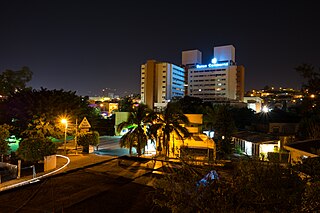
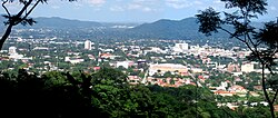
Tegucigalpa —formally Tegucigalpa, Municipality of the Central District, and colloquially referred to as Tegus or Teguz—is the capital and largest city of Honduras along with its sister city, Comayagüela.

<span class="mw-page-title-main">Bolívar Municipality, Sucre</span> Municipality in Sucre, Venezuela

Bolívar is a municipality of Sucre, Venezuela. The capital is Marigüitar. It was founded in 1713 after many years of missionary work taking place in the area.

<span class="mw-page-title-main">Intibucá, Intibucá</span> Municipality in Intibucá, Honduras

Intibucá is a city, with a population of 28,220, and a municipality in the department of Intibucá, Honduras. The urban area of Intibucá is an important transit and commercial site in the South-West region of Honduras. Located 1,850 meters above sea level, Intibucá has a cool and often foggy climate, hence the nickname "La ciudad del manto blanco". Potato production, celebrated by the annual Festival de la Papa, is the principal basis of the economy for the municipality.

References

  1. "Archived copy". Archived from the original on 2007-06-09. Retrieved 2007-06-09.{{cite web}}: CS1 maint: archived copy as title (link)
  2. 1 2 "Archived copy". Archived from the original on 2020-09-18. Retrieved 2018-07-23.{{cite web}}: CS1 maint: archived copy as title (link)
  3. "10. Poblacion por sexo y viviendas particulares por estado de ocupación" (XLSX). Ine.gob.hn. Retrieved 15 October 2017.
  4. "Index of /images/Productos ine/censo/Censo 2013/298 Municipios" (PDF). Ine.gob.hn. Retrieved 15 October 2017.