National Marine Sanctuary of American Samoa

Last updated
National Marine Sanctuary of American Samoa
(Formerly the Fagatele Bay National Marine Sanctuary) [1]
NMS of American Samoa map.jpg
Map of the National Marine Sanctuary of American Samoa
Location American Samoa:
Coordinates 14°21′54″S170°45′54″W / 14.365°S 170.765°W / -14.365; -170.765 [lower-alpha 1]
Area13,581 sq mi (35,170 km2)
Established1986, [lower-alpha 2] expanded 2012
Governing body National Oceanic and Atmospheric Administration
americansamoa.noaa.gov/welcome.html

The National Marine Sanctuary of American Samoa (formerly the Fagatele Bay National Marine Sanctuary [1] ) is a federally-designated underwater area protected by the National Oceanic and Atmospheric Administration's (NOAA) Office of National Marine Sanctuaries. This sanctuary is the largest and most remote in the National Marine Sanctuary system. [2] Spanning 13,581 sq mi, [2] [3] it is thought to be home to the greatest biodiversity of aquatic species of all themarine sanctuaries. [2] [4] [5] Among them are expansive coral reefs, including some of the oldest Porites coral heads on earth, deep-water reefs, hydrothermal vent communities, and rare archeological resources. [1] It was established in 1986, and then expanded and renamed in 2012.

Contents

The American Samoa archipelago is located in the mid-south Pacific Ocean, halfway between Hawaii and New Zealand. [6] It is the only American Territory south of the equator. [6] The Park has one visitor center in Tutuila, known as Tauese P.F. Sunia Ocean Center. [7] [8] There are exhibits for all ages, and it is open year-round. [8]

Description

The National Marine Sanctuary of American Samoa comprises six protected areas: Fagatele Bay and Fagalua/Fogama`a (the bay east of Fagatele) on the island of Tutuila, areas at Aunuʻu, Taʻū, Swains Island, and Rose Atoll, after major additions in protected areas during 2012. [9] It is the only true tropical reef within the National Marine Sanctuary program, and is also the most remote. [10] [5]

The Fagatele Bay portion of the sanctuary is completely contained in the 0.25 square miles (0.65 km2) of the bay formed by an eroded volcanic crater . The land surrounding the bay resides in the hands of the families who have lived near the bay's slopes for thousands of years. Fortunately, there is little development in the watershed and the one reliable stream that empties near the beach runs clear and clean.

The fringing coral reef ecosystem nestled within Fagatele Bay is a vibrant tropical marine ecosystem, filled with all sorts of brightly colored tropical fish, including parrot fish, damselfish and butterfly fish, as well as other sea creatures like lobster, crabs, sharks and octopus. From June to September, southern humpback whales migrate north from Antarctica to calve and court in Samoan waters. Visitors can hear courting males sing whale songs, which the whales may be using to attract mates. Several species of dolphin and threatened and endangered species of sea turtles, such as the hawksbill and green sea turtle, are frequently seen swimming in the bay. Recreational activities such as diving, snorkeling, and fishing can be enjoyed at the sanctuary. [4]

Fagatele Bay as a Marine Sanctuary

Map of Fagatele Bay Fagatele Bay NMS map.jpg
Map of Fagatele Bay
Fagatele Bay, with view on Steps Point, the most southerly point of Samoa (excluding Rose Atoll, also of the US). The ship is NOAAS Hi'ialakai Ship1434 - Flickr - NOAA Photo Library.jpg
Fagatele Bay, with view on Steps Point, the most southerly point of Samoa (excluding Rose Atoll, also of the US). The ship is NOAAS Hi'ialakai

Fagatele Bay National Marine Sanctuary was designated in 1986 [11] in response to a proposal from the American Samoa Government to the National Marine Sanctuary Program. The National Marine Sanctuary Program supports research in all of its 14 sites. Research plays a role in management by supplying information needed to make resource protection decisions based on hard scientific data. Fagatele Bay's most important research project spans over a decade. In the late 1970s, millions of Acanthaster planci or crown-of-thorns starfish (alamea), a coral-eating animal, ate their way through Tutuila's reefs. More than 90 percent of all the living corals were destroyed. [10] At the time, Fagatele Bay was not a National Marine Sanctuary, but this disaster propelled the decision for the site's designation.

The National Marine Sanctuary Program protects and preserves nature and local culture. The program is found in areas of special significance such as the oceans and Great Lakes of the United States. There are 14 sanctuaries in the program ranging from Stellwagen Bank off Cape Cod to the Channel Islands in southern California. All manage their precious resources through a combination of education, research, long-term monitoring, regulation and enforcement.

Many different types of fish call this reef home, and many biologists and marine researchers attempt to cooperate with the local government in an effort to find new species within the local waters. Many new species have been found, but as it is a marine sanctuary, fish or other marine animals cannot be removed from the ecosystem. Scientists, headed up by Dr. Charles Birkenland, used the starfish's destruction as a focus of their long-term research: to follow the recovery of a coral reef. Because corals grow slowly, the research team chose a multi-year cycle of data collection. Beginning in 1985, and again in 1988, 1995, 1998, 2001 and 2004, the team amassed information on coral, fishes, invertebrates and marine plants. This database is unique for Samoa and the study is one of the few long-running surveys of its type in the world

Climate Change

An increase in greenhouse gas emissions have caused a rise in global temperatures. This phenomenon, known as global warming or climate change, is beginning to impact Earth's most treasured natural spaces, and the Samoan Islands are among the most vulnerable regions. [12] This rise in CO2 and temperature causes an imbalance in the Samoan reef ecosystem in a myriad of ways, which will be described below.

Ocean Acidification

Since 1750, the acidity of the ocean has increased by 30%. [13] An increase in ocean acidification destabilizes Samoan reefs by impacting crustose corraline algae, [13] a calcareous species that consolidates and cements reefs together. [14] A reduction in coral calcification impairs coral growth and density, increasing vulnerability to erosion and damage. [15] The increase in acidification also makes it difficult for clams in all stages of life to grow their shells, and for the larvae of corral reef fish to grow, survive, and make it back to the reef. [13] It is projected that by 2060, the aragonite (CaCO3) saturation state that is crucial to coral growth will fall below the optimal threshold of 4.0 to 3.5, and continue deteriorating in the future. [12] [13]

Rising Water Temperatures

The oceans absorb much of the heat caused due to increase in global temperature. [13] Waters in American Samoa have risen 1.8F in the past 30 years, and are projected to increase 4.7F by 2090. [12] [13]

Extreme temperature events, also known as heatwaves, have also increased in frequency. [13] Coupled with the rise in ocean temperature, these heatwaves cause coral bleaching events, wherein symbiotic algae are expelled from the coral, causing the corals to appear white. [13] These algae provide food and process waste from the corals, hence are extremely essential to their survival. [13] Six mass bleaching events have occurred from 1994 to 2020, with the 2015 event causing the most damage. [16] [13] These events are projected to become more frequent and intense in the future. [13] It is estimated that the reefs of the American Samoa could experience yearly bleaching by the year 2040. [13] [15]

By the year 2115, under extreme warming, it is projected that water temperatures in this region may be too high for species currently living in the reefs. [13] Due to the isolation of the Samoan reefs, species may not be able to find another suitable habitat. [13] Warming temperatures may also worsen coral diseases and favor invasive species, such as the outbreaks of the crown-of-thorns sea star, a predator of the coral. [13] Algal blooms will also become more expansive and longer-lasting. [12] [13] Some of these blooms may also be Harmful Algal Blooms (HABs) and become toxic to life around it. [12] [13]

Changing Weather Patterns and Storms

In the American Samoa, climate change is estimated to increase rainfall by about 10% by 2100, [13] while extreme precipitation events are also projected to increase in frequency. [13] These extreme events cause large amounts of sediment runoff, which bury corals, suffocating and killing them. [13] [15] This sediment also clouds up the water, making photosynthesis challenging. [13] Nitrogen from fertilizers increase coral disease and contribute to coral bleaching. [12] [15] [13]

Tropical cyclones drive harsh winds and towering waves that cause damage to coral systems, sometimes causing persistent decrease in coral cover. [13] These storms are expected to increase in intensity, but decrease in frequency over the next 70 years. [12] [13]

Actions Being Taken

The NOAA Ocean Acidification Program placed a very scientifically powerful buoy in Fagatele Bay in May 2019. [13] This buoy records real-time values of water temperature, acidity, and other relevant parameters, that can then be used to assess trends. [13] NOAA also tackles non-climate stressors that can make the reefs more resilient as a whole. [13] The population of crown-of-thorns sea star, a natural predator of corals, is closely monitored and controlled to prevent outbreaks. [13] The sea stars are injected with ox bile that painlessly kills them and does not harm the rest of the ecosystem. [13] A coral nursery project was also piloted in 2020. [13] In the future, corals from the nursery could be used to restore reefs after devastation due to weather or other events. [13]

Education

The sanctuary sponsors education programs, such as the EnviroDiscoveries Camp, which is an outdoor activity and learning camp for 8- to 12-year-olds. Scientific programs include a continuing resource assessment survey, begun in 1985, and coral reef monitoring. Sanctuary regulations prohibit taking invertebrates and sea turtles, as well as historical artifacts. Only traditional fishing methods are permitted in the inner bay.

The sanctuary makes a special effort to work with the American Samoan community with outreach programs for all ages. The sanctuary co-sponsors a summer environmental education program for 8- to 12-year-old children. These programs explore the marine life in the bay, including ancient reef-dwellers and solar-powered clams, teaching ways to protect the resources there. Samoan cultural events and general community outreach/education programs are also run year-round. [17]

The sanctuary also provides guided tours of the area, and allows any student to come on field-trips, for which they provide educational guides. They also emphasize the cultural aspects of the reefs and the wildlife, so as to combine traditional culture with the scientific knowledge students learn in school. The sanctuary also aids local education by organizing projects for the High Schoolers on the island, to further reinforce the necessity of the National Marine Sanctuary.

Big Momma

Big Momma with a diver in the background Big Momma.jpg
Big Momma with a diver in the background

Also known as Big Mama and Fale Bommie, [18] Big Momma is the biggest known coral on Earth. [19] It is located in the Valley of Giants in the National Marine Sanctuary of American Samoa. [20] It is 21-foot (6.4 m) tall, and its circumference is 134 feet (41 m). It is over 500 years old. Its scientific name is Porites lobata . [20]

Animals

Staff

Nancy Daschbach is Fagatele Bay's on-site manager. Americorps volunteers assist the outreach program. Staff members are American Samoa Government employees based in Pago Pago, American Samoa and operate through a cooperative agreement between the National Oceanic and Atmospheric Administration and American Samoa's Economic and Development Planning Office, as well as the National Marine Sanctuary Association (NMSA). The volunteers typically work for 3 months and then take the rest of the time off, but a volunteer can work enough to become a paid worker for the NMSA or even take a Manager position at another Marine Sanctuary.[ citation needed ]

Notes

  1. Coordinates at Fagatele Bay.
  2. As Fagatele Bay National Marine Sanctuary.

Related Research Articles

<span class="mw-page-title-main">Coral bleaching</span> Phenomenon where coral expel algae tissue

Coral bleaching is the process when corals become white due to loss of symbiotic algae and photosynthetic pigments. This loss of pigment can be caused by various stressors, such as changes in temperature, light, or nutrients. Bleaching occurs when coral polyps expel the zooxanthellae that live inside their tissue, causing the coral to turn white. The zooxanthellae are photosynthetic, and as the water temperature rises, they begin to produce reactive oxygen species. This is toxic to the coral, so the coral expels the zooxanthellae. Since the zooxanthellae produce the majority of coral colouration, the coral tissue becomes transparent, revealing the coral skeleton made of calcium carbonate. Most bleached corals appear bright white, but some are blue, yellow, or pink due to pigment proteins in the coral.

<span class="mw-page-title-main">Channel Islands National Marine Sanctuary</span> Marine sanctuary in the Pacific Coast of Southern California

The Channel Islands National Marine Sanctuary is a sanctuary off the coast of Santa Barbara and Ventura counties in Southern California 350 miles south of San Francisco and 95 miles north of Los Angeles. It was designated in 1980 by the National Oceanic and Atmospheric Administration.

The National Ocean Service (NOS) is an office within the U.S. Department of Commerce, National Oceanic and Atmospheric Administration (NOAA). It is responsible for preserving and enhancing the nation's coastal resources and ecosystems along approximately 95,000 miles (153,000 km) of shoreline, that is bordering 3,500,000 square miles (9,100,000 km2) of coastal, Great Lakes and ocean waters. Its mission is to "provide science-based solutions through collaborative partnerships to address evolving economic, environmental, and social pressures on our oceans and coasts." The office works with partnered agencies to ensure that ocean and coastal areas are safe, healthy, and productive. It`s projects focus on working to ensure safe and efficient marine transportation, promoting the protection of coastal communities, conserving marine and coastal places. It employs 1,700 scientists, natural resource managers, and specialists in many different fields. The National Ocean Service was previously known as the National Ocean Survey until it was renamed in 1983.

<span class="mw-page-title-main">National Marine Sanctuary</span> Zone in US waters designated for special protection

A U.S. National Marine Sanctuary is a zone within United States waters where the marine environment enjoys special protection. The program was established in 1972 by the Marine Protection, Research, and Sanctuaries Act and is currently administered by the National Ocean Service through the National Marine Sanctuaries Act (NMSA).

<span class="mw-page-title-main">Flower Garden Banks National Marine Sanctuary</span>

The Flower Garden Banks National Marine Sanctuary (FGBNMS) is a United States National Marine Sanctuary located 100 nautical miles (190 km) offshore of Galveston, Texas, in the northwestern Gulf of Mexico. It contains the northernmost coral reefs in the United States.

<span class="mw-page-title-main">Florida Keys National Marine Sanctuary</span> Marine protected area in Florida, US

The Florida Keys National Marine Sanctuary is a U.S. National Marine Sanctuary in the Florida Keys. It includes the Florida Reef, the only barrier coral reef in North America and the third-largest coral barrier reef in the world. It also has extensive mangrove forest and seagrass fields. The Florida Keys National Marine Sanctuary, designated in 1990, is the ninth national marine sanctuary to be established in a system that comprises 13 sanctuaries and two marine national monuments. The Florida Keys National Marine Sanctuary protects approximately 2,900 square nautical miles of coastal and ocean waters from the estuarine waters of south Florida along the Florida Keys archipelago, encompassing more than 1,700 islands, out to the Dry Tortugas National Park, reaching into the Atlantic Ocean, Florida Bay and the Gulf of Mexico.

<span class="mw-page-title-main">Tutuila</span> Largest island in American Samoa

Tutuila is the largest and most populous island of American Samoa and is part of the archipelago of the Samoan Islands. It is the third largest island in the Samoan Islands chain of the Central Pacific. It is located roughly 4,000 kilometers (2,500 mi) northeast of Brisbane, Australia and lies over 1,200 kilometers (750 mi) to the northeast of Fiji. It contains a large, natural harbor, Pago Pago Harbor, where Pago Pago, the capital of American Samoa, is situated. Pago Pago International Airport is also located on Tutuila. The island's land expanse is about 68% of the total land area of American Samoa. With 56,000 inhabitants, it is also home to 95% of the population of American Samoa. The island has six terrestrial and three marine ecosystems.

<span class="mw-page-title-main">Marine conservation</span> Protection and preservation of saltwater ecosystems

Marine conservation, also known as ocean conservation, is the protection and preservation of ecosystems in oceans and seas through planned management in order to prevent the over-exploitation of these marine resources. Marine conservation is informed by the study of marine plants and animal resources and ecosystem functions and is driven by response to the manifested negative effects seen in the environment such as species loss, habitat degradation and changes in ecosystem functions and focuses on limiting human-caused damage to marine ecosystems, restoring damaged marine ecosystems, and preserving vulnerable species and ecosystems of the marine life. Marine conservation is a relatively new discipline which has developed as a response to biological issues such as extinction and marine habitats change.

<span class="mw-page-title-main">Rose Atoll Marine National Monument</span>

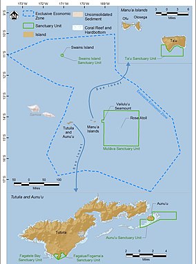
Rose Atoll Marine National Monument is a United States National Monument in the South Pacific Ocean, covering 8,571,633 acres and encompassing the Rose Atoll National Wildlife Refuge, which was established in 1973 with 39,066 acres, only 20 acres (8.1 ha) of which is emergent. The monument's marine areas are likely to also be incorporated in the National Marine Sanctuary of American Samoa.

<span class="mw-page-title-main">Marine ecosystem</span> Ecosystem in saltwater environment

Marine ecosystems are the largest of Earth's aquatic ecosystems and exist in waters that have a high salt content. These systems contrast with freshwater ecosystems, which have a lower salt content. Marine waters cover more than 70% of the surface of the Earth and account for more than 97% of Earth's water supply and 90% of habitable space on Earth. Seawater has an average salinity of 35 parts per thousand of water. Actual salinity varies among different marine ecosystems. Marine ecosystems can be divided into many zones depending upon water depth and shoreline features. The oceanic zone is the vast open part of the ocean where animals such as whales, sharks, and tuna live. The benthic zone consists of substrates below water where many invertebrates live. The intertidal zone is the area between high and low tides. Other near-shore (neritic) zones can include mudflats, seagrass meadows, mangroves, rocky intertidal systems, salt marshes, coral reefs, lagoons. In the deep water, hydrothermal vents may occur where chemosynthetic sulfur bacteria form the base of the food web.

<span class="mw-page-title-main">Papahānaumokuākea Marine National Monument</span> Protected region of ocean and islands

The Papahānaumokuākea Marine National Monument (PMNM) is a World Heritage listed U.S. National Monument encompassing 583,000 square miles (1,510,000 km2) of ocean waters, including ten islands and atolls of the Northwestern Hawaiian Islands. It was created in June 2006 with 140,000 square miles (360,000 km2) and expanded in August 2016 by moving its border to the limit of the exclusive economic zone, making it one of the world's largest protected areas. It is internationally known for its cultural and natural values as follows:

The area has deep cosmological and traditional significance for living Native Hawaiian culture, as an ancestral environment, as an embodiment of the Hawaiian concept of kinship between people and the natural world, and as the place where it is believed that life originates and to where the spirits return after death. On two of the islands, Nihoa and Mokumanamana, there are archaeological remains relating to pre-European settlement and use. Much of the monument is made up of pelagic and deepwater habitats, with notable features such as seamounts and submerged banks, extensive coral reefs and lagoons.

<span class="mw-page-title-main">Ocean Conservancy</span> Nonprofit environmental advocacy group

Ocean Conservancy is a nonprofit environmental advocacy group based in Washington, D.C., United States. The organization seeks to promote healthy and diverse ocean ecosystems, prevent marine pollution, climate change and advocates against practices that threaten oceanic and human life.

<span class="mw-page-title-main">Wild fisheries</span> Area containing fish that are harvested commercially

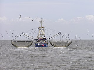
A wild fishery is a natural body of water with a sizeable free-ranging fish or other aquatic animal population that can be harvested for its commercial value. Wild fisheries can be marine (saltwater) or lacustrine/riverine (freshwater), and rely heavily on the carrying capacity of the local aquatic ecosystem.

<span class="mw-page-title-main">Watamu Marine National Park</span> Marine park in Kenya

Watamu Marine National Park and Reserve is located in Kenya. Established in 1968, it was one of Kenya's first marine parks. It is located about 90 miles (140 km) north of Mombasa, Kenya's second largest city. Its coral gardens are 300 metres (980 ft) from the shore and are home to approximately 600 species of fish, 110 species of stony coral and countless invertebrates, crustaceans and molluscs. Water temperature varies from 20 degrees Celsius to 30 degrees Celsius. The park was designated as a biosphere reserve in 1979.

<span class="mw-page-title-main">Florida Reef</span> Coral barrier reef along the Florida Keys

The Florida Reef is the only living coral barrier reef in the continental United States. It lies a few miles seaward of the Florida Keys, is about 4 miles wide and extends 270 km (170 mi) from Fowey Rocks just east of Soldier Key to just south of the Marquesas Keys. The barrier reef tract forms a great arc, concentric with the Florida Keys, with the northern end, in Biscayne National Park, oriented north-south and the western end, south of the Marquesas Keys, oriented east-west. The rest of the reef outside Biscayne National Park lies within John Pennekamp Coral Reef State Park and the Florida Keys National Marine Sanctuary. Isolated coral patch reefs occur northward from Biscayne National Park as far north as Stuart, in Martin County. Coral reefs are also found in Dry Tortugas National Park west of the Marquesas Keys. There are more than 6,000 individual reefs in the system. The reefs are 5,000 to 7,000 years old, having developed since sea levels rose following the Wisconsinan glaciation.

<span class="mw-page-title-main">Environmental issues with coral reefs</span> Factors which adversely affect tropical coral reefs

Human activities have substantial impact on coral reefs, contributing to their worldwide decline.[1] Damaging activities encompass coral mining, pollution, overfishing, blast fishing, as well as the excavation of canals and access points to islands and bays. Additional threats comprise disease, destructive fishing practices, and the warming of oceans.[2] Furthermore, the ocean's function as a carbon dioxide sink, alterations in the atmosphere, ultraviolet light, ocean acidification, viral infections, the repercussions of dust storms transporting agents to distant reefs, pollutants, and algal blooms represent some of the factors exerting influence on coral reefs. Importantly, the jeopardy faced by coral reefs extends far beyond coastal regions. The ramifications of climate change, notably global warming, induce an elevation in ocean temperatures that triggers coral bleaching—a potentially lethal phenomenon for coral ecosystems.

<span class="mw-page-title-main">Western Pacific Regional Fishery Management Council</span>

The Western Pacific Regional Fishery Management Council (WPRFMC) is one of eight regional councils established under the Magnuson-Stevens Fishery Conservation and Management Act (MSA) in 1976 to manage offshore fisheries. The WPRFMC's jurisdiction includes the US exclusive economic zone (EEZ) waters around the State of Hawaii; US Territories of American Samoa and Guam; the Commonwealth of the Northern Mariana Islands (CNMI); and the US Pacific remote island areas of Johnston, Midway, Palmyra and Wake Atolls; Baker, Howland and Jarvis Islands; and Kingman Reef. This area of nearly 1.5 million square miles is the size of the continental United States and constitutes about half of the entire US EEZ. It spans both sides of the equator and both sides of the dateline. The WPRFMC also manages domestic fisheries based in the US Pacific Islands that operate on the high seas.

<i>Porites cylindrica</i> Species of coral

Porites cylindrica, commonly known as hump coral, is a stony coral belonging to the subclass Hexacorallia in the class Anthozoa. Hexacorallia differ from other subclasses in that they have 6 or fewer axes of symmetry. Members of this class possess colonial polyps which can be reef-building, secreting a calcium carbonate skeleton. They are dominant in both inshore reefs and midshelf reefs.

<span class="mw-page-title-main">Coral Reef Conservation Program</span>

Coral Reef Conservation Program (CRCP) is a partnership between National Oceanic and Atmospheric Administration (NOAA) agencies, established in 2000. The program is a multidisciplinary approach, initiated by the NOAA, to managing and understanding coral reef ecosystems through research and the publication of data to support relevant partners involved in coral reef restoration.

The East African coral coast is a marine ecoregion along the eastern coast of Africa. It extends along the coasts of Kenya, Tanzania, and northern Mozambique, from Lamu in Kenya to Angoche in Mozambique. It adjoins the Northern Monsoon Current Coast ecoregion to the north, and the Bight of Sofala/Swamp Coast ecoregion to the south.

References

  1. 1 2 3 http://americansamoa.noaa.gov National Marine Sanctuary of American Samoa. NOAA.gov. Retrieved 1 January 2018.
  2. 1 2 3 "NATIONAL MARINE SANCTUARY OF AMERICAN SAMOA ABOUT THE SANCTUARY".
  3. "National Marine Sanctuary". Visit American Samoa. Retrieved 2022-03-21.
  4. 1 2 "National Marine Sanctuary of American Samoa". Recreation.gov. Retrieved 2022-02-28.
  5. 1 2 "Fagatele Bay | Ocean Futures Society". www.oceanfutures.org. Retrieved 2022-02-28.
  6. 1 2 "Location & maps | Office of National Marine Sanctuaries". americansamoa.noaa.gov. Retrieved 2022-04-05.
  7. "Tauese PF Sunia Ocean Center | American Samoa Attractions". Lonely Planet. Retrieved 2022-04-05.
  8. 1 2 "Visit | National Marine Sanctuary of American Samoa". americansamoa.noaa.gov. Retrieved 2022-04-05.
  9. https://americansamoa.noaa.gov/about/ National Marine Sanctuary of American Samoa. NOAA.gov. Retrieved 12 August 2021.
  10. 1 2 Fenner, Douglas. "The Reefs of American Samoa: A Story of Hope | Smithsonian Ocean". ocean.si.edu. Retrieved 2022-02-28.
  11. "American Samoa". National Marine Sanctuary Foundation. Retrieved 2022-02-28.
  12. 1 2 3 4 5 6 7 "Rapid Vulnerability Assessment and Adaptation Strategies for the National Marine Sanctuary and Territory of American Samoa" (PDF).
  13. 1 2 3 4 5 6 7 8 9 10 11 12 13 14 15 16 17 18 19 20 21 22 23 24 25 26 27 28 29 30 31 "Climate Change Impacts National Marine Sanctuary of American Samoa" (PDF).
  14. "Crustose coralline algae and sedimentation | eAtlas". eatlas.org.au. Retrieved 2022-04-15.
  15. 1 2 3 4 "American Samoa Coral Reefs: Climate Change Vulnerability Assessment Summary" (PDF).
  16. "2007-2020 NMSAS Condition Report | Office of National Marine Sanctuaries". sanctuaries.noaa.gov. Retrieved 2024-04-03.
  17. "National Marine Sanctuary of American Samoa" (PDF).
  18. "Diving National Marine Sanctuary of American Samoa's Big Momma • Scuba Diver Life". 7 March 2018.
  19. "Big Momma | Office of National Marine Sanctuaries".
  20. 1 2 "Big Momma coral head at Fagatele Bay".