This is intended to be a complete list of the properties and districts on the National Register of Historic Places in Charlevoix County, Michigan, United States. Latitude and longitude coordinates are provided for many National Register properties and districts; these locations may be seen together in a map.[1]
There are 24 properties and districts listed on the National Register in the county.
The yellow brick lighthouse keeper's dwelling at this site was constructed in 1866. The attached 46-foot (14 m) cylindrical tower was built in 1858, to replace an 1852 tower. The decagonal lantern room offers panoramic vistas of the Lake. The tower is open to the public from 8:00 a.m. though 9:00 p.m. during the summer.
This district encompasses the primary commercial area of Boyne City, and the adjacent Pearl Street residential district. Buildings in the district date substantially from Boyne City's heyday in 1900-1910.
This water works building served the Boyne City populace from 1910 until 1988, when a new pump building replaced it. It was vacant and unused until 2011, when it was refurbished and placed back into service as a booster station.
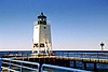
The first light in Charlevoix, built in 1884, was located on the north pier. This light was replaced in 1948 with the current steel structure, which was located on the south pier. The lens and lantern from the old structure were transferred to the new one.
This building, constructed in 1892, served rail passengers until 1962. It has been renovated, and is currently owned by the Charlevoix Historical Society.
Built in 1899, this building shares a wall with the adjoining Votruba Block. Both buildings have been rehabilitated to form the Main Street Center office complex.
This church was founded in 1844 by Peter Greensky (1807-1866) also known as Shagasokicki, a Chippewa chief who had been converted to Christianity and became a preacher. The first services were held in makeshift buildings of bark and boughs until the 1850s, when a church was constructed from lumber brought by canoe from Traverse City.
Dating from 1877/78, the Horton Bay General Store is mentioned in two of Ernest Hemingway's short stories, "Up in Michigan" and "The Last Good Country." The store has operated more or less continuously since its construction.
Dating from 1877/78, the Red Fox Inn is mentioned in Ernest Hemingway's short story, "Up in Michigan," and tradition has it that the inn's proprietor during the 1910s and 20s, Vollie Fox, taught Hemingway how to fish. It is now a memoriabili and book store.
The Mormon Print Shop was built in 1850 by the followers of James Strang, who founded a Mormon sect after the death of Joseph Smith. It is now used by the Beaver Island Historical Society as a historical museum, the Old Mormon Print Shop Museum
Also designated 20CX19, this is a multicomponent site, with evidence of occupation during the Archaic (c. 3000 BC), Middle Woodland (c. AD 100), and Late Woodland periods (c. AD 1400).
Also known as Elm Pointe, this estate was built for John J. Porter and his wife Eva in about 1925. John J. Porter and his father William P. Porter headed the East Jordan Lumber Company and later the East Jordan Canning Company. The estate is now a public park, and houses the East Jordan Portside Art and Historical Society Museum.
Constructed by an Irish settler in about 1860, this log cabin was the home of Feodar (or Feodor) Protar from 1893 to 1925. Protar, a somewhat eccentric Russian emigre, was a self-taught and unlicensed physician, and served as Beaver Island's only doctor for many years.
Built in 1899, this building shares a wall with the adjoining East Jordan Lumber Company Store Building. Both buildings have been rehabilitated to form the Main Street Center office complex.
The Wolverine Hotel, also known as the Dilworth Hotel or the Wolverine-Dilworth Inn, was built in 1911/12. It is the only remaining hotel in the Boyne area dating from the turn-of-the-century era when Boyne City was a booming lumber town.
This is a list of properties on the National Register of Historic Places in the U.S. state of Michigan. This National Park Service list is complete through NPS recent listings posted June 24, 2022.
The following is a list of Registered Historic Places in Allegan County, Michigan. This National Park Service list is complete through NPS recent listings posted June 24, 2022.
This is a list of the National Register of Historic Places listings in Berrien County, Michigan.
This is a list of the National Register of Historic Places listings in Cheboygan County, Michigan.
This is a list of the National Register of Historic Places listings in Emmet County, Michigan.
This is a list of the National Register of Historic Places listings in Delta County, Michigan.
This is a list of the National Register of Historic Places listings in Mackinac County, Michigan.
The following is a list of Registered Historic Places in Muskegon County, Michigan. This National Park Service list is complete through NPS recent listings posted June 24, 2022.
This is a list of the National Register of Historic Places listings in Saginaw County, Michigan.
This is a list of the National Register of Historic Places listings in Gratiot County, Michigan.
The Brown Site, designated 20GR21, is an archaeological site located along the Pine River near Tyler Road, south of Alma College. It is situated on a sandy point near a small creek. The site was discovered in 1976 as part of a survey of the Pine River watershed by researchers from Alma College, and excavations were conducted in 1977 and 1979. It is the site of a late Woodland period village dating to about AD 1000, covering 0.8 acres (0.32 ha).
The Charlevoix City Park Site is an archaeological site located between Bridge Street and Round Lake in Charlevoix, Michigan. It was listed on the National Register of Historic Places in 1972.
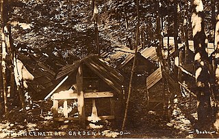
The Garden Island Indian Cemetery, also designated 20CX12, is an archaeological site and Ojibwe burial site. located on Garden Island in Charlevoix County, Michigan. It was listed on the National Register of Historic Places in 1978.
The Mt. McSauba Site, also designated 20CX23, is an archaeological site located near Charlevoix, Michigan. It was listed on the National Register of Historic Places in 1976. The site is an encampment on a dune.
The O'Neill Site, also designated 20CX18, is an archaeological site located about 5 km south Charlevoix, Michigan. It was listed on the National Register of Historic Places in 1971.
The Pewangoing Quarry, also designated 20CX20, is an archaeological site located along Lake Michigan just north of Norwood, Michigan. It was listed on the National Register of Historic Places in 1972, and is included in the Pi-wan-go-ning Prehistoric District.
The Pi-wan-go-ning Prehistoric District is a collection of three archaeological sites located along Lake Michigan just north of Norwood, Michigan. The three sites are the Pewangoing Quarry ; Whiskey Creek ; and Fritz Trail. The district was listed on the National Register of Historic Places in 1973.
The Pine River Site, also designated 20CX19, is an archaeological site located in Charlevoix, Michigan. It was listed on the National Register of Historic Places in 1972.
The Wood Site is an archaeological site located in Hayes Township in Charlevoix County, Michigan. It was listed on the National Register of Historic Places in 1976.
The Mahoney Site, designated 20SA193, is an archaeological site located near Bridgeport, Michigan. It was listed on the National Register of Historic Places in 1982.
References
↑ The latitude and longitude information provided in this table was derived originally from the National Register Information System, which has been found to be fairly accurate for about 99% of listings. Some locations in this table may have been corrected to current GPS standards.
↑ Numbers represent an alphabetical ordering by significant words. Various colorings, defined here, differentiate National Historic Landmarks and historic districts from other NRHP buildings, structures, sites or objects.
↑ The eight-digit number below each date is the number assigned to each location in the National Register Information System database, which can be viewed by clicking the number.
↑ The NRIS lists the Garden Island Indian Cemetery as "Address Restricted." However, references place it on Garden Island. Geo-coordinates are approximate.
↑ The NRIS lists the Mt. McSauba Site as "Address Restricted." However, references place it at Mt. McSauba. Geo-coordinates are approximate.
↑ The NRIS lists the O'Neill site as "Address Restricted." However, references place it at the mouth of Inwood Creek. Geo-coordinates are approximate.
↑ The NRIS lists the Pewangoing Quarry as "Address Restricted." However, references James Vol Hartwell (May 29, 2010), "Pi-wan-go-ning Arrowhead Quarry", Petosket News place it just North of Norwood, near Whiskey Creek. Geo-coordinates are approximate.
↑ The NRIS lists the Pewangoing Quarry as "Address Restricted." However, references James Vol Hartwell (May 29, 2010), "Pi-wan-go-ning Arrowhead Quarry", Petosket News place it just North of Norwood, near Whiskey Creek. Geo-coordinates are approximate.
↑ The NRIS lists the Pine River site as "Address Restricted." However, references (J. Alan Holman; Margaret B. Holman (2009), The Michigan Roadside Naturalist, University of Michigan Press, pp.158–159, ISBN9780472024599 ) place it at the north side of the Pine River channel. Geo-coordinates are approximate.
↑ The NRIS lists the Wood site as "Address Restricted." However, references (H. R. Crane; James B. Griffin (1972), "UNIVERSITY OF MICHIGAN RADIOCARBON DATES XIV", Radiocarbon, 14 (1): 155–194, doi:10.1017/S0033822200001077) place it north of Charlevoix. Geo-coordinates are approximate.
This page is based on this Wikipedia article Text is available under the CC BY-SA 4.0 license; additional terms may apply. Images, videos and audio are available under their respective licenses.