National Register of Historic Places listings in Deer Lodge County, Montana

Last updated

Location of Deer Lodge County in Montana Map of Montana highlighting Deer Lodge County.svg
Location of Deer Lodge County in Montana

This is a list of the National Register of Historic Places listings in Deer Lodge County, Montana. It is intended to be a complete list of the properties and districts on the National Register of Historic Places in Deer Lodge County, Montana, United States. All sites are located in the city of Anaconda, which is consolidated with Deer Lodge County. The locations of National Register properties and districts for which the latitude and longitude coordinates are included below, may be seen in a map. [1]

Contents

There are 35 properties and districts listed on the National Register in the county, including 1 National Historic Landmark.


    This National Park Service list is complete through NPS recent listings posted March 22, 2024. [2]

Listings county-wide

[3] Name on the Register [4] ImageDate listed [5] Location City or townDescription
1 Alpine Apartments
Alpine Apartments Alpine Apartments NRHP 98001299 Deer Lodge County, MT.jpg
Alpine Apartments
October 30, 1998
(#98001299)
200 Hickory
46°07′46″N112°57′13″W / 46.129444°N 112.953611°W / 46.129444; -112.953611 (Alpine Apartments)
Anaconda
2 Anaconda Commercial Historic District
Anaconda Commercial Historic District Main Street in Anaconda.jpg
Anaconda Commercial Historic District
February 25, 1998
(#98000155)
Roughly bounded by Commercial Ave., Main St., Chestnut St., and E. Park Ave.
46°07′46″N112°56′57″W / 46.129444°N 112.949167°W / 46.129444; -112.949167 (Anaconda Commercial Historic District)
Anaconda
3 Anaconda Copper Mining Company Smoke Stack
Anaconda Copper Mining Company Smoke Stack Anaconda Stack.jpg
Anaconda Copper Mining Company Smoke Stack
April 9, 1987
(#87000607)
Anaconda Copper Smelter
46°06′37″N112°54′47″W / 46.110278°N 112.913056°W / 46.110278; -112.913056 (Anaconda Copper Mining Company Smoke Stack)
Anaconda
4 Anaconda Saddle Club
Anaconda Saddle Club Anaconda Saddle Club NRHP 06001296 Deer Lodge County, MT.jpg
Anaconda Saddle Club
January 24, 2007
(#06001296)
2704 Montana Highway 1, W.
46°09′22″N113°02′07″W / 46.1562°N 113.0353°W / 46.1562; -113.0353 (Anaconda Saddle Club)
Anaconda
5 Ancient Order of Hibernians Hall
Ancient Order of Hibernians Hall Ancient Order of Hibernians Hall, Anaconda.jpg
Ancient Order of Hibernians Hall
August 10, 1979
(#79003721)
321-323 E. Commercial
46°07′46″N112°56′54″W / 46.129444°N 112.948333°W / 46.129444; -112.948333 (Ancient Order of Hibernians Hall)
Anaconda
6 Barich Block
Barich Block Barich Block.jpg
Barich Block
January 19, 1983
(#83001058)
416-420 E. Park Ave.
46°07′47″N112°57′05″W / 46.129722°N 112.951389°W / 46.129722; -112.951389 (Barich Block)
Anaconda
7 Branscombe Automobile Machine Shop
Branscombe Automobile Machine Shop Branscombe Automobile Machine Shop (site) NRHP 00001522 Deer Lodge County, MT.jpg
Branscombe Automobile Machine Shop
December 18, 2000
(#00001522)
125 W. Commercial
46°07′56″N112°57′14″W / 46.132222°N 112.953889°W / 46.132222; -112.953889 (Branscombe Automobile Machine Shop)
Anaconda
8 Butte, Anaconda and Pacific Railway Historic District
Butte, Anaconda and Pacific Railway Historic District Butte, Anaconda and Pacific Railway Headquarters.jpg
Butte, Anaconda and Pacific Railway Historic District
October 13, 1988
(#88001111)
Right-of-way begins in Butte and travels to Anaconda, generally along the course of Silver Bow Creek
46°02′37″N112°44′25″W / 46.043611°N 112.740278°W / 46.043611; -112.740278 (Butte, Anaconda and Pacific Railway Historic District)
Anaconda Extends into Silver Bow County
9 Butte-Anaconda Historic District
Butte-Anaconda Historic District Durston Building, Anaconda.jpg
Butte-Anaconda Historic District
October 15, 1966
(#66000438)
Most of the developed areas of Anaconda, Butte, and Walkerville
46°07′45″N112°57′10″W / 46.129167°N 112.952778°W / 46.129167; -112.952778 (Butte-Anaconda Historic District)
Anaconda Extends into Silver Bow County
10 California Creek Quarry January 20, 1989
(#88003140)
Address restricted [6]
Anaconda
11 City Hall
City Hall Anaconda City Hall NRHP 79003722 Deer Lodge County, MT.jpg
City Hall
August 10, 1979
(#79003722)
401 E. Commercial
46°07′46″N112°56′51″W / 46.129444°N 112.9475°W / 46.129444; -112.9475 (City Hall)
Anaconda
12 Club Moderne
Club Moderne Club Moderne, Anaconda, Montana.jpg
Club Moderne
August 14, 1986
(#86001498)
811 E. Park
46°07′40″N112°56′38″W / 46.127778°N 112.943889°W / 46.127778; -112.943889 (Club Moderne)
Anaconda Heavily damaged by fire October 3, 2016 [7]
13 James V. Collins House
James V. Collins House Collins House NRHP 00001521 Deer Lodge County, MT.jpg
James V. Collins House
December 18, 2000
(#00001521)
422 W. 3rd St.
46°07′52″N112°57′31″W / 46.131111°N 112.958611°W / 46.131111; -112.958611 (James V. Collins House)
Anaconda
14 Davidson Building
Davidson Building Davidson Building NRHP 83001059 Deer Lodge County, MT.jpg
Davidson Building
January 19, 1983
(#83001059)
301-303 E. Park St.
46°07′47″N112°57′14″W / 46.129722°N 112.953889°W / 46.129722; -112.953889 (Davidson Building)
Anaconda
15 Deer Lodge County Courthouse
Deer Lodge County Courthouse Anaconda-Courthouse.jpg
Deer Lodge County Courthouse
December 29, 1978
(#78001681)
U.S. Route 10
46°07′21″N112°57′18″W / 46.1225°N 112.955°W / 46.1225; -112.955 (Deer Lodge County Courthouse)
Anaconda
16 Driver's Saloon and Café February 7, 2023
(#100008428)
104-106 East Commercial Ave.
46°07′49″N112°57′09″W / 46.1303°N 112.9524°W / 46.1303; -112.9524 (Driver's Saloon and Café)
Anaconda
17 Theodore Eck House
Theodore Eck House Eck House NRHP 98001298 Deer Lodge County, MT.jpg
Theodore Eck House
October 30, 1998
(#98001298)
1217 W. 4th St.
46°07′48″N112°58′10″W / 46.13°N 112.969444°W / 46.13; -112.969444 (Theodore Eck House)
Anaconda
18 John Furst House
John Furst House Furst House NRHP 98001296 Deer Lodge, MT.jpg
John Furst House
October 30, 1998
(#98001296)
1403 W. 3rd St.
46°07′53″N112°58′16″W / 46.131389°N 112.971111°W / 46.131389; -112.971111 (John Furst House)
Anaconda
19 Glenn's Dam Historic District March 16, 2020
(#100005107)
North Cable Rd., less than 1/4 mi. north of northwest end of town
46°08′32″N112°58′59″W / 46.1421°N 112.9831°W / 46.1421; -112.9831 (Glenn's Dam Historic District)
Anaconda vicinity
20 Glover Cabin
Glover Cabin Glover Cabin NRHP 00001524 Deer Lodge County, MT.jpg
Glover Cabin
December 18, 2000
(#00001524)
Washoe Park
46°08′10″N112°57′56″W / 46.136111°N 112.965556°W / 46.136111; -112.965556 (Glover Cabin)
Anaconda
21 Goosetown Historic District
Goosetown Historic District Parrott Block, Anaconda, Montana.jpg
Goosetown Historic District
February 25, 1998
(#98000156)
Roughly bounded by Cedar St., Monroe St., the Birch Hill Allotment, and E. Commercial Ave.
46°07′28″N112°56′35″W / 46.124444°N 112.943056°W / 46.124444; -112.943056 (Goosetown Historic District)
Anaconda
22 Granite Apartments
Granite Apartments Granite Apartments NRHP 00001517 Deer Lodge County, MT.jpg
Granite Apartments
December 18, 2000
(#00001517)
214 E. 3rd St.
46°07′48″N112°57′04″W / 46.13°N 112.951111°W / 46.13; -112.951111 (Granite Apartments)
Anaconda
23 Hearst Free Library
Hearst Free Library Hearst Free Library, Anaconda.jpg
Hearst Free Library
June 4, 1973
(#73001051)
Main and 4th Sts.
46°07′37″N112°57′09″W / 46.126944°N 112.9525°W / 46.126944; -112.9525 (Hearst Free Library)
Anaconda
24 Lorraine Apartments
Lorraine Apartments Lorraine Apartments NRHP 00001520 Deer Lodge County, MT.jpg
Lorraine Apartments
December 18, 2000
(#00001520)
218 E. 3rd
46°07′47″N112°57′02″W / 46.129722°N 112.950556°W / 46.129722; -112.950556 (Lorraine Apartments)
Anaconda
25 Duncan Matheson House
Duncan Matheson House Matheson House NRHP 98001295 Deer Lodge County, MT.jpg
Duncan Matheson House
October 30, 1998
(#98001295)
1300 W. 3rd St.
46°07′53″N112°58′10″W / 46.131389°N 112.969444°W / 46.131389; -112.969444 (Duncan Matheson House)
Anaconda
26 Methodist Episcopal Church of Anaconda
Methodist Episcopal Church of Anaconda Methodist Episcopal Church of Anaconda2 NRHP 94000783 Deer Lodge County, MT (2).jpg
Methodist Episcopal Church of Anaconda
July 29, 1994
(#94000783)
Junction of Oak and E. 3rd Sts.
46°07′42″N112°57′02″W / 46.128333°N 112.950556°W / 46.128333; -112.950556 (Methodist Episcopal Church of Anaconda)
Anaconda
27 Morel Bridge December 12, 2000
(#00001491)
25200 East Side Rd.
46°09′28″N112°46′16″W / 46.157778°N 112.771111°W / 46.157778; -112.771111 (Morel Bridge)
Anaconda
28 The New Brunswick House
The New Brunswick House New Brunswick House NRHP 00001514 Deer Lodge County, MT.jpg
The New Brunswick House
December 18, 2000
(#00001514)
325 E. Front
46°07′56″N112°56′54″W / 46.132222°N 112.948333°W / 46.132222; -112.948333 (The New Brunswick House)
Anaconda
29 Sheehan Boardinghouse
Sheehan Boardinghouse Sheehan Boardinghouse NRHP 00001519 Deer Lodge County, MT.jpg
Sheehan Boardinghouse
December 18, 2000
(#00001519)
412 E. 3rd St.
46°07′42″N112°56′54″W / 46.128333°N 112.948333°W / 46.128333; -112.948333 (Sheehan Boardinghouse)
Anaconda
30 St. Mark's Episcopal Church
St. Mark's Episcopal Church Saint Mark's Episcopal Church NRHP 78001682 Deer Lodge County, MT.jpg
St. Mark's Episcopal Church
December 29, 1978
(#78001682)
601 Main St.
46°07′29″N112°57′14″W / 46.124722°N 112.953889°W / 46.124722; -112.953889 (St. Mark's Episcopal Church)
Anaconda
31 US Post Office-Anaconda Main
US Post Office-Anaconda Main US Post Office - Anaconda Main NRHP 86000677 Deer Lodge County, MT.jpg
US Post Office-Anaconda Main
March 14, 1986
(#86000677)
218 Main St.
46°07′44″N112°57′09″W / 46.128889°N 112.9525°W / 46.128889; -112.9525 (US Post Office-Anaconda Main)
Anaconda
32 George Waddell House
George Waddell House Waddell House NRHP 98001300 Deer Lodge County, MT.jpg
George Waddell House
October 30, 1998
(#98001300)
506 W. 3rd St.
46°07′46″N112°57′30″W / 46.129444°N 112.958333°W / 46.129444; -112.958333 (George Waddell House)
Anaconda
33 Washoe Theater
Washoe Theater Washoe Theater.jpg
Washoe Theater
April 30, 1982
(#82003162)
305 Main St.
46°07′39″N112°57′08″W / 46.1275°N 112.952222°W / 46.1275; -112.952222 (Washoe Theater)
Anaconda
34 West Side Historic District
West Side Historic District West Side HD2 98000396 Deer Lodge County, MT.jpg
West Side Historic District
April 28, 1998
(#98000396)
Roughly bounded by Main St., W. 8th St., W. Park Ave., and Maple St.
46°07′33″N112°57′17″W / 46.125833°N 112.954722°W / 46.125833; -112.954722 (West Side Historic District)
Anaconda
35 Zion Swedish Evangelical Lutheran Church
Zion Swedish Evangelical Lutheran Church Zion Swedish Evangelical Lutheran Church NRHP 98001297 Deer Lodge County, MT.jpg
Zion Swedish Evangelical Lutheran Church
October 30, 1998
(#98001297)
524 Cedar St.
46°07′29″N112°56′57″W / 46.124722°N 112.949167°W / 46.124722; -112.949167 (Zion Swedish Evangelical Lutheran Church)
Anaconda

Former listings

[3] Name on the RegisterImageDate listedDate removedLocationCity or townDescription
1 Montana Hotel, briefly Marcus Daly Hotel
Montana Hotel, briefly Marcus Daly Hotel Montana Hotel - Anaconda MT.jpg
Montana Hotel, briefly Marcus Daly Hotel
April 26, 1973
(#73001052)
June 18, 1979Park Ave. and S. Main St.
Anaconda Briefly known as the Marcus Daly Hotel in the 1970s, the structure lost a significant amount of its original character when the upper two floors were removed [8]
2 Durston Block and Annex
Durston Block and Annex Durston Building, Anaconda, Montana.jpg
Durston Block and Annex
January 18, 1984
(#84002461)
June 3, 1986201-205 1/2 Main St.
Anaconda Destroyed by fire on February 9, 1985. [9]

See also

Related Research Articles

<span class="mw-page-title-main">National Register of Historic Places listings in Montana</span>

This is a list of properties and historic districts in Montana that are listed on the National Register of Historic Places. The state's more than 1,100 listings are distributed across all of its 56 counties.

<span class="mw-page-title-main">National Register of Historic Places listings in Cascade County, Montana</span>

This is a list of the National Register of Historic Places listings in Cascade County, Montana. It is intended to be a complete list of the properties and districts on the National Register of Historic Places in Cascade County, Montana, United States. The locations of National Register properties and districts for which the latitude and longitude coordinates are included below, may be seen in a map.

<span class="mw-page-title-main">National Register of Historic Places listings in Carbon County, Montana</span>

This is a list of the National Register of Historic Places listings in Carbon County, Montana.

<span class="mw-page-title-main">National Register of Historic Places listings in Gallatin County, Montana</span>

This is a list of the National Register of Historic Places listings in Gallatin County, Montana.

<span class="mw-page-title-main">National Register of Historic Places listings in Lewis and Clark County, Montana</span>

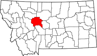
This is a list of the National Register of Historic Places listings in Lewis and Clark County, Montana.

<span class="mw-page-title-main">National Register of Historic Places listings in Missoula County, Montana</span>

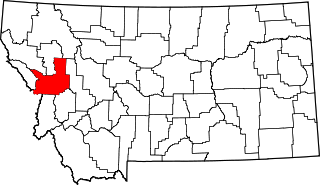
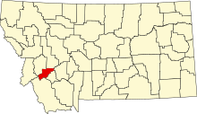
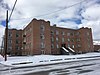
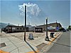
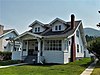
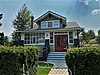
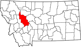
This is a list of the National Register of Historic Places listings in Missoula County, Montana. It is intended to be a complete list of the properties and districts on the National Register of Historic Places in Missoula County, Montana, United States. The locations of National Register properties and districts for which the latitude and longitude coordinates are included below, may be seen in a map.

<span class="mw-page-title-main">National Register of Historic Places listings in Yellowstone County, Montana</span>

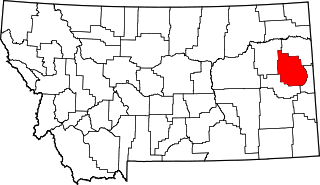
This is a list of the National Register of Historic Places listings in Yellowstone County, Montana. It is intended to be a complete list of the properties and districts on the National Register of Historic Places in Yellowstone County, Montana, United States. The locations of National Register properties and districts for which the latitude and longitude coordinates are included below, may be seen in a map.

<span class="mw-page-title-main">National Register of Historic Places listings in Park County, Montana</span>

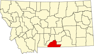
This is a list of the National Register of Historic Places listings in Park County, Montana.

<span class="mw-page-title-main">National Register of Historic Places listings in Glacier County, Montana</span>

This is a list of the National Register of Historic Places listings in Glacier County, Montana. It is intended to be a complete list of the properties and districts on the National Register of Historic Places in Glacier County, Montana, United States. The locations of National Register properties and districts for which the latitude and longitude coordinates are included below, may be seen in a map.

<span class="mw-page-title-main">National Register of Historic Places listings in Chouteau County, Montana</span>

This is a list of the National Register of Historic Places listings in Chouteau County, Montana. It is intended to be a complete list of the properties and districts on the National Register of Historic Places in Chouteau County, Montana, United States. The locations of National Register properties and districts for which the latitude and longitude coordinates are included below, may be seen in a map.

<span class="mw-page-title-main">National Register of Historic Places listings in Beaverhead County, Montana</span>

This is a list of the National Register of Historic Places listings in Beaverhead County, Montana. It is intended to be a complete list of the properties and districts on the National Register of Historic Places in Beaverhead County, Montana, United States. The locations of National Register properties and districts for which the latitude and longitude coordinates are included below, may be seen in a map.

<span class="mw-page-title-main">National Register of Historic Places listings in Dawson County, Montana</span>

This is a list of the National Register of Historic Places listings in Dawson County, Montana. It is intended to be a complete list of the properties and districts on the National Register of Historic Places in Dawson County, Montana, United States. The locations of National Register properties and districts for which the latitude and longitude coordinates are included below, may be seen in a map.

<span class="mw-page-title-main">National Register of Historic Places listings in Edgecombe County, North Carolina</span>

This list includes properties and districts listed on the National Register of Historic Places in Edgecombe County, North Carolina, United States. Click the "Map of all coordinates" link to the right to view a Google map of all properties and districts with latitude and longitude coordinates in the table below.

<span class="mw-page-title-main">National Register of Historic Places listings in Pitt County, North Carolina</span>

This list includes properties and districts listed on the National Register of Historic Places in Pitt County, North Carolina. Click the "Map of all coordinates" link to the right to view an online map of all properties and districts with latitude and longitude coordinates in the table below.

<span class="mw-page-title-main">National Register of Historic Places listings in Jefferson County, Missouri</span>

This is a list of the National Register of Historic Places listings in Jefferson County, Missouri.

<span class="mw-page-title-main">National Register of Historic Places listings in Concordia Parish, Louisiana</span>

This is a list of the National Register of Historic Places listings in Concordia Parish, Louisiana.

<span class="mw-page-title-main">National Register of Historic Places listings in Lake County, Montana</span>

This is a list of the National Register of Historic Places listings in Lake County, Montana. It is intended to be a complete list of the properties and districts on the National Register of Historic Places in Lake County, Montana, United States. The locations of National Register properties and districts for which the latitude and longitude coordinates are included below, may be seen in a map.

<span class="mw-page-title-main">National Register of Historic Places listings in Blaine County, Montana</span>

This is a list of the National Register of Historic Places listings in Blaine County, Montana. It is intended to be a complete list of the properties and districts on the National Register of Historic Places in Blaine County, Montana, United States. The locations of National Register properties and districts for which the latitude and longitude coordinates are included below, may be seen in a map.

<span class="mw-page-title-main">National Register of Historic Places listings in Jefferson County, Montana</span>

This is a list of the National Register of Historic Places listings in Jefferson County, Montana. It is intended to be a complete list of the properties and districts on the National Register of Historic Places in Jefferson County, Montana, United States. The locations of National Register properties and districts for which the latitude and longitude coordinates are included below, may be seen in a map.

<span class="mw-page-title-main">National Register of Historic Places listings in Armstrong County, Texas</span>

This is a list of the National Register of Historic Places listings in Armstrong County, Texas.

References

  1. The latitude and longitude information provided in this table was derived originally from the National Register Information System, which has been found to be fairly accurate for about 99% of listings. Some locations in this table may have been corrected to current GPS standards.
  2. National Park Service, United States Department of the Interior, "National Register of Historic Places: Weekly List Actions", retrieved March 22, 2024.
  3. 1 2 Numbers represent an alphabetical ordering by significant words. Various colorings, defined here, differentiate National Historic Landmarks and historic districts from other NRHP buildings, structures, sites or objects.
  4. "National Register Information System". National Register of Historic Places . National Park Service. April 24, 2008.
  5. The eight-digit number below each date is the number assigned to each location in the National Register Information System database, which can be viewed by clicking the number.
  6. Federal and state laws and practices restrict general public access to information regarding the specific location of this resource. In some cases, this is to protect archeological sites from vandalism, while in other cases it is restricted at the request of the owner. See: Knoerl, John; Miller, Diane; Shrimpton, Rebecca H. (1990), Guidelines for Restricting Information about Historic and Prehistoric Resources, National Register Bulletin, National Park Service, U.S. Department of the Interior, OCLC   20706997 .
  7. "Life after death: Historic Anaconda bar reborn after devastation by fire".
  8. Hawley, Monica (1984). "Anaconda Historic District - Marcus Daly Hotel" (PDF). Historic American Buildings Survey . Retrieved January 26, 2016.
  9. "Fire claims historic building in Anaconda". The Montana Standard . February 10, 1985. p. 1. Retrieved August 4, 2022 via Newspapers.com.