National Register of Historic Places listings in Iron County, Wisconsin

Last updated
Location of Iron County in Wisconsin Map of Wisconsin highlighting Iron County.svg
Location of Iron County in Wisconsin

This is a list of the National Register of Historic Places listings in Iron County, Wisconsin. It is intended to provide a comprehensive listing of entries in the National Register of Historic Places that are located in Iron County, Wisconsin. The locations of National Register properties for which the latitude and longitude coordinates are included below may be seen in a map. [1]

National Register of Historic Places Federal list of historic sites in the United States

The National Register of Historic Places (NRHP) is the United States federal government's official list of districts, sites, buildings, structures and objects deemed worthy of preservation for their historical significance. A property listed in the National Register, or located within a National Register Historic District, may qualify for tax incentives derived from the total value of expenses incurred in preserving the property.

Iron County, Wisconsin U.S. county in Wisconsin

Iron County is a county located in the U.S. state of Wisconsin. As of the 2010 census, the population was 5,916, making it the third-least populous county in Wisconsin. Its county seat is Hurley. It was named for the valuable iron ore found within its borders.

Contents

There are 5 properties and districts listed on the National Register in the county.

This National Park Service list is complete through NPS recent listings posted September 19, 2019. [2]
Map all coordinates using: OpenStreetMap  
Download coordinates as: KML  ·  GPX

Current listings

[3] Name on the RegisterImageDate listed [4] Location City or townDescription
1 Annala Round Barn
Annala Round Barn Annala Round Barn Buildings Hurley Iron County Wisconsin.jpg
Annala Round Barn
August 27, 1979
(#79000085)
S of Hurley
46°25′05″N90°09′41″W / 46.418056°N 90.161389°W / 46.418056; -90.161389 (Annala Round Barn)
Hurley Round barn and round milkhouse built of fieldstones in 1917 by Finnish stonemason Matt Annala. [5] [6]
2 Montreal Company Location Historic District
Montreal Company Location Historic District Montreal Company Historic District Larger House Style August 2012.jpg
Montreal Company Location Historic District
May 23, 1980
(#80000141)
WI 77
46°25′35″N90°13′50″W / 46.426389°N 90.230556°W / 46.426389; -90.230556 (Montreal Company Location Historic District)
Montreal The Montreal Mining Company built a planned community for employees in the first few decades of the 20th century, [7] [8] including arrays of homes for workers, the mine's machine shop, the Hamilton Club, the Roosevelt school, community gardens, and Sacred Heart of Jesus Catholic Church. [9]
3 Old Iron County Courthouse
Old Iron County Courthouse 2009-0617-OldIronCtyCourthouse-Hurley.jpg
Old Iron County Courthouse
July 26, 1977
(#77000031)
303 Iron St.
46°26′52″N90°10′59″W / 46.447778°N 90.183056°W / 46.447778; -90.183056 (Old Iron County Courthouse)
Hurley 1893 courthouse with a 1922 Seth Thomas clockworks. [10]
4 Plummer Mine Headframe
Plummer Mine Headframe Plummer Mine Headframe Iron County Wisconsin.jpg
Plummer Mine Headframe
September 24, 1997
(#97001141)
0.25 mi (0.40 km). W of jct. of Plummer Mine Rd. and WI 77
46°24′25″N90°17′31″W / 46.406944°N 90.291944°W / 46.406944; -90.291944 (Plummer Mine Headframe)
Pence Headframe from which miners were lowered into a 2367 foot iron mine that operated from 1904 to 1924. Now the last headframe standing in Wisconsin. [11]
5 Springstead
Springstead Springstead - end of Stone Lk. Rd. 9.4 mi. W of Jct WI 47 and C.R.182.JPG
Springstead
April 17, 1997
(#97000326)
Jct. of Old Springfield Tote Rd. and WI 182
46°01′17″N90°07′26″W / 46.021389°N 90.123889°W / 46.021389; -90.123889 (Springstead)
Sherman Habitation on Stone Lake, where Chippewas once made maple sugar and where French Canadians settled around 1868. Later used as a northwoods resort. [12] [13]

See also

National Register of Historic Places listings in Wisconsin Wikimedia list article

This is a list of properties and districts listed on the National Register of Historic Places in Wisconsin. There are over 2,400 listed sites in Wisconsin. Each of the state's 72 counties has at least one listing on the National Register.

Related Research Articles

National Register of Historic Places listings in Rock County, Wisconsin Wikimedia list article

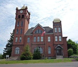
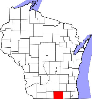
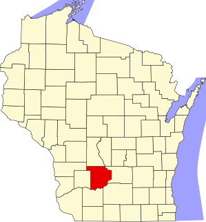
This is a list of the National Register of Historic Places listings in Rock County, Wisconsin. It is intended to provide a comprehensive listing of entries in the National Register of Historic Places that are located in Rock County, Wisconsin. The locations of National Register properties for which the latitude and longitude coordinates are included below may be seen in a map.

National Register of Historic Places listings in Sauk County, Wisconsin Wikimedia list article

This is a list of the National Register of Historic Places listings in Sauk County, Wisconsin. It is intended to provide a comprehensive listing of entries in the National Register of Historic Places that are located in Sauk County, Wisconsin. The locations of National Register properties for which the latitude and longitude coordinates are included below may be seen in a map.

National Register of Historic Places listings in Brown County, Wisconsin Wikimedia list article

This is a list of the National Register of Historic Places listings in Brown County, Wisconsin. It is intended to provide a comprehensive listing of entries in the National Register of Historic Places that are located in Brown County, Wisconsin. The locations of National Register properties for which the latitude and longitude coordinates are included below may be seen in a map.

National Register of Historic Places listings in Marinette County, Wisconsin Wikimedia list article

This is a list of the National Register of Historic Places listings in Marinette County, Wisconsin. It is intended to provide a comprehensive listing of entries in the National Register of Historic Places that are located in Marinette County, Wisconsin. The locations of National Register properties for which the latitude and longitude coordinates are included below may be seen in a map.

National Register of Historic Places listings in Bayfield County, Wisconsin Wikimedia list article

This is a list of the National Register of Historic Places listings in Bayfield County, Wisconsin. It is intended to provide a comprehensive listing of entries in the National Register of Historic Places that are located in Bayfield County, Wisconsin. The locations of National Register properties for which the latitude and longitude coordinates are included below may be seen in a map.

National Register of Historic Places listings in Trempealeau County, Wisconsin Wikimedia list article

This is a list of the National Register of Historic Places listings in Trempealeau County, Wisconsin. It is intended to provide a comprehensive listing of entries in the National Register of Historic Places that are located in Trempealeau County, Wisconsin. The locations of National Register properties for which the latitude and longitude coordinates are included below may be seen in a map.

National Register of Historic Places listings in Douglas County, Wisconsin Wikimedia list article

This is a list of the National Register of Historic Places listings in Douglas County, Wisconsin. It is intended to provide a comprehensive listing of entries in the National Register of Historic Places that are located in Douglas County, Wisconsin. The locations of National Register properties for which the latitude and longitude coordinates are included below may be seen in a map.

National Register of Historic Places listings in Kewaunee County, Wisconsin Wikimedia list article

This is a list of the National Register of Historic Places listings in Kewaunee County, Wisconsin. It is intended to provide a comprehensive listing of entries in the National Register of Historic Places that are located in Kewaunee County, Wisconsin. The locations of National Register properties for which the latitude and longitude coordinates are included below may be seen in a map.

National Register of Historic Places listings in Portage County, Wisconsin Wikimedia list article

This is a list of the National Register of Historic Places listings in Portage County, Wisconsin. It is intended to provide a comprehensive listing of entries in the National Register of Historic Places that are located in Portage County, Wisconsin. The locations of National Register properties for which the latitude and longitude coordinates are included below may be seen in a map.

National Register of Historic Places listings in Lincoln County, Wisconsin Wikimedia list article

This is a list of the National Register of Historic Places listings in Lincoln County, Wisconsin. It is intended to provide a comprehensive listing of entries in the National Register of Historic Places that are located in Lincoln County, Wisconsin. The locations of National Register properties for which the latitude and longitude coordinates are included below may be seen in a map.

National Register of Historic Places listings in Pierce County, Wisconsin Wikimedia list article

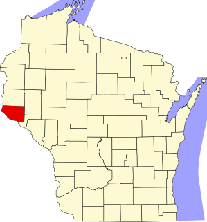
This is a list of the National Register of Historic Places listings in Pierce County, Wisconsin. It is intended to provide a comprehensive listing of entries in the National Register of Historic Places that are located in Pierce County, Wisconsin. The locations of National Register properties for which the latitude and longitude coordinates are included below may be seen in a map.

National Register of Historic Places listings in Chippewa County, Wisconsin Wikimedia list article

This is a list of the National Register of Historic Places listings in Chippewa County, Wisconsin. It is intended to provide a comprehensive listing of entries in the National Register of Historic Places that are located in Chippewa County, Wisconsin. The locations of National Register properties for which the latitude and longitude coordinates are included below may be seen in a map.

National Register of Historic Places listings in Waushara County, Wisconsin Wikimedia list article

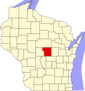
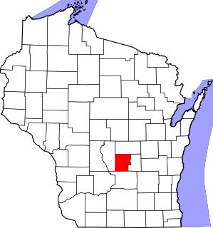
This is a list of the National Register of Historic Places listings in Waushara County, Wisconsin. It is intended to provide a comprehensive listing of entries in the National Register of Historic Places that are located in Waushara County, Wisconsin. The locations of National Register properties for which the latitude and longitude coordinates are included below may be seen in a map.

National Register of Historic Places listings in Buffalo County, Wisconsin Wikimedia list article

This is a list of the National Register of Historic Places listings in Buffalo County, Wisconsin. It is intended to provide a comprehensive listing of entries in the National Register of Historic Places that are located in Buffalo County, Wisconsin. The locations of National Register properties for which the latitude and longitude coordinates are included below may be seen in a map.

National Register of Historic Places listings in Calumet County, Wisconsin Wikimedia list article

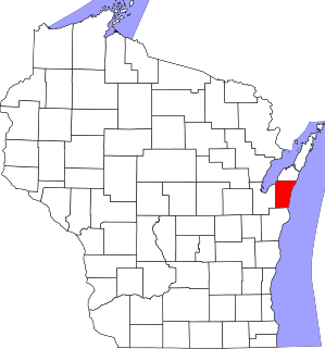
This is a list of the National Register of Historic Places listings in Calumet County, Wisconsin. It is intended to provide a comprehensive listing of entries in the National Register of Historic Places that are located in Calumet County, Wisconsin. The locations of National Register properties for which the latitude and longitude coordinates are included below may be seen in a map.

National Register of Historic Places listings in Taylor County, Wisconsin Wikimedia list article

This is a list of the National Register of Historic Places listings in Taylor County, Wisconsin. It is intended to provide a comprehensive listing of entries in the National Register of Historic Places that are located in Taylor County, Wisconsin. The locations of National Register properties for which the latitude and longitude coordinates are included below may be seen in a map.

National Register of Historic Places listings in Marquette County, Wisconsin Wikimedia list article

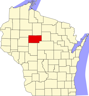
This is a list of the National Register of Historic Places listings in Marquette County, Wisconsin. It is intended to provide a comprehensive listing of entries in the National Register of Historic Places that are located in Marquette County, Wisconsin. The locations of National Register properties for which the latitude and longitude coordinates are included below may be seen in a map.

National Register of Historic Places listings in Florence County, Wisconsin Wikimedia list article

This is a list of the National Register of Historic Places listings in Florence County, Wisconsin. It is intended to provide a comprehensive listing of entries in the National Register of Historic Places that are located in Florence County, Wisconsin. The locations of National Register properties for which the latitude and longitude coordinates are included below may be seen in a map.

National Register of Historic Places listings in Jackson County, Wisconsin Wikimedia list article

This is a list of the National Register of Historic Places listings in Jackson County, Wisconsin. It is intended to provide a comprehensive listing of entries in the National Register of Historic Places that are located in Jackson County, Wisconsin. The locations of National Register properties for which the latitude and longitude coordinates are included below may be seen in a map.

National Register of Historic Places listings in Sawyer County, Wisconsin Wikimedia list article

This is a list of the National Register of Historic Places listings in Sawyer County, Wisconsin. It is intended to provide a comprehensive listing of entries in the National Register of Historic Places that are located in Sawyer County, Wisconsin. The locations of National Register properties for which the latitude and longitude coordinates are included below may be seen in a map.

References

  1. The latitude and longitude information provided is primarily from the National Register Information System, and has been found to be fairly accurate for about 99% of listings. For 1%, the location info may be way off. We seek to correct the coordinate information wherever it is found to be erroneous. Please leave a note in the Discussion page for this article if you believe any specific location is incorrect.
  2. "National Register of Historic Places: Weekly List Actions". National Park Service, United States Department of the Interior. Retrieved on September 19, 2019.
  3. Numbers represent an ordering by significant words. Various colorings, defined here, differentiate National Historic Landmarks and historic districts from other NRHP buildings, structures, sites or objects.
  4. The eight-digit number below each date is the number assigned to each location in the National Register Information System database, which can be viewed by clicking the number.
  5. "Matt Annala Round Barn". Architecture and History Inventory. Wisconsin Historical Society. Retrieved 2014-06-08.
  6. "Matt Annala Milkhouse". Architecture and History Inventory. Wisconsin Historical Society. Retrieved 2014-06-08.
  7. "Montreal Company Location Historic District". Wisconsin Historical Society. Retrieved 2011-11-13.
  8. "Penokee Iron Range Trail - a Company Town". The Historical Marker Database. Retrieved 2011-11-13.
  9. "List of properties in Montreal Company Location Historic District". Architecture and History Inventory. Wisconsin Historical Society. Retrieved 2014-06-08.
  10. "Iron County Courthouse". Wisconsin Historical Society. Retrieved 2014-06-08.
  11. "Penokee Iron Range Trail - Plummer Location". The Historical Marker Database. Retrieved 2011-11-13.
  12. "Iron County Development". Iron County Development Zone. Archived from the original on 2014-07-14. Retrieved 2014-06-08.
  13. "Springstead Post Office". Architecture and History Inventory. Wisconsin Historical Society. Retrieved 2014-06-08.