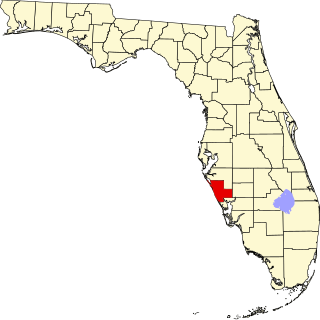
[3] Name on the Register [4] Image Date listed [5] Location City or town Description 1 Alderman House Alderman House December 1, 1988 (# 88002690 2572 First Street 26°38′52″N 81°51′44″W / 26.647778°N 81.862222°W / 26.647778; -81.862222 (Alderman House ) Fort Myers 2 Alva Consolidated Schools Alva Consolidated Schools June 10, 1999 (# 99000695 21291 North River Road 26°42′58″N 81°36′36″W / 26.716111°N 81.61°W / 26.716111; -81.61 (Alva Consolidated Schools ) Alva Part of the Lee County MPS 3 Boca Grande Community Center Boca Grande Community Center March 30, 1995 (# 95000306 East of Park Avenue, between First and Second Streets 26°44′48″N 82°15′42″W / 26.746667°N 82.261667°W / 26.746667; -82.261667 (Boca Grande Community Center ) Boca Grande Part of the Lee County MPS 4 Boca Grande Lighthouse Boca Grande Lighthouse February 28, 1980 (# 80000953 South of Boca Grande on Gasparilla Island 26°44′29″N 82°15′49″W / 26.741389°N 82.263611°W / 26.741389; -82.263611 (Boca Grande Lighthouse ) Boca Grande 5 Boca Grande Quarantine Station Boca Grande Quarantine Station March 22, 1996 (# 96000447 833 Belcher Road 26°43′10″N 82°15′42″W / 26.719444°N 82.261667°W / 26.719444; -82.261667 (Boca Grande Quarantine Station ) Boca Grande Part of the Lee County MPS 6 Bonita Springs School Bonita Springs School July 8, 1999 (# 99000800 10701 Dean Street 26°20′05″N 81°46′31″W / 26.334722°N 81.775278°W / 26.334722; -81.775278 (Bonita Springs School ) Bonita Springs Part of the Lee County MPS 7 Buckingham School Buckingham School February 17, 1989 (# 89000011 Buckingham and Cemetery Roads 26°40′18″N 81°43′57″W / 26.671667°N 81.7325°W / 26.671667; -81.7325 (Buckingham School ) Buckingham 8 Cabbage Key Historic District Upload image November 12, 2015 (# 15000784 Intracoastal Waterway Marker 60 in Pine Island Sound 26°39′22″N 82°13′25″W / 26.6560°N 82.2236°W / 26.6560; -82.2236 (Cabbage Key Historic District ) Pineland 9 Casa Rio Casa Rio October 24, 1996 (# 96001186 2424 McGregor Boulevard 26°38′00″N 81°52′53″W / 26.633333°N 81.881389°W / 26.633333; -81.881389 (Casa Rio ) Fort Myers Part of the Lee County MPS 10 Captiva School and Chapel-by-the-Sea Historic District Captiva School and Chapel-by-the-Sea Historic District October 23, 2013 (# 13000853 11580 Chapin Ln. 26°31′14″N 82°11′34″W / 26.520687°N 82.192672°W / 26.520687; -82.192672 (Captiva School and Chapel-by-the-Sea Historic District ) Captiva 11 Charlotte Harbor and Northern Railway Depot Charlotte Harbor and Northern Railway Depot December 13, 1979 (# 79000676 Park and 4th Streets 26°44′27″N 82°15′43″W / 26.740833°N 82.261944°W / 26.740833; -82.261944 (Charlotte Harbor and Northern Railway Depot ) Boca Grande 12 Dean Park Historic Residential District Dean Park Historic Residential District May 28, 2013 (# 13000319 Bounded by 1st St., Palm, Michigan & Evans Aves. 26°38′57″N 81°51′30″W / 26.649146°N 81.858444°W / 26.649146; -81.858444 (Dean Park Historic Residential District ) Fort Myers 13 Demere Key Upload image June 13, 1972 (# 72000332 Off Pine Island [6] 26°35′35″N 82°08′01″W / 26.5931°N 82.1336°W / 26.5931; -82.1336 (Demere Key ) Pine Island 14 Downtown Boca Grande Historic District Downtown Boca Grande Historic District August 24, 2011 (# 11000577 Bounded by Gilchrist Avenue W., 5th Street N., Palm Avenue E., & 3rd Street S., 26°45′01″N 82°15′39″W / 26.750278°N 82.260833°W / 26.750278; -82.260833 (Downtown Boca Grande Historic District ) Boca Grande 15 Paul Lawrence Dunbar School Paul Lawrence Dunbar School February 24, 1992 (# 92000025 1857 High Street 26°38′34″N 81°51′08″W / 26.642778°N 81.852222°W / 26.642778; -81.852222 (Paul Lawrence Dunbar School ) Fort Myers 16 Edison Park Elementary School Edison Park Elementary School May 5, 1999 (# 99000524 2401 Euclid Avenue 26°37′57″N 81°52′30″W / 26.6325°N 81.875°W / 26.6325; -81.875 (Edison Park Elementary School ) Fort Myers Part of the Lee County MPS 17 Thomas Edison Winter Estate Thomas Edison Winter Estate August 12, 1991 (# 91001044 2350 McGregor Boulevard 26°38′03″N 81°52′51″W / 26.634199°N 81.880776°W / 26.634199; -81.880776 (Thomas Edison Winter Estate ) Fort Myers 18 J. Colin English School J. Colin English School July 8, 1999 (# 99000798 120 Pine Island Road 26°40′56″N 81°53′17″W / 26.682222°N 81.888056°W / 26.682222; -81.888056 (J. Colin English School ) North Fort Myers Part of the Lee County MPS 19 First Baptist Church of Boca Grande First Baptist Church of Boca Grande December 2, 2009 (# 09000962 421 4th Street West 26°45′03″N 82°15′46″W / 26.750758°N 82.26275°W / 26.750758; -82.26275 (First Baptist Church of Boca Grande ) Boca Grande 20 Fish Cabin at White Rock Shoals Fish Cabin at White Rock Shoals April 11, 1991 (# 91000398 West of Pine Island in Pine Island Sound 26°32′41″N 82°07′19″W / 26.544722°N 82.121944°W / 26.544722; -82.121944 (Fish Cabin at White Rock Shoals ) St. James City Part of the Fish Cabins of Charlotte Harbor MPS 21 Henry Ford Estate Henry Ford Estate September 8, 1988 (# 88001822 2400 McGregor Boulevard 26°38′01″N 81°52′52″W / 26.633625°N 81.881221°W / 26.633625; -81.881221 (Henry Ford Estate ) Fort Myers 22 Fort Myers Beach School Fort Myers Beach School July 8, 1999 (# 99000796 2751 Oak Street 26°26′54″N 81°56′20″W / 26.448333°N 81.938889°W / 26.448333; -81.938889 (Fort Myers Beach School ) Fort Myers Beach Part of the Lee County MPS 23 Fort Myers Downtown Commercial District Fort Myers Downtown Commercial District January 26, 1990 (# 89002325 Roughly bounded by Bay and Lee Streets, Anderson Avenue, and Monroe Street 26°38′38″N 81°52′06″W / 26.643889°N 81.868333°W / 26.643889; -81.868333 (Fort Myers Downtown Commercial District ) Fort Myers 24 Galt Island Archeological District Upload image May 21, 1996 (# 96000531 Address Restricted 26°30′58″N 82°06′23″W / 26.516111°N 82.106389°W / 26.516111; -82.106389 (Galt Island Archeological District ) St. James City Part of the Archeological Resources of the Caloosahatchee Region MPS 25 Gasparilla Inn Historic District Gasparilla Inn Historic District March 18, 2008 (# 08000205 500 Palm Avenue 26°45′08″N 82°15′39″W / 26.752222°N 82.260833°W / 26.752222; -82.260833 (Gasparilla Inn Historic District ) Boca Grande 26 Gilmer Heitman House Gilmer Heitman House September 27, 1996 (# 96001033 2581 1st Street 26°38′55″N 81°51′46″W / 26.648611°N 81.862778°W / 26.648611; -81.862778 (Gilmer Heitman House ) Fort Myers Part of the Lee County MPS 27 Hendrickson Fish Cabin at Captiva Rocks Hendrickson Fish Cabin at Captiva Rocks April 11, 1991 (# 91000402 West of Little Wood Key in Pine Island Sound 26°37′42″N 82°11′29″W / 26.628333°N 82.191389°W / 26.628333; -82.191389 (Hendrickson Fish Cabin at Captiva Rocks ) Bokeelia Part of the Fish Cabins of Charlotte Harbor MPS 28 Ice House at Captiva Rocks Ice House at Captiva Rocks April 11, 1991 (# 91000407 Southwest of Little Wood Key in Pine Island Sound 26°37′35″N 82°11′07″W / 26.626389°N 82.185278°W / 26.626389; -82.185278 (Ice House at Captiva Rocks ) Bokeelia Part of the Fish Cabins of Charlotte Harbor MPS 29 Ice House at Point Blanco Ice House at Point Blanco April 11, 1991 (# 91000408 Southeast of Point Blanco Island in Pine Island Sound 26°40′30″N 82°13′31″W / 26.675°N 82.225278°W / 26.675; -82.225278 (Ice House at Point Blanco ) Bokeelia Part of the Fish Cabins of Charlotte Harbor MPS 30 Jewett-Thompson House Jewett-Thompson House September 29, 1988 (# 88001708 1141 Wales Drive 26°36′33″N 81°53′28″W / 26.609167°N 81.891111°W / 26.609167; -81.891111 (Jewett-Thompson House ) Fort Myers 31 Josslyn Island Site Upload image December 14, 1978 (# 78000948 Address Restricted 26°37′31″N 82°09′09″W / 26.625278°N 82.1525°W / 26.625278; -82.1525 (Josslyn Island Site ) Pineland Part of the Archeological Resources of the Caloosahatchee Region MPS 32 Journey's End Journey's End March 14, 1985 (# 85000554 Beachfront at 18th Street 26°45′44″N 82°15′57″W / 26.762222°N 82.265833°W / 26.762222; -82.265833 (Journey's End ) Boca Grande 33 Koreshan Unity Settlement Historic District Koreshan Unity Settlement Historic District May 4, 1976 (# 76000599 U.S. Route 41 at the Estero River 26°26′02″N 81°48′43″W / 26.433889°N 81.811944°W / 26.433889; -81.811944 (Koreshan Unity Settlement Historic District ) Estero 34 Larsen Fish Cabin at Captiva Rocks Larsen Fish Cabin at Captiva Rocks April 11, 1991 (# 91000404 West of Little Wood Key in Pine Island Sound 26°37′46″N 82°11′29″W / 26.629444°N 82.191389°W / 26.629444; -82.191389 (Larsen Fish Cabin at Captiva Rocks ) Bokeelia Part of the Fish Cabins of Charlotte Harbor MPS 35 Lee County Courthouse Lee County Courthouse March 16, 1989 (# 89000196 2120 Main Street 26°38′31″N 81°52′14″W / 26.641944°N 81.870556°W / 26.641944; -81.870556 (Lee County Courthouse ) Fort Myers 36 Leneer Fish Cabin at Captiva Rocks Leneer Fish Cabin at Captiva Rocks April 11, 1991 (# 91000403 West of Little Wood Key in Pine Island Sound 26°37′38″N 82°11′25″W / 26.627222°N 82.190278°W / 26.627222; -82.190278 (Leneer Fish Cabin at Captiva Rocks ) Bokeelia Part of the Fish Cabins of Charlotte Harbor MPS 37 Halstead and Emily Lindsley House Halstead and Emily Lindsley House August 4, 2011 (# 11000502 1300 West 13th Street 26°45′31″N 82°15′53″W / 26.758611°N 82.264722°W / 26.758611; -82.264722 (Halstead and Emily Lindsley House ) Boca Grande 38 Menge-Hansen Marine Ways Menge-Hansen Marine Ways September 2, 2009 (# 09000670 5605 Palm Beach Boulevard 26°41′16″N 81°47′35″W / 26.687778°N 81.793056°W / 26.687778; -81.793056 (Menge-Hansen Marine Ways ) Fort Myers 39 McCollum Hall McCollum Hall April 18, 2022 (# 100007618 2701 Dr. Martin Luther King, Jr. Blvd 26°38′28″N 81°51′28″W / 26.641048°N 81.857818°W / 26.641048; -81.857818 (McCollum Hall ) Fort Myers 40 Mound House Mound House March 22, 2019 (# 100002723 451 Connecticut St. 26°26′46″N 81°55′40″W / 26.4461°N 81.9279°W / 26.4461; -81.9279 (Mound House ) Fort Myers Beach 41 Mound Key Site Upload image August 12, 1970 (# 70000187 Address Restricted 26°25′20″N 81°51′55″W / 26.422222°N 81.865278°W / 26.422222; -81.865278 (Mound Key Site ) Fort Myers Beach Part of the Archeological Resources of the Caloosahatchee Region MPS 42 Murphy-Burroughs House Murphy-Burroughs House August 1, 1984 (# 84000898 2505 1st Street 26°38′49″N 81°51′57″W / 26.646944°N 81.865833°W / 26.646944; -81.865833 (Murphy-Burroughs House ) Fort Myers 43 Norton Fish Cabin at Captiva Rocks Norton Fish Cabin at Captiva Rocks April 11, 1991 (# 91000405 West of Little Wood Key in Pine Island Sound 26°37′47″N 82°11′32″W / 26.629722°N 82.192222°W / 26.629722; -82.192222 (Norton Fish Cabin at Captiva Rocks ) Bokeelia Part of the Fish Cabins of Charlotte Harbor MPS 44 Olga School Olga School April 27, 1995 (# 95000509 South Olga Road 26°43′03″N 81°42′47″W / 26.7175°N 81.713056°W / 26.7175; -81.713056 (Olga School ) Olga Part of the Lee County MPS 45 Mark Pardo Shellworks Site Upload image May 21, 1996 (# 96000533 Address Restricted Bokeelia Part of the Archeological Resources of the Caloosahatchee Region MPS 46 Pine--Aire Lodge Upload image October 8, 2014 (# 14000826 13771 Waterfront Dr. 26°39′41″N 82°09′16″W / 26.661342°N 82.154357°W / 26.661342; -82.154357 (Pine--Aire Lodge ) Bokeelia 47 Pineland Archeological District Upload image November 27, 1973 (# 73000583 Address Restricted Pineland Part of the Archeological Resources of the Caloosahatchee Region MPS 48 Punta Gorda Fish Company Cabin Punta Gorda Fish Company Cabin December 18, 2003 (# 03001289 Pine Island Sound 26°37′41″N 82°11′26″W / 26.628056°N 82.190556°W / 26.628056; -82.190556 (Punta Gorda Fish Company Cabin ) Bokeelia Part of the Fish Cabins of Charlotte Harbor MPS 49 Punta Gorda Fish Company Ice House Punta Gorda Fish Company Ice House April 20, 1989 (# 89000320 Northern shore of the entrance to Safety Harbor 26°35′56″N 82°12′49″W / 26.598889°N 82.213611°W / 26.598889; -82.213611 (Punta Gorda Fish Company Ice House ) North Captiva Island 50 Sanibel Colored School Sanibel Colored School July 8, 1999 (# 99000797 520 Tarpon Bay Road 26°26′21″N 82°03′53″W / 26.439167°N 82.064722°W / 26.439167; -82.064722 (Sanibel Colored School ) Sanibel Part of the Lee County MPS 51 Sanibel Lighthouse and Keeper's Quarters Sanibel Lighthouse and Keeper's Quarters October 1, 1974 (# 74000648 Point Ybel on Sanibel Island 26°27′10″N 82°00′51″W / 26.452778°N 82.014167°W / 26.452778; -82.014167 (Sanibel Lighthouse and Keeper's Quarters ) Sanibel 52 Terry Park Ballfield Terry Park Ballfield June 20, 1995 (# 95000730 3410 Palm Beach Boulevard 26°39′25″N 81°50′31″W / 26.656944°N 81.841944°W / 26.656944; -81.841944 (Terry Park Ballfield ) Fort Myers Part of the Lee County MPS 53 Tice Grammar School Tice Grammar School July 8, 1999 (# 99000799 4524 Tice Street 26°40′12″N 81°49′15″W / 26.67°N 81.820833°W / 26.67; -81.820833 (Tice Grammar School ) Tice Part of the Lee County MPS 54 William H. Towles House William H. Towles House May 29, 2008 (# 08000463 2050 McGregor Boulevard 26°38′22″N 81°52′28″W / 26.639444°N 81.874333°W / 26.639444; -81.874333 (William H. Towles House ) Fort Myers 55 Tween Waters Inn Historic District Tween Waters Inn Historic District December 15, 2011 (# 11000904 15951 Captiva Drive 26°30′37″N 82°11′25″W / 26.510269°N 82.190287°W / 26.510269; -82.190287 (Tween Waters Inn Historic District ) Captiva Part of the Lee County MPS 56 Useppa Island Site Upload image May 21, 1996 (# 96000532 Address Restricted Bokeelia Part of the Archeological Resources of the Caloosahatchee Region MPS 57 Whidden Fish Cabin at Captiva Rocks Upload image April 11, 1991 (# 91000406 West of Little Wood Key in Pine Island Sound 26°37′35″N 82°11′24″W / 26.626389°N 82.19°W / 26.626389; -82.19 (Whidden Fish Cabin at Captiva Rocks ) Bokeelia Part of the Fish Cabins of Charlotte Harbor MPS 58 Whidden's Marina Whidden's Marina December 28, 2000 (# 00001539 190 First Street East 26°44′44″N 82°15′26″W / 26.745556°N 82.257222°W / 26.745556; -82.257222 (Whidden's Marina ) Boca Grande Part of the Lee County MPS