National Register of Historic Places listings in Old Louisville, Kentucky

Last updated
Map all coordinates using: OpenStreetMap  
Download coordinates as: KML

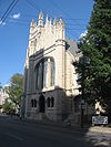
This is a list of properties and historic districts on the National Register of Historic Places in Old Louisville, Kentucky (roughly bounded by York St. and E. Jacob St. on the north; S. Floyd St. and I-65 on the east; E. Brandeis St. on the south; and S. 5th St., S. 7th St. and the CSX Railroad tracks on the west). Latitude and longitude coordinates of the 33 sites listed on this page may be displayed in a map or exported in several formats by clicking on one of the links in the adjacent box. [1]

Contents

National Register sites elsewhere in Jefferson County are listed separately.

This National Park Service list is complete through NPS recent listings posted July 30, 2021. [2]

Current listings

[3] Name on the RegisterImageDate listed [4] LocationDescription
1 Adath Israel Temple
Adath Israel Temple Adath Israel Temple in Louisville.jpg
Adath Israel Temple
December 31, 1974
(#74000882)
834 S. 3rd St.
38°14′35″N85°45′27″W / 38.2431°N 85.7575°W / 38.2431; -85.7575 (Adath Israel Temple)
2 Bayly-Schroering House
Bayly-Schroering House Bayly-Schroering House.jpg
Bayly-Schroering House
November 14, 1978
(#78001345)
1012 S. 4th St.
38°14′18″N85°45′37″W / 38.2384°N 85.7603°W / 38.2384; -85.7603 (Bayly-Schroering House)
3 Board of Extension of the Methodist Episcopal Church, South
Board of Extension of the Methodist Episcopal Church, South Board of Extension of the Methodist Episcopal Church, South.jpg
Board of Extension of the Methodist Episcopal Church, South
June 3, 1983
(#83002636)
1115 S. 4th St.
38°14′12″N85°45′33″W / 38.2368°N 85.7592°W / 38.2368; -85.7592 (Board of Extension of the Methodist Episcopal Church, South)
4 Calvary Episcopal Church
Calvary Episcopal Church Calvary Episcopal Church in Louisville from northwest.jpg
Calvary Episcopal Church
January 18, 1978
(#78001347)
821 S. 4th St.
38°14′36″N85°45′31″W / 38.2433°N 85.7586°W / 38.2433; -85.7586 (Calvary Episcopal Church)
5 Church of the Messiah
Church of the Messiah Church of the Messiah, First Unitarian-Universalist Church.jpg
Church of the Messiah
April 21, 1976
(#76000903)
805 S. 4th St.
38°14′38″N85°45′30″W / 38.2439°N 85.7583°W / 38.2439; -85.7583 (Church of the Messiah)
6 College Street Presbyterian Church
College Street Presbyterian Church College Street Presbyterian Church site.jpg
College Street Presbyterian Church
November 29, 1978
(#78001350)
113 W. College St.
38°14′36″N85°45′17″W / 38.2433°N 85.7547°W / 38.2433; -85.7547 (College Street Presbyterian Church)
7 Theophilus T. Conrad House-Rose Anna Hughes Presbyterian Widows Home
Theophilus T. Conrad House-Rose Anna Hughes Presbyterian Widows Home Conrad-Caldwell House Museum Louisville Kentucky.jpg
Theophilus T. Conrad House-Rose Anna Hughes Presbyterian Widows Home
June 9, 2021
(#100006661)
1402 St. James Ct.
38°13′45″N85°45′48″W / 38.2291°N 85.7633°W / 38.2291; -85.7633 (Theophilus T. Conrad House-Rose Anna Hughes Presbyterian Widows Home)
8 Cornwall and Brown Houses
Cornwall and Brown Houses Cornwall and Brown Houses site.jpg
Cornwall and Brown Houses
July 19, 1978
(#78001351)
957 S. 4th St.
38°14′23″N85°45′33″W / 38.2397°N 85.7592°W / 38.2397; -85.7592 (Cornwall and Brown Houses)
9 District #1
District #1 Italianate houses on East Breckinridge.jpg
District #1
June 3, 1983
(#83002655)
S. Brook and E. Breckinridge St.
38°14′29″N85°45′05″W / 38.2414°N 85.7514°W / 38.2414; -85.7514 (District #1)
10 District #2
District #2 Second north of Breckinridge in Louisville.jpg
District #2
June 3, 1983
(#83002656)
W. Breckinridge St. and S. 2nd St.
38°14′31″N85°45′22″W / 38.2419°N 85.7561°W / 38.2419; -85.7561 (District #2)
11 William J. Dodd Residence
William J. Dodd Residence William J. Dodd Residence.jpg
William J. Dodd Residence
August 5, 2010
(#10000530)
1448 St. James Court
38°13′39″N85°45′50″W / 38.2275°N 85.7639°W / 38.2275; -85.7639 (William J. Dodd Residence)
12 D.H. Ewing & Sons Creamery
D.H. Ewing & Sons Creamery D.H. Ewing and Sons Creamery.jpg
D.H. Ewing & Sons Creamery
June 3, 1983
(#83002662)
981 S. 3rd St.
38°14′20″N85°45′28″W / 38.238889°N 85.757778°W / 38.238889; -85.757778 (D.H. Ewing & Sons Creamery)
13 The Filson Club
The Filson Club Filson Club old building on Breckinridge.jpg
The Filson Club
June 20, 2013
(#13000476)
118 W. Breckinridge St.
38°14′28″N85°45′19″W / 38.241111°N 85.755139°W / 38.241111; -85.755139 (The Filson Club)
14 First Christian Church
First Christian Church Entrance to First Christian Church in Louisville.jpg
First Christian Church
July 16, 1979
(#79001005)
850 S. 4th St.
38°14′32″N85°45′34″W / 38.242222°N 85.759444°W / 38.242222; -85.759444 (First Christian Church)
15 First Street District
First Street District First Street District, Louisville.jpg
First Street District
July 14, 1984
(#84001555)
Roughly bounded by E. Breckinridge, E. Kentucky, and Interstate 65
38°14′26″N85°45′15″W / 38.240556°N 85.754167°W / 38.240556; -85.754167 (First Street District)
16 Fourth Avenue Methodist Episcopal Church
Fourth Avenue Methodist Episcopal Church Fourth Avenue Methodist Church in Old Louisville.jpg
Fourth Avenue Methodist Episcopal Church
July 16, 1979
(#79001006)
318 W. St. Catherine St.
38°14′14″N85°45′35″W / 38.237222°N 85.759722°W / 38.237222; -85.759722 (Fourth Avenue Methodist Episcopal Church)
17 Harig, Koop & Company-Columbia Mantel Company
Harig, Koop & Company-Columbia Mantel Company Harig, Koop & Company-Columbia Mantel Company.jpg
Harig, Koop & Company-Columbia Mantel Company
March 14, 1996
(#96000279)
845 S. 9th St.
38°14′36″N85°46′01″W / 38.243333°N 85.766944°W / 38.243333; -85.766944 (Harig, Koop & Company-Columbia Mantel Company)
18 Jewish Hospital Complex
Jewish Hospital Complex Jewish Hospital Complex in Louisville.jpg
Jewish Hospital Complex
July 22, 1994
(#94000732)
236 E. Kentucky St.
38°14′16″N85°45′05″W / 38.237778°N 85.751389°W / 38.237778; -85.751389 (Jewish Hospital Complex)
19 Kentucky Street School
Kentucky Street School Kentucky Street School.jpg
Kentucky Street School
June 3, 1983
(#83002691)
119 E. Kentucky St.
38°14′19″N85°45′13″W / 38.238611°N 85.753611°W / 38.238611; -85.753611 (Kentucky Street School)
20 Landward House
Landward House Landward House.jpg
Landward House
September 20, 1973
(#73000809)
1385-1387 S. 4th St.
38°13′46″N85°45′39″W / 38.229444°N 85.760833°W / 38.229444; -85.760833 (Landward House)
21 Louisville Gas and Electric Company Service Station Complex
Louisville Gas and Electric Company Service Station Complex Louisville Gas and Electric Company Service Station Complex.jpg
Louisville Gas and Electric Company Service Station Complex
March 17, 2015
(#15000082)
1228 S. 7th St.
38°14′03″N85°45′56″W / 38.2343°N 85.7655°W / 38.2343; -85.7655 (Louisville Gas and Electric Company Service Station Complex)
22 Louisville Male High School
Louisville Male High School Louisville Male High School, old building.jpg
Louisville Male High School
April 18, 1979
(#79001011)
911 S. Brook St.
38°14′26″N85°45′08″W / 38.240556°N 85.752222°W / 38.240556; -85.752222 (Louisville Male High School)
23 Louisville War Memorial Auditorium
Louisville War Memorial Auditorium Louisville War Memorial Auditorium.jpg
Louisville War Memorial Auditorium
December 27, 1977
(#77000625)
970 S. 4th St.
38°14′22″N85°45′36″W / 38.239444°N 85.76°W / 38.239444; -85.76 (Louisville War Memorial Auditorium)
24 Dr. J.B. Marvin House
Dr. J.B. Marvin House Dr. J.B. Marvin House.jpg
Dr. J.B. Marvin House
June 3, 1983
(#83002700)
809 S. 4th St.
38°14′38″N85°45′31″W / 38.243889°N 85.758611°W / 38.243889; -85.758611 (Dr. J.B. Marvin House)
25 Nugent House July 1, 2020
(#100005342)
845 South 6th St.
38°14′35″N85°45′44″W / 38.2430°N 85.7623°W / 38.2430; -85.7623 (Nugent House)
26 Old Louisville Residential District
Old Louisville Residential District Werne's Row 4th and Hill, Old Louisville.jpg
Old Louisville Residential District
February 7, 1975
(#75000772)
Irregular pattern roughly bounded by S. 7th St. on the west, North-South Expressway (Interstate 65) on the east, Kentucky St. on the north, and Avery St. on the south; also roughly bounded by Interstate 65 and 7th, Kentucky, and Avery Sts.
38°13′46″N85°45′33″W / 38.2294°N 85.7592°W / 38.2294; -85.7592 (Old Louisville Residential District)
Second set of boundaries represents a boundary increase of July 12, 1984
27 The Olympic
The Olympic The Olympic in Louisville.jpg
The Olympic
July 9, 2007
(#07000677)
223 W. Breckinridge St.
38°14′31″N85°45′26″W / 38.2419°N 85.7572°W / 38.2419; -85.7572 (The Olympic)
28 Porter-Todd House
Porter-Todd House Porter-Todd House site.jpg
Porter-Todd House
April 30, 1979
(#79001013)
929 S. 4th St.
38°14′24″N85°45′33″W / 38.2400°N 85.7592°W / 38.2400; -85.7592 (Porter-Todd House)
29 Presentation Academy
Presentation Academy Presentation Academy from the southwest.jpg
Presentation Academy
December 22, 1978
(#78001364)
861 S. 4th St.
38°14′32″N85°45′32″W / 38.2422°N 85.7589°W / 38.2422; -85.7589 (Presentation Academy)
30 Puritan Apartment Hotel
Puritan Apartment Hotel Puritan Post Card.jpg
Puritan Apartment Hotel
February 28, 2019
(#100003475)
1244 S. Fourth St.
38°14′02″N85°45′38″W / 38.2339°N 85.7605°W / 38.2339; -85.7605 (Puritan Apartment Hotel)
31 Rauchfuss Houses
Rauchfuss Houses Rauchfuss Houses site.jpg
Rauchfuss Houses
August 12, 1982
(#82002716)
837-847 S. Brook St.
38°14′29″N85°45′08″W / 38.2414°N 85.7522°W / 38.2414; -85.7522 (Rauchfuss Houses)
32 St. James-Belgravia Historic District
St. James-Belgravia Historic District Conrad Historic Home, Old Louisville KY.jpg
St. James-Belgravia Historic District
December 5, 1972
(#72000538)
Roughly bounded by Central Park, S. 4th, S. 6th, and Hill Sts.
38°13′40″N85°45′48″W / 38.2278°N 85.7633°W / 38.2278; -85.7633 (St. James-Belgravia Historic District)
33 Steam Engine Company No. 7
Steam Engine Company No. 7 Steam Engine Company No. 7.jpg
Steam Engine Company No. 7
November 7, 1980
(#80001631)
821 S. 6th St.
38°14′38″N85°45′43″W / 38.2438°N 85.7619°W / 38.2438; -85.7619 (Steam Engine Company No. 7)
34 Thierman Apartments
Thierman Apartments Thierman Apartments.jpg
Thierman Apartments
June 3, 1983
(#83002740)
416-420 W. Breckinridge St.
38°14′30″N85°45′36″W / 38.2417°N 85.7600°W / 38.2417; -85.7600 (Thierman Apartments)
35 Tompkins-Buchanan House
Tompkins-Buchanan House Spalding University administration building.jpg
Tompkins-Buchanan House
April 27, 1977
(#77000628)
851 S. 4th St.
38°14′33″N85°45′32″W / 38.2425°N 85.7589°W / 38.2425; -85.7589 (Tompkins-Buchanan House)

See also

Related Research Articles

National Register of Historic Places listings in Jefferson County, Kentucky

The table below includes sites listed on the National Register of Historic Places (NRHP) in Jefferson County, Kentucky except those in the following neighborhoods/districts of Louisville: Anchorage, Downtown, The Highlands, Old Louisville, Portland and the West End. Links to tables of listings in these other areas are provided below.

National Register of Historic Places listings in Jefferson County, Florida

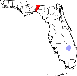
This is a list of the National Register of Historic Places listings in Jefferson County, Florida.

This is a list of properties and historic districts on the National Register of Historic Places in downtown Louisville, Kentucky. Latitude and longitude coordinates of the 85 sites listed on this page may be displayed in a map or exported in several formats by clicking on one of the links in the adjacent box.

National Register of Historic Places listings in Jefferson County, Pennsylvania

This is a list of the National Register of Historic Places listings in Jefferson County, Pennsylvania.

National Register of Historic Places listings in Jefferson County, West Virginia

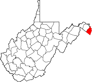
This is a list of the National Register of Historic Places listings in Jefferson County, West Virginia.

This is a list of properties and historic districts on the National Register of Historic Places in Anchorage, Kentucky. Latitude and longitude coordinates of the 35 sites listed on this page may be displayed in a map or exported in several formats by clicking on one of the links in the adjacent box.

This is a list of properties and historic districts on the National Register of Historic Places in the Portland neighborhood of Louisville, Kentucky (roughly bounded by the Ohio River on the north; N. 10th St. to the east; W. Market St. to the south; and I-264 and the Shawnee Golf Course to the west. Latitude and longitude coordinates of the 35 sites listed on this page may be displayed in a map or exported in several formats by clicking on one of the links in the adjacent box.

This is a list of properties and historic districts on the National Register of Historic Places in the West End of Louisville, Kentucky. The table below includes 49 listings in the following neighborhoods:

National Register of Historic Places listings in Shelby County, Kentucky

This is a list of the National Register of Historic Places listings in Shelby County, Kentucky.

National Register of Historic Places listings in Trimble County, Kentucky Wikipedia list article

This is a list of the National Register of Historic Places listings in Trimble County, Kentucky.

National Register of Historic Places listings in Spencer County, Kentucky

This is a list of the National Register of Historic Places listings in Spencer County, Kentucky.

National Register of Historic Places listings in Meade County, Kentucky

This is a list of the National Register of Historic Places listings in Meade County, Kentucky.

National Register of Historic Places listings in Nelson County, Kentucky

This is a list of the National Register of Historic Places listings in Nelson County, Kentucky.

National Register of Historic Places listings in Oldham County, Kentucky

This is a list of the National Register of Historic Places listings in Oldham County, Kentucky.

National Register of Historic Places listings in Henry County, Kentucky

This is a list of the National Register of Historic Places listings in Henry County, Kentucky.

National Register of Historic Places listings in Clark County, Indiana

This is a list of the National Register of Historic Places listings in Clark County, Indiana.

National Register of Historic Places listings in Floyd County, Indiana

This is a list of the National Register of Historic Places listings in Floyd County, Indiana.

National Register of Historic Places listings in Harrison County, Indiana

This is a list of the National Register of Historic Places listings in Harrison County, Indiana.

National Register of Historic Places listings in Bullitt County, Kentucky

This is a list of the National Register of Historic Places listings in Bullitt County, Kentucky.

This is a list of properties and historic districts on the National Register of Historic Places in The Highlands, Louisville, Kentucky. The table below includes 30 listings in the following neighborhoods:

References

  1. The latitude and longitude information provided in this table was derived originally from the National Register Information System, which has been found to be fairly accurate for about 99% of listings. Some locations in this table may have been corrected to current GPS standards.
  2. National Park Service, United States Department of the Interior, "National Register of Historic Places: Weekly List Actions", retrieved July 30, 2021.
  3. Numbers represent an alphabetical ordering by significant words. Various colorings, defined here, differentiate National Historic Landmarks and historic districts from other NRHP buildings, structures, sites or objects.
  4. The eight-digit number below each date is the number assigned to each location in the National Register Information System database, which can be viewed by clicking the number.