National Register of Historic Places listings in Quay County, New Mexico

Last updated
Location of Quay County in New Mexico Map of New Mexico highlighting Quay County.svg
Location of Quay County in New Mexico

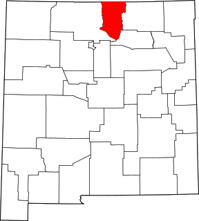
This is a list of the National Register of Historic Places listings in Quay County, New Mexico.

Contents

This is intended to be a complete list of the properties and districts on the National Register of Historic Places in Quay County, New Mexico, United States. Latitude and longitude coordinates are provided for many National Register properties and districts; these locations may be seen together in a map. [1]

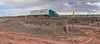
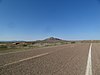
There are 12 properties and districts listed on the National Register in the county. Another property was once listed but has been removed. All of the places within the county on the National Register are also listed on the State Register of Cultural Properties with the single exception of the Arch Hurley Conservancy District Office Building.

This National Park Service list is complete through NPS recent listings posted September 4, 2020. [2]
Map all coordinates using: OpenStreetMap  
Download coordinates as: KML  ·  GPX
Contents: NRHP in New Mexico by county
Bernalillo  Catron  Chaves  Cibola  Colfax  Curry  De Baca  Doña Ana  Eddy  Grant  Guadalupe  Harding  Hidalgo  Lea  Lincoln  Los Alamos  Luna  McKinley  Mora  Otero  Quay  Rio Arriba  Roosevelt  San Juan  San Miguel  Sandoval  Santa Fe  Sierra  Socorro  Taos  Torrance  Union  Valencia

Current listings

[3] Name on the Register [4] ImageDate listed [5] Location City or townDescription
1 Blue Swallow Motel
Blue Swallow Motel Blue Swallow Motel sign from W 1.JPG
Blue Swallow Motel
November 22, 1993
(#93001210)
815 E. Tucumcari Boulevard
35°10′19″N103°42′58″W / 35.17206°N 103.71622°W / 35.17206; -103.71622 (Blue Swallow Motel)
Tucumcari
2 Cactus Motor Lodge
Cactus Motor Lodge Cactus RV Park (Tucumcari, NM) sign from W.JPG
Cactus Motor Lodge
March 21, 2006
(#06000154)
1316 E. Tucumcari Boulevard
35°10′16″N103°42′38″W / 35.17111°N 103.71056°W / 35.17111; -103.71056 (Cactus Motor Lodge)
Tucumcari Now Cactus RV Park. [6]
3 Glenrio Historic District
Glenrio Historic District Glenrio NM Tex Cafe.jpg
Glenrio Historic District
January 17, 2007
(#06001258)
State Road 1578
35°10′43″N103°02′33″W / 35.178611°N 103.0425°W / 35.178611; -103.0425 (Glenrio Historic District)
Glenrio Extends into Deaf Smith County, Texas
4 Arch Hurley Conservancy District Office Building
Arch Hurley Conservancy District Office Building Arch Hurley Conservancy Bldg from SE 1.JPG
Arch Hurley Conservancy District Office Building
December 16, 1994
(#94001403)
101 E. High St.
35°10′34″N103°43′32″W / 35.176111°N 103.725556°W / 35.176111; -103.725556 (Arch Hurley Conservancy District Office Building)
Tucumcari
5 Metropolitan Park Bathhouse and Pool Historic District
Metropolitan Park Bathhouse and Pool Historic District Metropolitan Park Bathhouse and Pool Historic District 2013-09-19 09-25-13.jpg
Metropolitan Park Bathhouse and Pool Historic District
March 15, 1996
(#96000268)
South frontage road of Interstate 40, 1.5 miles west of the western exit for Tucumcari
35°08′43″N103°48′01″W / 35.145278°N 103.800278°W / 35.145278; -103.800278 (Metropolitan Park Bathhouse and Pool Historic District)
Tucumcari
6 Nara Visa School
Nara Visa School School 1 Nara Visa New Mexico.jpg
Nara Visa School
October 31, 1983
(#83004151)
U.S. Route 54
35°36′51″N103°05′53″W / 35.614167°N 103.098056°W / 35.614167; -103.098056 (Nara Visa School)
Nara Visa
7 Odeon Theater
Odeon Theater Tucumcari Odeon Theater from SE 2.JPG
Odeon Theater
January 17, 2007
(#06001254)
123 S. 2nd St.
35°10′48″N103°43′37″W / 35.18°N 103.726944°W / 35.18; -103.726944 (Odeon Theater)
Tucumcari
8 Richardson Store
Richardson Store Richardson store (Montoya NM) from SW 1.JPG
Richardson Store
November 16, 1978
(#78001819)
Off Interstate 40
35°05′43″N104°03′55″W / 35.095377°N 104.065319°W / 35.095377; -104.065319 (Richardson Store)
Montoya
9 Route 66, Locally Maintained from Glenrio to San Jon
Route 66, Locally Maintained from Glenrio to San Jon Glen Rio to San Jon.jpg
Route 66, Locally Maintained from Glenrio to San Jon
March 24, 1994
(#93001207)
Texas border west to San Jon
35°08′12″N103°09′37″W / 35.136667°N 103.160278°W / 35.136667; -103.160278 (Route 66, Locally Maintained from Glenrio to San Jon)
San Jon
10 Route 66, State maintained from Montoya to Cuervo
Route 66, State maintained from Montoya to Cuervo Route 66 culvert 16.1 mi E of Cuervo NM.JPG
Route 66, State maintained from Montoya to Cuervo
November 19, 1997
(#97001395)
Along former U.S. Route 66 from west of Montoya to Cuervo
35°03′41″N104°16′01″W / 35.061389°N 104.266944°W / 35.061389; -104.266944 (Route 66, State maintained from Montoya to Cuervo)
Cuervo
11 Route 66, State maintained from Palomas to Montoya
Route 66, State maintained from Palomas to Montoya Route 66 bridge 2.5 miles east of Montoya NM from NW 1.JPG
Route 66, State maintained from Palomas to Montoya
March 24, 1994
(#93001208)
State frontage road from southeast of Palomas west to Montoya
35°06′43″N103°58′05″W / 35.111944°N 103.968056°W / 35.111944; -103.968056 (Route 66, State maintained from Palomas to Montoya)
Montoya
12 Route 66, State maintained from San Jon to Tucumcari
Route 66, State maintained from San Jon to Tucumcari Tucumcari to San Jon.jpg
Route 66, State maintained from San Jon to Tucumcari
November 19, 1997
(#97001399)
Former U.S. Route 66 from east of San Jon to east of the Interstate 40 exit at Tucumcari
35°08′46″N103°27′09″W / 35.146111°N 103.4525°W / 35.146111; -103.4525 (Route 66, State maintained from San Jon to Tucumcari)
San Jon

Former listing

[3] Name on the RegisterImageDate listed/removedLocationCity or townSummary
1 Baca-Goodman House
Baca-Goodman House Baca-Goodman.jpg
Baca-Goodman House
Listed 1973, delisted January 1, 1977
(#73002246)
Aber and 3rd Sts.
35°10′38″N103°43′40″W / 35.177222°N 103.727778°W / 35.177222; -103.727778 (Baca-Goodman House)
Tucumcari Destroyed.

See also

Related Research Articles

National Register of Historic Places listings in New Mexico Wikimedia list article

This is a list of properties and districts in New Mexico that are on the National Register of Historic Places. There are more than 1,100 listings. Of these, 46 are National Historic Landmarks. There are listings in each of the state's 33 counties.

National Register of Historic Places listings in Valencia County, New Mexico Wikimedia list article

This is a list of the National Register of Historic Places listings in Valencia County, New Mexico.

National Register of Historic Places listings in Taos County, New Mexico Wikimedia list article

This is a list of the National Register of Historic Places listings in Taos County, New Mexico.

National Register of Historic Places listings in Bernalillo County, New Mexico Wikimedia list article

This is a list of the National Register of Historic Places listings in Bernalillo County, New Mexico.

National Register of Historic Places listings in San Miguel County, New Mexico Wikimedia list article

This is a list of the National Register of Historic Places listings in San Miguel County, New Mexico.

National Register of Historic Places listings in Rio Arriba County, New Mexico Wikimedia list article

This is a list of the National Register of Historic Places listings in Rio Arriba County, New Mexico.

National Register of Historic Places listings in McKinley County, New Mexico Wikimedia list article

This is a list of the National Register of Historic Places listings in McKinley County, New Mexico.

National Register of Historic Places listings in Grant County, New Mexico Wikimedia list article

This is a list of the National Register of Historic Places listings in Grant County, New Mexico.

National Register of Historic Places listings in Colfax County, New Mexico Wikimedia list article

This is a list of the National Register of Historic Places listings in Colfax County, New Mexico.

National Register of Historic Places listings in Hidalgo County, New Mexico Wikimedia list article

This is a list of the National Register of Historic Places listings in Hidalgo County, New Mexico.

National Register of Historic Places listings in Eddy County, New Mexico Wikimedia list article

This is a list of the National Register of Historic Places listings in Eddy County, New Mexico.

National Register of Historic Places listings in Doña Ana County, New Mexico Wikimedia list article

This is a list of the National Register of Historic Places listings in Doña Ana County, New Mexico.

National Register of Historic Places listings in Lincoln County, New Mexico Wikimedia list article

This is a list of the National Register of Historic Places listings in Lincoln County, New Mexico.

National Register of Historic Places listings in Mora County, New Mexico Wikimedia list article

This is a list of the National Register of Historic Places listings in Mora County, New Mexico.

National Register of Historic Places listings in Chaves County, New Mexico Wikimedia list article

This is a list of the National Register of Historic Places listings in Chaves County, New Mexico.

National Register of Historic Places listings in Catron County, New Mexico

This is a list of the National Register of Historic Places listings in Catron County, New Mexico.

National Register of Historic Places listings in De Baca County, New Mexico

This is a list of the National Register of Historic Places listings in De Baca County, New Mexico.

National Register of Historic Places listings in Harding County, New Mexico

This is a list of the National Register of Historic Places listings in Harding County, New Mexico.

National Register of Historic Places listings in Torrance County, New Mexico

This is a list of the National Register of Historic Places listings in Torrance County, New Mexico.

National Register of Historic Places listings in Union County, New Mexico

This is a list of the National Register of Historic Places listings in Union County, New Mexico.

References

  1. The latitude and longitude information provided in this table was derived originally from the National Register Information System, which has been found to be fairly accurate for about 99% of listings. Some locations in this table may have been corrected to current GPS standards.
  2. "National Register of Historic Places: Weekly List Actions". National Park Service, United States Department of the Interior. Retrieved on September 4, 2020.
  3. 1 2 Numbers represent an ordering by significant words. Various colorings, defined here, differentiate National Historic Landmarks and historic districts from other NRHP buildings, structures, sites or objects.
  4. "National Register Information System". National Register of Historic Places . National Park Service. July 9, 2010.
  5. The eight-digit number below each date is the number assigned to each location in the National Register Information System database, which can be viewed by clicking the number.
  6. Cactus RV Park website. Retrieved 2012-02-11.