This is a list of properties and historic districts on the National Register of Historic Places in The Highlands, Louisville, Kentucky. The table below includes 32 listings in the following neighborhoods:
Latitude and longitude coordinates of the sites listed on this page may be displayed in a map or exported in several formats by clicking on one of the links in the box below the map to the right. [1]
National Register sites elsewhere in Jefferson County are listed separately.
This National Park Service list is complete through NPS recent listings posted April 26, 2024. [2]
| [3] | Name on the Register | Image | Date listed | Date removed | Location | Neighborhood | Description |
|---|---|---|---|---|---|---|---|
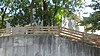
| 1 | August Bloedner Monument |  | July 17, 1997 (#97000688) | November 19, 2010 | 701 Baxter Ave. 38°14′54″N85°43′19″W / 38.248333°N 85.721944°W | Cherokee Triangle | Formerly in the Cave Hill Cemetery, junction of Payne St. and Lexington Rd. Now located at the Frazier History Museum. Delisted due to relocation of the monument. |

List of the National Register of Historic Places listings in Jefferson County, New York

The table below includes sites listed on the National Register of Historic Places (NRHP) in Jefferson County, Kentucky except those in the following neighborhoods/districts of Louisville: Anchorage, Downtown, The Highlands, Old Louisville, Portland and the West End. Links to tables of listings in these other areas are provided below.
This is a list of properties and historic districts on the National Register of Historic Places in downtown Louisville, Kentucky. Latitude and longitude coordinates of the 86 sites listed on this page may be displayed in a map or exported in several formats by clicking on one of the links in the adjacent box.

This is a list of the National Register of Historic Places listings in Jefferson County, Pennsylvania.

This is a list of the National Register of Historic Places listings in Highlands County, Florida.
This is a list of properties and historic districts on the National Register of Historic Places in Anchorage, Kentucky. Latitude and longitude coordinates of the 35 sites listed on this page may be displayed in a map or exported in several formats by clicking on one of the links in the adjacent box.
This is a list of properties and historic districts on the National Register of Historic Places in the Portland neighborhood of Louisville, Kentucky (roughly bounded by the Ohio River on the north; N. 10th St. to the east; W. Market St. to the south; and I-264 and the Shawnee Golf Course to the west. Latitude and longitude coordinates of the 35 sites listed on this page may be displayed in a map or exported in several formats by clicking on one of the links in the adjacent box.
This is a list of properties and historic districts on the National Register of Historic Places in the West End of Louisville, Kentucky. The table below includes 51 listings in the following neighborhoods:

This is a list of the National Register of Historic Places listings in Shelby County, Kentucky.

This is a list of the National Register of Historic Places listings in Whitley County, Kentucky.

This is a list of the National Register of Historic Places listings in Trimble County, Kentucky.

This is a list of the National Register of Historic Places listings in Spencer County, Kentucky.

This is a list of the National Register of Historic Places listings in Meade County, Kentucky.

This is a list of the National Register of Historic Places listings in Nelson County, Kentucky.

This is a list of the National Register of Historic Places listings in Oldham County, Kentucky.

This is a list of the National Register of Historic Places listings in Henry County, Kentucky.

This is a list of the National Register of Historic Places listings in Clark County, Indiana.
This is a list of the National Register of Historic Places listings in Floyd County, Indiana.

This is a list of the National Register of Historic Places listings in Bullitt County, Kentucky.
This is a list of properties and historic districts on the National Register of Historic Places in Old Louisville, Kentucky. Latitude and longitude coordinates of the 33 sites listed on this page may be displayed in a map or exported in several formats by clicking on one of the links in the adjacent box.
| Topics | |
|---|---|
| Lists by state |
|
| Lists by insular areas | |
| Lists by associated state | |
| Other areas | |
| Related | |